 Close
Close

Departmental Newsletter Spring 2020
Student Experience: Central America Volcanic Arc.

The moment of my dreams a night up a volcano to watch continuous strombolian flares shoot into the night sky from Fuego’s crater.
Meet the Staff: Dr Peter Irvine

I am interested how human actions transform the Earth and how humanity can learn to manage this transformation.
Press Release: Reducing climate change risks.

Injecting the right dose of sulphur dioxide into Earth’s upper atmosphere could reduce the effects of climate change overall.
Hazard Centre: When volcanoes collapse.
![Discovering tsunami deposits on Sebesi Island [Photo: D.R. Tappin].](https://www.ucl.ac.uk/earth-sciences/sites/earth_sciences/files/styles/medium_image/public/hazards-news2020-2.jpg?itok=XyjO4NNR "Discovering tsunami deposits on Sebesi Island [Photo: D.R. Tappin].")
Single, large-volume collapses trigger tsunamis that can travel greater distances and can flood further inland along exposed coasts..
Research: Five hundred miles from civilisation.

It’s a strange feeling to realise that your closest human neighbours are on the international space station…!
Outreach: GeoBus is off the road.

The global COVID-19 pandemic has changed the team’s trajectory, enforcing a pause from normal activities and a switch to creating online content.
Events: Women in Earth Sciences Conference

WiES 2020: Celebrating Women in Earth Science due to take place in June was now cancelled due to COVID-19 pandemic.
PhD News: Snow Science Winter School.

The week long school brings twenty-four grad students into the mountains for a crash course on measurement, modeling and remote sensing of snow.
Alumni News: The best MSc dissertation award.

The Curry prize is awarded by the Geologists’ Association in a subject relevant to earth sciences for a dissertation of outstanding quality.
Update from Prof Paul Upchurch, Head of Department.
I hope everyone reading this is safe and well. This will probably be the most unusual newsletter contribution I ever write. Our Department building has been dealing with the national shutdown for around a month now. Nevertheless, the Department continues to function temporarily as a virtual online entity. First, I must acknowledge the incredible efforts of staff and PhD students to transform our normal face-to-face teaching. This is particularly tricky in a subject area that depends so heavily on lab work and field trips. Yet for this term, we have put together virtual field trips which include videos of staff talking in front of key locations, 3D images of rocks and outcrops that can be examined from different angles and at different magnifications, and even offer opportunities to practice logging sections and other mapping skills. While we are doing this now because of the impact of Covid19, we also appreciate that creating these virtual field trips has other benefits, and will provide a tremendous resource for the future alongside our existing high quality teaching. In particular, students who are unable to attend field courses because they are ill, or have a disability, will be able to use these and other resources to gain the knowledge they need in order to become well-rounded Earth Scientists. Such resources can also be used in outreach and to give prospective students a clear and exciting feel for what we offer.
Research also continues, of course. In particular, I am aware that we all have an opportunity to focus on writing papers and grants, which should bear fruit in the short and medium term. Many staff have existing data sets that can be exploited in order to keep research going over the next few months. And, such is the frenetic nature of academic life, it can be hard to keep up with the burgeoning scientific literature: now we have an opportunity to read around for interest and perhaps spark some ideas for future research directions and collaborations.
Finally, it is exciting to see how the use of social media and other online platforms is allowing us to continue to interact. Aside from holding virtual meetings to discuss research and teaching, online versions of seminar series are starting to reappear, and a variety of coffee mornings have been set up to enhance social interactions. Thus, while the impact of Covid19 is clearly profound, I think it is very likely that in future we will employ a more diverse and stronger approach to how we organise Departmental activities. We should then be able to combine the best aspects of face-to-face and virtual interactions to improve efficiency and productivity, increase accessibility and diversity, and engage with a wider audience.
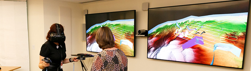
Earth Sciences enters the world of online fieldtrips and virtual reality.
by Paul Bown, David Dobson, Danuta Kaminski, Emma Liu and Tom Mitchell
As during the lockdown remote teaching and learning become the new norm and virtual activities temporarily replace face-to-face interactions, there are huge implications for Earth Science teaching, perhaps most obviously for field work related activities. The department has had to cancel all four of its major 2019/20 Easter field courses (Cornwall, Dorset, Pyrenees and Betics) but we are using the current lockdown as an opportunity to revolutionise the way our teaching engages with virtual materials. The new resources include online virtual field trips and, when students return to UCL, the applications of virtual reality. These resources will continue to enhance our teaching long after the current situation has ended by, among other things, transforming accessibility to field teaching. However, we are not replacing the real field experience but only enhancing and enriching the field programme. We aim to restart our fieldwork schedule next academic year.
The concept of Virtual Reality, or VR, is not new, having emerged on to the global scene in the 1960s, albeit not in the form we now know it. As the technology developed, forms of VR were introduced into pilot flight simulators and into NASA training exercises. In the past few years, however, an explosion of new applications have adopted VR, including a wide range of scientific research. In the Earth Sciences, VR is contributing to our understanding of mineral networks, of quantifying landslide displacements, and of analysing the internal structure of volcanic plumes, among many more. Importantly, we are now recognising the power of VR as an integral component of the educational experience. VR is immersive; it allows the user to fully interact with their surroundings. Some open-source software packages now enable you to take measurements ‘by hand’ within the virtual space. The foundation of many VR experiences is a digital elevation model, or DEM, such as those that can be generated from structure-from-motion photogrammetry. Importing this DEM into the virtual space takes it from a 2D projection of a 3D feature, to a fully interactive 3D landscape.
Caption: Overview of the virtual fieldwork project by Dr Tom Mitchell (left); Caption: Year 1 Fieldtrip to Cornwall: Cornwall Porth Ledden - Mylor Slate - Granite Contact. (right)
With MAPS Faculty support, UCL Earth Sciences have invested in the technology needed to bring VR into our teaching. We now have the equipment as well as the expertise to start to take real field outcrops and explore them in virtual space. Fieldwork is a fundamental activity in our teaching curriculum and we cannot stress enough the importance of using this natural laboratory so students can learn geological skills from rock identification to solving complex 3D structures in situ. Utilizing techniques learned in lectures and laboratory-based coursework, students are expected to investigate and identify geological features and phenomena through direct observation. This year the COVID-19 pandemic is depriving our students of this direct field experience and we took the decision to provide an alternative learning experience rather than abandon field work entirely. We are creating a virtual-fieldwork web site with interactive content that will require active participation from our students. We will integrate traditional field guides, figures and text with innovative 3D model exercises, annotated zoomable high-resolution images, infographics and quizzes. This will include parts of our earlier “Lecturecast in the Field” project which included video footage that captured real time teaching in the field.
Looking ahead, through these resources we are committing to improving field work accessibility, by opening up field and practical activities to those students who would otherwise be unable to participate. Virtual versions of our Cornwall, Dorset, Pyrenees and Betics field trips will also provide valuable complementary resources for students who are able to experience the real thing. The virtual fieldtrip team are working hard to pull together digital materials that will allow students to engage with the natural examples that are so important to solidify taught concepts. VR will then bring these digital resources to life.
Eillish Brennan, MSci Earth Sciences International Programme Student
Masters project fieldwork in Central America Volcanic Arc.
Despite living in the mountains as a child England is unfortunately limited to its ancient volcanic remanence. I was still desperate to see some active volcanoes in person. So it became my goal last summer to try and tick off as many volcanoes as possible. Luckily being in California for the year, on my international programme, the Central American Arc was on my doorstep. Deciding that I was not going to finish my degree without at least one field-trip to observe some volcanic activity, I decided to document this trip and make it into a personal project.
I began looking for a way to help fund my trip: the guides, the remote locations, and the national parks which lead me to the UCL Global Experience Bursary. I secured support for my project from a member of staff from Earth Sciences and secured funding for my research projects. As I planned my trip, I realised this would be a unique opportunity to collect my own samples with the potential to conduct a masters project when I returned home. I've always wanted the opportunity to study an active volcano myself, so I set off with my hand lens and yellow notebook in the hope of becoming a volcanologist. However the hastiness of the trip and distance from home meant that I was doing fieldwork based on a few papers I could find about the various locations we were visiting, along with lava flow fields maps I'd printed. Whilst I thought the lavas would be best to collect, in hindsight for my current project tephra (airborne rock fragments and particles from an eruption) would have been more suitable.


On return it wasn't long before Prof. Adrian Jones and I came up with a project after noticing that Cerro Negro samples had a large quantity of pristine and interesting olivine with the other volcanoes known to mineralogically contain olivine too. Then the work started: “A search for Olivine-hosted melt inclusions in the active Central CAVAs (Central American Volcanic Arc) Volcanoes Arenal, Concepción, Masaya and Cerro Negro to explore the degassing of basaltic systems”. It was time to learn everything, starting with what a melt inclusion was and what they can say about a volcanoes life cycle..
Meet Dr Peter Irvine, Lecturer in Climate Change
I studied Physics for my undergraduate as I was drawn to the idea that understanding the fundamentals of systems could reveal radical possibilities. As I reached the end of my course, my interests broadened and I became more interested in philosophy, history, and messy political problems. I knew I wanted to get into research, but I felt that most physics research was too esoteric and remote from every-day concerns. I also wanted to work on something that could have a positive impact on the environmental problems we face now.
While struggling to choose a direction to take after my undergraduate, I stumbled across an advert for a PhD modeling the climate effects of solar geoengineering. It ticked all the boxes of what I was looking for: a potentially transformative application of science that might help address climate change, and which clearly posed some thorny ethical and political issues. Since completing my PhD at Bristol in 2012, I’ve worked on this topic ever since; first, at the Institute for Advanced Sustainability Studies in Potsdam, then at Harvard.
My research has 3 broad strands: First, I work with climate and Earth system models to understand the potential impacts of climate change and solar geoengineering, e.g. on the terrestrial hydrological cycle and on sea-level rise. Second, I work to synthesize and interpret these findings; developing analysis approaches for evaluating the overall balance of risks and benefits from solar geoengineering and working to improve representations of solar geoengineering in economic and other models. Thirdly, I collaborate with researchers from a range of disciplines to explore the implications of solar geoengineering in their fields, e.g. I have collaborated with others to explore the ethical and legal challenges of compensation for solar geoengineering and to understand its governance implications.

While my research has focused on solar geoengineering to date, I’m looking to work on some of the nearer-term challenges posed by humanity’s interactions with the natural world. For example, I’m interested in how terrestrial hydrology will be altered by climate change, and how humanity and the biosphere will shape this change and be shaped by it.
If you’re interested in research on how human actions are changing the climate and broader Earth system, or in the possibility of solar geoengineering, get in contact!
Follow me on Twitter: @peteirvine or email me at: p.irvine@ucl.ac.uk
Links:
- Dr Peter Irvine's academic profile
- The right dose of geoengineering could reduce climate change risks. March 2020
- Research paper in Environmental Research Letters
- Research paper in Nature Climate Change
News from the UCL Hazard Centre: When volcanoes collapse.
Dave Tappin (UCL Hazard Centre Affiliate and British Geological Survey) investigates the threat from tsunamis when volcanoes collapse into the sea.
Lethal tsunamis are normally linked with undersea earthquakes. Over the past 20 years, however, it has become clear that coastal and submarine landslides pose a similar threat. The danger from collapsing volcanoes is expecially acute. When their flanks fail, they can deliver landslides with volumes of 0.1-1 km3 - and, occasionally, of ~10-100 km3 - across the sea floor. A remaining controversy is whether collapses can occur in a single go instead of a succession of smaller events. The difference is important, because, compared with the piecemeal process, single, large-volume collapses trigger tsunamis that can travel greater distances and can flood further inland along exposed coasts.
![The 2018 collapse of Anak Krakatau (grey island with crater in white) deposited numerous blocks hundreds of metres across on the sea floor to the southwest (pale blue-grey) [Image: D.R. Tappin].](https://www.ucl.ac.uk/earth-sciences/sites/earth_sciences/files/styles/xl_image/public/hazards-news2020.jpg?itok=_xzO7UrR "The 2018 collapse of Anak Krakatau (grey island with crater in white) deposited numerous blocks hundreds of metres across on the sea floor to the southwest (pale blue-grey) [Image: D.R. Tappin].")
Our latest studies have taken us to the volcanic island Anak Krakatau, in the Sunda Straits between Java and Sumatra in Indonesia. Three days before Christmas 2018, a catastrophic collapse of the volcano's southwest flank triggered a tsunami that needed just 30 minutes to injure 13,000 people along neighbouring coastlines [1]. Surveying the sea floor to depths of 200 m, we found that the landslide had run out to distances of 2 km as a small number of large blocks within a field of smaller debris. The large blocks suggest that the landslide was produced by a single collapse of about 0.2 km3, rather than by a sequence of smaller, piecemeal collapses [1, 2]. Single-collapse scenarios are thus essential for modelling future hazards.
We have followed up the surveys with field measurements of the tsunami deposits in Java and Sumatra. Many of the remote locations could only be reached from the sea and had rarely been visited by non-Indonesians. We were thus extremely excited when we discovered, beneath the 2018 sediments, deposits from tsunamis that had not previously been recorded. We are now compiling these for a comprehensive analysis of how frequently tsunamis have occurred in the region.
Tsunamis, though, are not the only natural hazards. One local inhabitant in southwestern Sumatra recalled the time in 1973 when tigers came out of the forest to the coast. One of his friends was killed and eaten. When asked his reaction, he replied – “I got married quick!".
References:
[1] Grilli, S.T., Tappin, D.R. et al. 2019. Modelling of the tsunami from the December 22, 2018 lateral collapse of Anak Krakatau volcano in the Sunda Straits, Indonesia. Scientific Reports 9, 11946; https://www.nature.com/articles/s41598-019-48327-6
[2] Amos, J. 2019. Anak Krakatau: Giant blocks of rock litter ocean floor. BBC News. https://www.bbc.co.uk/news/science-environment-50798253
Five hundred miles from civilisation.
Exploring active volcanism in the South Sandwich Islands. By Emma Liu - Lecturer & Leverhulme Early Career Research Fellow in Volcanology.
“This expedition challenged me in every way. It was an intense five weeks aboard the Pelagic Australis and a truly once-in-a-lifetime experience. The South Sandwich Islands are harsh, inhospitable environments and the oceans around them are exposed and unforgiving. Every minute that we were able to be ashore was a privilege, and every observation and measurement was hard won. Few volcanologists have ever visited these Islands, and fewer still have landed ashore. We have joined a small handful of people who have had the opportunity to study these remote and enigmatic volcanoes up close, and I’ve come away with a renewed appreciation of why that is.”
In January 2020, I visited the South Sandwich Islands as part of a multi-disciplinary scientific expedition to explore the unique ecology, volcanology, and glaciology of these remote island environments. The South Sandwich Islands are a chain of active volcanoes in the Southern Ocean, located east of the Drake Passage in the region of ocean between South Georgia to the north and the Antarctic continent to the south. The islands themselves are the emergent portions of deep-rooted volcanoes that extend several kilometres beneath the sea to the ocean floor, and many exhibit active expressions of volcanic activity.
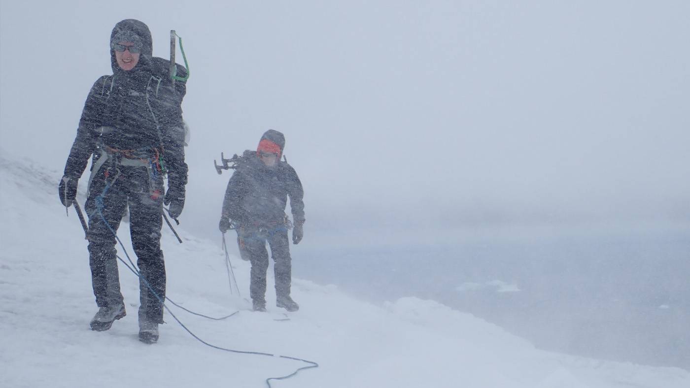
Ascending the southern flank of Mt Michael, we’d roped up for security traversing the crevassed glacier. Conditions deteriorated quickly into a blizzard, however.
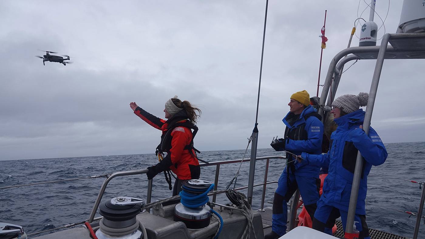
The team launch a small multi-rotor drone to make observations when the ocean was too rough to land ashore.
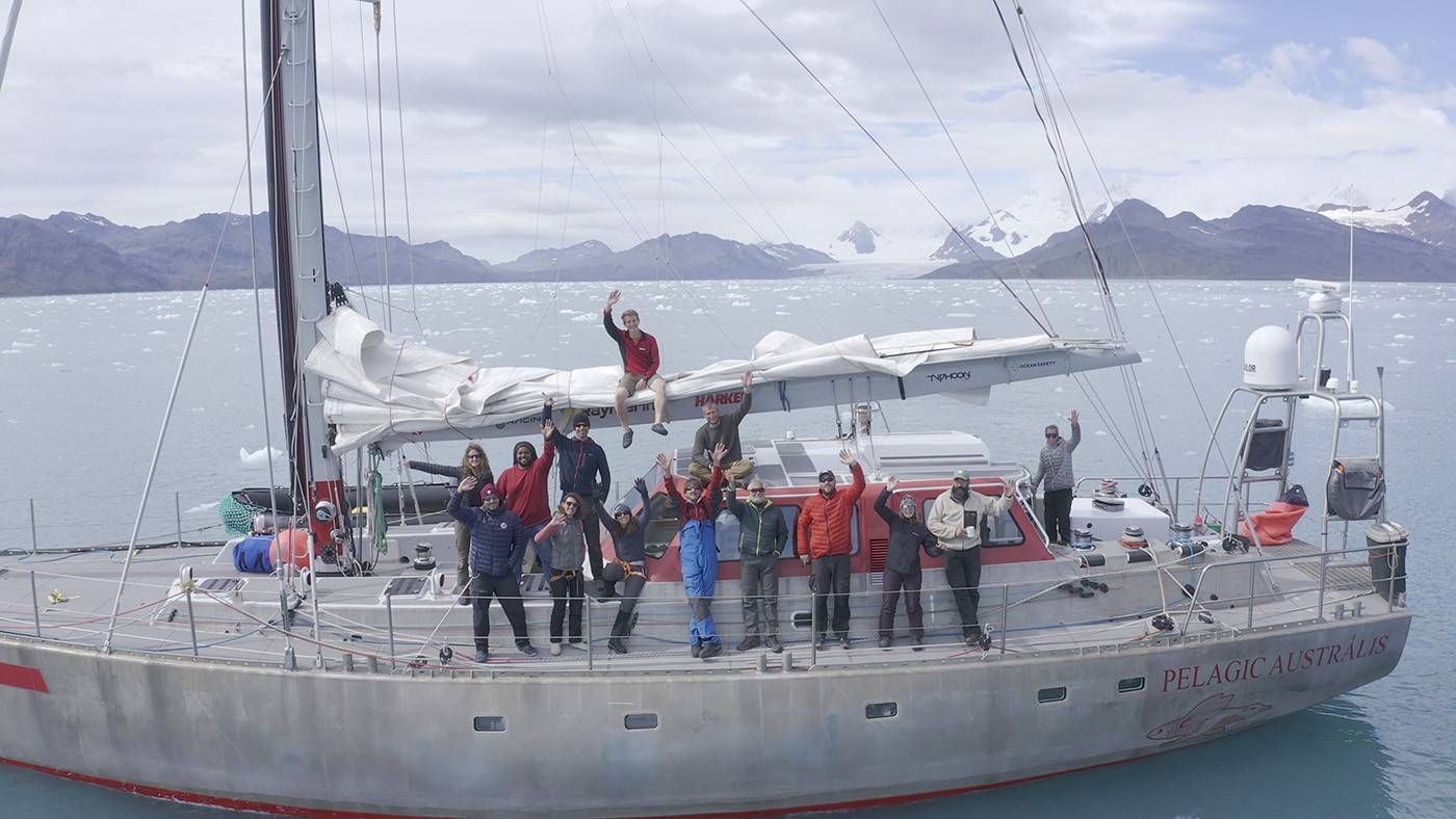
The expedition team aboard the Pelagic Australis. Left to right: Emma Liu, Chris Kobusch, Hamza Yassin, Gemma Clucas, Ted Cheeseman, Jo Feldman, Kieran Wood, Skip Novac, Mario Potocki, Paul Mayewski, Tom Hart, Ruth Peacey, Thomas Geipel, Sophie O’Neill.
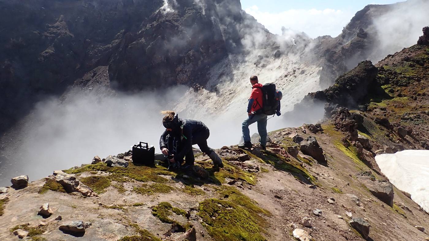
We collected samples of the volcanic gases to analyse back in the laboratory.
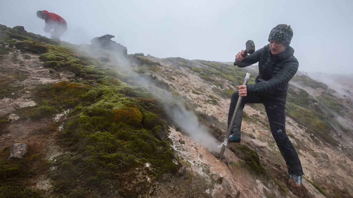
Staring into the crater of Bellingshausen, where strongly degassing fumaroles inside the crater precipitate sulfurous deposits.
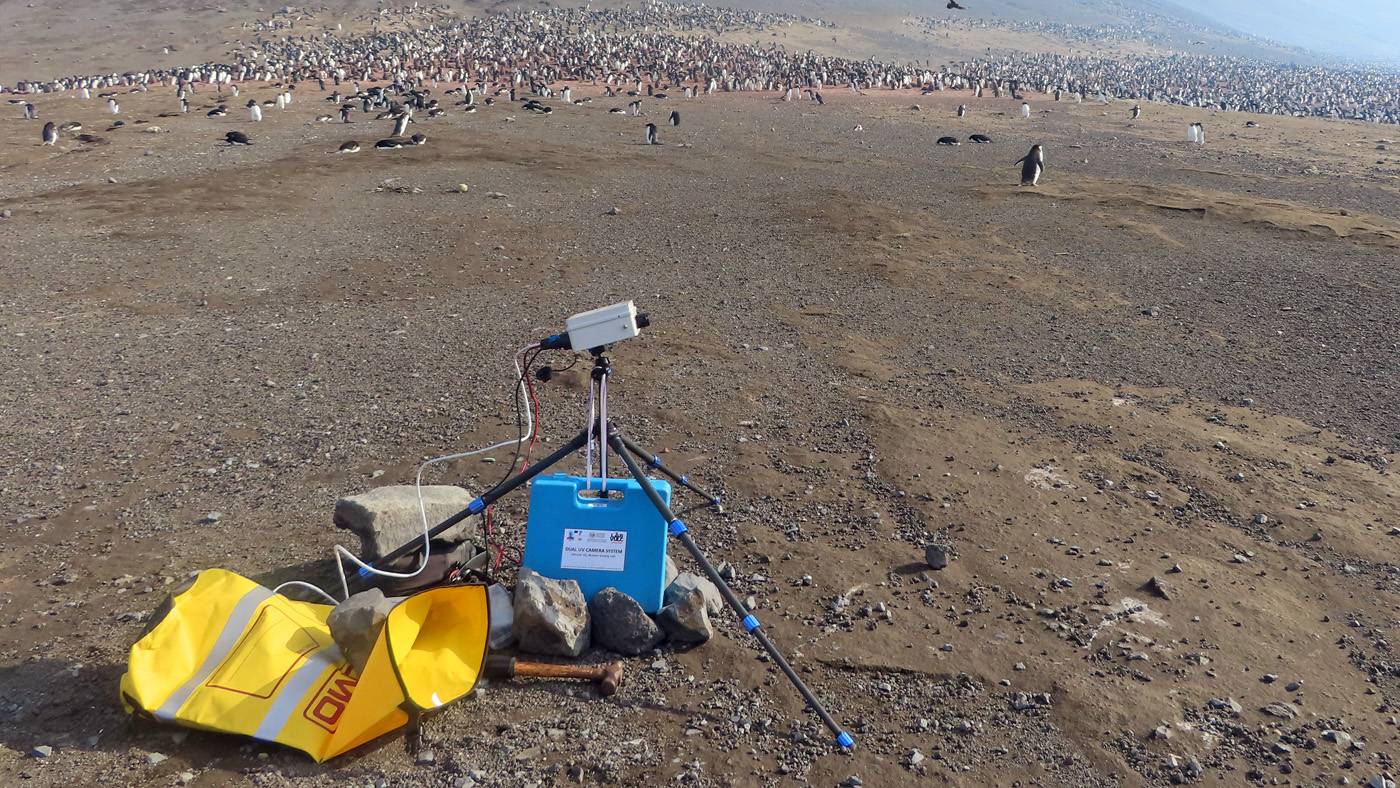
We used a UV camera to measure the emission rate of sulfur dioxide (SO2) from Mt Michael, whilst surrounded by many penguins.
We set sail from Port Stanley in the Falkland Islands on 30 December 2019 aboard the Pelagic Australis, a 23-metre sailing yacht that would be our home for the next five weeks. My aim on this expedition was to study the volcanic processes taking place along the South Sandwich arc, with a focus on characterising the chemistry of the volcanic gases being released. I set out to collect samples and in situ measurements that would constrain the chemical composition and emission rate of active gas emissions and previously erupted lavas. Together with Kieran Wood, we made up the volcanological team. Also in the scientific party were Tom Hart and Gemma Clucas, who collected aerial imagery and penguin faecal samples to study the ecology and genetics of the vast penguin colonies breeding in the SSI; Paul Mayewski and Mario Potocki, who collected snow and ice core samples from glacial ice to investigate the climatic changes preserved in these records; and Ted Cheeseman, a whale ecologist interested in assessing the recovery of whale populations in the South Sandwich Islands following near-extinction by past whaling activities.
Before I left for this expedition, I was warned that we were at the mercy of the weather and should expect to achieve about 10% of what we had planned. With this in mind, I can confidently call the expedition a huge success. We made six shore landings on four islands, collected aerial imagery that will enable the generation of new topographic models, collected almost 40 kg of lava and ash samples, and acquired gas measurements and bag samples from three actively degassing volcanic islands. On top of this, the other scientific teams had their own success stories. I’m determined that this will not be the last time I venture to the South Sandwich Islands, as there is so much left to learn about this unique volcanic environment. You can read the full blog article on the EGU website
Related Links:
- Geochemistry, Mineralogy, Petrology & Volcanology | Five hundred miles from civilisation: Exploring active volcanism in the South Sandwich Islands - EGU Blogs
- Dr Emma Liu's academic profile
- Follow Emma on Twitter
Outreach: GeoBus is off the road and onto the Internet by Dr Amy Edgington
The global COVID-19 pandemic has changed the team’s trajectory, enforcing a pause from normal activities and a switch to a new mode of creating online content.
The GeoBus is a mobile outreach programme that brings free interactive Earth Science workshops into the classroom. From climate change to fossils, the workshops highlight the numerous and diverse links between Earth Science and the school curriculum. The global pandemic we are all facing quickly put the brakes on the mobile GeoBus and the team have been working hard to adapt and provide support to the many home-schooling families and students all across the country.
At the end of March, a new page was premiered on the GeoBus website; GeoBus Resources. On this page you will find an extensive list of free online resources based around the workshops that we usually offer to schools. As of writing there are already sixteen individual activities aimed at the primary school curriculum including earthquake themed word searches, space themed games and recipes to create erupting volcanoes in your kitchen. Plus, the brand-new resource packs can be used to form the basis of fully structured science lessons on the subjects of rocks and fossils. GeoBus is not stopping there, wheels are rolling (and keyboards are tapping) on new primary resources including activity packs on climate change, volcanoes, space and more.
Beyond the primary curriculum, both Key Stage 3 and GCSE resources are underway and will be uploaded onto the site soon including structured activity packs based on core GCSE topics. As a preview of the upcoming GCSE Earthquake Activity Pack, put your geophysics skills to the test and follow the instructions below to build your own seismometer.

You will need: A cardboard box, disposable cup, sticky tape, coins, pen, string, scissors and paper.
- Step 1: Take your cardboard box and turn it on its side so that the opening is at the front, or take a large cereal box and cut off the front panel.
- Step 2: Cut a small hole in the bottom of a disposable cup, large enough that the tip of a pen can poke through.
- Step 3: Secure a piece of string to either side (using sticky tape).
- Step 4: Make two holes in the top of your box and thread the two pieces of string (attached to either side of your cup) through the holes in the top of the box and secure using sticky tape. You will need to make sure the cup hangs low enough for the pen to be able to reach the base.
- Step 5: To keep the pen and cup steady, add coins to the cup to weigh it down (this can also be used to keep the pen upright).
- Step 6: Cut two slits in the sides of your box (so you can thread a strip of paper through).
- Step 7: Finally thread some paper through the slits at the side of your box such that your pen rests on the paper. In our experience, you may need to cut your paper into long strips – but that all depends on the size of your box!
Your seismometer is ready to go. Slowly pull the piece of paper past the pen. The pen will begin to draw a straight line. Ask someone to simulate an earthquake by shaking the box forward and back (make sure you keep pulling the paper past the pen as this happens). Your pen will begin to shake and draw waves on your paper. This is essentially how a seismometer works too but instead of someone shaking the box, it’s the seismic waves produced in an earthquake.

If you’d like to keep updated with new resource releases, Earth science experiments or share your homemade seismometers then follow us on twitter @GeoBus_UCL or check out the GeoBus London resources webpage www.geobus-london.org.uk/schoolresources.
Press Release: The right dose of geoengineering could reduce climate change risks.
Injecting the right dose of sulphur dioxide into Earth’s upper atmosphere to thicken the layer of light reflecting aerosol particles artificially could reduce the effects of climate change overall, according to UCL and Harvard researchers.
Stratospheric aerosol geoengineering is the idea that adding a layer of aerosol particles to the upper atmosphere can reduce climate changes caused by greenhouse gases such as carbon dioxide. Previous research shows that solar geoengineering could be achieved using commercially available aircraft technologies to deliver the particles at a cost of a few billion dollars per year and would reduce global average temperatures. However, the question remains whether this approach could reduce important climate hazards at a regional level. That is, could it reduce region-by-region changes in water availability or extreme temperatures?
Results from a new study by UCL and Harvard researchers suggest that even a crude method like injecting sulphur dioxide in the stratosphere could reduce many important climate hazards without making any region obviously worse off. The findings, published today in Environmental Research Letters, used results from a sophisticated simulation of stratospheric aerosol geoengineering to evaluate whether the approach could offset or worsen the effects of climate change around the world. How these effects differed under different temperature scenarios was also tested.

Figure: The distribution of climate anomalies under the full geoengineering scenario (Full-GLENS), half-warming geoengineering scenario (Half-GLENS) and the RCP8.5 greenhouse gas emission scenario relative to the 2010-2030 baseline. Annual-mean surface air temperature (T, a), maximum annual surface air temperature (Tmax, b), Annual-mean precipitation minus evaporation (P-E, c) and maximum annual precipitation rate (Pmax, d) anomalies are shown for RCP8.5 (red), Full-GLENS (blue), and Half-GLENS (purple). The 1-99% range of the distribution is shown by thin lines, the 5-95% range by thicker lines, the interquartile range by the box and the median by the white vertical line. Results are weighted by land area excluding Greenland and Antarctica.
The team found that halving warming by adding aerosols to the stratosphere could moderate important climate hazards in almost all regions. They saw an exacerbation of the effects of climate change in only a very small fraction of land areas. Lead author, Professor Peter Irvine (UCL Earth Sciences), said: “Most studies focus on a scenario where solar geoengineering offsets all future warming. While this reduces overall climate change substantially, we show that in these simulations, it goes too far in some respects leading to about 9% of the land area experiencing greater climate change, i.e. seeing the effects of climate change exacerbated.
“However, if instead only half the warming is offset, then we find that stratospheric aerosol geoengineering could still reduce climate change overall but would only exacerbate change over 1.3% of the land area.” The team emphasise that solar geoengineering only treats the symptoms of climate change and not the underlying cause, which is the build-up of CO2 and other greenhouse gases in the atmosphere. It should therefore be considered as a complementary approach to emissions cuts as a way to address climate change.
The study is a follow-up to a paper published last year in Nature Climate Change* showed similar results when solar geoengineering was approximated by simply turning down the sun. That prior study begged the question: would the results hold up with a more realistic simulation using injection of sulphur dioxide, the simplest known method of solar geoengineering.
“Our results suggest that when used at the right dose and alongside reductions in greenhouse gas emissions, stratospheric aerosol geoengineering could be useful for managing the impacts of climate change. However, there are still many uncertainties about the potential effects of stratospheric aerosol geoengineering and more research is needed to know if this idea is truly viable,” added Dr Irvine.
The team used data from the Geoengineering Large Ensemble Study, which used a sophisticated climate-chemistry model to simulate the climate response to a hypothetical deployment of stratospheric aerosol geoengineering. In this model study, sulphur dioxide was released at different latitudes in the Tropics to produce a layer of aerosols tuned to keep temperatures steady under an extreme global warming scenario. The researchers focused on changes in mean and extreme temperature, changes in water availability and changes in extreme precipitation, i.e. climate variables that determine key climate risks.
Previous work suggested that stratospheric aerosol geoengineering could lead to a substantial weakening of monsoons and an intensification of drought. However, the authors found that in those regions where halving warming with stratospheric aerosol geoengineering exacerbated change, it increased water availability rather than reduced it. This suggests that concerns that stratospheric aerosol geoengineering could lead to aridification and drought could be misplaced.
Co-author, Professor David Keith (Harvard’s Engineering and Applied Sciences and Kennedy school), said: “Early research with climate models consistently shows that spatially uniform solar radiation modification could significantly reduce climate risks when combined with emissions cuts. But, should we trust the models? Uncertainties are deep and no single result is trustworthy, but this paper is a step towards more realistic modelling from injection to regional impacts.” The team are now researching the projected effects of stratospheric aerosol geoengineering on the water cycle in more depth to try to understand the potential benefits and risks to society and ecosystems. Original article.
Related Links:
- Research paper in Environmental Research Letters
- Research paper in Nature Climate Change
- Dr Peter Irvine's academics profile
Events: WiES 2020,Celebrating Women in Earth Science - CANCELLED due to coronavirus pandemic.

We have invited female scientists in paleoclimatology, geophysics, geology, volcanology and more. We also had plans to invite school students to the conference, giving them an insight into the varied routes within Earth Sciences and provide them with role models that may inspire them to continue studying STEM based subjects to a higher level. The aim of the conference was to highlight the incredible research being conducted by women across the globe, cultivate new collaborations, and inspire the next generation of Earth scientists.
PhD News: The Sixth Snow Science Winter School in Col du Lautaret, France by Robbie Millet. @RobbieMallett
Snow is the most reflective and thermally insulating natural material on earth. Around one third of the earth is covered by it every year, so there are lots of potential study sites! But if you want to really learn about the fastest changing land surface on the planet, you need to go to the annual Snow Science Winter School.
As well as being amazingly beautiful, snow is complex. Initially made of individual flakes, it rapidly turns into a huge, layered and interconnected ice structure as the flakes bond together. This sparse lattice gives snow porous properties and allows water vapor to flow through the structure; this geometry and flow forms the basis of snow science. Snow scientists study mountain avalanches, surface hydrology, polar ecology and climate; once a year grad students from these fields gather for the Snow Science Winter School. Funded by the Finnish Meteorological Institute, the Swiss Avalanche Research Institute and the French Weather Service, the week long school brings twenty-four grad students into the mountains for a crash course on measurement, modelling and remote sensing of snow. This year the school was based at the University of Grenoble’s 2100m high research facility at Col du Lautaret in the French Alps.

On the first morning of the school we were in the field digging snow pits and describing what we found. Tuesday morning featured rotating bases run by the school’s lecturers. Each base had its own snow measurement and associated instruments. We then embarked on a project, spending two days in the field at different sites. My group’s task was to characterize the snow's vertical structure at two sites and compare it with the output of the French met-office model, CROCUS. On the first project day we experienced persistent falling and blowing snow, which meant that we had to periodically re-dig our pit and clean its wall. Fortunately the second day had clear skies and we were in the sun by lunchtime. Because we worked more quickly as a team having practiced the day before, the mood was much more relaxed and we finished early. Other projects focused on site-level horizontal variability of key snow properties, and uncovering the history of the pit before comparing their reconstructions to weather data.
On Friday morning we wrote up our results and presented them to the school. We were finished by 3pm, in time for a group trip to the local spa - a very European activity. Suitably recovered after a tough week of information cramming and pit digging, we gave the successful snow school the celebration it deserved. Read the full article The Sixth Snow Science Winter School in Col du Lautaret, France
Related Links:
Alumni News: Florent Fayolle, MSc Geoscience 2019 graduate was awarded the Dennis Curry Prize for the "outstanding MSc dissertation"
I have recently graduated top of the class in an MSc Geoscience at UCL. My research project focused on the study of Eocene and Miocene planktonic foraminiferal microfossils. From this accomplishment, I was awarded the Curry prize for the best MSc Dissertation by the Geologists’ Association. I am also in the process of publishing one data report with the International Ocean Drilling Program (IODP) and a scientific paper with the Journal of Systematic Palaeontology, both works co-authored and supported by professor Bridget Wade.

My MSc research project has marked the beginning of a promising scientific career on marine Micropalaeontology. After my graduation, I chose to do research in a non-academic environment for a year and expand my skills to Palaeoclimatology. However, my plans will be affected by COVID-19 and the job prospects uncertainties. I was invited by the British Antarctic Survey to take part in the UK Polar Horizons Project and gain work experience with the Ice Dynamics and Paleoclimate team. Also, last February I had the chance to give a presentation at the Foram Fun Day Annual Meeting at UCL, a meeting that was attended by recognised micropaleontologists. I will be soon attending two conferences, including the UK IODP Annual Meeting at the Natural History Museum and the Climate and Biotic Events of the Paleogene (CBEP 2020) in Bremen Germany.
This astonishing year at UCL wouldn’t have been possible without the fantastic support from my supervisor Professor Bridget Wade. With my interest spanning multiple areas, including Palaeoclimatology using marine microfossils and the study of glaciers, I am currently exploring potential PhD options across the UK and the US.
Image: Florent Fayolle at the UCL poster presentation on the 18 September 2019
Further readings:
Fayolle, F. & Wade, B.S., submitted. Data report: Miocene planktonic foraminifera Dentoglobigerina and Globoquadrina from IODP Sites U1489 and U1490 (Expedition 363). International Ocean Drilling Program.
Fayolle, F. & Wade, B.S., in preparation. The evolution of planktonic foraminifera Dentoglobigerina. Journal of Systematic Palaeontology.
Resources:
Newsletters:
Spring 2019 | Autumn 2018 | March 2018
Department history:
Geology at UCL - A brief history.