 Close
Close

SpaceTimeLab’s mission is to generate actionable insights from geo-located and time-stamped data for government, business and society.
Current Projects
- Alexa Prize TaskBot Challenge (2021 - present)
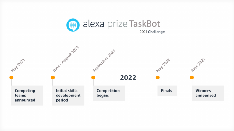
Alexa Prize TaskBot Challenge is a year-long competition and the first conversational AI challenge to incorporate multimodal (voice and vision) customer experiences. This challenge consists of building a TaskBot to help customers complete complex tasks in two domains, cooking and DIY. The UCL team is named Condita, which stands for “COoking aNd DIw Task-based Agent”, has received $250,000 of funding from Amazon for their participation. Condita in Italian means “seasoned” when written as “condita” or “with fingers” when written as “con dita”.
For more information about this project, please contact Dr Aldo Lipani: aldo.lipani@ucl.ac.uk
- The 100 Cyclists Project (2021 - present)

UCL’s 100 Cyclists Project seeks to understand the factors affecting crash risk in cycling through the analysis of detailed near miss data. 100 participants are being recruited, who will have a specially made sensor unit mounted to their bike to collect video and movement data while they ride. When they experience a near miss, the rider will press a button to store the data. The data will then be analysed at UCL to identify the factors that are commonly associated with near misses.
For more information about this project, please contact Dr James Haworth: j.haworth@ucl.ac.uk
- Virus Watch (2020 - present)
- SpacetimeLab is one of the co-partners devoting 'Virus Watch' which is funded by UK Research and Innovation (UKRI), and by the Department of Health and Social Care through the National Institute for Health Research (NIHR). Professor Andrew Hayward (UCL Epidemiology & Health Care) will lead the ‘Virus Watch’ study to recruit 25,000 individuals and collect data from April 2020 to March 2021. The £3.2 million ‘Virus Watch’ study will investigate the extent of the spread of coronavirus within communities and how social distancing affects the risk of infection.
For more information about this project, please contact Prof Tao Cheng: tao.cheng@ucl.ac.uk
- The Consumer Data Research Centre (2014 - present)
SpaceTimeLab is one of the partners of the Consumer Data Research Centre (CDRC). CDRC was established by the UK Economic and Social Research Council to:
- Contribute towards ensuring the future sustainability of UK research using consumer data
- Support consumer related organisations to maximise their innovation potential
- Drive economic growth
We are bringing together world-class researchers from the University of Leeds, University College London, University of Liverpool and the University of Oxford to offer a range of expert services to a wide range of users.
You can learn more about the project at the CDRC website.
Completed Projects
- INFRARISK (2013 - 2016)
The achievements of the European Union targets regarding energy and socio-economic sustainability are highly dependent on the way risks and vulnerabilities of European operating infrastructure networks and critical assets are minimised against natural extreme events. The INFRARISK project will develop reliable stress tests on European critical infrastructure using integrated modelling tools for decision-support. It will lead to higher infrastructure networks resilience to rare and low probability extreme events, known as “black swans”. INFRARISK will advance decision making approaches and lead to better protection of existing infrastructure while achieving more robust strategies for the development of new ones. INFRARISK proposes to expand existing stress test procedures and adapt them to critical land-based infrastructure which may be exposed to or threatened by natural hazards. Integrated risk mitigation scenarios and strategies will be employed, using local, national and pan-European infrastructure risk analysis methodologies. These will take into consideration multiple hazards and risks with cascading impact assessments.
The INFRARISK approach will robustly model spatio-temporal processes with propagated dynamic uncertainties in multiple risk complexity scenarios of Known Unknowns and Unknown Unknowns. An operational framework with cascading hazards, impacts and dependent geospatial vulnerabilities will be developed. This framework will be a central driver to practical software tools and guidelines that provide greater support to the next generation of European infrastructure managers to analyse and handle scenarios of extreme events. The minimisation of the impact of such events by the supporting tools shall establish optimum mitigation measures and rapid response. INFRASRISK will deliver a collaborative integrated platform where risk management professionals access and share data, information and risk scenarios results efficiently and intuitively.
- Crime Policing and Citizenship (CPC) (2012 - 2016)
The UCL Crime, Policing and Citizenship (CPC) project aims to investigate the relationship between detailed patterns of police activities and the space-time pattern of recorded incidents and public perceptions of crime. The project is being carried out in collaboration with the Metropolitan Police, with support from the UK Engineering and Physical Sciences Research Council (EPSRC).
For more information on the CPC project visit our Website https://www.ucl.ac.uk/cpc/
- Spatio-Temporal Analysis of Network Data and Route Dynamics (STANDARD) (2009 -2012)
UCL together with Transport for London (TfL) work on a 3-year EPSRC-funded research project to investigate spatio-temporal characteristics of data from transport networks. The Spatio-Temporal Analysis of Network Data and Route Dynamics (STANDARD) project encompasses and builds upon a broad range of modelling approaches in spatio-temporal analysis, complexity science and state of the art 3D visualisation.
For more information on the STANDARD project visit our Website http://standard.cege.ucl.ac.uk/workshops/index.htm
- Modelling the Changing Surroundings of Everyday Life (2009 - 2012)
Understanding travel behaviour and travel demand is of constant importance to transportation communities and agencies in every country. Modelling this kind of activity on the aggregate scale is very important for applications like measuring time expenditures and quality of life, tourist activity and environmental issues. Nowadays, attempts have been made to automatically infer transportation modes from positional data, such as the data collected by using GPS devices so that the cost in time and budget of conventional travel diary survey could be significantly reduced. Some limitations, however, exist in the literature, in aspects of data collection (sample size selected, duration of study, granularity of data), selection of variables (or combination of variables), and method of inference (the number of transportation modes to be used in the learning).
This project aims to fully understand these aspects in the process of inference. The work attempts to solve a classification problem of GPS data into different transportation modes (car, walk, cycle, underground, train and bus). We first study the variables that could contribute positively to this classification, and statistically quantify their discriminatory power. We then introduce a novel approach to carry out this inference using a framework based on Support Vector Machines (SVM) classification. We then apply segmentation strategies to identify significant stops that occurred along a person’s track such as home, work, etc. The classification then is subjected to a network matching process that checks whether the identified modes follow their corresponding transport networks to verify the final classification. This project is sponsored by u-blox and EPSRC.
For more information about this project, please contact Prof Tao Cheng: tao.cheng@ucl.ac.uk
- Trust in Web GIS (2007 - 2011)
Attesting to the powerful capabilities and in technology trends, many scholars envisioned the consolidation of Geographic Information Systems (GIS) into vital tools for disseminating spatial information, that are presently used to inform, advise and instruct users in several contexts and to further engage citizens in decision-making processes that can impact and sustain policy development. Interaction with these applications incorporates risk and uncertainty, which have been repeatedly identified as preconditions in nurturing trust perceptions, and which instigate a user’s decision to rely on a system and act on the provided information.
In a four-year project carried out in collaboration with Arup and with the support from the UK Engineering and Physical Sciences Research Council (EPSRC), Artemis Skarlatidou, used a multidisciplinary research approach derived mainly from the fields of Human-Computer Interaction and Risk Communication, to identify how non-experts' trust perceptions are formed when they interact with environmental Web GIS applications, but also how information about nuclear waste should be communicated to lay people to improve public understanding and trust. The findings supported the development of the PE-Nuclear tool; a Web GIS application to inform lay people in the UK about the site selection of a nuclear waste repository.
In a different project, also funded by the UK Engineering and Physical Sciences Research Council (EPSRC), we use the same approach to identify how non-experts' trust perceptions are formed when they interact with public crime Web GIS. One part of this research focuses on identifying the user needs and expectations when they interact with different types of crime data at different scales and for different purposes, while the other part aims at building novel crime visualisation approaches which are evaluated for their perceived trustworthiness with non-expert users.
For more information about this project, please contact Dr Artemis Skarlatidou (a.skarlatidou@ucl.ac.uk) or Prof Tao Cheng: (tao.cheng@ucl.ac.uk)