Open research dataset released by CEGE’s 3DIMPact group
2 August 2019
With sponsorship from the Centre for Digital Built Britain, Dr Jan Boehm, Head of CEGE’s Geomatics section, and PhD student David Griffiths, have released a high-quality public open dataset, intended to help accelerate research in point cloud processing.

Advancements in autonomous driving, urban mapping and remote sensing currently make point cloud processing a very relevant and popular field. As deep learning becomes a more prominent approach for automatic classification of point cloud data, a key bottleneck that occurs is the amount of high quality 3D training data available, especially when compared to 2D images. One potential solution is the use of synthetic data; however, the ability for models to generalise from synthetic data to real world data has thus far been poorly studied for point clouds.
To rectify this issue, Dr Jan Boehm, programme director of Geospatial Sciences (Building Information Modelling) MSc, and David Griffiths, whose PhD research has focused on image and point cloud segmentation/classification using machine learning techniques, have created dataset SynthCity. The project has been sponsored by the University of Cambridge’s Centre for Digital Built Britain, under an Innovate UK grant. SynthCity was officially released online on 31 July 2019.
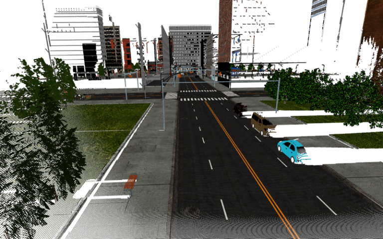
David states: “SynthCity is a 367.9m point synthetic full colour mobile laser scanning point cloud. Every point is assigned a label from one of nine categories. We wanted to accelerate research in this area, and by making SynthCity public and open, we intend for our dataset to allow researchers to better understand the potential for synthetic point cloud data.”
Dr Boehm noted: “This is the first synthetic large-scale mobile LIDAR training dataset. It is the first crucial step for developing systems based on machine learning to automatically detect and identify objects. Urban asset owners and stakeholders will be able to tag assets fully automatically, and at a large scale.”
Both Dr Boehm and David are part of 3DIMPact, a research group in the Geomatics section of UCL Civil, Environmental and Geomatic Engineering (CEGE), which focuses on 3D Imaging, Photogrammetry, Metrology and Applied Coordinate Technologies. The group carries out a wide variety of scientific and applied research on high-quality imaging and modelling, and has links to other UCL initiatives, including UCL Robotics. Other recent 3DIMPact projects have included the integration of historical BIM data and 3D GIS data for documentation and restoration of historical monuments in Jeddah, and photogrammetric analysis of the Queen’s Staircase ceiling at Hampton Court Palace.
Links
Please note, some links lead to external websites.
- UCL Civil, Environmental and Geomatic Engineering
- Centre for Digital Built Britain
- Innovate UK
- Dr Boehm’s CEGE profile
- David Griffiths’ LinkedIn profile
- Geospatial Sciences MSc routes programme page
- SynthCity website
- 3DImpact webpage
- 'SynthCity: A large scale synthetic point cloud' paper
- UCL Research Data Repository: SynthCity
Image
- Credit: David Griffiths.
- Caption: Example scene of the SynthCity dataset.
 Close
Close

