 Close
Close

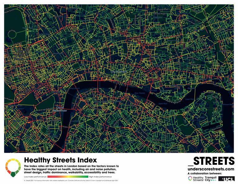
Creating an index of healthy streets in London
The Healthy Street Index, developed at UCL, gives a measure of a street’s ‘healthiness’ and is helping people to choose places to live, travel routes and is informing more sustainable town planning.
17 August 2022
The quality of our street environments is crucial to our health and wellbeing. Having access to open space, safe pedestrian routes and clean air are all beneficial, but without local knowledge, identifying ‘healthy’ streets can be a challenge.
A team at UCL including Dr Ashley Dhanani and Dr Nicolas Palominos (both UCL Bartlett School of Architecture) has developed city-scale indicators of how healthy streets are from the perspective of people using them, which together define a healthy, sustainable welcoming environment for all.
““The index gives a good overall indication of key factors that determine the appeal of streets for walking, cycling and spending time in.”
“Our homes are important to us and the quality of the surrounding street environments is an important factor in ensuring our home can provide the positive environments that help us to live well,” explains Dr Dhanani.
The Healthy Streets Index combines datasets for features such as noise, air quality, traffic, pavement space and public transport connectivity. Dr Dhanani and Dr Palominos worked with UCL experts in public health, urban planning, and environmental data science, as well as external project partners Tranquil City and Healthy Streets Ltd.
The index was developed using GIS techniques to validate and combine key datasets. The data sets are each weighted depending on how important they are in making streets appealing for people.
“Although it is impossible to reflect individual’s perceptions and experiences of a street, the index gives a good overall indication of key factors that determine the appeal and sustainability of a street for walking, cycling and spending time in,” Dr Dhanani says.
Every street across greater London has now been scored from 0 to 100 based around the ten Healthy Streets indicators, including ‘easy to cross’, ‘places to stop and rest’ and ‘people feel relaxed’. Interactive maps that show the street ratings for the whole of Greater London are available, with maps for other cities planned.
“The Healthy Streets Index provides an easily understandable universal rating of the street environments that surround each home,” says Dr Dhanani.
Previously, the information provided by the Index could only be obtained by spending time in an area or by consulting multiple sources of data. Now, individuals can use the accessible online index to help them choose how to travel to work and where they may want to live.
It is also helping city planners and developers to evaluate potential development sites and to identify areas that require investment to improve the quality of the street environment.