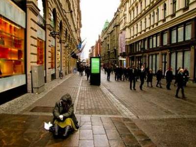
Helsinki is located on the Northern shore of the Gulf of Finland in the Eastern portion of the Baltic Sea, and is comprised of numerous bays, peninsulas and islands. Covering an area of 930.8 km squared with 559,046 inhabitants (Men: 260,573 l Women: 298,473), it is the largest city in Finland. Compared to other cities in Europe, Helsinki had a medium to low population density with 4321 inhabitants per km squared in 2003 - 2006. Yet, within the city of Helsinki, the population density varies substantially from the densely populated inner-city areas to the sparsely populated islands, such as Seurassaari, Korkeasaari and Santahamina.
Helsinki is surrounded by two other cities, Espoo and Vantaa, which together form the Helsinki Metropolitan Area, home to over one million residents. This makes the Helsinki Metropolitan Area the European Union's northernmost urban area. Compared to Western and Southern European capitals, Helsinki has a low immigrant population of 7.3%, as of 2005. Among the cities shown in the INEQ-CITIES Atlas, Helsinki has the highest proportion of employed working-aged adults with an activity rate of 78.9%. Half of Helsinki's workforce is employed in the service sector (50%), whilst 35.4% are employed in social services, and 13.3% in industry and manufacturing.
- City Profile
-
Helsinki has a specific demographic profile, defined by a high participation rate in the labour market and a low immigration rate. Demographic figures collected by the City of Helsinki, Urban Facts Bureau in 2004 are shown below:
- Population aged 0 - 14: 14.5%
- Population aged 65 and older: 13.8%
- Population aged 16 - 64 in the labour market: 78.9%
- Unemployment: 9.1%
- Immigrant population: 7.3%
- Methods
-
Socio-economic and mortality analyses were conducted at a small area-level within each city. The maps of Helsinki represent 94 Statistical Wards. Data from the 2000 - 2009 National Registers were used to obtain the population size per small area.
Small areas with 1000 inhabitants or less were combined with neighbouring areas for confidentiality purposes. Small areas located in Southern Helsinki that consist mainly of islands, including the military island of Santahamina, are sparsely populated and thus were excluded from the analysis. The INEQ-CITIES research of Helsinki is based on these figures.
The table below shows the estimated population size per Statistical Ward by first, second (median) and third quartiles, based on the 2004 figures from Statistics Finland.
Population Size per Small Area, Helsinki Men Women First Quartile
1,410 1,524 Median 2,351 2,681 Third Quartile
3,642 4,368 - Socio-Economic Indicator Maps
-
Social inequalities were examined using markers of deprivation to assess geographical segregation according to socio-economic characteristics. Find out more about socio-economic inequalities within Helsinki by viewing area-level maps of Socio-Economic Indicators of:
Area-level maps of manual workers are not available for Helsinki.
- Mortality Maps
-
Mortality ratios were examined for all-cause mortality and disease-specific mortality, separately for men and women. Please note when interpreting the mortality maps of Helsinki it should be taken into account that maps of some causes of death (e.g. Alzheimer's disease, dementias, and to some extent drug related deaths) may reflect the location of long-term care establishments for elderly people and care and housing establishments for drug addicts and alcohol abusers. For help in identifying the small areas on the maps, please download the area classification map from Statistics Helsinki (PDF).
Find out more about health inequalities within Helsinki by viewing area-level maps of:
- Resources
-
For further information about health inequality and the INEQ-CITIES research conducted in Helsinki, please go to:

 Close
Close


