 Close
Close

Workshop: Tools & Methods for Post Disaster Reconnaissance Missions
20 October 2021, 2:30 pm–5:30 pm
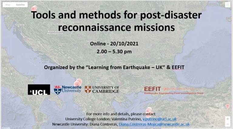
The EPSRC sponsored LfE Project, running since 2018, aims at improving the understanding of earthquake impacts, response, and recovery through targeted data gathering in earthquake reconnaissance and recovery missions. A major objective of this project is to advance methods and tools to collect, interpret, exploit and disseminate this data. Our tools and methods have transitioned from physical field deployment to the support of hybrid or remote field missions, which might well become the "new-normal" practice.
This event is free.
Event Information
Open to
- All
Availability
- Yes
Cost
- Free
Organiser
-
Prof Dina D’Ayala, Prof Tiziana Rossetto, Dr Valentina Putrino
Webinar Topics
- use of social media (typically accessed before the mission)
- reconnaissance tools (physical, electronics, data acquisition tools, used during missions)
- data storage, visualisation, and exploitation (typically during and after missions, and associated legacy issues)
Workshop Agenda
Welcome & Intro: Prof Dina D'Ayala - Co-Director of EPICentre: "The need for Reconnaissance Missions" (2.00 pm)
Theme "Virtual Reconnaissance": Erica Fisher (2.05 pm)
Theme "Tools and Methods for damage assessment" (2:10 to 2.35 pm)
• Valentina Putrino
• Tracy Kijewski-Correa
• Vitor Silva & Anirudh Rao
• Shenglin Lin
• Julia Crummy
Discussion (2:35 to 2.50 pm)
Break (2:50 to 3:00 pm)
Theme "Visualisation, storage & exploitation of data" (3:00 to 3:20 pm)
• Maurizio Pollino
• Sonia Giovinazzi
• Irina Dallo
• Anawat Suppasri
Discussion (3:20 to 3:35 pm)
Break (3.35 to 3.45 pm)
Theme "Applications & Case Studies" ( 3:45 to 4.10 pm)
• Ella Melianda
• Ahmet Yalciner & Guney Dogan
• Diana Contreras Mojica & Sean Wilkinson
• Basbug Erkan
• Yolanda Alberto
Panel discussion & Q&A (4:10 to 4.40 pm)
Concluding Remarks: Tiziana Rossetto - Co-Director of EPICentre (4:40 to 4.45 pm)
About the Speakers
Yolanda Alberto
Researcher at National Research Center for Integrated Disaster Risk Management (CIGIDEN)
- Reconnaissance of the 2017 Puebla-Morelos Earthquake
Earthquake reconnaissance is usually carried out soon after the event, following rescue activities. Nevertheless, some geotechnical evidence might be lost during recovery actions. Virtual reconnaissance can be useful to identify ground failure and loss before such actions. The 2017 Puebla-Morelos Earthquake also affected Mexico City. A Earthquake Engineering Research Institute team conducted a virtual reconnaissance relying mainly on social media for two weeks following the earthquake. This information was then used as input for field reconnaissance teams, including one from the University of Tokyo, which conducted microtremor measurements in Mexico City to characterize the earthquake response of ground and structures in the different soil types. The information gathered in the virtual stage was useful to identify the earthquake effects, from other causes. Observations in the field were more focused and provided more insight using the virtual survey information as a basis.
Julia Crummy
Volcanologist at the British Geological Survey (BGS) at Researcher
- Development of BGS▪SIGMA for Disaster Risk Reduction: a toolkit for the collection of pre- and post-disaster data
The British Geological Survey SIGMA system provides an integrated toolkit for recording, manipulating and interrogating data using GIS and a relational database. We are developing a suite of data collection modules for the BGS▪SIGMA platform to allow users to capture pre- and post-disaster data, by recording observation points, photographs, sketches, samples and comments directly into a GIS, with no limit to the number of observations. These data is stored in database and linked to a single point in the GIS. Users can re-visit the site, and add new data, enabling the assessment of cumulative impacts and damage over time as, for example, a volcanic eruption progresses with repeated ash fall. The BGS▪SIGMA for DRR toolkit will enable to integrate field data with other geospatially referenced datasets to build a picture of vulnerability, exposure, hazard extent, damage and impacts almost instantaneously, to aid in planning and preparedness in disaster-prone areas, and facilitate post-disaster recovery.
Irina Dallo
PhD Student at Swiss Seismological Service (SED)

- Tools and methods to explore how to best communicate event-related earthquake information in a multi-hazard context
Why does it matter to involve relevant stakeholders in the design process of communication products/services? This allows to co-design communication products/services together with experts from different fields and to involve end-users throughout the process, ensuring that the products/services fulfil their needs. The presentation introduces the two concepts “transdisciplinary research” and “design thinking”. A case study illustrate practical application of these two concepts. This will focus on communication of event-related earthquake information in a multi-hazard context. To this end, a mixed-method approach is used to gather different perspectives and to understand the end-users’ thinking behind their needs. This process has to be iterative as the end-users’ needs and institutional environment change over time. Results show which hazard overviews and hazard messages are best understood and preferred by the end-users, and which ones trigger them to take actions.
Burçak Başbuğ Erkan
Academic Partnerships Director Institute of Civil Protection & Emergency Management (ICPEM) and Associate Professor of Statistics at Middle East Technical University (METU)
- Earthquakes in Turkey: Reconnaissance for 2011 Van and 2020 Izmir
Turkey experiences various magnitude of earthquakes due to its geological location. 17 August 1999 Marmara Earthquake became a milestone in the country’s earthquake preparedness, response and recovery phases. Since then, the most significant earthquake to test the change in earthquake studies became the 23 October 2011 Van Earthquake. This work will present the findings of the reconnaissance study to Van just one month after the earthquake. Another earthquake hit the Aegean coast of Turkey, the city of Izmir, on 30 October 2020. As the earthquake occurred during the Covid-19 pandemic, the impact and observations are very important to follow for future preparedness and resilience strategies. Moreover, there was a tsunami, which hit the coast of Seferihisar district following the Izmir earthquake. Fortunate or unfortunate, the author had an opportunity to visit both locations after the disasters. This presentation will share some findings from Van 2011 and Izmir 2020 field missions.
Erica Fischer
PhD, PE, Assistant Professor of Civil and Construction Engineering at Oregon State University.
- How virtual reconnaissance can support multi-disciplinary in-field reconnaissance
Virtual reconnaissance is the act of gathering information after an extreme event through virtual means. This information could be diverse: locations of geotechnical damage (landslides, rockfalls, etc.) or structural damage (collapsed or partially collapsed buildings), cultural data, damage due to previous events, information on the revised codes in a region after a disaster. The Virtual Earthquake Reconnaissance Team (VERT) of the Earthquake Engineering Research Institute (EERI) has demonstrated that when virtual reconnaissance is multi-disciplinary, the reports can highlight interconnectivities between disciplines and systems throughout the affected region (e.g. housing, education, healthcare). This presentation summarizes previous virtual reconnaissance conducted by researchers in a single discipline, and compare the resulting VERT work to demonstrate the effectiveness of multi-disciplinary virtual reconnaissance. The presentation demonstrates how virtual reconnaissance is critical when regions are inaccessible, such as due to the global pandemic, or regional political turmoil.
Sonia Giovinazzi
Researcher and Project Manager at Italian National Agency for New Technologies, Energy and Sustainable Economic Development (ENEA)

Sergio Cappucci
Geologist at Italian National Agency for New Technologies, Energy and Sustainable Economic Development (ENEA)
Maurizio Pollino
Researcher at Italian National Agency for New Technologies, Energy and Sustainable Economic Development (ENEA)
- Potentialities of scenario simulation tools to support emergency response and post-disaster recovery
The contribution will showcase and discuss potentialities of different tools and methods implemented by ENEA in the framework of different international research projects, for enhancing and empowering both the awareness and the post catastrophic emergency actions.
Tools and methods presented will include:
A Web-GIS Decision Support System, CIPCast DSS, that aims to facilitate the collection, integration, dynamic update of ex-ante and ex-post information necessary for coordinating effective and evidence-based emergency management and disaster response activities. CIPCast, enables also the simulation of deterministic scenarios, for a prompt estimation of the possible induced damages on the built environment and the consequent reduced functionality or loss of primary services and community functions. Remote sensing techniques to support the characterization and management of disaster rubbles. Urban planning and geological assessment: correlation between seismic ground-motion amplification and the buildings damage through GIS applications to support a resilient and sustainable post-disaster reconstruction.
Tracy Kijewski-Correa
Leo E. and Patti Ruth Linbeck Collegiate Chair and Associate Professor, Department of Civil and Environmental Engineering & Earth Sciences, and Associate Professor of Global Affairs at Keough School of Global Affairs.
- New Collaboration Models for Documenting Built Environment Performance after Natural Hazard Events: The Structural Extreme Events Reconnaissance (StEER) Network
The Structural Engineering Extreme Events Reconnaissance (StEER) network was founded with the mission to generate new knowledge on the performance of the built environment through impactful post-event reconnaissance. Since its founding, StEER has focused on shifting the US Natural Hazard Engineering (NHE) community’s paradigm from isolated researchers using paper forms to generate proprietary data toward community collaboratives using digital platforms to acquire data that results in open-source products. As part of this shift, StEER has focused not only on efficiently collecting perishable data, but also on ensuring that data is suitable for reuse and discoverable on long-term curation platforms. This presentation will introduce StEER’s event response workflow, its tiered responses engaging field and virtual structural assessment teams, its promotion of data standards for well-documented/quality-controlled data suitable for diverse re-uses, and a summary of some of the impacts achieved using this new collaborative model in recent natural hazard events.
ShengLin Lin
Senior Risk Engineer at GNS Science

- Development and application of the Real-time Individual Asset Attribute Collection Tool
Improving collection and management of data, in post-disaster reconnaissance and in long-term impact assessments, is central to enabling knowledge of such events to be applied to improving community resilience to those disasters. The presentation briefs the development and applications of an integrated framework for capture of data describing pre-disaster physical characteristics and post-disaster damage of assets. The framework, named Real-time Individual Asset Attribute Collection Tool (RiACT) and its associated Asset Repository Web Portal, enables data capture by direct field observations of asset attributes. Experiences and challenges in applying the framework are highlighted through: (1) capture of community data to support the understanding of risk (e.g. a multi-hazard assessment in Viet Nam 2014 and 2018, and (2) collection of damage data following recent events in New Zealand, earthquake and tsunami in Indonesia and Chile in 2018 and 2015, respectively, and tropical cyclone in Fiji 2016).
Ella Melianda
Scientist and Project Manager at Tsunami and Disaster Mitigation Research Center (TDMRC), Teaching Staff Member at the Civil Engineering Department of Syiah Kuala University
- Challenges in conducting post-disaster fieldwork at rural areas under the pandemic Covid-19 situation: A case of School-hubs Resilient Project at the Central Sulawesi of Indonesia in July 2021
Almost three years after the earthquake, tsunami and liquefaction disaster hit the Central Sulawesi Province of Indonesia on 28 September 2018, the post-disaster recovery has been relatively slow. The post-disaster recovery process was at the end of the rehabilitation and reconstruction phase when the Resilient School-Hubs Project team was set on the mission to conduct the post-disaster school building and infrastructure recovery assessment at Palu City, Sigi and Donggala districts. In addition, the pandemic situation of Covid-19 highly accentuated the mission, provoking traveling restrictions for the foreign researchers to join the fieldwork mission with the local partner team. We tackled those challenges by setting up a hybrid mission combining the physical fieldwork with the combined online database and information collections, Google Earth/ Open Street Map, and KoboToolbox, i.e., an online application for data acquisition survey. The selection of schools to visit prior to the fieldwork mission is crucial to prepare the complete fieldwork, ensure accessibility to schools’ campuses, and get respondents. The data acquisition involved physical measurements of the building’s structural and non-structural damage, interview with school administrators, teachers, and students, and conducting a transect walk for the Water Sanitation and Hygiene (WASH) infrastructure in the school campus.
Valentina Putrino
Earthquake Research Analyst at Ariel RE/Honorary Researcher at UCL

Dina D’Ayala
Professor of Structural Engineering at UCL

- The LfE Mobile App: from the main conceptual idea to the field applications
The LfE Mobile App is one of the outputs of the LfE UK Project. The App uses an existing off-the-shelf platform called Device Magic and is built to conduct damage assessment due to earthquake and tsunami during reconnaissance missions. The App is based on a “tier assessment rationale”, whereby the data set for the building survey, is suited to the amount of time the user can spend on site and the level of access to the building. The data collected is hierarchically organised so that there is no need for repetition if more time is available later, whilst guaranteeing that an increasingly detailed level of information is gathered in each successive tier. From its very first conceptual idea to the several applications during past EEFIT reconnaissance missions, this presentation provides an overview of its development to its current standard. The flexibility of deployment in virtual, remote and hybrid conditions will be illustrated.
Anirudh Rao
Seismic Risk Modeller at Global Earthquake Model (GEM)

Vitor Silva
Seismic Risk Coordinator at Global Earthquake Model (GEM)
- Rapid earthquake damage evaluation based on earth observation data and machine learning
A framework for semi-automated damage and loss assessment due to earthquakes and floods from Earth Observation (EO) data and other supplementary datasets, while also leveraging recent advances in machine-learning algorithms, is presented. The framework combines high-resolution building inventory data from OpenStreetMap and other sources with image-processing algorithms for the detection of earthquake damage and flood extents using remote-sensing data processed by the Advanced Rapid Imaging and Analysis (ARIA) team at NASA's Jet Propulsion Laboratory (JPL) and Caltech, along with supplementary geospatial datasets to provide timely estimation of damage and economic losses. These early estimates can potentially be used for financial compensation and to target the distribution of resources geographically and temporally. We examine and compare the damage prediction accuracy achievable using the framework for a few recent earthquakes and the extensibility of the methodology to floods. We close with thoughts on the current state-of-the-art and promising developments in this field in the near future.
Anawat Suppasri
Associate Professor, International Research Institute of Disaster Science, Tohoku University
- Fragility functions and loss functions of tsunamis for supporting disaster preparedness, recovery and reconstruction
The latest research findings including fragility functions of damaged buildings from both seismic and non-seismic tsunamis and loss functions of facilities in port industries which are examples of visualisation of vulnerability data and important for recovery and reconstruction process. Indonesia has experienced several tsunamis triggered by seismic tsunami (the 2004 Indian Ocean tsunami) and non-seismic tsunami (the 2018 Sulawesi tsunami and the 2018 Sunda Strait tsunami). These tsunamis damaged or destroyed coastal buildings and infrastructure and caused considerable loss of life. Therefore, we assessed the empirical tsunami fragility to the buildings inventory of tsunami tsunamis. We also developed loss functions by quantifying damage criteria and downtime for different port industries based on not only the 2011 earthquake but also other earthquakes until 2021. This information will useful for improving accuracy of tsunami risk assessment as well as input information for decision making during emergency response.
Sean Wilkinson
Reader in Structural Engineering at University of Newcastle

Diana Contreras Mojica
Lecturer in Geospatial Science at Cardiff University

- Impacts vs Consequences, can we switch the emphasis
Currently there are a number of methodologies that can calculate estimated economic losses (e.g. CAT models) or even potential deaths (USGS Pager for example) but while these may give a good indication of the severity of the event, different societies will suffer in different ways and currently we have very little understanding of how to estimate this. Recently, social media (SM) has shown the potential to become a valuable tool for quickly collecting large amounts of first-hand data after a disaster therefore help to understand how societies are affected on the ground. However, extracting meaningful information from SM is an ongoing area of research. In this presentation, we present a methodology for interrogating Twitter data with an aim of better understanding how well a society performed in the immediate aftermath of an earthquake and what aspects of that community may have led to positive or negative experiences.
Ahmet Cevdet Yalciner
Ocean Engineering Research Centre, Professor of Civil Engineering at Middle East Technical University (METU)
- Recent Experiences Using New Tools and Real-time Data Sharing in Post Tsunami Field Surveys
Post tsunami field surveys are critical interdisciplinary activities just after the tsunamis, to collect perishable data of tsunami traces, essential to document the tsunami parameters and understand the events in detail. Eyewitness interviews and available media records are helpful to document the extent and variability of inundation. Water heights at specific locations, timing and duration of tsunami surges, flow depth and directions, current speeds, impact on structures and societal impacts on coastal communities need to be well-documented for future mitigation and preparedness. UNESCO’s International Tsunami Survey Team (ITST) Post-Tsunami Survey Field Guide (2014) provide guidance on collecting this information. However, the new techniques and tools in communication and data sharing between survey members at site and remotely, contribute to the success and effectiveness of the post-disaster reconnaissance. The presentation introduces the history, objectives, procedure and method of conducting post tsunami field surveys with new tools for data collection, sharing and discussion among the experts before, during, and after the surveys. The benefits of real-time data sharing and feedbacks from experts not on the site are also discussed.