 Close
Close

Jane Jacobs reloaded: developing a computational approach to urban vitality
18 July 2019
Patrizia Sulis integrates data science and urbanism theory to measure urban qualities and life in cities
Understanding the dynamics of urban life – how people use places - and unveiling the patterns of human presence in space represents a critical topic to explore for urban research. The recent availability of large data sets containing information about human mobility in cities can be exploited to investigate the spatiotemporal patterns of daily urban life, employing them to measure renowned spatial qualities such as urban vitality.
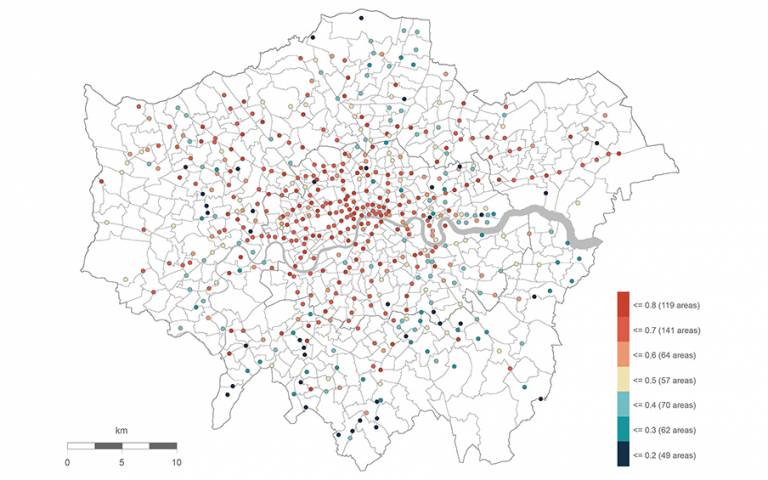
According to Jane Jacobs, the continuity about the presence of people in places and their use over the day is the fundamental characteristic that effectively makes a place vital. Consistently with Jacobs’ view, this work regarded the continuity of human activity in places across time as the essential element to recognise vitality as a spatial quality belonging to a place. Differently from Jacobs’ idea, the computational method proposed in this work converts her qualitative understanding of urban diversity into a metric that effectively measures the variation (diversity) of the daily patterns of people of in cities. This diversity was calculated by three different indices that singularly measure the variation at daily and hourly intervals, for weekdays and weekend days. Together, these indices contributed to defining an overall value for the variation, showing if a place presents continuity or concentration peaks in the presence of people during the day and the week. Data analysis employed information about human mobility sourced from Oyster card and Twitter data, and machine learning techniques adopted from data science.
This work contributed to urban research investigating daily rhythms and dynamics of urban life in cities by proposing a computational method that integrates long-standing urban concepts as urban vitality with new sources of spatial information and cutting-edge techniques adopted from data science. The method contributed to revealing the temporal dimension of daily rhythms and use of places occurring in cities, which represents an additional and critical layer of information to understand. It also demonstrated that it is possible to convert spatial qualities in quantitative metrics that can be applied, also in combination with traditional metrics and tools, to support urban analysis, planning and policies in developing and improving urban space and therefore the life of people living in cities.
This work aimed to show the potentialities of adopting and incorporating computational methods into urbanism research to fellow researchers. It also attempted at bridging the gap between the disciplines of urbanism and urban computing, aiming at a more collaborative and transdisciplinary approach to the common and complex object of research: cities and the urban domain.
This work is part of the doctoral thesis developed by Patrizia Sulis at the Bartlett Centre for Advanced Spatial Analysis. The thesis was successfully defended in March 2019.