 Close
Close

CASA launches Colouring London platform
3 October 2019
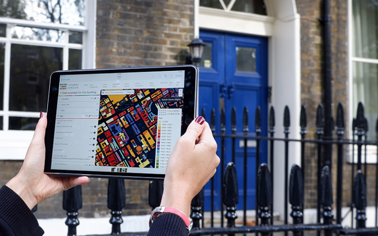
Colouring London is a new citizen science platform that collects, collates, visualises and allows people to download statistical data about every building in London.
The platform was launched on Thursday 3 October at The Bartlett, where Chief Digital Officer for Greater London Authority, Theo Blackwell MBE, introduced the project and emphasised its potential impact as a free source of information about the built environment of London.
Colouring London will enable members of the public to contribute information about the buildings in their city through an easy-to-use visual interface. Buildings on the online map will colour as data are added, gradually colouring the city.
Three core partners, the Ordnance Survey, the Greater London Authority and Historic England, provided initial support and assistance that made development possible. Funding for the project has been secured from Historic England, The Engineering & Physical Sciences Research Council (EPSRC), UCL Innovation and Enterprise, and Innovate UK.
Colouring London will become the go-to source for information about the buildings of London, enabling Londoners, and anyone else who is interested, to access information which has not been freely available from a single source before.
Contributors can to add information across 12 different categories of statistical data: - location, age, land-use, type, size & shape, construction methods and materials, who built and designed it, energy performance, streetscape, whether a public asset, whether a listed or other special planning category, and whether the building is ‘liked’. The platform will present the collected data as coloured maps, allowing users to quickly and easily record and share the physical make-up of their neighbourhoods, boroughs and the wider city.
Polly Hudson, the Colouring London Project Leader for CASA said:
““Colouring London is designed to increase transparency in the planning system by placing instant, free, and easily comprehensible information on London’s buildings in the hands of communities, as well as the broad spectrum of professions and interest groups in the built environment.
The data collected will be relevant to all those involved in the management, construction, planning and conservation of London’s fabric. Data visualizations will provide a free educational resource for residents and schools, and celebrate the richness and diversity of the capital’s buildings and of our collective knowledge of the present and past.”
The project began life as one of the outputs of Polly Hudson’s doctoral research project, built out of a frustration at the lack of open data on UK building stock available for use in urban analysis.
Colouring London has been designed to provide a simple point of access to a wide range of large-scale datasets. By assigning a colour to a range of values, such as the age of a building, users can generate maps to quickly collate and view information in a way that is easily comprehensible and accessible.
The source code for the platform has been made available on GitHub to allow other cities and organisations to create their own projects.
The Colouring London launch takes place as part of Bartlett100, a year-long celebration of the centenary of the naming of Bartlett Faculty of the Built Environment.
Bartlett 100

The launch of Colouring London was part of Bartlett 100, a year-long celebration in 2019 to mark 100 years since the naming of the faculty - find out more.