 Close
Close

ReMap Lima: A Participatory Approach to Mapping
6 February 2014

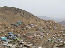
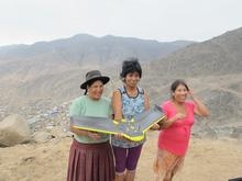
CASA, the Development Planning Unit and Drone Adventures, a Swiss NGO, join local partners in Lima from the 2nd to the 11th of February to map the two case study sites of Barrios Altos and José Carlos Mariátegui. The research team is working closely with Fora Ciudades Para La Vida, and community organisations in these two areas.
This field trip explores grounded applications and the possibilities of cutting edge technologies for mapping and visualization that can contribute to better planning in areas undergoing otherwise 'invisible' change.
Adriana Allen and Rita Lambert (DPU, UCL) with Flora Roumpani (CASA, UCL) are currently engaged in action research in Peru and are updating the research blog daily. Please visit the blog for the latest activities from the project.
The fieldwork is part of a larger project, Mapping Beyond the Palimpsest. The project brings together three departments within UCL: The Centre for Advanced Spatial Analysis (CASA), The Bartlett Development Planning Unit (DPU), and The Bartlett School of Architecture/UCL Urban Laboratory.
It builds upon the DPU research platforms ‘The Heuristics of Mapping Urban Environmental Change’ and ‘Water Justice in Latin American Cities’ and 'Urban Modelling, Data Capture and 3D Visualisation' in CASA.
Taking into consideration the potential ethical, societal, legal and regulatory issues underpinning mapping, the research will apply innovative methods and rapid prototyping – such as 3D mapping, augmented reality, as well as 3D printing - to develop a digital archive in the research sites.