 Close
Close

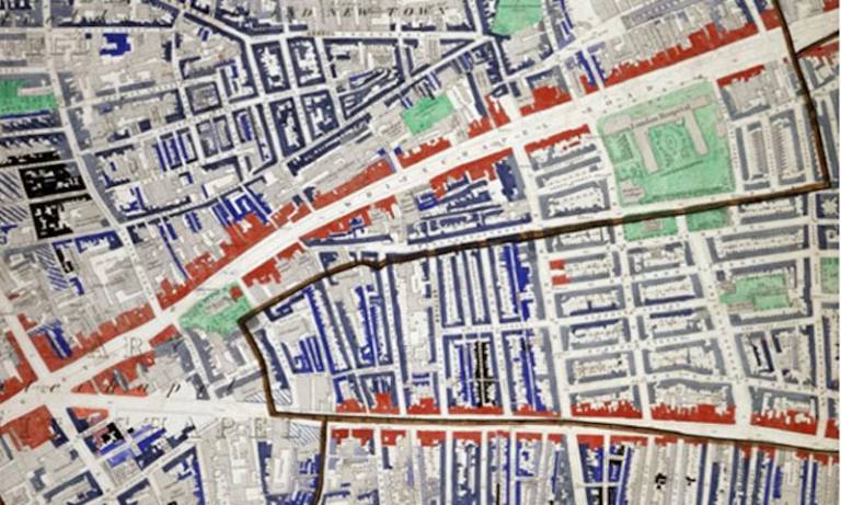
The study of the physical form of the city and its relationship to poverty using space syntax analysis helps to understand the East End of London in the late 19th century.
Research into Space and Exclusion has found a strong relationship between the spatial location of poverty and a relative lack of physical accessibility. Yet, the separation between poor and more prosperous streets was not as sharp as has previously been thought. Although there were pockets of severe deprivation, these were frequently located in close proximity to more affluent areas.
The site also describes earlier research which found that immigrant settlement in a tight cluster offers a platform for participation in the local spatial economy while retaining a strongly supportive local milieu of coreligionists. The research concluded that parts of the East End operated as a mechanism for acculturating immigrants into society through participation in the local spatial economy.
The site uses some of the wide range of historical maps owned by the Museum of London to illustrate how social exclusion is the outcome of an emergent, complex spatial process. The site demonstrates how spatial scientific research can analyse this complexity and shed light on the contribution of urban form to social change through time. It showcases a wide range of resources for socio-economic research using maps.
The site also describes how research using these resources proves that urban layout can itself be associated with urban degeneration and the persistence of spatially-related social problems.
For further information please contact Laura Vaughan on l.vaughan@ucl.ac.uk.
EPSRC Continuation Platform Grant Ref GR/S64561/01
- People
Laura Vaughan BDes, MSc, PhD, FRGS
View Laura's profile
Send Laura an email- Outputs
Vaughan, L. (2008) 'Mapping the East End Labyrinth' in Jack the Ripper and the East End with an introduction by Peter Ackroyd (Ed, Werner, A.). London: Chatto and Windus, 218-237.
The chapter aimed to describe to a general audience the way in which space syntax analysis of the 19th century East End demonstrates the spatial complexity of the previously conceived labyrinthine nature of the area.
- Impact
The Mapping the East End 'Labyrinth' site was created to educate the public on how scientific analysis of historic maps can help in understanding London's past as well as present-day urban problems. The project was initiated by the Museum of London Docklands, who sought academic input into the 'Jack the Ripper and the East End' exhibition, which took place in 2008. The exhibition was highly successful and UCL’s research in this area was revealed to thousands of museum visitors.
A chapter in the museum's exhibition book was published to coincide with the exhibition. At its peak, the book was ranked 16th on Amazon for British history. The work has also led to advice on the work and influence of Charles Booth to an independent television company for its series 'Maps: Power, Plunder and Possession'. This led to an appearance on episode 2 of the series, which was broadcast on BBC4 in March 2010 and has since been repeated countless times in the UK and abroad. The work was funded jointly by an EPSRC Continuation Platform Grant (GR/S64561/01) to support Public Engagement with Science with additional support from Museum of London.