 Close
Close

Bartlett Research Suggests Most London Pavements Are Not Wide Enough For Social Distancing
1 May 2020
According to new Bartlett analysis, two thirds of pavements in London are not wide enough for people to observe the government’s advice to stay two metres apart.
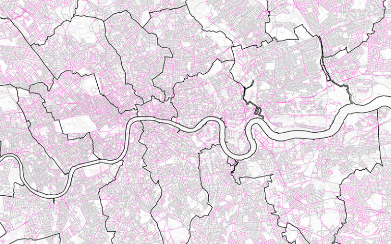
_Streets, a new research group involving Bartlett researchers, have analysed every street in Greater London and found that only 36% of pavements were at least three metres wide – the minimum requirement for members of the public to follow social distancing rules.
Of all London boroughs, the City of London has the highest percentage (51%) of streets that meet the minimum requirement of non-road space, while Hammersmith and Fulham, Wandsworth, Richmond upon Thames and Newham and Haringey all have the lowest percentages (between 26-28%).
“While some may opt to walk in the road, this is not possible for people with pushchairs or with mobility impairments. Our research shows that there is an urgent need to reallocate street space in London so everyone can use streets safely.
– Dr Ashley Dhanani, _Streets researcher and Research Associate at The Bartlett School of Architecture’s Space Syntax Laboratory
“Using new geo-computational techniques, we can study in detail the critical design parameters for the reorganisation of street space and inform planning decisions like pavement-widening, car-free zones and cycleways, which will effectively address the demands of social distancing.
– Nicolas Palominos, _Streets researcher and PhD Candidate at The Bartlett Centre for Advanced Spatial Analysis
Using their findings, _Streets have created a map that shows all the streets in London that total six metres across or more of non-road space.
_Streets research received funding from the Engineering and Physical Sciences Research Council (EPSRC) and The Bartlett Innovation Fund and was a collaboration between UCL researchers, Healthy Streets and Tranquil City. Researchers used data from the Ordnance Survey, collected in a working paper analysing street spaces in Greater London.
- Research team
- Ashley Dhanani, Research Associate at The Bartlett’s Space Syntax Laboratory and Acting Director of Innovation and Enterprise at The Bartlett School of Architecture.
- Nicolas Palominos, Urban Design Researcher and Spatial Data Analyst. PhD candidate at The Bartlett Centre for Advanced Spatial Analysis.
- Lucy Saunders, Public Health Specialist, Urbanist and Transport Planner. Creator of the Healthy Streets Approach.
- Grant Waters, Urban Soundscapes and Architectural Acoustics Specialist. Founding Director of Tranquil City.
More information
The Space Syntax Laboratory
The Bartlett School of Architecture’s Space Syntax Laboratory is an interdisciplinary research and teaching unit established in the 1970’s at The Bartlett School of Architecture, UCL. Space Syntax research studies the effects of spatial design on aspects of social, organisational and economic performance of buildings and urban areas and has led to a fundamental understanding of the relationship between spatial design and the use of space as well as longer term social outcomes.
The Centre for Advanced Spatial Analysis
The Centre for Advanced Spatial Analysis (CASA) is an interdisciplinary research institute within The Bartlett Faculty of the Built Environment, which explores the science of cities. The centre seeks to examine and offer solutions to the problems of resource efficiency and effective planning and governance shared by all cities.
Image: Street space for social distancing map, by _Streets.
Contains Ordnance Survey Data. Crown copyright and database right 2020.