 Close
Close

Planning space missions and measuring tropical trees
3 December 2018
Mat Disney promotes satellite missions at the Natural History Museum
UCL Geography's Professor Mat Disney and colleagues are involved with two new space missions to measure the state of the world's forests: NASA's GEDI and ESA BIOMASS. The team is providing ground measurements of forest structure and biomass to help calibrate and validate the satellite estimates. Mat's work in California, Gabon and Ghana has been funded as part of this by ESA (European Space Agency) and NASA.
- The NASA GEDI mission (Global Ecosystem Dynamics Investigator) was launched to the International Space Station on the 5th of December. GEDI is led by Professor Ralph Dubayah and the team at the University of Maryland and will use laser pulses to estimate the height, above-ground biomass (AGB) and structure of forests.
- The ESA BIOMASS mission by ESA and NASA is a RADAR instrument that will launch in 2021, aimed at measuring the biomass of tropical forests in a totally new way.
BIOMASS uses the so-called 'goldilocks' RADAR wavelength of 70 cm, which is long enough to penetrate tall, dense forests (and clouds), but short enough to provide fine detail on the size and shape of tropical trees. It will be unique in offering an all-weather, day and night picture of forests structure across the tropics. The BIOMASS science lead is Professor Shaun Quegan, from the University of Sheffield and the NERC National Centre for Earth Observation (NCEO).
On 30th November, Shaun and Mat were at the Natural History Museum Lates event
showcasing BIOMASS to the public. The event included NERC's Impact Award nominees, and Shaun was subsequently awarded the Economic Impact Award for bringing the BIOMASS mission to the UK.
The evening was spent chatting with the public, showing how BIOMASS will provide a new view of tropical forests using examples of satellite images, pieces of real trees, and some of Mat's 3D tree models.
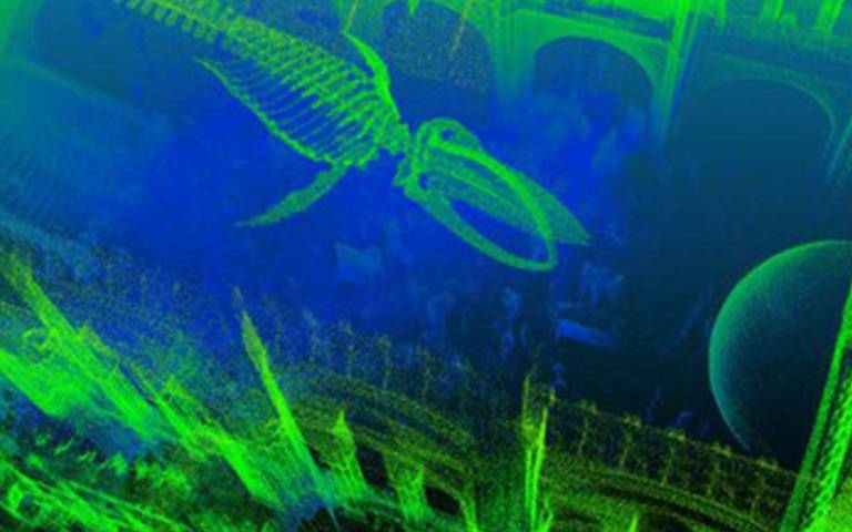
Mat’s 13-year-old son was also co-opted to collect lidar data in the NHM main hall during the event. The above image shows how well the lidar captures the 3D environment.
Mat's lidar team were also recently in Brazil, scanning large trees before harvesting them and weighing them piece by piece. Such measurements, collected as part of a (legal!) logging operation with Brazilian colleagues, are vital to assess the accuracy of the new satellite observations. Amazingly, the area where the team felled 3 trees could be seen from space using the ESA Sentinel 2 satellite, observing at 10 m resolution, before, during and after the UCL team's work.