PAST
Registered Office University College London, Institute of Archaeology, 31-34 Gordon Square, London WC1H 0PY


NUMBER 50 JULY 2005

Past 50
(1 Mb pdf file)

New Light on the Earliest Neolithic in the Dee Valley, Aberdeenshire
Long Meg: Rock Art Recording Using 3D Laserscanning
A First for the Society!
Society News
Introducing the Society’s New President
Society Correspondence
John Gwynne Evans
Graham Ritchie 1942-2005
A Ring Cairn and Beaker Burial at Gray Hill, Llanfairdiscoed, Monmouthshire
An Engraved Neolithic Plaque With Grooved Ware Associations
Niah Cave and the People of Sundaland


NEW LIGHT ON THE EARLIEST NEOLITHIC IN THE DEE VALLEY, ABERDEENSHIRE
A substantial timber building and pit-alignment just across the river from the well-known site at Balbridie indicates the significance of this area at the beginning of the Neolithic.

An early stage in the excavations of the timber structure
An early stage in the excavations of the timber structure: the straight end wall is visible in the centre, with the side walls curving into the baulk (photo credit NTS).

In May 2004, a two-week trial excavation in the Warren Field, on the Crathes Castle Estate, Aberdeenshire, was undertaken by Murray Archaeological Services on behalf of the National Trust for Scotland.

In the memorably dry summer of 1976, aerial photography revealed an extensive complex of crop-marks here, on terraces of the River Dee, including a pit alignment about 60m long and a rectangular structure with rounded ends. Although sitting directly across the river from the famous Early Neolithic timber building of similar scale at Balbridie, the Crathes structure was more often compared with a group of sub-rectangular crop-mark sites thought to be of Early Medieval date. Aiming to assess the degree of survival of the main known features and to attempt to characterize and date them, our evaluation project has transformed the picture: a good series of radiocarbon dates reveal that the building burned down at some point between 3650 and 3950 cal BC, and that the pit alignment appears to date to the same period. Apart from Balbridie, the only comparable structure excavated in Scotland is at Claish Farm, Stirlingshire.

Built on an east-west alignment, the building is about 9m by 20m, of which a quarter has been revealed so far. Ploughing of the shallow topsoil has removed floor levels, but the wall lines are indicated by post-pits cut into the subsoil: the side walls are distinctly bowed, with an almost straight end wall at the excavated (eastern) end. The building had been destroyed by fire, so the main posts were partially carbonized. This gives very precise details of the size and position of the oak structural timbers, which will allow some understanding of the building’s construction.

The timber structure after excavation.
The timber structure after excavation. The large, open pit within the structure is visible in the centre, with the straight end wall beyond (photo credit Murray Archaeological Services).
A possible entrance with outlying ‘porch’ posts was identified at the end of one long wall near the eastern ‘gable end’ of the structure. There is also some indication of an internal partition. At the moment there appear to be tantalising differences in plan between this and the other two excavated examples at Balbridie and Claish Farm, but no detailed comparisons are possible until the whole building can be excavated.

Two large pits at either end of the building were originally thought to have been for massive posts supporting a roof ridge-pole. Excavation of one of them suggests it was actually an open pit, possibly lined with branches of alder and hazel. When the building burnt down this pit became filled with a mixture of debris and occupation material from the interior, including large quantities of remarkably fine Early Neolithic pottery, flint and Arran pitchstone artefacts. The cereals recovered include barley, emmer and bread wheat – the latter extremely unusual in the Scottish Neolithic, but paralleled at Balbridie – and a grain of spelt, which until now has not been recognized in Scotland before the first millennium BC. Most exciting of all, fragments of carbonized birch wood survived, some with carved decoration, which appear to be pieces of turned bowls or other small objects. This is an incredibly humbling reminder of the range and quality of objects made of wood, leather, basketry and textile that rarely survive from Neolithic Scotland.

A carbonized fragment of birch wood
A carbonized fragment of birch wood with carved decoration (32 X18mm), excavated from the large pit within the timber structure (photo credit AOC Archaeology Group).
The pit alignment, lying some 150m west of the building, remains enigmatic. Topsoil was cleared from a 30m length, revealing five large pits and a number of smaller post-pits – the latter, too small to show up as cropmarks, suggesting that the monument is potentially of greater complexity than appears from aerial photographs. One of the large pits was excavated, revealing a charcoal-rich deposit over a thin build up of silt and gravel, probably representing an initial phase of erosion. Although flint flakes were recovered from the plough soil above the pit alignment, no artefacts or environmental evidence were found within the excavated feature.

That charcoal from the fill has produced a radiocarbon date range analogous to that of the timber structure is fantastically satisfying, confirming the Warren Field project to be an enormously important opportunity to examine two rare monument types within their wider landscape context, rather than as isolated phenomena, and to begin to tease out the details of Early Neolithic inhabitation of the valley. The very close proximity of Balbridie, only a kilometre away on the opposite bank of the Dee, highlights the importance and particularity of the place in any assessment of the nature of changing lifeways in eastern Scotland some 5,500-6,000 years ago.

Given this unparalleled opportunity to explore the specific expression of new frameworks for living as they developed in northeastern Scotland during this period, we are undertaking a further season of excavation in June 2005. We will be examining the sites in more detail and exploring other elements of the wider crop-mark complex at Crathes, which may shed light on the relationship between massive timber buildings and the more ephemeral settlement features commonly associated with the Early Neolithic in Scotland.

Shannon Fraser, The National Trust for Scotland
Hilary Murray, Murray Archaeological Services

Acknowledgements
The Warren Field Project (Phase I) was funded by the National Trust for Scotland, Historic Scotland, Aberdeenshire Council and the Prehistoric Society.


LONG MEG: ROCK ART RECORDING USING 3D LASERSCANNING

Figure 1
Figure 1: Long Meg 3D laser scanner data coloured according to relative elevation.
For more than a century, the documentation of most British prehistoric rock art has been undertaken by a small number of antiquarians and avocational archaeologists including James Simpson (1865), Ronald Morris (1981) and, more recently, Stan Beckensall (1999) and the Ilkley Archaeology Group (Boughey & Vickerman 2003). Techniques used to record the carvings have varied from tracing, free-hand drawing, to photography and wax rubbing, the latter being that most commonly used during the last three decades. Although these approaches provide adequate information to identify each carving and give an impression of the designs, they cannot reproduce the degree of detail and accuracy required by today’s researchers and conservationists. The traditional techniques are inherently subjective; they rely heavily on the skill and experience of the recorder as well as on prevailing lighting conditions. The process of transferring a 3D object onto a 2D piece of paper also has obvious limitations. Even the most experienced protagonists acknowledge that repeated visits to the same site may produce different results. 3D laser scanning has the potential to revolutionise rock art recording. It produces highly objective and accurate 3D models providing reliable, detailed information for both researchers and conservationists. Laser recordings may even identify previously unknown carvings, as demonstrated by recent discoveries at Stonehenge (Goskar et al.2003).

Figure 2
Figure 2: Perspective view of Long Meg laser scanner data using absolute elevation rendering relative to the average rock face plane. The dark region has a higher elevation than the top and bottom region of the face.
The project “Breaking through rock art recording: three dimensional laser scanning of megalithic rock art”, sponsored by the Arts and Humanities Research Board (now the Arts and Humanities Research Council) under the Innovation Awards scheme, aimed to explore the potential of this novel technique. The one year project was undertaken by the University of Durham, led by Margarita 
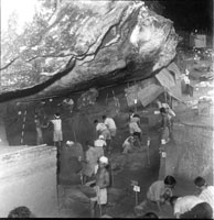
Díaz-Andreu, and began in March 2004. The main sites analysed were the stone circle at Castlerigg and the standing stone of Long Meg in Cumbria, in addition to the Copt Howe panel, also in Cumbria, and the Horseshoe Rock site in Northumberland where an investigation on 3D representations had been previously undertaken (Simpson et al. 2004; Trinks et al. forthcoming). This article focuses on the results obtained at Long Meg (NY56933716, CCSMR6154, NMR 23663), comparing two different methods to visualise the rock art data, one developed by Hobbs and Trinks using freely available software, and the other one undertaken by Nick Rosser employing software especially developed for archaeology by Archaeoptics Ltd but no longer commercially available unless the Archaeoptics laser scanning service is also purchased. Two previous recordings 
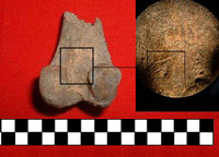
existed of the carvings on the western face of the pillar: an early recording first published in 1867 by Simpson in the form of a lithograph by A. Ritchie (Simpson 1867, plate VII), and a wax rubbing produced by Beckensall (2002, fig. 70).

The recording of Long Meg with 3D laser scanning was undertaken in several phases. The first phase included the laser scanning and pre-processing of data. This was undertaken by a team led by Dr Alan Chalmers, University of Bristol. The data set acquired with a Minolta 910 laser scanner consisted of roughly 45 million points (26 million of which came from the north-easterly facing panel where the carvings are located), with overlaps in excess of 25% between the coverage of each scan. The recording took approximately twelve hours and involved the creation of 102 ‘patches’ of rock surface which were then ‘stitched’ together electronically to create the complete 3D model.

Figure 3
Figure 3: Left – front face of Long Meg, showing the result of the high-pass convolution filter. The grey scales indicate the degree of surface indentation, with black areas showing the deepest cuts. Right – shows the result of the threshold filter applied to the processed surface image. The threshold removes noise from the surface topography and identifies significant features.
The second phase was the development of new processing and 3D visualisation methods to visualize the rock art contained in the data. This was undertaken by two different approaches. A new method was developed by Immo Trinks and Richard Hobbs of the Department of Earth Sciences at the University of Durham using the Visualization Toolkit (VTK) and Generic Mapping Tools (GMT) software. The original data was resampled to 645,432 points since the overlapping scan areas contained a large amount of redundant information. The carved front face of Long Meg was transformed into horizontal orientation and the data points were gridded using a 2D triangulation algorithm (Wessel & Smith 1991). Subsequently a spatial high pass frequency filter was applied to the 3D surface data, removing the long-wavelength surface structure of the rock (Trinks et al. forthcoming). Thus, the relative local elevation could be rendered using colour intensity values (Fig. 1). Figure 2 shows that elevation rendering without the removal of the low-frequency content, which represents the large-scale topography of the rock, would fail to highlight the rock carvings. It is possible to map the relative elevation colour values onto a digital 3D rock model, in order to visualize small scale variations in the rock surface. This option is particularly interesting should the rock have strong 3D structure. Due to the relatively plane structure of the front face of Long Meg (Fig. 2) this step was not considered necessary.

A second method of visualising the data was undertaken by Nick Rosser, Geography Department, University of Durham. Data was processed using firstly Demon3D (Archaeoptics Ltd) and then ENVI RT 4.0(RSI). The initial stage of the processing involved trimming the point cloud of the data beyond the area of interest to reduce data processing time. The point cloud was then triangulated using a 2.5 dimension view dependant triangulation algorithm. This was conducted from a view angle which was normal to the dominant plane of the rock face. The triangulated surface was edited, with long triangles removed to reduce interpolative errors on the surface. The meshed surface was then rendered and light from 3 directions applied to enhance the differentiation of surface texture and features for visualisation. The second stage of the data processing involved the detection of surface features. Given the curvature of the rock face a simple contour or height rendering does not represent the surface detail well.
Figure 4
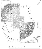
Figure 4: Top – diagram showing the location of profiles 1, 2 and 3 on the carved face of Long Meg. Bottom – graphs showing the three profiles extracted: 1) well defined human made carving; 2) natural rock fracture; and 3) degraded human made carving.
To overcome this, remote sensing image analysis techniques were applied, using ENVIRT 4.0 (RSI). The edited point cloud data from Demon3D was imported into ENVI, and gridded at 0.0005 m resolution, which derived a raster of the rock surface topography. A high pass convolution filter with kernel width 29 mm was then applied to the image to remove long wavelength surface curvature, but retain surface detail (Fig. 3 left). This kernel size was found to remove the general rock surface topography but maintain surface detail well. A triangulation threshold algorithm was then applied to the resulting image. The level of the threshold revealed different levels of detail on the image and was tailored to filter out noise (Fig.3 right). Three profiles cut vertically through the surface were extracted using Demon3D (Fig. 4). Profile1 illustrates profiles across a human made carving, where the carved grooves have a rounded cross sectional form but are distinct indentations on the profile. Profile 2 shows a natural fracture, which is deeper, weathered, and non-symmetrical. Profile 3 shows a weathered carved surface, and here it is noticeable that the surface definition is less clear than that seen in Profiles 1 and 2, with less differentiation between the carved grooves and surrounding surface.

The results of the analysis of 3D laser scanning data demonstrate the power of the technique to capture the features accurately and objectively. Both methods have provided very similar results. In order to describe them we have superimposed the image with a grid (Fig. 3). Because of the limitation in the number of words, a detailed description is not possible here. In brief, our recording has identified three certain cup and ring motifs and one spiral and another five possible cup and ring motifs. The first are located, from top to bottom and left to right, in 45C, 67C and 9B and the spiral in 78CD. The possible cup and ring motifs are placed in6CD, 78BC, D7, 89C, 910B. There may be some evidence of a circular motif in 34D. There seems to be some evidence of the loops recorded by Beckensall in 6C, but there are not clear. The analysis of profiles taken across the surface shows distinct differences between natural and human made surface features. Additionally, there are considerable differences in the degree of angularity and rounding across the ring motifs identified, which have potential to act as a measure of the relative age of the carvings. In comparison with previous recordings, laser scanning really represents a quantum leap in rock art recording. The technique offers significant advantages over previous methods of recording, namely: objectivity in recording is hugely improved in relation to traditional techniques such as rubbing; results are reliable and reproducible; the level of precision achieved is much greater than that obtained with any other method currently available, including photogrammetry; and the recording process is non-invasive and so not detrimental to fragile rock surfaces.

M. Díaz-Andreu, project leader, Department of Archaeology. University of Durham.
R. Hobbs, Department of Earth Sciences, University of Durham.
N. Rosser, Geography Department, University of Durham.
K. Sharpe, research assistant, Department of Archaeology. University of Durham.
I. Trinks, Department of Earth Sciences, University of Durham

Acknowledgments
We are grateful to the owner of the site for permission for access.

References
Beckensall, S. 1999. British Prehistoric Rock Art. Stroud: Tempus.
Beckensall, S. 2002. Prehistoric Rock Art in Cumbria: landscapes and monuments. Stroud: Tempus.
Boughey, K. & Vickerman, E. 2003. Prehistoric Rock Art of the West Riding: cup-and-ring-marked rocks of the valleys of the Aire, Wharfe, Washburn and Nidd. Leeds: West Yorkshire Archaeological Services.
Goskar, T. A., Carty, A., Cripps, P., Brayne, C. & Vickers, D.2003. The Stonehenge Laser Show. British Archaeology 73, 9-15.
Morris, R. 1981. The Prehistoric Rock Art of Southern Scotland, except Argyll. Oxford: British Archaeological Reports, British Series 86.
Simpson, A., Clogg, P., Díaz-Andreu, M. & Larkman, B. 2004. Towards three-dimensional non-invasive recording of incised rock art. Antiquity 78, 692-8.
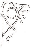
Simpson, J. Y. 1865. On ancient sculpturings of cups and concentric rings. Proceedings of the Society of Antiquaries of Scotland 6, 1-140.
Simpson, J. Y. 1867. Archaic Sculpturings of Cups, Circles & c. upon Stones and Rocks in Scotland, England & Other Countries. Edinburgh: Edmonston & Douglas.
Trinks, I., Díaz-Andreu, M., Hobbs, R. & Sharpe, K. Forthcoming. Recording rock art using 3D laser scanner data. (Submitted).
Wessel, P. & Smith, W.H.F. 1991. Free software helps map and display data. Eos Transactions of the American Geophysical Union 72 (441), 445-446.


A FIRST FOR THE SOCIETY!

This year saw the first Prehistoric Society student study tour make its way to the Lake District. From archaeology departments around the country, undergraduate and graduate students left their books and essays to see some fantastic archaeology in one of the most scenic and diverse landscapes in Britain.

The Lake District is a place that many people have come to see as a holiday destination, to walk the fells, sail, draw, or merely sightsee. It had never occurred to me that the rugged beauty of the Lakes was interwoven and tied up with such a plethora of archaeology and history. It is easy to think that the landscape has always been as the Romantics saw it, immortalised in the literature we know so well, and that it will remain so. Instead, as Mark Edmonds, Bob Bewley and Jacqui Mulville showed us around the wide range of sites in the area, a picture emerged of how the natural and human elements of this landscape had combined and changed over time to create the patterns of settlement and land use which we see today. Not only this, but it began to show a whole new perspective on archaeological sites within their setting, one which can be hard to achieve through just reading about them.

It was on a fine afternoon at the beginning of April that we all came together at Windermere station, and made our way to the National Trust bunkhouse at Hawkshead. It was a great time of year to be in the Lakes, at the height of spring, as the vegetation recovered from the winter gales, and lambs filled the fields. The bunkhouse itself was set amongst the trees on a hillside, and offered a cosy place to stay. Being both comfortable and spacious, it allowed everyone to gather in the evenings and have a good chat and a drink or two!

On Saturday, we piled into the mini-buses, and set off for Langdale, to climb up to the sites of Neolithic axe production. Walking along the valley, Mark and Bob explained the history of land division, pointing out the areas of cultivation and stone walls. Even the persistent rain did not spoil the beauty of the valley, a patchwork of greens and browns, with jagged teeth of rock rising high to each side. After a tea break in a sheep pen towards the top of the valley, we turned to start climbing up the steep path which zig-zagged its way alongside a gushing stream. Rain turned to snow as we neared the top, and half the group decided to return back down to the warmth of the pub!


The rest of us continued along the path, surrounded by a landscape fast disappearing under a layer of snow. The quarries and worked stone could be identified in many locations once we knew where to look for them, and where the snow did not obscure them from view. Seeing the evidence of Neolithic axe manufacture within an active setting made a huge difference in my perception of objects which are so often encountered in static museum cases. It really gave a sense of why people might have gathered here to work the stone, and the relationships which may have evolved through the manipulation of the landscape. We then descended back into the valley accompanied by amazing views, and made our way straight to the pub, to enjoy a good pint and warm our feet again! On our way back to Hawkshead, we stopped to look at some recently discovered rock art on a large boulder: an interesting aspect to think about in relation to the quarries and worked stone of Langdale.

The next day was lit by glorious spring sunshine as we headed over towards Ullswater. We began by looking at a curious enclosure of uncertain date, containing suspected Roman signal stations and sheep pens. It occupied a great location, in sight of Brotherswater, at the meeting point of three valley spurs. Next, we went to explore the archaeology along the lakeside at Ullswater, taking in some Iron Age settlements, as well as numerous enclosures and cairnfields. After a good lunch at Pooley Bridge, we drove up towards Penrith. Here we looked at Mayburgh henge, a striking site due to its sheer size and domination in the landscape. Its bank was made up with river cobbles, and built so as to shut out most of the horizon once you were inside. A standing stone stood vigil in the centre, providing a focus for the eye, and acting to lead the body through the monument. From there, we walked a short way to another henge visible from Mayburgh, King Arthur’s Round Table, where we lay in the sunshine for a while, taking it all in. Long Meg and her daughters was the next site to be explored. Long Meg, the largest stone, stood at the head of the circle, casting a shadow as Mark explained what lay before us.

After a fun last night at the bunkhouse, we cleared out, and set off to see the last site of the visit: Castlerigg stone circle. Placed at the meeting point of many valleys, and overlooked by Bronze Age cairns, this circle has real character, at once both natural and unusual in the landscape. We explored the stones from every angle, before returning to the bus, and beginning our goodbyes.

The trip was a fantastic way of exploring a beautiful area, looking at the archaeology, but also appreciating the landscape as a whole. For £55, we were able to stay in a comfortable bunkhouse, and see a huge range of sites. The diversity of people allowed a broadness of interests and it was great getting to know everyone. It was also a brilliant opportunity to be shown around by such enthusiastic, and interesting people: Mark, Bob and Jacqui did a really good job, which everybody really appreciated. I know that if the trip was running again, many people would think about returning. When so much time is spent by students of archaeology reading and writing about sites, it is refreshing to be able to get out into the landscape and really take in every aspect of a site, and have the time and stimulation to think about it properly. This trip allowed us to fully experience the sites, whilst communicating a wide variety of knowledge. Great fun was had by all, and I would definitely recommend it!

Rose Ferraby,
Dept. of Archaeology, University of Cambridge

SOCIETY NEWS

Professor Zilhão with the newly-elected President of the Society, Professor Aldhouse-Green

Professor Zilhão with the newly-elected President of the Society, Professor Aldhouse-Green

Members who attended this year’s AGM will be aware that the notice of the meeting in the last edition of PAST included a rather embarassing error. Professor Graeme Barker was listed as nominated by Council to stand as the next President. Of course, Professor Barker is our outgoing President, while the correct nominee should have been Professor Miranda Aldhouse-Green. Apologies from the Editor!

The AGM was held on 1 June and saw the election of Professor Aldhouse-Green as the Society’s new President. At the end of a productive term of office, our outgoing President, Professor Barker, was duly thanked for his contribution. Jonathan Last, Geoffrey Halliwell and Robert Hosfield were elected onto Council. Our able Honorary Meetings Secretary, Jacqui Mulville, has unfortunately had to stand down for personal reasons, so Vice-President Dave McOmish, who has served as Meetings Secretary in previous years, took up this role once again.

Dr Roger Jacobi is presented with the Bagueley Award by Vice-President, Dr Frances Healy.
Following the AGM, the 14th Europa Prize was awarded to Professor João Zilhão of the University of Lisbon. In a stimulating and often wittty presentation, Professor Zilhão examined the processes by which Modern Humans came to replace Neanderthals in Europe some 42,000 years ago. Employing archaeological, biological and genetic evidence including the results of his excavations at Oase in Romania, he argued for significant interaction between the two groups including exchange and interbreeding. As always, the lecture was rounded off by a wine reception and plenty of informal discussion.

The Bagueley Award for 2004 was presented to Dr Roger Jacobi for his paper in PPS70, ‘The Late Upper Palaeolithic lithic collections from Gough’s Cave, Cheddar, Somerset, and human use of the cave’.

INTRODUCING THE SOCIETY’S NEW PRESIDENT

President of the Society, Professor Aldhouse-Green

President of the Society, Professor Aldhouse-Green

The new President of the Prehistoric Society, as from June 1st, is Miranda Aldhouse-Green. Miranda is Professor of Archaeology at University of Wales, Newport, and a former Vice-President of the Society. Her research interests lie in later British and European prehistory, especially in the material culture of ritual and religion during the Iron Age, in cultural interaction within the Iron Age/Roman transition in western Europe, and the study of figural imagery.

Born and educated in London, Miranda graduated from Cardiff University with a BA in Archaeology. This was followed by further studies at Oxford where she was awarded an MLitt and at the Open University where she gained a PhD. Positions at Worthing and Peterborough Museums were followed by a Leverhulme Research Fellowship at the Ashmolean Museum in Oxford. Subsequently, Miranda worked as an Administrator at the Open University in Wales and a temporary lecturer in archaeology at Cardiff University before moving to join University of Wales, Newport.

Among her recent publications are An Archaeology of Images (Routledge 2004) and (with Stephen Aldhouse-Green) The Quest for the Shaman: shape-shifters, sorcerers and spirit-healers of ancient Europe (Thames& Hudson 2005). Miranda lectures regularly overseas: most recently, she delivered three lectures at the Smithsonian Institution; the 26th Kroon Lecture at the University of Amsterdam; and the Joan Vastokas Distinguished Lecture in Art and Archaeology at Trent University, Ontario.

Apart from archaeology, Miranda’s interests include Burmese cats (of which she has three), early and choral music (she sings with the Cardiff Bach Choir), foreign travel, swimming and wine. Miranda is married to fellow prehistorian (albeit a much earlier one!), Stephen, and they have one daughter, Elisabeth. She greatly looks forward to her term of office as President of the Society and to meeting many of its members at study tours and other events. Hwyl!

Society Correspondence
 

Please note that our Society Administrator, Tessa Machling, will be on maternity leave during November and December 2005. During this time, she will continue to deal with Society correspondence. However, we would be grateful for your understanding as responses may take a little longer than usual while Tessa is juggling baby and work.

JOHN GWYNNE EVANS
 

It is with tremendous sorrow that as PAST went to press we heard that Professor John G. Evans died suddenly on the 13th of June 2005.

Professor John G. Evans
John was widely known in the British archaeological community and made a great impact upon archaeologists and archaeology alike in his own inimitable style and maverick way. He was a friend and mentor to many of us, and all will remember him with great affection. He made an immense contribution to palaeoenvironmental research, focussing particularly on the archaeology of the chalk downland of southern England, and some of our most important prehistoric landscapes around Avebury, Stonehenge and Maiden Castle, to name but a few.

After completing his Ph.D. thesis on the use of land mollusca as indicators of the environment of ancient man at the Institute of Archaeology in London, John returned to Wales where for the next thirty years he was a lecturer and latterly professor in the Department of Archaeology in Cardiff. At least three generations of archaeologists were brought up on John’s seminal works: The Environment of Early Man in the British Isles(1975), Introduction to Environmental Archaeology (1978), and more recently Environmental Archaeology: Principles and Methods(1999; with Terry O’Connor). His Land Snails in Archaeology (1972) established the study of land snails as a standard analytical method in British field archaeology. More recently, his thinking and writing had become more adventurous in Environmental Archaeology and the Social Order (2003) in which he was willing us as environmental archaeologists to think of the meanings of our work in terms of people inhabiting landscapes.

John was involved in editing the Proceedings of the Prehistoric Society from 1975 (vol 51) to 1994 (vol 60), producing 20 volumes containing many papers and site reports upon which much of our current archaeological foundation is based. He was elected on 2nd May 1974 to the Society of Antiquaries, London, resigning twenty years later.

He will be remembered for his individual style, including ejecting potted plants through opened pub windows because they were irritating to the eye, but also for his guidance of and kindness towards the next generations of archaeologists. His enthusiasm was infectious and anyone showing an interest in his work or challenging his ideas was in for a great experience of discussion, debate and banter.

John was an influential figure both as an environmental archaeologist and prehistorian, and an old-fashioned field naturalist to whom nothing was less than interesting, and many things were a source of fascination and wonder. Working with John was seldom predictable, often exhausting, but always stimulating and mind-broadening. His interest in, and concern for, his friends, their families and their pets was warm and genuine, and many of us will miss a good friend and colleague. Salute John.

Mike Allen, Charly French, Terry O’Connor


GRAHAM RITCHIE 1942-2005


The society was deeply saddened to learn of the sudden death on 27 April 2005 of Dr Graham Ritchie. Graham’s distinguished career in Scottish prehistory earned him a reputation as an outstanding field archaeologist, writer and lecturer. He was introduced to archaeology at the University of Edinburgh by Charles Thomas and Stuart Piggott, and graduated with a PhD on Celtic armour and weaponry in 1968. He joined the Royal Commission on the Ancient and Historical Monuments of Scotland in 1965, and soon earned a reputation amongst his colleagues for his dedicated and meticulous survey and excavation work which resulted in the publication of significant archaeological resources, notably the five volumes of the inventory for Argyll.

Graham wrote for both an academic and a public audience and his many writings are widely cited. He was a regular contributor to scholarly journals such as the Proceedings of the Society of Antiquaries of Scotland. He edited the highly-respected synthesis The Archaeology of Argyll (1997) and produced many works on specialist topics. He also assisted Audrey Henshall in revising her magisterial Chambered Tombs corpus, contributing to the volumes on Sutherland and the central Highlands. He had the gift of bringing archaeology to a wider audience, both in the field and the lecture room, and produced several accomplished guidebooks, notably the Oxford Archaeological Guide to Scotland (1998) (with his wife Anna).

Graham’s career at the Commission culminated in1995 with his appointment as Head of Archaeology. He was also deputy curator of the National Monuments Record of Scotland, and in this capacity was involved in the development of innovative ways of ensuring public access to archaeological information and archives. He had a life-long interest in the use of early illustrations for the better understanding of sites and monuments and used this to good effect in the excavations he directed at Balbirnie in Fife and the Stones of Stenness in Orkney. His prompt publication of these projects, and of his other fieldwork such as short cist excavations, are models of good practice. He was a faithful servant of the Society of Antiquaries of Scotland and served as its President from 1999 to 2002. A warm, generous and astute individual who acted as a mentor to many younger archaeologists, he will be sadly missed by all those who knew him both in Scotland and further afield.


A RING CAIRN AND BEAKER BURIAL AT GRAY HILL, LLANFAIRDISCOED, MONMOUTHSHIRE
 

Plan of the ring cairn
Plan of the ring cairn, following removal of tumble, clearance cairns and the surface of horizontal slabs 338 (drawn by A. Leaver).

In Past 44, we reported on the first year of the Gray Hill Project, examining a multi-period upland landscape in south-east Wales. The project has been investigating a scarp-edge D-shaped enclosure; co-axial, double orthostat field boundaries; and clearance cairns. Although samples taken for C-14 and OSL dating have not yet been processed, all of these features are likely to be prehistoric in date. Earlier survey work had identified a probable ring cairn on the southern slope of the hill. Some 60% of this monument has now been investigated by the project – total excavation was not felt to be appropriate for logistical and ethical reasons. Excavation demonstrated that the cairn was relatively undisturbed, and approximately 13m in diameter, but slightly ovoid in plan.

The ‘ring’ itself was roughly 12m in diameter and around 2m wide, with a series of large and regularly spaced sandstone slabs set at steep angles against the inner face of the bank. Between the larger orthostats were occasional smaller blocks. These facing slabs were all set within a narrow ring slot, and in order to get the tops of the slabs roughly level, some had levelling and packing stones set below and around them. The ring bank was an intricate construction, with possible radial divisions formed by further tabular blocks. In the south-eastern quadrant, individual ‘cells’ were filled with different kinds of stones – some freshly quarried and fractured, others weathered and worn. Two possible original entrances were identified to the north-west and south-east, although these were later blocked. Beneath the ring cairn bank, several stakeholes were also excavated, but it is not clear if the ring bank was preceded by an earlier, timber stake ring structure.

Photograph of the seven barbed-and-tanged arrowheads
Photograph of the seven barbed-and-tanged arrowheads recovered from the lowermost deposit within grave pit 344 (photograph by A.Leaver).
The interior of the embanked space was filled with two or three courses of angular sandstone slabs, laid horizontally to form a very rough platform. In the centre of the ring a small mound of smaller, more fractured stones overlay the horizontal stones, but had sunk into a cut feature below. This was a large pit [344], steep-sided and lined with large sandstone blocks. Underneath an upper fill of angular sandstone fragments was a smaller stone setting about 1m across, associated with charcoal and burnt stone, and from this came a segmented, blue-grey faience bead. This is the first such find recorded from South Wales, and one of only a few from Wales as a whole. Analysis of the bead by Dr. Alison Sheridan of the National Museum of Scotland and Dr. Mary Davis of the National Museum of Wales could not determine its mineralogical source, but it is similar in form to examples from southern England.

At the very end of the 2003 season, the presence of a primary inhumation burial within the pit was hinted at by two barbed-and-tanged flint arrowheads found near the base of the pit. The pit was fully excavated in 2004, and five further barbed-and-tanged arrowheads were discovered. The two found in 2003, and two of the 2004 arrowheads, were clearly ‘pairs’, each pair made in a similar style and on almost identical flint, but perhaps by two different flintknappers. Of the three remaining arrowheads, two are more unusual forms made on flakes. Rim and body sherds of Beaker pottery from at least two different vessels, and possible base sherds of a Collared Urn, were also recovered. Not more than 5% of any pot was represented, though, and they were probably removed in antiquity, before the secondary deposits were added. An unidentified small metal object was also found. The sherds and arrowheads do seem to have been scattered by the later disturbance. No traces of human bone or even soil stains were found, but a stone-free area in the centre of the pit was probably where an inhumation burial was located. This is the first Beaker burial known from south-east Wales.

Plan of central pit cut 344
Plan of central pit cut 344, showing the timber mortuary structure and the horizontal slab with cup and ring decoration(drawn by A. Leaver).
The deposit containing the arrowheads and pottery sherds lay within a rectangular area defined by narrow slots and postholes for vertical and horizontal timbers. These formed a timber mortuary structure, set within the much larger grave pit. It is not clear if there was a fourth side to the structure – the north-west side of the grave seemed to have been disturbed, perhaps during the insertion of the later stone setting. On the south-eastern edge of the grave, a large horizontal sandstone slab had two possible carvings on its upper surface, including a cup and ring mark. This stone was close to the south-eastern entrance through the ring bank, and may have been a platform where people could stand and look down into the open grave before it was backfilled. Further construction episodes followed the infilling of the central grave, including a 1-2m wideband of additional sandstone blocks added on the southern side. Underneath this were at least four circular postholes, and the southern side of the ring cairn was probably marked by upright timber posts 2-3 metres high, at least in an early phase. The cairn was also respected by later co-axial field boundaries, and by several smaller ‘satellite’ cairns. Two of these cairns were excavated in 2002 and 2003, and although they did not produce any finds, there was a respect and formality evident in their construction.

The Beaker pottery and the barbed-and-tanged arrowheads suggest the primary deposit in the central pit took place around 2300-1800 BC, and the secondary deposit with faience bead somewhere between 1800-1600 BC. Activity at the site clearly did not end with the creation of the central mound over the burial pit. Further stone was progressively added to the cairn, particularly on its southern side, eventually leaving the monument as a large platform or mound. The creation of smaller clearance cairns followed on from this, perhaps without any hiatus. The structure was transformed from an open, bank-defined monument in what was possibly a largely open landscape, to an essentially ‘closed’ construction in an increasingly enclosed setting. The cairn continued to bean important focus even after formal constructional activity had ceased, and was woven again and again into the lives and stories of those who followed. It was not a ‘monument’, constructed as a planned entity, nor can its constructional development be neatly sub-divided into self-contained phases. Instead, here we have many different materialities, a sense of many different connections being made, and perhaps even different groups of people making them. Attempting to fit this construction into some artificial typology would be to ignore the organic character of its coming into being.

Adrian Chadwick, University of Wales Newport, and Joshua Pollard, University of Bristol

Acknowledgements
We would like to thank Mr and Mrs Stephens and Mr and Mrs Micklethwait for their continued support and co-operation, our colleague Dr Mike Hamilton, Graham Makepeace for his knowledge and enthusiasm, and all of the students and volunteers who took part. Anne Leaver provided vital logistical assistance and produced the illustrations. Dr Helen Lewis of the University of Oxford undertook soil micromorphology and pollen sampling, and Dr Phillip Toms of the University of Gloucestershire carried out sampling for Optically Stimulated Luminescence dating. Dr Mary Davis of the National Museum of Wales and Dr. Alison Sheridan of the National Museum of Scotland conserved and studied the faience bead. The 2003 season at Gray Hill was funded by the Board of Celtic Studies, the British Academy and the SCARAB Research Centre, and UWN funded the 2004 season.


AN ENGRAVED NEOLITHIC PLAQUE WITH GROOVED WARE ASSOCIATIONS

Plan of the pit
Plan of the pit from which the plaque was recovered showing density of lithic and ceramic finds and the findspot of the plaque itself (black dot)

Recent excavations at Rothley, Leicestershire, have revealed a Late Neolithic pit complex associated with a rich assemblage of Grooved Ware. The site is near the bottom of a north-facing slope to the west of the river Soar. The most prolific feature in terms of finds was a large, flat-based pit with an irregular trefoil-shaped plan. It is suggested that this was a sunken-featured building with the ‘stalk’ as the threshold. The infill produced several thousand decorated sherds, lithics and a remarkable engraved stone plaque displaying a rare example of figurative art.

The plaque and associated finds
The plaque is c. 200 x135 mm in size and is made of a finely grained sandstone, probably derived from a skerry bed in the local Mercia Mudstone deposits. It is incomplete having been broken in antiquity, but enough survives to suggest that the original design would have been symmetrical and may be described as a stylised face set within a rectangular frame. The face motif was executed with near-parallel lines while the frame was of a slightly broader and deeper line. The eyes were formed by two double concentric rings with curving eyebrows that link to the frame. The nose was formed by a slightly squashed lozenge with a linking chevron that formed the cheek. There are slight traces of a mouth, probably formed by another lozenge.


The lithic assemblage from the feature was mostly debitage but included some 25 flint scrapers, many in fine condition and abandoned long before being exhausted. Two Group XX (Charnwood) axes had been ‘undressed’ whereby the original polished surface has been systematically removed by flaking. The resulting cores were capable of producing further flakes but they were also abandoned before being exhausted. A preliminary scan of the ceramics gives the impression that it is all Grooved Ware of Woodlands style, with many highly decorated pieces.

Other deposits
A small pit c. 5m east of the latter feature produced another placed deposit comprising calcined flint and animal bone, Grooved Ware from a single vessel, a large stone rubber and a ceramic ball (of golf ball size). The large rubber was fabricated from a slab of skerry sandstone and showed signs of wear at one extreme. The lithics included a flint axe that had been completely calcined by intense heat to the point of exploding. Another small pit nearby contained a (now) sterile fill that had been sealed with a large sandstone slab.

Discussion

The Rothley site adds to an increasing number of Grooved Ware sites found in recent years in the East Midlands. The interpretation of the large feature as a sunken-featured building finds some local parallels in the structures recorded at Aleck Low, Derbyshire, while two recent examples of large sub-rectangular Grooved Ware pits at Eye Kettleby and Braunstone, Leicestershire, can be highlighted as possibly similar structures. While much of the material culture and site structure canbe compared to sites from regions with higher GroovedWare profiles, such as Wessex and Yorkshire, there areother elements that appear unique such as the rubber,ceramic ball and the plaque with the stylised face.

While there are examples of other engraved plaques with Grooved Ware associations, for example at Amesbury in Wiltshire, there are none with figurative art. Perhaps the closest parallel in terms of mobiliary art is the Folkton drums with their eye and eyebrow motifs. The opposed bar chevrons and lozenge used on the ‘face panels’ of the drums also find a broad parallel in the Rothley plaque. Indeed, these geometric elements do appear to be a leitmotif of the Grooved Ware style.

The acts of deposition at Rothley were certainly structured, and included elements of intentional destruction with the breakage of the plaque, the burning of flint artefacts and animal bone, the flaking of the axes and, probably, the breakage of the pottery. Larsson has described the intentional destruction of flint axes and other artefacts by fire as a Middle Neolithic phenomenon in Sweden. He suggests that the colour change to white may have been appropriate to certain rites of passage. At Rothley, the final act of deposition may be seen as such a rite, perhaps as an act of closure to the site habitation.

Lynden Cooper and Leon Hunt


NIAH CAVE AND THE PEOPLE OF SUNDALAND

Excavation in the ‘habitation zone'
Excavation in the ‘habitation zone’, 1958, Great West Mouth, viewlooking southwest.

45,000 years ago, a small group of modern human hunter-gatherers were quietly moving through the leafy green understorey of a large unbroken tract of tall dipterocarp rainforest. If they had come from the nearby river, they would have swiftly passed into a sea of green of mosses, ferns, climbing vines of thorny rattan, clinging ephipytes, and a seemingly endless cascade of leaves of every size and variety. As they passed along the forest floor, stepping around the buttress roots of huge towering hardwoods, their eyes would have been scanning downwards for tracks of hidden game and into the undergrowth for the right shaped leaf of an edible or medicinal plant, and upwards for movement and colour, as the arboreal animals they often depended upon moved about the tree tops feasting on fruit. Their well-practiced ears would have been listening for the telltale sounds of forest floor disturbances, giving away the location of shy, but larger game such as pig, deer, and wild cattle. Amongst the humans perhaps their only sounds were quiet chatter about their new environment and the gentle slap of hunting and foraging equipment such as spears, knives and digging sticks, made from wood, bamboo and rattan. Who were these people and what were they doing here in the Pleistocene rain forests of Sundaland?

The research aims of the Niah Cave Project are entirely scientific, but at their heart, the real challenge to all of us who have worked there is to understand the people who used the cave in millennia past. From 2000 to 2003, a multi-disciplinary team of archaeologists and environmental scientists was organised through the University of Leicester led by Professor Graeme Barker and the staff of the Sarawak Museum, Malaysia, to provide a definitive interpretation of the site’s archaeology.

The cave was first excavated by the brilliant but cantankerous Tom Harrisson (1911-1976), a self-trained archaeologist, curator and ethnologist at the Sarawak Museum from 1947 to 1967, who realised the enormous potential of this site and began excavation in 1954. Major excavation with a huge team of trained labourers continued in 1957, with regular field seasons up to 1967. A find that attracted considerable attention in 1958 was the discovery of a human skull and some associated post-cranial remains from the front of the West Mouth of the cave, in a layer radiocarbon dated to c. 40,000 years BP. Our work has since verified the antiquity of this deposit using ABOX AMS 14C to be about 43-44,000 BP. Flaked stone and other evidence of human activity occur in these layers. Detailed evidence of human hunting and foraging behaviour continues in units securely dated from at least 33,790±330 (OxA-11302), up to the last millennia overlapping with an extensive Neolithic cemetery in the cave, largely excavated by Tom’s wife, Barbara Harrisson.

Modified bone point from the 40-45 kya deposits, West Mouth, Niah Cave
Modified bone point from the 40-45 kya deposits, West Mouth, Niah Cave, magnification x15 (Photo: R. Rabett).
The great benefit of working within a multi-disciplinary team is that it allows a multitude of tasks to be undertaken during the process of excavation (such as sampling for pollen, phytoliths, starch, macro-plant remains, charcoal, and targeted sediment removal for a wide range of geophysical study such as particle size analysis, geochemistry and micromorphology) when field personnel, including the various specialists, have the clearest understanding of the sediments being investigated. Thanks to the detailed work of the environmental science team, led by Professor David Gilbertson, and an integrated archaeological assessment, we have now begun to untangle the complexity of sediment formation within the cave, the history of cultural activity, and to provide a new interpretation of the palaeoenvironment of northern Borneo.

Food remains recovered by the current project include charred parenchymatous plant tissues and starch grains of plants such as yams and sago; charred nut and fruit fragments; molluscs; and bone fragments of large and small mammals, birds, bats, turtle, reptiles and fish. Many of the faunal remains indicate that foragers were largely reliant on resources within a day’s foraging range around the West Mouth. Many fish remains appear to belong to freshwater species, as do most of the molluscs, many of which can still be collected from the local environment today. Recent microscopic analysis of bone fragments by Ryan Rabett and Phil Piper show clear evidence that people were hunting arboreal primates, butchering these resources on-site, as well as manufacturing bone tools within the earliest identified cultural sequence (c. 45-40,000 BP). A favoured food in these and later levels appears to have been the bearded pig, Sus barbatus. The range of species recovered from Pleistocene levels, before and during the Last Glacial Maximum, include some large ungulates, and suggests that the lowland rainforests of the late Pleistocene may have been more open and patchy than in the recent past, a finding that is supported by isotopic analysis of the cave guano. The guano itself is proving to hold a high quality record of past environmental change in the tropics, with a continuous sequence recently identified, dating from about 9,500 BP to around 120,000 BP.

Cut marks on the distal end of a primate femure'
Cut marks on the distal end of a primate femur from the 40-45 kya deposits, West Mouth, Niah Cave, magnification x15 (Photo: R. Rabett).
The fabulous preservation of both macro and micro plant remains at Niah has allowed researchers on the current project to shed new light on diet and Pleistocene foraging knowledge. Charred remains of edible though toxic tubers, identified by Victor Paz, include cf. Dioscorea hispida Dennst. and cf. Colocasiaelim esculenta (L.) Schott, both recovered from Pleistocene contexts. Fragments of the nut from Pangium edule R., also a highly toxic species, were recovered from an earlier limited excavation in the late1970s. These results were quite a surprise as they indicate a degree of sophistication in food processing not previously anticipated to occur this early. They also indicate that Pleistocene foragers had the technical knowledge and skills to inhabit lowland rainforest on a permanent basis. They were not, as has been previously suggested, marginalised by a toxic landscape, also thought to be low in digestible carbohydrate and high calorie bush meat.

Last year, it was 50 years since Tom Harrisson and his team turned the first soil at Niah Cave, and while many aspects of Tom Harrisson’s archaeological legacy have been questioned over the years, Niah can at last be said to be giving up its real treasures, an unparalleled resource of environmental history and human prehistory. Future work will continue to build on Tom’s legacy in Borneo and has already launched new research, innovations in environmental science, and several new research careers. A major publication on the site is now in preparation, which we hope will be a fitting tribute to this incredible site.

Huw Barton, School of Archaeology and Ancient History, University of Leicester>
Ryan Rabett, Department of Archaeology, University of Cambridge

Acknowledgements
The research at Niah has been funded by several AHRB grants, ORADS and the Wellcome Trust, and their assistance is gratefully acknowledged. The Project has been successful thanks to the strong working relationship that has developed with the Malaysian representatives and between the many research institutions involved. Graeme Barker must take full credit for orchestrating and integrating the many facets of this work


Home Page The Prehistoric Society Home Page