|
|
|
|
The
Gray Hill Landscape Research Project |
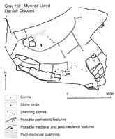
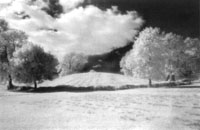
The Gray Hill Landscape Research Project is currently investigating the nature, scale and temporality of past human activity on Gray Hill, through six years of earthwork survey and targeted excavation. Staff and students from the University of Wales College, Newport are principally undertaking the project, although our co-director Helen Wickstead is from University College London. The project’s primary research aims are to map at more detail both existing and newly identified archaeological features, to characterise and date the D-shaped enclosure, and to identify evidence for any Mesolithic occupation. We also hope to identify, characterise and date later prehistoric settlement and agriculture, and to compare and contrast the prehistoric occupation on Gray Hill with that in the nearby Severn Estuary (e.g. Bell et al. 2000; Locock 1998a; 1998b). The project aims to build links with other institutions and local archaeology groups, and our work will also help to inform future land management and conservation strategies. We are also trying to explore and develop innovative, interpretative and self-critical fieldwork methodologies. On-going survey work is adding important detail to the known archaeology, and a new length of co-axial boundary has been identified to the east of the D-shaped enclosure, running towards a boulder-walled enclosure. Another new boulder-walled enclosure has been identified on the south-eastern flank of Gray Hill.
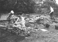
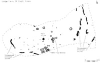
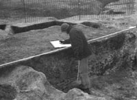
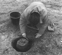
In June 2002 we excavated two trenches. Trench 2 (Trench 1 was not excavated after all) was located where there was a possible break or entrance through the D-shaped enclosure (Fig. 2). The first major phase of activity appears to have involved the building of a roughly east-west stone rubble bank up to 1.20 m in width, which may have had a gap or entrance at the western end of the trench. This was then used as a platform for the construction of an east-west stone wall 1 m in width. This survives elsewhere on Gray Hill to a height of over 1 m, but in this place it had been more comprehensively robbed. There were very large, rectangular facing blocks on the southern, presumably ‘outer’ face, whilst smaller, irregular stones seemed to ‘tie’ these larger blocks into a fabric of more tabular fragments. What is not yet clear is whether or not the stratigraphically earlier rubble bank was a separate phase, or merely a revetment for the larger stones. Though undated it is probable that these earlier phases were prehistoric. This part of the D-shaped enclosure appeared to be abutted by a roughly north south co-axial boundary, which further downslope was of double orthostat construction. Excavation revealed a right-angled section of faced and coursed drystone walling, whose corner appeared to respect the possible entrance through the rubble bank. This walling was of much more regular and evenly coursed stone, up to 0.70 m wide. The stratigraphic relationship between this wall and the more massive masonry could not be ascertained however, as subsequent disturbance had removed all the stone between the two sections of walling. Again, there were no finds to date either of the structures. In general form however, the north-south wall may be later in date than the more massive east-west example, which does not resemble any of the medieval and post-medieval boundaries on Gray Hill, and may thus be prehistoric. If this is indeed the case, then the north-south wall may itself be a rebuild of an earlier, double orthostat co-axial boundary. Rather than abutting the D-shaped enclosure, this may have been keyed into the earlier, wider wall. It appears much more ‘modern’ in form than the earlier east-west structures, and could be of medieval or post-medieval date. Demolition and robbing have created a clear gap in the ‘corner’ formed by the intersection of these two structures, and masonry from both walls was deliberately pushed over to the south-east and south to form a ‘ramp’ leading up to this gap. The larger stones were infilled with smaller fragments, and a metalled surface was created north of the gap. Both the north-south and the east-west walls seem to have been comprehensively robbed, presumably to facilitate livestock access in recent times. Clearly, more work is necessary to try and obtain dating evidence, and we will attempt to get secure material for radiocarbon or OSL dating. Future work in this area in 2003 will also establish if the rubble bank was a separate, early phase, and if there was an external ditch to the south, as indicated by shallow indentations in the modern ground surface.
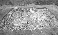
The second trench (Trench 3) was opened over what was thought to be a possible roundhouse or ring cairn. We established that the apparent ‘ring’ form was largely a product of later robbing, probably for a post-medieval wall some 30 m downslope to the south. This robbing had left much of the main body of the feature intact though. It proved to be a large stone cairn approximately 14 m in diameter, with its southern, downslope extent formed by a revetted bank of stone and earth still surviving to nearly 1.50 m in height. Further small ‘satellite’ cairns had also been added to the cairn. Two quadrants of the cairn have been investigated, and although not completed, they have already revealed intriguing details of the construction. In the northernmost quadrant (Fig. 3) three roughly equidistant, tabular slabs were recorded, which may have once stood upright. This raises the possibility that the cairn may originally have been a low stone circle, subsequently infilled with cairn material. Alternatively, this may have been a conscious architectural reference to such a form. At the centre of the cairn is a smaller, discrete pile of stone that may overlie central features. The wider landscape context of the cairn is also important. It lies on the southern flank of Gray Hill, south-east of the stone circle, and looks across the Severn estuary, where Bodmin is visible on clear days. A group of smaller cairns lies concealed in scrub just to the south. The north-south co-axial boundary in its double orthostat form runs downslope towards the cairn but kinks slightly and stops just before it, apparently respecting its position. Between this boundary and the main cairn is a smaller satellite cairn. The large cairn would have been a very prominent feature in the past, especially to people moving upslope from the south. Further work on the cairn in 2003 will investigate the central area of the cairn and explore details of its construction and origins, and examine the relationship between the main cairn, the satellite cairn and the linear co-axial boundary. It is partly because of these constructional complexities that we have been developing context sheets and ways of recording that try to engage with these ‘grammars of stone’ (Chadwick forthcoming). It is important that we recognise this complexity, so that we do not end up with the familiar but rather unsatisfactory metaphors of landscape palimpsests, with a series of features simply laid down upon one another, preserving static ‘pages’ from the past. Instead, we are working towards more nuanced accounts, that will acknowledge the dynamic and mutable nature of these constructions and human experiences of the landscape. In order to understand the materialities of people’s existence in the past, we need to examine more closely our own physical engagements with stone and earth. Our recording sheets therefore explicitly link observable physical traits with inferential, interpretative comments, and encourage excavators to be as self-critical and reflexive as possible. Through the intricacies of recording and interpreting stone and earth, we can begin to dissolve the artificial divide between archaeological theory and practice. When removing the stones that hands had placed there in the past, we must consider how and why people had selected and arranged these stones, and what these embodied, social acts of construction might have implied for ideas of identity, community, cosmology, memory, labour and power. Gray Hill is covered by bracken and stands of dense birch scrub, and is a challenging place to conduct survey and excavation. Yet the research potential of this upland Welsh landscape is great, and should allow us to examine settlement and subsistence practices, and to situate these within discussions of materiality and the relationships of past communities with the physical and cognitive aspects of their landscape. We hope the 2003 season will be as exciting as that of 2002. Adrian Chadwick, Joshua Pollard, Rick Peterson
and Mike Hamilton, Helen Wickstead, Acknowledgements References
|
|
In July 2002 a team from Cardiff University and the University of Manchester conducted a survey and preliminary excavation of the chambered tomb at Cairnderry in Dumfries and Galloway. The extent of the surviving cairn was exposed to the west of the monument and a length of kerb (5m) was exposed to the south of the monument. These excavations revealed that much of the cairn had been heavily robbed. Several courses of cairn stones remained in the majority of the exposed area but near the centre of the monument the cairn had been robbed to the level of the ground surface in some places. The interface between this ground surface and the topsoil where stones were absent contained clusters of potsherds which are probably earlier Neolithic in date, suggesting the presence of pre-cairn activity. Geophysics were also conducted at the site with poor results. This excavation marks the first stage in a longer project which will investigate the chambers, the passages and areas outside the kerb as well as the cairn and areas covered by the cairn. The ultimate aim of the project is to obtain material for radiocarbon dating and to understand the sequence of construction at the site. Project Directors: Dr Vicki Cummings (Cardiff University) and Dr Chris Fowler (University of Manchester).
|
| Ninth International Conference on Hunting & Gathering Societies (CHAGS 9). Hunter- Gatherer Studies & the Reshaping of Anthropology. Edinburgh Conference Centre, Heriot-Watt University, Edinburgh, 9th-13th September 2002 Hunter-gatherers have been a subject of anthropological
inquiry since the very beginning of the discipline. Since Man
the Hunter in 1966, several other conferences have been held
on hunting and gathering societies from a multidisciplinary perspective.
CHAGS 9, co-convened by Alan Barnard and Tim Ingold last September
in Edinburgh, was aimed specifically at reassessing the state of hunter-gatherer
studies in the context of the historical development of anthropology.
It has in fact succeeded by becoming a stimulating forum for such
a reassessment. This has been achieved through a wealth of theoretical
and historical discussions on the subject and the plurality of participants
from varying regions and traditions. Sebastián Muñoz and Mariana Mondini Univesidad de Buenos Aires
The Bronze Age Forum, University of Newcastle-upon-Tyne, 15-17th November 2002 The third meeting of the Bronze Age Forum occurred over
the weekend of the 15-17th November at the University of Newcastle-upon-Tyne
and was hosted by Joanna Brück, Frances Healy and Stuart Needham.
The forum began on Friday night with an informal wine reception held
at the highly appropriate location of the Museum of Antiquities. The
Forum was well attended with over a hundred delegates from all over
the British Isles and Ireland. This geographical diversity was also
reflected by the twenty-eight speakers.
|
| Readers of PAST may have been slightly
confused by Roger Thomas’s piece in issue
43, in which he stated that the Treasure Act 1996 had abolished
treasure trove. In fact the Treasure Act 1996 does not apply
in Scotland, where treasure trove continues to operate in an increasingly
systematic way to ensure the protection of all kinds of portable antiquities
(Saville 2002). In order to publicise the system in Scotland, and to make it easier for finders to report their discoveries, there is now a website (www.treasuretrove.org.uk) for Scottish treasure trove. The website explains how and why treasure trove operates, including an account of its legal basis in common law, and provides specific information for excavators, detectorists and other finders, and museum curators. The website is currently under further development to include a searchable database of items claimed as treasure trove. Meanwhile annual lists of claimed items and the museums to which they have been allocated continue to be published in each issue of the Council for Scottish Archaeology’s Discovery and Excavation in Scotland. Saville, A. 2002. Treasure Trove in Scotland. Antiquity 76, 796-802.
|
| A
PREHISTORIC CHILD WITH POSSIBLE LEPROSY |
| A recent discovery may change current perceptions
regarding the origins and spread of leprosy throughout the world. In
September 2002, 14 prehistoric burials from a site at Dryburn Bridge,
East Lothian, were re-analysed. The site, originally excavated in 1978
and 1979, showed evidence of an Iron Age settlement and contained both
Iron Age and Bronze Age burials. The ten Iron Age individuals were buried
in stone covered pits, whilst the four Bronze Age individuals comprised
two double burials in stone short cists. In both cists there was one
articulated burial that was overlain by a second,
disarticulated individual. One of these disarticulated skeletons was
the only child to be recovered from the site, and it was this individual
that displayed traits that are diagnostic of leprosy. Leprosy is a chronic
infectious disease of the skin, nasal tissues, peripheral nerves and
bone caused by the bacterium Mycobacteriurn leprae. The severity
of the condition can vary, but symptoms include ulceration and infection
of the skin and bones, particularly in the region of the nose and mouth
and lower legs, loss of spatial awareness, loss of sensation in the
limbs and extremities, claw hand and foot deformities and actual loss
of fingers and toes. The affected child was aged between six and eight
years at death and had previously been radiocarbon dated to between
2000 and 1600 years BC. Julie Roberts
|
|
We offer our apologies to Denise Telford for an error in the printing of Figure 5 of her paper The Mesolithic Inheritance, in PPS 68. This should show Mesolithic findspots but shows nothing at all! Investigations show that the problem was with the original digital artwork supplied by the author which looks fine on screen but refuses to plate correctly. Oddly (and rather embarrassingly), neither myself, the printers or the author spotted the error until the volume had been printed and distributed. Our apologies to Denise, and to our readers, for not being more vigilant. Correct copies are available from the author: denisetelford@hotmail.com
|
||
The Prehistoric Society’s last study tour to Northern Ireland was in 1967 some 36 years ago so we thought the time was right for another visit! The programme will include visits to sites in most of the region from the drumlin landscape of County Down, to the lakelands of County Fermanagh and the uplands of County Antrim. The range of sites will include megalithic tombs, the henge known as the Giant’s Ring outside Belfast, stone circles (including Beaghmore in County Tyrone) and the splendid ritual site of Navan fort in County Armagh. And although it is not ‘prehistoric’ a visit to the Antrim coast would not be complete without a visit to the Giant’s Causeway. Archaeologists from the Ulster Museum, Queen’s University and the Environment & Heritage Service (DoE) will provide the site tours and present the latest information. The programme is still being prepared, but if you would like to register your potential interest, contact our administrator, Tessa Machling, at the Society’s London address so that she can send out the details as soon as they are finalised.
|
|
| At the fiftieth birthday AGM of the Society in 1985, Bob Chapman raised several questions for future editors to ponder when they select articles for inclusion in our Proceedings (Chapman 1985, 27). In particular, he repeated Graham Clark’s concerns that ‘the proportion of later prehistoric papers, particularly on the Bronze and Iron Ages, had increased at the expense of papers dealing with the Palaeolithic and Mesolithic’ (Clark, 1959), and he queried whether the tendency in Vols 46-50 to concentrate on British sites would result in a reduction in overseas interest in PPS. Seventeen years on, it may be instructive look again at the contents of recent PPS volumes and try to find some indicators of the impact that these volumes have had on the archaeological community, both in the UK and abroad. Balance between Early and Later
Prehistory UK Perceptions Continental Perceptions John Cruse, Vice-President References
|
|
Part of a large
causewayed enclosure at St Osyth near Clacton has recently been excavated
by Essex County Council’s Field Archaeology Unit. The Neolithic
monument was an unexpected discovery, found prior to aggregate extraction
on a low spur of land, c. 4 km inland from the North Sea coast. The
area excavated (4.5 ha), consisted of a swathe across the centre of
the enclosure (Fig. 1), which also revealed features and finds from
other periods, including Bronze Age ring-ditches, and an extensive Middle
Iron Age settlement. Finance for the excavation came from the developer,
J.A. Lowe and Sons, Essex County Council and English Heritage (from
the Aggregates Levy Sustainability Fund). A detailed analysis of the
excavation has yet to be undertaken.
The ditches in all three circuits had
been constructed from large elongated pits joined end to end. They varied
in size and depth, from 1.15 m wide and 0.85 m deep, to 6 m wide and
1.5 m deep (Fig. 2). Where investigated, all of the pits appear to have
been contemporaneous. In several places there was evidence in plan for
the joining of existing pits by the removal of causeways.
By the Middle Iron Age it seems likely
that the significance of the causewayed enclosure had been lost, because
it was overlain by a large settlement of roundhouses, granaries, enclosures,
and granaries, which were laid out with complete disregard to the earlier
features. Mark Germany, Essex County Council Field Archaeology Unit References
|
|||
|
ARCHAEOLOGY & POPULAR CULTURE
- A RESEARCH QUESTION |
||
|
Clichés about archaeology abound widely in popular culture. They occur in films, TV documentaries, newspaper articles, literature, and various forms of advertising, but also in theme parks, modern art works, and the tourist industry. Archaeology and archaeologists tend to be portrayed as being primarily concerned with treasure hunting, field adventures in exotic places, collecting original artifacts, and comprehensive reconstructions of the past from tiny traces found beneath the surface. Archaeologists themselves have often felt uneasy about their image in popular culture. Some feel that a more realistic representation of the variety of archaeological practice would make a contribution not only to an improved public understanding of science but also to a better appreciation of archaeological artefacts and sites as part of our cultural heritage. A new project will now investigate this issue in some detail. As a Marie Curie-Fellow of the European Commission I am based at the Swedish National Heritage Board (Riksantikvarieämbetet) in Stockholm and will study in some detail if and how the popular characterisations of archaeology stand in the way of promoting our cultural heritage or not. In effect, I will be asking a broad question of considerable social and political relevance within the emerging field of ‘public archaeology’. In order to give the results wider relevance, a comparative perspective will be chosen and fieldwork will be conducted in Sweden, the United Kingdom, and Germany. My research will be conducted in two phases. During the first phase I will gather a portfolio of evidence for the popular image of archaeology in all three countries. This material will then be analysed for each country and the results compared. In a second phase, I will evaluate how archaeology is portrayed against various possible aims of both archaeology in general and archaeological heritage management in particular, before reaching a concluding assessment. The project began in October 2002 and will last until September 2004. Now would be the best time for anybody with relevant experiences or passionate views on this subject to contact me and see that their views are represented in my study! If you know of any particularly interesting or unexpected appearances of archaeology in popular culture, or if you have strong opinions about the usefulness (or uselessness) of the popular image of archaeology, I would very much welcome to hear from you irrespective whether this concerns the three countries mentioned or any others. Dr Cornelius Holtorf, Riksantikvarieämbetet,
|
||
| Crossings: the prehistory
of the Channel region 20.9.03
European Association of Archaeologists annual
meeting 10.9.03 - 14.9.03
Exploring the Maltese Prehistoric Temple
Culture 25.9.03 - 27.9.03
|
||||||||||||||
| |
The Prehistoric Society Home Page |