PAST
Registered Office University College London, Institute of Archaeology, 31-34 Gordon Square, London WC1H 0PY


NUMBER 42 NOVEMBER 2002

TRANSITIONS TO FARMING IN THE SAHARA: THE SOCIETY'S STUDY TOUR TO LIBYA, 14-21 OCTOBER 2002
 

Figure 1
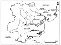
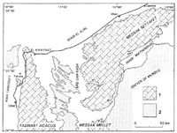
Figure 1. Southwest Libya, showing the main focus of the Society's Libya tour, from Germa (top right) to the Tadrart Acacus mountains (bottom left), then east across the Erg Uan Kasa sand sea and along the southern edge of the Messak Settafet to Wadi Mathendusch, and back to Germa.

          The Society's 2002 Study Tour was to Libya, specifically to see the rich archaeology of the province of Fezzan in the southwest, deep in the Sahara (Figure 1). When I first proposed the Libya trip to Council a few years ago I had no idea I would be the Society's President when it finally came to fruition, but I always hoped to be part of such a tour. Although I have worked extensively in Libya, I have never been to the far southwest to see the wonderful rock art there, the rock paintings of the Tadrart Acacus mountains and the rock engravings of the Messak Settafet plateau, which were to be the highlights of the tour. The other reason I proposed the tour was that my Leicester colleague David Mattingly was running a large multi-period survey and excavation project (the Fezzan Project: Mattingly, 2000), so it seemed an ideal opportunity to use his expertise! David and I were the lecturers on the trip, with Dr Isobel Sjöström (an experienced Saharan archaeologist who has worked on a number of Libyan and Sudanese field projects) the Andante Representative. The student place was awarded to Michael Rainsbury, who has just completed a Masters in Prehistoric Rock Art at Durham (and who has strict orders to write something for PAST in due course!). We gathered at Heathrow in the wee small hours of Monday 14 October, and by the afternoon, via Amsterdam, we were all in the Libyan capital Tripoli. We were very ably looked after in Libya by Abdul Heba, the Representative of Winzrik Tourism Services, the local travel company who were working with Andante on the tour arrangements. We walked round Tripoli's Medina (Old City) in the falling light, and everybody was taking sweet minted Libyan tea in the shadow of the Old Castle (Tripoli's finest historic monument, now housing the National Museum and the Department of Antiquities) as the muezzin called out through the dusk - we had thoroughly arrived.

Figure 2
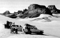
Figure 2. The summit of the Takhakhouri Pass in the Tadrart Acacus.

          The overarching theme of the study tour was the transition from foraging to farming in the Sahara, with the tour arranged in chronological reverse order. On the morning of the second day we flew south to Sebha, the capital town of Fezzan, where our party was divided between five battered Toyota Landcruisers, and we spent the rest of the day working our way southwest down the Wadi el Ajal oasis visiting Garamantian sites investigated by David's project. The Garamantes were a remarkably complex state-organised society that controlled Fezzan in classical times, trading variously with the Punic and Roman world to the north, the Egyptians to the east, and the Sahel peoples on the southern side of the Sahara. David showed 
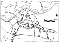
us round his major excavations of the ancient city of Germa, the Garamantian capital, where he has exposed a continuous stratigraphic sequence from 
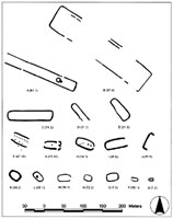
c.500 BC to the present day. We also looked at Garamantian tombs (there are estimated to be over 100,000 down the wadi), and foggaras, the underground water channels once thought to be Islamic in date but which his project has shown convincingly were in fact a Garamantian technology, the basis of the intensive oasis farming that sustained their state. In the falling 
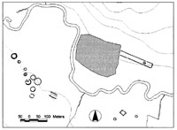
light we scrambled over the hilltop fortress of Zinchecra a few kilometres from Germa, where excavations by Charles Daniels in the 1960s revealed evidence for complex protohistoric sedentary societies, the beginnings of the Garamantian state system, c.1000-500 BC. That evening we slept in a hostel belonging to Winzrik, where we also picked up our camping gear and the kitchen truck that was to accompany us on the desert trip. The final member of the party was a charming member of the Libyan security services (one accompanies every tourist group), who had never been into Fezzan before and turned out to be the keenest tourist of all of us.


Figure 3
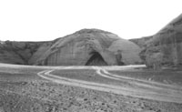
Figure 3. Uan Afuda cave.

          On the morning of the third day we travelled into the Ubari sand sea on the northern side of the Wadi el Ajal oasis to visit some extraordinary relict lakes there which the Fezzan Project has shown were foci of settlement for Mesolithic foragers and Neolithic forager-herders. This visit also introduced the party to the way you have to drive across sand dunes: charge full tilt (slipping back down if you don't make the top) but crucially manage to stop on the crest, so you can see whether you can get down the other side without taking off if the slope on the far side turns out to be vertical. We managed to visit some spectacular mudbrick Garamantian pyramid tombs under restoration by the Department of Antiquities, before setting off on the long road journey southwest towards the desert settlement of El Uwaynat near the Algerian border at the top of the Tadrart Acacus mountains, where we were meant to be heading off road. However, we had some long delays from bad punctures to the kitchen truck, and we eventually made our first camp in the dark in a bowl in the sand dunes (our drivers always chose these, to be out of the wind). With some trepidation I watched some well-known Society members reading by the light of the car headlights their instructions about how to assemble the new tents they had been given. There were anguished cries of 'I haven't done this for 20/30/40/50/60 years! [tick number of years as appropriate!]

Figure 4
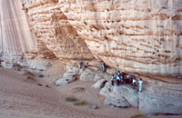
Figure 4. Society members examining rock art in the Wadi Teshuinat (Tadrart Acacus).

          We almost had a major logistic crisis the next day, because there turned out to be no petrol in El Uwaynat and our desert journey needed all the vehicle tanks full as well as the dozen or so jerry cans we also carried. Abdul and the security agent even tried the local army garrison, but got a dusty answer. The previous petrol station was 200 kilometres back, but the word on the Al-Uwaynat street (it only has one) was that there 'probably was' petrol 100 kilometres further south in Ghat, the last settlement before the Algerian and Niger borders. So we kept on down the asphalt road to Ghat, and - eventually - there was. We also filled up with water here - we could really only carry what we needed for drinking and cooking, so we all had to get used to washing with less than a pint of water per day per person. By detouring to Ghat we were on the western side of the Tadrart Acacus mountains, whereas the archaeology is all on the eastern side, so we had to make a long detour south as far as the border zone with Algeria, then cross the spectacular Takhakhouri Pass (Figure 2), the vehicles repeatedly having to gain height up every incline crawling through slushy 'fesh-fesh' sand, and falling back repeatedly, before finally making the summit.
          The Tadrart Acacus has been the focus of research by Italian scholars over many decades, the rock art studies being pioneering especially by Fabrizio Mori (1960, 1965). More recently this work has been augmented by some outstanding inter-disciplinary survey and excavation programmes, most recently by Mauro Cremaschi and Salvino di Lernia in and around the Wadi Teshuinat (Cremaschi and di Lernia, 1998). The traditional theory about the transition from foraging to herding in the Sahara has been that Neolithic colonists spread westwards from the Nile valley c.4000 BC, bringing pottery, domestic animals and plants with them, but the Italian work, especially in the Wadi Teshuinat that was the main focus of our visit to the Tadrart Acacus, demonstrates a very different scenario, of Mesolithic foragers changing to herding in the context of desiccation (Barker 2002, in press).

Figure 5
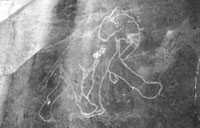
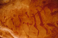
Figure 5. A handsome engraving of an elephant, a typical example of the 'Bubaline' or 'Big Game' style of rock art in the Tadrart Acacus thought to have been carved by early Holocene foragers.

          Their palaeoenvironmental studies have shown how the region (as elsewhere in the Sahara) was ultra-arid in the late Pleistocene, and effectively uninhabited, but the transition to the Holocene introduced conditions dramatically wetter than today - rainfall has been estimated variously at 10-15 times modern levels - allowing people to colonize the region once more. On the evidence of excavations in caves such as Uan Afuda, one of the highlights of our visit (Figure 3), these early Holocene foragers collected grasses and wild cereals (sorghum and millet), fished, and hunted riverine animals including crocodile, hippopotamus and turtle and savanna animals such as large and small antelopes, though the main quarry was the Barbary sheep. At Uan Afuda di Lernia and Cremaschi have also found extraordinary evidence for the management of the latter species 1000 years before the appearance of domestic cattle, sheep and goats. Their evidence is very convincing: they found clear structural and micromorphological evidence for stalling, and the Barbary sheep coprolites have partially-ground grass seeds in them. This remarkable evidence for 'pre-herding herding' at Uan Afuda coincides with climatic evidence for a sudden onset of dryness, so the onset of desiccation appears to have been the context for significant shifts in behaviour.

Figure 6
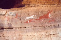
Figure 6. Hunting a Barbary sheep - a typical example of Saharan 'Pastoral Neolithic' rock art in the Wadi Teshuinat.

          There is evidence of a wetter oscillation in the mid Holocene, but the overall trend was to aridity, which seems to have been the critical context in which the indigenous populations developed an increasing commitment to pastoralism. We visited one of the best known 'Pastoral Neolithic' sites in the Sahara, Uan Muhuggiag (a few kilometres from Uan Afuda), where excavations by Mori showed that people were herding domestic cattle, sheep and goats by the fifth millennium BC, combining pastoralism with hunting, fishing, and gathering. The site is also notable because Mori found fragments of painted rock that had fallen from painted images on the walls of the rock shelter into occupation deposits below dated to about 3000 BC. This association is still one of the best pieces of dating evidence we have for Saharan 'pastoralist' rock art. The Wadi Teshuinat has examples (in the hundreds) of all the main styles of Saharan rock art, which is either engraved/incised into the rock, or painted in reds and whites (Figure 4). Engravings of big isolated wild animals like elephant (Figure 5), giraffe, rhinoceros, buffalo, and crocodile (the so-called Big Game or Bubaline phase) are assumed to have been carved by hunters in the early Holocene humid phase. At the other end of the sequence are painted images of people using horses, chariots, and camels, and recognisable signs of Egyptian-type culture, generally thought to be of Garamantian date. In between is the rest of the art, consisting of carvings and especially paintings of herding and hunting scenes made by the forager-herder peoples of the Sahara between c.5000 and 1000 BC. They clearly are 'scenes', too, like the Wadi Teshuinat image of a Barbary sheep being pursued by dogs and hunters (Figure 6).

Figure 7
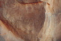
Figure 7. An engraved scene of a herd of cattle, typical of Saharan 'Pastoral Neolithic' rock art in the Wadi Mathendusc.

          From the Tadrart Acacus we travelled eastwards across the Erg Uan Kasa sand sea (another desert campsite) and then crossed the Messak Settafet, a featureless rock-strewn upland covered in tyre-puncturing rubble and - in enormous profusion - prehistoric stone tools (we had ten punctures in the total trip, in fact). The Messak Settafet is cut by numerous wadi channels, most of which contain examples of engraved rock art, but the main focus of our visit was the best known and most spectacular collection, in the Wadi Mathendusc. The Messak was part of the seasonal grazing schedule of Neolithic pastoralists, who carved hunting and herding scenes on major exposed rock faces quite unlike the rather secretive locations of the Tadradt Acacus paintings. On our last two days in Fezzan we saw fine carvings of herds of cattle (Figure 7) and sheep, including milking scenes, and of wild animals like ostriches and giraffes being caught in enclosures or trapped with thongs attached to heavy rocks - hundreds of these 'trapping stones' still litter the Messak.

Figure 8
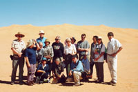
Figure 8. The Society's intrepid Libya Study Tour group. Our principal lecturer David Mattingly is in the front row on the right.

          Visiting the National Museum (opened specially for us) on the last morning before the flight home, it was clear how much of the best of Libya's desert archaeology we had managed to pack into our short week. We saw wonderful archaeology that is still visited by very few Europeans, and spectacular and varied desert scenery. We crossed some of the most demanding vehicle terrain in the world, which even with all the support of modern technology is still very challenging. The Society's members (Figure 8) proved wonderfully intrepid campers and travellers, and delightful companions. Our Libyan guides and drivers were enormous fun as well as doing everything to keep us safe, always totally at ease in what was a very alien environment to most of our group. (Well versed in European sensitivities, our lead driver carefully slaughtered and gutted our last night's supper out of sight behind his vehicle at the final desert camp. And that was after we had thrashed around the desert in darkness for a couple of hours looking for the kitchen truck that had set up camp behind the wrong sand dune!) I am sure I speak for all the Society's members on this memorable Study Tour that it was a privilege to be in their desert, in their company.

Graeme Barker,
University of Leicester,
(President, Prehistoric Society)

gba@le.ac.uk

Reference
Barker, G., 2002, in press, 'Transitions to farming and pastoralism in North Africa', in C. Renfrew and K. Boyd (eds) Examining the Farming/Language Dispersal Hypothesis, Cambridge, McDonald Institute.
Cremaschi, M., and di Lernia, S., 1998, eds, Wadi Teshuinat: Palaeoenvironment and Prehistory in South-western Fezzan (Libyan Sahara), Florence, Insegna del Giglio.
Mattingly, D., 2000, 'Twelve thousand years of human adaptation in Fezzan (Libyan Sahara), in G. Barker and D. Gilbertson, eds, The Archaeology of Drylands: Living at the Margin, London, Routledge, One World Archaeology 39, pp. 160-79.
Mori, F., 1960, Arte Preistorica del Sahara Libico, Rome, De Luca.
Mori, F., 1965, Tadrart Acacus, Turin, Einaudi.


AN UNUSUAL ROCK ART SITE IN SOUTHERN MOROCCO
 

Figure 1
Figure 1. Two archers followed by giraffe and line of ostriches

        Within the framework of its research programme, the Fondation Cheikh Ma el Ainine pour la Conservation du Patrimoine de Smara (of which I am an honorary member) recently invited us to visit and publish a newly discovered rock art site in southern Morocco. The site is situated some 130 km SE of the pre-Saharan town of Tan-Tan, itself about 360 km south of Agadir. In this short article, only the main features are described pending further research.
        A 2-hour drive in a Land Rover, kindly provided by the Gouvernor of Tan-Tan province, much of it in the sandy bed of an ancient river, was necessary to reach the site, near the well of Hassi Laouinate. Expecting to find a site with engravings, we were astonished to be taken to a small, shallow cave with numerous red ochre paintings. Only 12 sites with paintings have as yet been discovered in Morocco and their contents are limited to 1st millennium bc Libyco-Berber, stick-figure horsemen, tifinagh inscriptions or confused whorls and wavy lines.
        This was not the case at Laouinate. The most striking images were paintings of six men armed with bows and seven other similar figures (without bows). The largest of these figures measured 32 cm. A central scene, visible when lying on one's back looking at the cave roof less than a metre away, was made up of a line of ostriches and a giraffe following two archers (each with penis and testicules) holding hands (Figure 1). The two archers faced two other similar figures, one sexed and carrying a bow. The cave also contained numerous smaller anthropomorphic figures and several animals. A sheep, three antelopes, two bovids, a giraffe and five to six ostriches could be clearly identified. Other figures were rather obscure.
        No rock art site in Morocco has paintings of this type. These human figures, with their oval heads, very prominent buttocks and powerful thighs, recalled at once the second or third millennium paintings of the central Sahara, although we could not immediately link them to any known Saharan school of paintings. However, two painted chariots, typologically similar to the engraved chariots fairly frequent in Morocco, which - according to Muzzolini (1998: 385) - were introduced to the Sahara in the first half of the 1st millennium bc, were a disconcerting element among these steatopygous human figures. Our first reaction was to place these chariots later than the archers. Further reflexion led to the alternative possibility of an earlier age for the chariots, as proposed by Camps (1993: 1887). Some superpositions of paintings indicated at least two periods for the paintings. Further study on the site is under way

Susan Searight

References
Camps, G, 1993. Chars (art rupestre), Encyclopédie berbére XII: 1877-1892, Edisud, France
Muzzolini, A. 1998. Les images rupestres du Sahara. 447 pp. Toulouse, France


FLOODS AT THE INSTITUTE OF ARCHAEOLOGY, PRAGUE
This Summer's floods have caused severe problems at the Institute of Archaeology. The images for the previous article are now some of the few which survive since they were saved from the floods by virtue of being in the post to us. Much else has been destroyed and there are several sources in Britain which are acting to help our Czech colleagues. This report has been put together by the editor, drawing on information provided by the Institute website (http://www.arup.cas.cz), Vincent Megaw, Pat Foster, Martin Kuna, Council for British Archaeology, and English Heritage.
 

Figure 1
Figure 1. The Institute of Archaeology in Prague, (circled) during the floods
(Source: Institute website)

         On August 13th 2003 several of the major river systems of the Czech Republic began to overflow and within forty-eight hours many had reached unprecedented flood levels. There was no warning that unusually high levels were to be expected. The Vlatva river, which runs through Prague, flooded the old city center, an area in which the Institute of Archaeology is housed, by up to three meters. The ground floor and any cellar stores were all completely submerged. These rooms held the Institute`s library of over 70,000 books, journals and papers (mostly destroyed); the photographic archive (200,000 negatives, mostly destroyed); the excavation drawing archive (severely damaged); scientific laboratories (mostly destroyed) and most of the stores held excavated material packed in paper bags (up to 25% lost, either disintegrated or context information lost). The floodwaters were highly contaminated from the cities sewerage system and a variety of chemicals from local factories and chemical works. Rat and mice urine introduced a virulent bacteriological danger. All materials, finds, equipment etc had to be washed and disinfected. The Institute received little official help from the emergency services at this time archaeology apparently being a low priority.

Figure 2
Figure 2. The flods of up to 3m affected the library and archives of maps, plans and photos gathered over more than a century.
(Source: Institute website)

         News of the disaster was rapidly broadcast throughout the international archaeological community by our many friends and colleagues around the world. A short report has been inserted in the Institute's web site and an appeal poster has been produced and distributed. Nothing however can compare with being a part of the actual events and it is difficult to describe the true magnitude of the disaster. Members of the Institute worked for several weeks, late into the night trying to save as much as possible. Finally everyone was sent home, totally exhausted, and the Institute was closed until electricity could be restored. One month after the disaster the electricity came back, but it is more difficult to restore the depressive mental damage that has been inflicted. Many members have lost decades of work and are still stunned. It is heart breaking to walk around the rooms now. Everything was stripped out of them and the corridors and the whole ground floor is now a bare empty shell. All that remains of the new library rack system is the metal rails set in the concrete of the floor. All that remains of the library are the 10,000 books, frozen and stored to await some expert advice (miraculously almost instantly supplied by experts from Denmark). Perhaps the greatest loss, since one picture is worth a thousand words, was the photographic archive. Accumulated over the past century this unique and irreplaceable archive of prints and, glass and plastic slides was totally erased. Of almost equal loss was the great library of the Institute. The library was one of the largest and most comprehensive archaeological information resources in Central Europe and the loss of this tool to researchers and students cannot be estimated. Unlike the photographic archive, however, it can be replaced with the help of all those who love and practice archaeology.
         It has to be recognized that archaeology takes a low political and economical priority at this time and as someone who is an archaeologist, who has also lost his home to the river for the forseeable future I see the reasonableness for this attitude. Many hundreds of people, families and individuals have lost their homes and possessions completely. Many villages around the countryside have been reduced to hamlets and the authorities must help them first. For these reasons the archaeology of the Czech Republic is asking for international help.

Pat Foster
Prague

Help from the UK
         The CBA has launched an appeal to help raise funds for the restoration of the building, equipment and library. Donations can be made through the CBA by cheques payable to the 'CBA Prague account' sent to CBA, Bowes Morrell House, 111Wlamgate, York YO1 9WA, or teelphone them to make a credit card donation, tel 01904 761417.
         Sue Cole has been seconded from English Heritage for 3 months to the International Committee of the Blue Shield based in the British Library to help co-ordinate the UK response to the damage to cultural heritage following the recent floods in the Czech Republic and Germany. Cultural heritage is defined as including the built environment, archives, libraries. The project will identify the needs and assess what resources (cash, people and facilities) are available in the UK and where possible match the two together; identify what has been given internationally and where the gaps are (and if possible plug them); draw up a database of key contacts and addresses; put forward proposals for strategy to co-ordinate future disasters/emergencies. So far the UK response on cultural heritage has been £100k towards the costs of conservation of the archives - 3 vacuum drying machines have been purchased together with bags and some storage equipment. Possible initiatives to help rebuild the destroyed collections and archives include collecting spare or surplus books and journals, and other reference materials such as collections of pollen, animal bone or plant remains. Anyone who may have information or resources that may be of help to the UK response effort should contact Sue Cole on: floods2002@bl.uk or sue.cole@english-heritage.org.uk.
         The Prehistoric Society has been asked to donate a set of its Proceedings and will do so. However, a number of previous volumes are now out of print. If any members have copies of the following volumes which they would be willing to donate for this purpose, please would they contact our administrator Tessa Machling, (see front cover) who will be co-ordinating the Society's response. The missing volumes are: Vols 4, 6, 15, 24, 26, 27, 28, 29, 31, 33, 57.2, 64.


JOUSTING AT WINDMILLS IN CONSTABLE COUNTRY
 

Figure 1
Figure 1. Location plan showing Stour valley and four sites investigated by the Cropmark Enclosures Project.

         The problems of dating and classifying cropmark enclosures on the basis of cropmark morphology alone are well known. In the late 1990s the Essex Cropmark Enclosures Project, with funding from English Heritage, examined four circular cropmark enclosures: Colemans Farm, Rivenhall; Sturrick Farm, Great Bentley; Hall Farm, Little Bentley; and Clare Downs Farm, Belchamp St. Paul (Figure 1). Two had long been regarded as probable henges (Great Bentley and Little Bentley) and one as a possible hengiform monument (Rivenhall). The fourth site (Belchamp St. Paul), was seen as a probable barrow, but had also been interpreted as a possible henge or Springfield type monument of Late Bronze Age date.

Figure 2
Figure 2. Selection of elongated monuments in the Stour Valley, including the cursus monuments at Bures St. Mary (A), and Stratford St. Mary (B) Long Mortuary enclosures/Long Barrows (C-J), Oval barrows (K-Q). The location of the Bures cursus (A) and the open-ended monument defined by flanking ditches with internal pits/postholes (F) are shown in Figure 3.

         The enclosures at Belchamp St. Paul, Great Bentley and Little Bentley were fieldwalked and trial-trenched, and the enclosure at Rivenhall, one of a group of monuments including a Long Mortuary Enclosure, which had been fieldwalked in 1986 (Buckley et a1. 1988), was trial-trenched. In addition at two sites (Rivenhall and Belchamp St Paul), the opportunity was taken to sample alluvial/colluvial sequences close to the cropmarks. The Rivenhall enclosure yielded Neolithic flintwork, and the Belchamp St Paul Late Neolithic and Early Bronze Age flintwork and pottery. By contrast both the Great and Little Bentley sites produced early medieval pottery and appear to be windmill sites. Both these sites were included on a map accompanying a recent discussion of the later Neolithic; indeed the Little Bentley cropmark has long been considered amongst the most likely cropmark henges in eastern England, and frequently discussed as such ( e.g. Harding 1995, Holgate 1996). This clearly indicates the necessity for careful characterisation of cropmark evidence: developing explanations of the Neolithic is difficult enough without inadvertently attempting to accommodate medieval sites. At Rivenhall, sampling of the valley of a small stream immediately adjacent to the cropmark enclosure, revealed a deep sequence of alluvial and colluvial deposits, containing a variety of environmental deposits. Much of the sequence was contemporary with construction and use of the Rivenhall monuments, enabling something of their changing landscape setting to be discussed. Similar deposits were sampled adjacent to the Stour close to the Belchamp cropmarks.

Figure 3
Figure 3. The cursus at Bures St. Mary (the hatched area showing gravel extraction) and a linear monument complex at Mount Bures to the south of the river. Both the cursus and the linear monument complex run along the 20m contour and appear to "cut-off", or enclose, meanders in the river.

         The cropmarks at Belchamp St. Paul are part of a remarkable series of cropmark monument complexes in the Stour valley, which forms the boundary between Essex and Suffolk, the heart of Constable country. The cropmarks include two cursuses (Figure 2) a wide variety of ring-ditches and other monuments together with extensive areas of fields and trackways. This cropmark landscape is well known locally, but perhaps not so widely appreciated at a national level as they deserve to be. An English Heritage funded project to prepare a GIS based synthesis of the Stour cropmarks has recently been completed.The proposal for the Stour Valley Project arose from preparation of the Eastern Counties Regional Research Framework (Glazebrook 1997; Brown and Glazebrook 2000). It was designed to provide a synthesis and interpretation of the existing cropmark data. This was intended as the first step towards developing a collective approach involving all those with an interest in the archaeology of the Stour valley, as part of a longer-term programme to enhance understanding and management of the cropmark landscape. The work of the National Mapping Programme (NMP) formed the foundation of the cropmark synthesis, and the project was funded by English Heritage as part of the implementation of the Monuments at Risk Survey.

Figure 4
Figure 4. The cropmark complex at Lawford. Fields/enclosures around a large monument complex in the bottom of the valley are linked by a series of trackways to higher ground to the south.

         The cropmarks often show a close relationship to the Stour. Monument complexes are frequently set within river meanders, or they may develop as linear sequences running across the necks of meanders (Figure 3). Amongst the systems of fields and trackways in the valley is an example at Lawford, long considered to be of Bronze Age origin and deeply embedded in the literature as such. Here, a monument complex (the only Scheduled Monument complex in the valley) is enclosed within a large rectangular field. This enclosure is one of a number which are linked to a series of trackways (Figure 4) leading from the river floodplain to the valley side which here forms a steep scarp leading to the flat top of the Tendring plateau. Again there seems a clear logic to this field system linking the valley floor pasture to higher ground to the south. The cropmark fields and trackways at Lawford are unlikely to be the creation of a single period. A rather similar cropmark system of trackways and rectilinear enclosures associated with large ring-ditch cemeteries has been extensively excavated at Ardleigh, 5km southwest of Lawford. Here, the earliest phase of land division clearly belonged to the Early/Middle Bronze Age, and the system of trackways changed and developed throughout the Iron Age and Roman periods. Indeed some elements appear to survive as features in the present landscape (Brown 1999).
         The first phase of the Stour valley project has provided a firm basis for developing understanding and management of the cropmarks in the valley. It is hoped that the cropmarks can be incorporated into existing schemes of management, which have for many years ensured the maintenance and enhancement of nature conservation and other aspects of the valley landscape. Such an approach will be a significant contribution to a sustainable management to the valley landscape. It is also intended that future field investigation will address the phasing and development of the cropmarks in conjunction with further environmental sampling. In this way a clearer understanding of the 'immensely old' landscape preserved within the Stour valley can be developed. A full report on the Cropmark Enclosures project will appear in volume 33 of the journal Essex Archaeology and History, a report on the first phase of the Stour Valley Project has been submitted to the journal Landscape History.

N. Brown, D. Knopp and D. Strachan

References:
Buckley, D. G., Major, H. and Milton, B. 1988. Excavation of a possible Neolithic long Barrow or Mortuary enclosure at Rivenhall, Essex, 1986. Proceedings of the Prehistoric Society 54, 77-91.
Brown, N. 1999. The Archaeology of Ardleigh, Essex: excavations 1955-1980. East Anglian Archaeology 90, Chelmsford.
Brown, N. and Glazebrook, J. (eds.) 2000. Research and Archaeology: a Framework for the Eastern Counties: 2 Research Agenda and Strategy. East Anglian Archaeology Occasional Paper 8.
Glazebrook, J. 1997. Research and Archaeology: a Framework for the Eastern Counties: 1 Resource Assessment. East Anglian Archaeology Occasional Paper 3.
Harding, J. 1995. Social histories and regional perspectives in the Neolithic of lowland England. Proceedings of the Prehistoric Society 61, 117 -136.
Holgate, R. 1996. Essex c. 4000-1500 BC. in Bedwin, 0. (ed.) The Archaeology of Essex: Proceedings of the Writtle Conference 15-25. Essex County Council, Chelmsford.


PREHISTORIAN HONOURED
 

        Dr John Wymer has been awarded the Grahame Clark Medal of the British Academy. The medal is awarded every two years, and past recipients have included Stuart Piggott, and Desmond Clark. The medal is presented on the basis of 'distinguished achievements involving recent contributions to the study of prehistoric archaeology'.
         John Wymer is Britain's foremost authority on the earlier Stone Age settlement of the United Kingdom. He has spent 40 years in a variety of investigations of Palaeolithic and Mesolithic sites in Britain, using a combination of excavations, field surveys and environmental studies. His work in southern Britain on sites such as Hoxne and Clacton has now been expanded into a magisterial two-volume publication on The Lower Palaeolithic Occupation of Britain. Dr Wymer has also carried out major programmes of research in South Africa, most notably at Klasies River Mouth, the results of which have been of worldwide significance. A particular aspect of Dr Wymer's research has been his willingness to share new and unpublished data to all those who work on related fields. This generosity has been widely appreciated at all levels of scholarship, from lowly research students to established professors. Dr Wymer's influence upon the development of Stone Age studies in western Europe continues to be widely recognised, and his earlier contacts with Sir Grahame Clark were acknowledged by Sir Grahame in his world surveys of prehistory. The award of the Grahame Clark Medal is an appropriate acknowledgement of Dr. Wymer's enormous contribution to the study of the early palaeolithic in the Old World.
         John Wymer is often seen at Prehistoric Society events and it is good to see his important contribution acknowledged. Well done John!


CLARE ISOBEL FELL, M.A., F.S.A. , 10th October 1912 - 17th July 2002
 

        For much of the latter half of the twentieth century thearchaeological world in Cumbria was dominated by the graceful yet forceful figure of Clare Fell, the prehistorian who first drew attention to the Neolithic axe factory at Langdale in the heart of the Lake District, a discovery which led to revolutionary work on Neolithic trade routes in Britain. A true scholar, Clare Fell was for many years the lynchpin of the Cumberland & Westmorland Antiquarian & Archaeological Society. Under her leadership, archaeology in Cumbria prospered, as the complementary strengths of professionals and amateurs were recognized, encouraged and brought together.
         Clare Isobel Fell died at Sandside, Cumbria, on 17 July 2002 in her ninetieth year. She was born on 10 October 1912 at Ulverston, the third of the four children of Sir Matthew Henry Gregson Fell and his wife, Marion Isobel (nee Wallace). After schooling at Harrogate College, she went up to Newnham College, Cambridge, in 1931 to read Economics but did not enjoy the subject and changed to Archaeology and Anthropology at the suggestion of her Director of Studies, because of her family connection with the Cumberland & Westmorland Antiquarian & Archaeological Society. She obtained a First in Section A of the Archaeology and Anthropology Tripos in 1933, but because women were not allowed to take degrees at that time, she did not receive her M.A. until 1948.
         She remained at Cambridge until 1953, her career there being interrupted by service as an ambulance driver in the A.T.S.during the Second World War. Returning to Cambridge, she catalogued Lord Braybrook's collection of antiquities, which had been given to the Museum of Archaeology and Anthropology in 1947, and became Assistant Curator of the Museum under the newly promoted Geoffrey Bushnell. In the summer of 1949 she joined the first season of excavation of the Mesolithic site at Star Carr being excavated by Grahame Clark and in September of that year began her work on the axe factory at Langdale. In the1950s she again worked with Grahame Clark at West Harling in Norfolk, where the work on late prehistoric settlement archaeology is widely acknowledged as one of her major achievements outside Cumbria. In 1951 she was elected a Fellow of the Society of Antiquaries of London and she also served on the Council of the Prehistoric Society. In 1952-53 she was Secretary of the Faculty Board of Archaeology and Anthropology, and in the same year joined the Third Foundation Association which, in 1954, founded New Hall as the third women's college.
         In 1953 she left Cambridge to look after her ageing parents at Flan How, Ulverston, and from that time her archaeological interests were centred on Cumbria, where she came to play a leading role in the Cumberland & Westmorland Antiquarian & Archaeological Society, of which she had been a member since before the War. She was elected to the Society's Council in 1945, joining her father among the vice-presidents in 1957, and serving as president from 1963 to the Society's centenary year in 1966. A steady stream of papers in the Society's Transactions made a major contribution to the knowledge of Cumbrian prehistory, always keeping abreast of advances in scientific techniques. Her association with Winifred Tutin (Pennington) in the study of the effects of man on the environment, resulted in pioneering pollen analyses for prehistoric artefact layers from sites in Cumbria. Her papers, like her lectures, were models ofscholarly clarity, as was her short, accessible paperback volume, Early Settlement in the Lake Counties (Dalesman, 1972).
         It is perhaps her work on the Langdale axe factory site for which she was best known. She published the first mention of the axe factory as a note in CWAAS Transactions in 1948, following this with more detailed accounts, jointly with Brian Bunch in 1949 in the Proceedings of the Prehistoric Society and in 1950 in CWAAS Transactions. Her view that there would be other workings wherever the volcanic tuff outcropped has been proved correct and it was largely due to her efforts that a field survey was carried out by Chris Houlder, the results of which were published in 1979. Her work in co-operation with Dr Vin Davis on the petrological identification of stone implements from Cumbria broke completely new ground and led the way for all subsequent work in Great Britain and Ireland. Not long before her death she was considering, with Dr Davis, the re-evaluation of stone implements using geochemical and computer analysis. Her research on the distribution of stone implements set a high standard for other scholars and was maintained for all her life. When a more comprehensive study of the Langdale axe factory by Professor Richard Bradley and Dr Mark Edmonds was carried out using all the latest available techniques, the report, published in 1993, was dedicated to Clare, as a tribute to her kindness and encouragement.
         Clare Fell was held in great affection by the archaeological fraternity in Cumbria. She played a unique role, giving freely of her time, sharing her encyclopaedic memory, encouraging amateur field workers and quietly fostering the furtherance of prehistoric studies in the region, not least through her long service (for many years as chairman) of the CWAAS Fieldwork and Excavation Committee and its forerunners, service which spanned the years 1937 to 1982. She had a particular concern for young people, encouraging youthful interest in archaeology, befriending and supporting young professional archaeologists and their families, welcoming the children of CWAAS members who joined the annual archaeological 'fell walks' she organized each May for many years. She is remembered for her warmth, her wit and her smiling eyes; her stately presence enlivening the gatherings of the Society to which she contributed so much.
         In 1967 she moved to Sandside, overlooking the Kent estuary at the head of Morecambe Bay, latterly sharing her home with her long-term companion, Lowry Hart-Jackson, who died earlier this year.

James Cherry
Angus J L Winchester.


SOCIETY GRANTS AND AWARDS
 

The society has three funds. All have a deadline of 1st January and application forms may be obtained from our website.

Research Fund
        Grants from this fund are to assist research into prehistoric archaeology in any part of the world. In conjunction with the general fund, the Society administers the Bob Smith Fund (established by Dr. G J Wainwright to commemmorate the late Dr. R W Smith) and the Leslie Grinsell Award. Both the above named awards are selected from project applications to the general fund and are offered to the projects closest to the research interests of Bob Smith and Leslie Grinsell. Separate applications are not necessary. Applications will only be considered from members of the Society.

Conference Fund
        The Conference Fund of the Society was established in 1986 and is open to all prehistorians. Its aim is to further the development of prehistory as an international discipline. At present two scholarships per annum are available up to a maximum of £250 each. In making these awards particular attention will be paid to the needs of those prehistorians, particularly those from developing countries, who have difficulty in acquiring funds to attend international meetings. Applications from both members and non-members will be considered.

The John and Bryony Coles Bursary (Student Travel Award)
        This bursary was established in 1998, by John and Bryony Coles, to enable students to travel away from their home country or region to study and work at prehistoric archaeology. The award is for up to £400 and preference is given towards members of the Society.


CONFERENCES
 

'Scotland in Ancient Europe: The Neolithic and Bronze Age of Scotland in their European Context', Royal Museum, Edinburgh, 14-16 March 2003.
        The conference is jointly organised by the Society of Antiquaries of Scotland, National Museums of Scotland, and the Neolithic Studies Group. It will continue the successful pattern established by the Mesolithic conference of 1999, under which an important segment of Scottish prehistory was examined from a perspective that was firmly western European in origin. Thematic and cross-cutting papers will draw on relevant material from Ireland, Great Britain and western Europe. The event will also provide an opportunity for British Archaeology to salute the work of the late Stuart Piggott whose Ancient Europe and Neolithic Cultures of the British Isles remain seminal publications. For further details contact: Society of Antiquaries of Scotland, Royal Museum, Chambers Street, Edinburgh, EH1 1JF Tel 0131 247 4115/4145

f.ashmore@nms.ac.uk

'Wet Sites Connections - Linking Indiginous Histories, Archaeology, and the Public (The 10th International Meeting of the Wetlands Archaeology Research Project, WARP), Olympia, Washington, USA, 1st-5th April 2003
        WARP (University of Exeter, England) promotes research in waterlogged/wet (terrestrial) archaeological sites with excellent preservation of wood, fibre and other perishable artifacts. The banquet lecture will be delivered by Prof. John Coles, UK, and will follow our theme with a worldwide perspective. Conference activities include conservation of ancient wood and fibre workshops, presentations of the latest and ongoing wet sites research around the world, field trips to the wet site of Qwu?qwes, visits to the new Squaxin Island Tribe Museum Library and research Centre, and an optional trip to the Makah Cultural and Research Centre Museum in Neah Bay, WA featuring the Ozette Village wet site materials. For more information, visit the website:

www.spscc.ctc.edu/warpconference

or contact WARP Conference Coordinator, South Puget Sound Community College, 2011 Mottman Road, S.W., Olympia, Washington, USA (tel (USA code) 98512-6292 or 360-596-5336, Fax: (USA code) 360-664-078 or e-mail:

dcroes@spscc.ctc.edu


Home Page The Prehistoric Society Home Page