|
|
|
|
Rubbing
the Rocks in Sweden |
|
|||
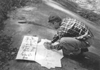
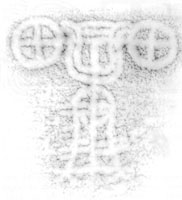
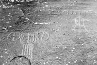 Some of the carvings and surface eroison |
The carvings
as known prior to our work included about 15 carts, 60 wheels or discs
and many cupmarks. Several of the carts have a pair of draught animals,
probably horses. Others have no animals recorded. After five days of
work cleaning the rock of mud, leaves and other debris, drying it, experimenting
with various ways of recording by paper and carbon sheet rubbing, we
managed to identify and record over 20 very faint 'new' images. These
consist of two pairs of (previously invisible) animals attached to already-known
carts, a number of discs or wheels, cupmarks and an unfinished cart
design. |
|
The rock surface at Frännarp may still retain some traces of carvings that we cannot now detect. Some degradation has probably occurred in the past decades and it may be that only very sophisticated high-tech methods will be able to pick up the faintest of images now. Meantime our basic archaeological work has managed to record enough new information to warrant a full publication of the site and work proceeds towards this. Funding for the 2001 study was provided by the British Academy. I am also grateful to the small team who helped in the work and to Lars Larsson for negotiating access to the site and its immediate surrounds. John Coles |
 Some of the carvings and surface eroison |
|
These
amazingly warm Autumn days must be providing some much-needed opportunities
for fieldwork denied earlier in the year due to the outbreak of Foot
and Mouth. I have yearned to be out there myself whilst at the same
time thoroughly enjoying my first chance to edit PAST. Linda has been
busy carrying out a Teaching Quality Assessment in wait for it my
own Department! Life can be ironic! Gill Swanton
|
|
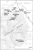
The Archaeological
Investigation team from the York office of English Heritage is half
way through a three year field project which will provide detailed survey
and analysis of twelve hillforts in the Cheviot Hills. This partnership
with the Northumberland National Park Authority forms part of the Park's
long term project 'Discovering our Hillfort Heritage' which aims to
increase the understanding of these monuments as the basis for addressing
conservation, management and access issues. So far the team have investigated
seven sites, ranging from the well-known hillfort at Yeavering Bell,
which at 5.6 ha is the largest in the region, to comparatively small
and obscure sites such as Fawcett Shank, less than 8 km away to the
west, which has never previously been planned or analysed in any detail.
Through a process of accurate survey and careful analysis in the field,
the English Heritage team is already achieving a new level of insight
into the evolution and architecture of the settlements and enclosures
which dominate the hilltops of the Cheviots, as well as examining their
impact on the development of the surrounding landscapes. |
|
|
None of the hillforts
so far surveyed have widespread or incontrovertible evidence of a contemporary
Iron Age landscape surrounding them despite, the fact that at West Hill
and to a lesser extent at Alnham, the surveys encompassed a wide area
around each site. Possible prehistoric cultivation terraces and boundaries
at West Hill may be as early as the Bronze Age and probably continued
in use during the Iron Age. At Alnham prehistoric features surviving
as earthworks are largely absent from the surrounding landscape but
a small Romano-British settlement of enclosed and unenclosed round houses
spreads away from the hillfort. Several terraced trackways probably
served as drove roads bringing livestock to and from the large compounds
within the fort itself. |
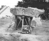
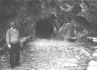
 Differential GPS reading being taken at Kerguerhan |
| Full
interpretative reports, including surveys, analysis, photographs and ground
models are available from the National Monuments Record, Kemble Drive,
Swindon, SN2 2GZ. It is planned to mark the completion of the project
with a book drawing together the results of the research.
For more details contact:
|
|
| SOME
RECENT NEWS ON PALAEOLITHIC ART |
|
| During
the first week of July the national press and the web gave us the first
pictures of the latest discovery of a decorated cave in France. The cave
of Cussac, we are told, was actually discovered last September and contains
some 40 images of engraved animals and symbols. Doubtless, we will learn
more, although full analysis may take some time (below). Nonetheless,
the announcement seems a suitable stimulus to look at some other recent
developments in the study of palaeolithic art in Western Europe.
La Grotte Chauvet, France The debate on Shamanism Pergouset Research and Conservation |
|
|
The use of the
technique is also becoming more widespread. For example, the distribution
of decorated caves in Europe reaches as far south as Andalucia. Although
this art has long been known, it tends to be sidelined by the better
known regions for palaeolithic art, such as Perigord or Cantabria, or
confused with later traditions. Nonetheless, there are some 25 palaeolithic
decorated sites in Andalucia, two of which have recently produced AMS
dates: 20,130 +/- 130 uncal. BP for the depiction of an aurochs at La
Pileta (together with other more recent dates), and 19,900 +/- 210 uncal.
BP for charcoal close to the painting of a stag at Nerja. Stylistically,
these figures have been attributed to the Spanish Solutrean, and the
dates seem to confirm this cultural association (Sanchidrián
et al 2001). |
 Sr José Bullón at |
|
Andrew J Lawson References
|
|
| PROGRESS
AT SILBURY HILL |
|
Most of you will
be aware of the collapse of an eighteenth century mineshaft at the top
of the Neolithic site of Silbury Hill, Wiltshire. This mineshaft was
excavated in 1776 on behalf of the Duke of Northumberland and opened
up again in late May 2000 at the top of the Mound. English Heritage
and National Trust structural engineers designed a robust protective
cover, designed to shed water away from the shaft and to prevent accidents.
This was in place two days after the discovery of the hole.
|
|
These measurements
are statistically consistent and calibrate to cal BC 2490 - 2340 (at
95% confidence), firmly placing the chalk wall at the top of Silbury
Hill in the later Neolithic. It is now clear that a similar "crater"
or crown hole was open during part of the 1920s and 1930s, indeed it
appears that the 1776 shaft has been backfilled (or capped), opened
up again, backfilled and opened up once more for much of its existence.
Structural engineers have indicated that the stability of the monument
is less certain than it had appeared, and a seismic survey was then
commissioned to identify any voids within the hill in order to inform
a repair programme. |
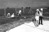 The current editor testing the polysytrene packing. To the left the installation of the framework for the drilling rig. |
| The seismic survey
technique, known as 3D Tomography, produces three-dimensional images through
the ground, and can identify structures and major features such as voids
and cavities. The seismic data is recorded and is being processed using
state-of- the art computer technology in the USA as I write. The first
results are expected in early November, and it is planned to make the
3D images available to the public in future. Once English Heritage has
this information, we will be in a position to assess the problem and take
forward a repair programme. Further details on the repair of Silbury Hill are available on the English Heritage website www.english-heritage.org.uk and will be updated as the project progresses. As usual, for health and safety reasons, there is no public access to Silbury Hill although the monument can viewed from the car park off the A4. English Heritage plans to publish a new monograph on Silbury Hill once the repair programme is finished which will include all the results of recent work. Amanda Chadburn
|
|
Irish archaeology
is becoming increasingly easier to track down on the web with university
departments, research institutions and archaeological companies all
making an effort to make their information widely available. It might
be said that only a few of these sites are particularly innovative,
while only one or two make any use of the interactive capacities of
the medium but they do all provide useful information. Aidan O'Sullivan
|
| ALL
PARTY PARLIAMENTARY ARCHAEOLOGY GROUP (APPAG) |
|
This Group was set up in July 2001 and is asking all organisations and individuals who have an interest in archaeology to submit comments on the current state of archaeology in the UK. "Areas of concern may include legislation, organisational matters and issues relating to culture, tourism, the environment and economy". Points raised should not exceed 250 words and should be sent to james@parliament.uk (preferred option) or sent to Lord Redesdale, Secretary, House of Lords, London SW1A OPW. The deadlines are Nov 30th 2001 for individuals and January 15th 2002 for groups. More information on the Group, which is chaired by Lord Renfrew of Kaimsthorn, can be found at www.sal.org.uk. The Society's Council debated the matter at its recent meeting and will be making a submission.
|
| SOCIETY
BITS AND PIECES... |
||
|
Proceedings Volume 67, 2001 Julie Gardiner, Editor BACK NUMBERS OF THE PROCEEDINGS MERCHANDISE APPEAL
|
| |
The Prehistoric Society Home Page |