|
|
|||||||||||||
|
News in Pictures Europa Lecture Baguley Award New President Editorial New Name for The Society? Find PAST On-Line! Recent Excavation in North Cumbria Carlisle Airport Scotby Road, Durranhill, Carlisle Botcherby Nurseries, Carlisle The 'Grahame Clark and World Prehistory' Day at The British Academy The Sorcerer and the Musical Bow Encore Le 'Petit Sorcier' The Society's Visit to Stonehenge, 19th April 1998 31st International Symposium on Archaeometry, Budapest, Hungary, 27 April - 1 May 1998 On-Line Excavations in Neolithic Orkney Petroglyphs in Southern Kazakstan Champion's Choice Conferences and Meetings
|
|||||||||||||
|
A
NEOLITHIC CAUSEWAYED ENCLOSURE IN KENT
|
|||||||||||||
|
Between April and July 1997 Canterbury Archaeological Trust was contracted by Kent County Council to undertake evaluation trenching ahead of construction works along the route of the proposed Ramsgate Harbour Approach Road. The evaluation revealed the presence of prehistoric activity scattered over a large area. An early neolithic ditch was located within one trench and a crouched burial within another. Other trenches revealed ditches and features dating from the early bronze age to the late bronze age/early iron age. |
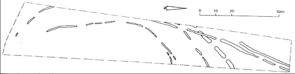 Ramsgate: area of neolithic activity |
||||||||||||
|
Excavations began in November 1997, and initially were concentrated in the area of the early bronze age-early iron age features. An early bronze age round barrow with a single crouched inhumation (accompanied by a beaker and a shale object) was discovered. Other ditches formed part of a late bronze age/early iron age enclosure and field system.
Recent excavations between April and June this year turned towards the area of the neolithic ditch. Excavations revealed the presence of three roughly concentric interrupted ditches - the first verified evidence for a causewayed enclosure in Kent. The two inner ditches were fairly insubstantial. Evidence of episodes of recutting was observed in both, and localised deposits consisting of early neolithic pottery associated with cremated bone, and in one instance a leaf-shaped arrowhead, were present. The outer concentric ditch was considerably wider and deeper than the inner ditches and excavation clearly demonstrated that this ditch was formed by the cutting of a series of pits. Extensive recutting was apparent. Cultural material from some of the deposits contained significant quantities of animal bone including two cattle skulls both recovered from one pit. Other deposits of animal bone and marine shellfish, generally found in association with sherds of pottery, were also present. Additionally the partial remains of two human skulls were recovered from one pit. The primary pits which formed the ditch contained debitage from several episodes of in situ flint knapping. In addition to the three concentric ditches, two outer ditches were also located. These appear to arc out in a broader circuit, but are also interrupted and have evidence of recutting. Further small-scale fieldwork is yet to take place, and it is hoped that the southern part of the most significant ditch will be located. It is anticipated that the post-excavation programme will get underway in the near future and that the results of the excavation will place Kent firmly on the neolithic map.
Grant Shand
|
|||||||||||||
|
|
|||||||||||||
|
Professor George Eogan was awarded this year's Europa Prize and gave the Europa lecture entitled Megalithic Art and Society, after the Annual General Meeting on 20 May.
|
 Molly Clark with George Eogan after presenting him with the Europa Prize | ||||||||||||
|
The Baguley award for the best paper in the 1997 Proceedings went to R.A Housley, C.S. Gamble, M Street and P Pettitt for their paper 'Radiocarbon evidence for the lateglacial human recolonisation of northern Europe'.
|
 Clive Gamble and Rupert Housley being congratulated on the Baguley award by the President | ||||||||||||
|
Professor Paul Mellars was elected President of the Society at the Annual General Meeting
|
 Presidents old and new: Paul Mellars and Tim Champion at the wine reception after the Europa Lecture
| ||||||||||||
|
|
|||||||||||||
| I am delighted to have received responses, published
in this issue, to the article about the 'petit sorcier' interpretation
in PAST 28, and look forward
to more contributions to this debate. The curious find of 10 rectangular unburnt clay blocks, in the bottom of a pit containing burnt material, at Scotby Road, Carlisle (see below) may also occasion some comment; I look forward to hearing from anyone who can enlighten us with parallels or possible interpretations. Please note the insert with this issue of PAST regarding Deeds of Covenant to the Society. You need to read and act on this if you already covenant your subscription, and I would like to encourage more members to consider doing the same: it brings much-needed extra income to the Society, and costs you no more than a stamp. With the summer field and/or holiday season upon us, can I remind you that I would be pleased to have short, preferably illustrated, pieces about new or current prehistoric fieldwork, as well as reviews of exhibitions or 'attractions', for the next issue of PAST. For example, anyone travelling between Aberdeen and Inverness in search of sunshine might like to call in at the Archaeolink Prehistory Park at Oyne and send us a report (details of location, and what to expect, can be found at
| |||||||||||||
|
|
|||||||||||||
|
Clive Gamble sends us news from a source at the Australian National University that "the words prehistoric and prehistory have been struck from the lexicons of the editors of Australian Archaeology and also by Matthew Spriggs from course titles. The former have substituted, respectively, Indigenous (capitalised) and Indigenality(ies). In the latter we now have European Prehistory replaced by the Archaeology of Pre-Roman Europe". Clive wonders whether we shall soon see the Proceedings of the Indigenous Indigenality Society. Your Editor wonders how Irish or Scandinavian archaeologists, among others, would react to their prehistory being classed as Pre-Roman; she has a pretty good idea!
|
|||||||||||||
|
|
|||||||||||||
|
The Prehistoric Society's pages will be on-line shortly. Andrew Garner has designed an eye-catching set of Web pages which include details of the Society (with a form for joining) and its forthcoming events, an index to volumes of the Proceedings, and issues of PAST with the 'Champion's Choice' URLs all hot-linked for direct access. The URL for The Prehistoric Society is expected to be:
|
|||||||||||||
|
RECENT
EXCAVATION IN NORTH CUMBRIA
|
|||||||||||||
|
Cumbria has never figured very prominently in the literature on the prehistory of these islands. Leaving aside the Langdale axe factories, and a small number of major monuments such as the Castlerigg stone circle or the Mayburgh henge, and the work of Jim and Peter Cherry and Clive Bonsall, focusing mainly on the mesolithic, it is difficult to say what was going on in England's second largest county before the Romans arrived. A combination of factors have mitigated against casual discovery, whilst the absence of a university with a strong interest in prehistory has not helped when it comes to formulating research projects.
|
|||||||||||||
|
This note takes the story a bit further by describing some of the salient features from three other CAU projects in two areas. In each case the potential of the site was established by evaluation which was followed up by excavation. Furthermore, nearly all the features identified would have been undetectable both from the air and by geophysical means. In such circumstances, the only way of locating sites with shallow and narrow cut-features on the heavily glaciated soils of north Cumbria is by the spade. First, Paul Flynn comments on work at Carlisle Airport, only a short distance to the NE of the site at High Crosby. Then Kate Hirst and Richard Barkle outline results of work in the eastern suburbs of Carlisle in the valley of the Durranhill Beck, where settlement, burials (a chance 19th century discovery at Garlands Hospital), a possible 'ritual' monument and a burnt mound are attested for the bronze and iron ages.
|
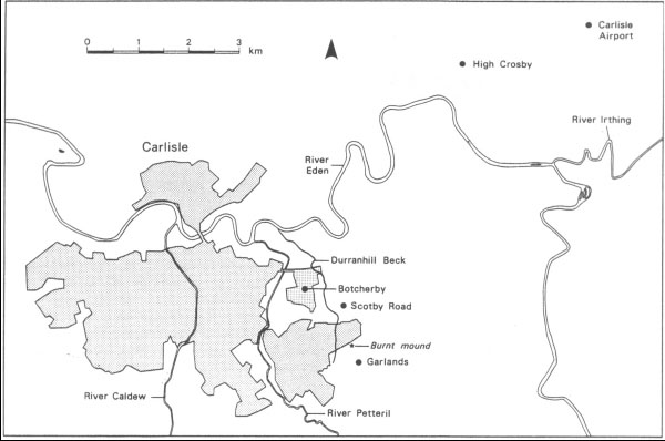 Location map of sites in North Cumbria
|
||||||||||||
|
|
|||||||||||||
|
The site is located 8 km NE of Carlisle on a gentle west-facing slope
at a height of about 45m OD, on soils of the Clifton Association, and
1.3km N of the confluence of the Rivers Eden and Irthing. Some 2.5 km
to the SW is the neolithic and bronze age site at High Crosby (Flynn
and McCarthy 1994). Another site, also of prehistoric date, was found
near High Crosby. All three sites are in broadly similar locations on
well-drained sandy ridges only a short distance N of the River Eden. |
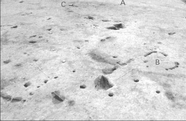 Carlisle Airport: view from E, showing the eroded hollow (A-A) and the D-shaped structure (B), with one of the large stones of the alignment (C) removed from its modern pit. Scales are 2m. | ||||||||||||
|
Enigmatic traces of 'ritual' activity may be represented by a number of
large stones. Two had been buried in pits in recent times, presumably
close to their original positions. The largest measured 1.1m x 0.6m x
0.4m, but as both ends had been broken off it had clearly once been longer.
These stones were 14m apart, and a third set in a shallow pit lay some
12m away, suggesting a slightly curved alignment. Two other stones, not
following the same alignment, appeared to be in situ. They were carefully
laid in pits, with their flat upper surfaces protruding only 0.lm above
the natural subsoil, and packed in with stones and redeposited subsoil.
The only chronological indicators so far are a single radiocarbon determination in the 4th millennium BC suggesting an early neolithic date (4645±60 BP uncalibrated; OxA 6180), and three sherds of decorated pottery thought to be of late neolithic or early bronze age date. Paul Flynn
|
|||||||||||||
|
Scotby Road, Durranhill, Carlisle
|
|||||||||||||
|
In 1998 Carlisle Archaeological Unit undertook excavations on a small hilltop adjacent to Scotby Road, on the eastern side of Durranhill Beck, within view of Botcherby Nurseries (see below). About 1.3km to the S, close to the source of the Durranhill Beck, is Garlands Hospital, where in 1861 building activity revealed 15 early bronze age collared urns with burials and many fragments of other vessels including pigmy urns and a beaker (Hodgson 1956, 6-12). In 1997, following initial work by Lancaster University Archaeology Unit, excavation at Garlands Hospital by the Centre for Field Archaeology, Edinburgh, revealed a burnt mound (Neighbour 1997). No dating for this is available yet, but it is thought likely to be bronze age. |
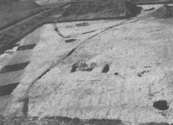 Scotby Road, Carlisle: two palisade slots, a ditch (left) and pits | ||||||||||||
|
At Scotby Road some 51 trenches were excavated, exposing a large number of features cut into a varied natural subsoil of gravels, sand and silty clay patches. The earliest phase comprised a palisade slot located on the NE side of the hill crest, narrow in the N and broad in the S, measuring 41m from N to S and 32m from E to W and enclosing a roughly ovoid area of approximately 205 sq m. Much stone packing material was found in parts of the slot, but no sign of an entrance was located within the excavated areas. The second phase also consisted of a palisaded enclosure. Enclosing some 344 sq m, the palisade defined an irregular square with rounded corners. An entrance 2.2m wide was defined by two postholes set into the ends of the palisade slot. The third phase, a ditch thought to be either a field boundary or part of another enclosure, is attributed to the Roman period on the basis of pottery and a quern found in the fill. Although no features can be directly associated with the first phase of palisaded enclosure, numerous postholes, pits and gullies were located within the enclosed area, the majority of which were around the edges of the palisade, with none in the centre. One pit was of particular interest as it contained a large quantity of redeposited burnt material, including burnt bone and prehistoric pottery. Near the base of the pit was a collection of 10 rectangular unburntclay blocks, below which was another deposit of burnt material. Several theories have been advanced to explain the presence of these clay blocks, one of which is that the pit was used for the storage of clay for a potter but this does not explain the presence of the large quantity of burnt material below and above the clay blocks; another possibility is that the blocks were placed there in an activity that could have had ritual connotations involving the cremation of either humans or animals. |
|||||||||||||
|
As with the first phase, no features can be stratigraphically linked with the second phase of palisaded enclosure and so it is impossible to determine its purpose. A number of postholes, pits and gullies were found within the enclosed area, including a line of postholes nearly 8m long, perhaps a fence line, and a series of large pits, one of which had been recut several times and contained a quantity of charcoal in the primary fill. This pit was surrounded by postholes, which may have supported a structure that covered or surrounded the pit.
The difficulties of deciding which, if any, of the cut features may belong with either of the palisaded enclosures are compounded by the proliferation of postholes and other burnt areas, some associated with charcoal and fire-cracked stones, outside both enclosures, although detailed post-excavation analysis and radiocarbon determinations may help to clarify the picture. Over 40 sherds of prehistoric pottery have been recovered, and although it has yet to be positively identified, at least two types can be recognised: sherds resembling food vessels or collared urns, and fabrics strongly reminiscent of iron age wares found in NE England. Kate Hirst |
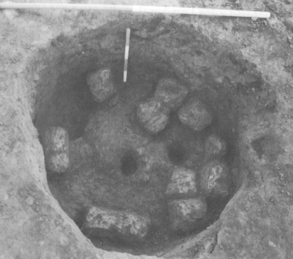 Scotby Road, Carlisle: a pit with a deposit of 10 clay blocks | ||||||||||||
|
|
|||||||||||||
|
Botcherby Nurseries is situated on a hilltop 2.2km east of Carlisle city centre. It overlooks the confluence of the Rivers Eden and Petteril to the W, and the minor Durranhill Beck to the E. Although the courses of these rivers have undoubtedly changed in the past, it seems likely that the hilltop would have been surrounded on at least three sides by rivers and streams in the prehistoric and early historic periods. Botcherby hilltop is within sight of at least two other major prehistoric sites, at Scotby Road approximately 800m to the E (See above), and at Garlands Hospital some 1.9km to the SE.
|
|||||||||||||
|
THE
'GRAHAME CLARK AND WORLD PREHISTORY' DAY AT THE BRITISH ACADEMY
|
|||||||||||||
|
|
|||||||||||||
|
THE
SORCERER AND THE MUSICAL BOW
|
|||||||||||||
|
| |||||||||||||
|
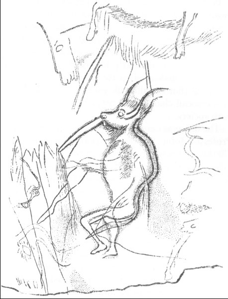
We may, for example, look first at the bow, here illustrated by Breuil and described by Demouche et al as consisting of two lines, one straight, one curved. This motif is considered in isolation, although in fact it abuts on a series of parallel lines, ending in points, to which it appears to relate in that the base of the 'bow' is drawn up to, or from, one of these uprights (Geidion 1962 publishes a photograph of this, fig. 338). In addition, the two 'bow' lines are augmented by a third, curved, joining the lower of these (see Bahn & Vertut's photograph, 1988 fig. 104). All these lines are more clearly cut than many of the animal figures on the wall (including the 'petit sorcier') and should be taken into account rather than omitted in favour of a selected reconstruction. Whether you should, or should not, consider the 'sorcier' in isolation from other figures on the sanctuary wall is another matter. |
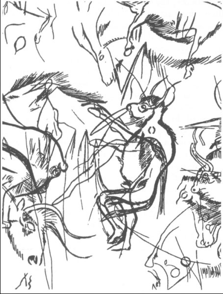 Breuil's original transcription of the 'petit sorcier ŕ l'arc musical' (1952 fig.20) | ||||||||||||
|
Secondly, the 'petit sorcier's' upper arm, which Breuil drew across the 'bow' and which is disguised, as is the lower, as an animal leg, is not verifiable in a photograph. Geidion's transcription (1988 fig. 338) places two arms, tentatively, in the lower position, where Breuil drew one, but whether single or a pair, these 'arms' are far from clear. In the context of this cave it is unusual for a limb to cross the continuous outline of a body; here figures are characteristically engraved with an unbroken outline. The fact that the 'arms' of the 'petit sorcier' are animal legs, that they truncate the man/bison's stomach, and that there are so many additional figures on the wall, suggests that they may possibly relate to another animal figure, cut beneath or superimposed on the man/bison. |
 Geidon's transcription of the same composite man/bison (1962 fig. 338) | ||||||||||||
|
Discounting those attributes that are questionable, we are left with a bison's head, pelt and tail mounted upon an apparently human figure confirmed (though only in Breuil's transcription) by a human phallus and with human feet. The position of the feet suggests a human standing, in that they are placed at an angle that is unlikely, though not impossible, for anyone crawling. The arms that such a personage would need to go on hands and knees are not necessarily a part of this figure, while the tail, which Demouche et al maintain is more correct for a figure viewed horizontally, since it follows the line of the thigh, is not an absolute guide. The picture they themselves illustrate in their paper of a Lakota hunter has a tail that hangs down when the figure is viewed (incorrectly) as vertical, but trails behind when the figure is, correctly, seen on hands and knees. The description of the lines drawn from the bison's mouth as bow or flute, is equally speculative. Bahn & Vertut (1988 p. 158) suggest that these lines could represent the nose-bleeds often experienced by shamans entering a trance, an explanation less fanciful, in their opinion, than a figure playing a musical bow. The tip of this arc, or 'bow', or geometric motif, is cut around the bison's nostril, so one probably cannot dismiss it as unrelated, but both nostril and 'bow' tip outline a natural small pit in the rock. On one occasion this may have been incorporated in a geometric design, on another in a bison's head; they may relate to one another and have been engraved simultaneously, or have been cut on different occasions. One may speculate endlessly, but at this point we need to re-examine Breuil's interpretation. As Léon Pales insisted (Pales & Tassin de Saint-Pereuse 1965) photographs are a test of authenticity and must be used, not least because they may be enlarged. If the petit sorcier' is re-examined, we may find that Breuil's transcription is indeed correct but, for the moment, we should not build upon it.
| |||||||||||||
|
ENCORE
LE 'PETIT SORCIER'
|
|||||||||||||
|
Though admirable in its attention to problems of perception of parietal images, the approach of the three students of the Aix-en-Provence Laboratoire is not new. They analyse the sorcerer in the panel in Les Trois Frčres which the Abbé Henri Breuil describes as "In the Sanctuary. Right part of the horizontal corridor leading to the cross road with the small Reindeer". Undoubtedly correct visually, their conclusions have been arrived at before, by Max Begouën and, after talking to him, corroborated by myself among others.
As Breuil drew the panel, it is extremely busy. From the two all too brief periods during which I have been able to study it on site, I am certain of only one thing. It cannot be seen as the Abbé Breuil drew it and never could. His method of making an enlčvement results in the assumption by others, if not by him, that the images of animals are projected onto a planar surface as the figures in a post-Renaissance canvas are projected. They are not. The shape of the floor, in so far as it determines places where a viewer can stand, together with the undulations of the surfaces supporting the engravings, determine what can be seen, not the linear proximity of the outlines across the rock. Max Begouën admired the Abbé Breuil's industry, pointing out in the 'Tréfond' the rusting remains of the metal chair he used when working in the cave. He also pointed out that the Abbé Breuil was profoundly concerned with the impact upon perception of the volumes and voids comprising the image-supporting surface. This is not only confirmed by others who were fortunate enough to enter an image cave with Breuil, but also by the photographs in the publication on Font de Gaume, taken from three different viewpoints, of the bison in the terminal cleft. I cannot now recall whether Max Begouën actually demonstrated the figure of a man with a bison head and a bow as best seen from a point of view which makes it look as if it is on hands and knees, or whether his remarks merely suggested it to me. I am certain, however, that Demouche, Slimak and Deflandre, had they had the opportunity of discussing the matter with him, would have received his enthusiastic agreement. I recall that when I saw the figure with the bow, I concluded that Max Begouën's suggestion of its close comparability with the large painted and engraved 'Sorcerer' high up on the wall of the 'Sanctuary' was valid. He certainly demonstrated when we were in the cave together and, if I remember rightly, said in the book he published in English, The Clay Bison (1927), that crawling up the small side tunnel to get into a position close to the large 'Sorcerer' from which could be drawn, resulted in that figure appearing as if on hands and knees. It is only from the slope of the calcite cascade down which one descends into the 'Sanctuary' that the antlered figure appears as if to stand in a crouching, shambling run. In retrospect I wonder whether Michel Lorblanchet's assessment published in Animals into Art (Morphy 1989) of intentional ambiguity in many of the figures in Pech Merle also applies to salient figures in Les Trois Frčres. Unlike external image sites surrounded by growing vegetation, caves like Les Trois Frčres make it relatively difficult to decide upon the viewpoint from which an image should be seen. If there were ever the kinds of orientation marks in the cave which establish verticals and horizontals and stabilise the images in the 'Apse' in Lascaux - they show in Glory's tracings in Lascaux Inconnu (1979) - or across the ceiling of the 'Sanctuary' in La Pileta (just visible in Breuil's photographs in Four Hundred Centuries of Cave Art), then they have never been remarked on. They may have disappeared when the film of red cave earth through which the engravings were incised flaked away. It was still visible in places in the 60s but had gone by the 70s, and Max Begouën was bemoaning its loss despite the care that he and his two brothers had taken of the cave since they had first entered it 50 years earlier. Orientation marks of some kind are a fundamental perceptual requirement of picturemaking. Framing is a method which has been employed in the tradition of western European art from Predynastic Egypt to the present day, but with complicated viewpoints such as in Michelangelo's Sistine Ceiling or a Bonnard domestic interior, they also have to be incorporated into the painted surface. It may well be that orientation marks were not needed in Les Trois Frčres. There were none in either Ekain or in the Camarin at Gargas, and both are fairly profusely covered with images. Instead, there are locations at which a light can be conveniently placed, so that the shadows cast combine with the spaces on the cave floor on which it is convenient to stand, to establish the way in which a particular image should be viewed.
| |||||||||||||
|
THE
SOCIETY'S VISIT TO STONEHENGE, 19TH APRIL 1998
|
|||||||||||||
|
The Society's visit to Stonehenge started in the early the afternoon of a cold and very wet Sunday (April showers?). However; twenty or so members of the society braved the elements in order to make the most of the opportunity to explore Britain's most of photographed heritage site in the company of English Heritage's Chief Archaeologist, Dr. Geoffrey Wainwright and the Director of Wessex Archaeology, Andrew Lawson. The tour began with a walk along The Avenue towards King Barrow Down, the party of anoraks stopping occasionally for some enlightening words from our guides (was it just our imagination or did it rain harder when we stopped?).
From King Barrow Down we then walked the length of the Cursus, pausing to appreciate Stonehenge on the horizon, before stopping at the Fargo plantation to view the proposed site for the new visitor centre. Gingerly passing the herd of slightly threatening cattle, and against a strong the headwind, we made our way back past the Cursus Barrows. We marched on to the Car Park, spurred on by the knowledge that tea was available (and that the toilets possessed hot-air hand-dryers!). Once the visitor's centre was closed, and after the group was sufficiently revived, we were taken into the 'Stones' themselves. Unlike most of the party, this was my first trip to Stonehenge and, especially after learning about and walking around the surrounding monuments, the Stones close up really brought home the magnitude of the builders' achievements. The scale of the site and its enduring importance to prehistoric people is really quite staggering. Thanks must go to our guides, and to the other members of the group, for their perseverance against the elements and for making the day both informative and enjoyable. Finally a thought must be spared for the security guards who, as we left - soaked to the skin - with the rain still coming down, told us that they would be on duty until two o'clock in the morning!
|
|||||||||||||
|
31ST
INTERNATIONAL SYMPOSIUM ON ARCHAEOMETRY BUDAPEST, HUNGARY, 27 APRIL
- 1 MAY 1998
|
|||||||||||||
|
The International Symposium on Archaeometry takes place bi-annually, and this year was held at the Hungarian Academy of Sciences in Budapest. The symposium attracted over 250 participants from around the world and from all branches of archaeometry (archaeological sciences).
The conference ran over five days and covered a number of themes ranging from archaeological biomaterials to field archaeology, and provenance of pottery to dating. A particularly interesting session covered experimental archaeology, and several researchers recounted their experiences of trying to recreate past technologies. The conference delegates ranged from students to well-established academics, and there were a number of well-known researchers in my field with whom it was very useful to discuss my ideas. I also found it useful to exchange experiences with other students at similar stages in their careers. I gave a poster presentation on one of the more unusual aspects of my work, 'Characterisation of Mesolithic Chewing Gums'. The poster aroused a great deal of interest and generated some useful discussions. At the end of the conference prizes were awarded for the best posters, and I received two awards in two separate competitions. One was the Martin Aitken award for the best student poster, and the other was second prize in a general competition for all the posters in my session (of which there were 116). In addition to being a useful experience from an academic point of view, the conference was also very enjoyable. The Hungarian organisers had put a great deal of effort into making the conference a memorable one, and they had arranged a number of events for us including an excursion to the Roman city of Acquincum, and a cruise with banquet on the river Danube. I would like to thank The Prehistoric Society for making attendance at this conference possible for me.
|
|||||||||||||
|
ON-LINE EXCAVATIONS IN NEOLITHIC ORKNEY
|
|||||||||||||
|
Just as we went to press, news came that the excavators of the Crantit tomb in Orkney, were running an on-line excavation diary. A visit to the 'site' showed the power of the Internet to deliver to a world-wide audience details of a project as it develops, an a day-by-day basis, with text and colour images.
The apparently undisturbed tomb was discovered in May when a tractor broke through to the chamber while ploughing. The site is being excavated by Glasgow University, and is being recorded by the BBC's 'Meet the Ancestors' team. With their assistance a small digital camera was lowered into the undisturbed tomb, allowing pictures to be taken of the internal structure and of piles of human bones. In the hope that the floor of the chamber would be undisturbed, allowing investigation of detailed burial practices and of potential foot and other prints, the excavation team includes a Scenes of Crime Officer from Strathclyde Police. The first entry to the site journal is dated 16 July; by 18 July there were already 10 pages of text and/or images. Colin Richards says: "Over the coming weeks these pages will be written by different people who undoubtedly will have different views of what is occurring! This will provide an insight into the process of archaeological interpretation, which is far from straightforward or unitary." One entry describes the excavation, on the Island of Eday by the Sheffield University team, of another unexpected neolithic tomb. News of worked flints and stone tools followed, with more details promised for 20 July: proof-day for this issue of PAST! Keep abreast with Orcadian neolithic news at
|
|||||||||||||
|
PETROGLYPHS
IN SOUTHERN KAZAKSTAN
|
|||||||||||||
|
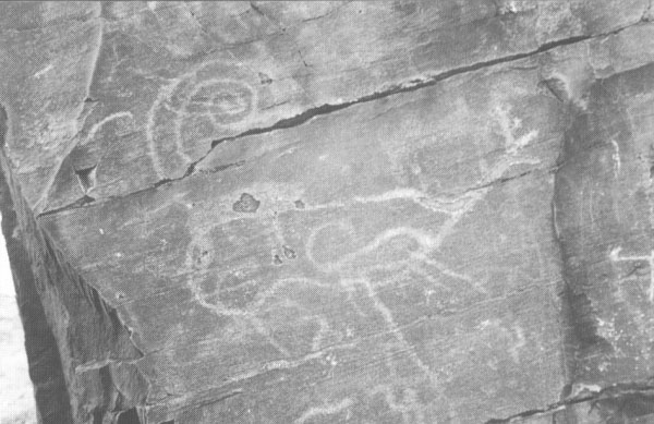
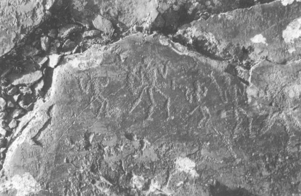
In April this year I had the pleasure of participating in the joint Kazaki-Polish survey of the Aprauzen petroglyphs in the mountains of southern Kazakstan. Aprauzen is the local name for an area on the eastern side of the Karatau mountain range which consists of foothills and plateaux near the village of Abai. Aprauzen has one of several concentrations of petroglyphs in the Karatau mountains, previously documented in a book by Kadyrbaev and Mar'yaslev (1977). The 1998 expedition was directed by A. Roswadowski of the Institute of Prehistory at the Adam Mickiewicz University in Poznan, Poland and Z. Samashev of the A. H. Margulan Archaeological Institute, Almaty, Kazakstan. The objectives of the expedition were to reconfirm the accuracy of these previously documented recordings, to examine their state of preservation, and to collect data for doctoral research.
|
 A complex scene with a large stag believed to be from the Sako-Scythian period |
||||||||||||
|
Our first field season was very successful: most of the published scenes were re-identified. The petroglyphs were carved into the exposed shale bedrock within the ridges and valleys of the Aprauzen foothills. They contained imagery which is typical of central Asian sites: there were depictions of bulls, deer, goats, horses, camels, chariots and human figures. There were scenes of 'warriors', chariots and bulls which are believed to belong to the bronze age, and large depictions of stags which are considered to have been carved during Scythian times by the Saks. These people occupied the territory of Kazakstan during the early iron age and had affiliations with the greater Scytho-Siberian culture of the Eurasian steppes.
New accurate recordings were made of the images using two methods: the first, by rubbing onto tissue paper which was moulded onto the rock surface by the application of water, the second by tracing onto clear sheets of polyethylene plastic. In addition to the published scenes, several new scenes were discovered. These included a few scenes associated with concentrations of dots, and an intriguing scene with a goat and a dog superimposed on a large grid. The most exciting finds were the discoveries of two new scenes of 'Scythian' animals, one featuring a large stag and the other a large stylised carnivorous beast. |
|||||||||||||
|
Some rock surfaces bearing petroglyphs were found to be fragmented by natural processes such as freeze-thaw of the rock, and some of the scenes had to be re-assembled like a jigsaw puzzle from the dispersed fragments. But the greatest threat to the petroglyphs is vandalism by local people. Graffiti of Kazaki names can be found cut into petroglyph images and during our study period two village boys covered one scene with blue paint, running off down the valley before we could stop them. The scene was not damaged, but now sports a coating of permanent blue paint which will take years to weather away.
|
 A scene with human figures believed to date to the bronze age |
||||||||||||
|
The dating of the petroglyphs in Aprauzen is still far from being secure. Current estimates of date are based on the style of the technical rendition of the petroglyphic elements and their image content. Such speculations are far from conclusive, and alternative dating techniques will he considered in future investigations.
The results of this preliminary exploration of the Aprauzen area have been very encouraging, and a full-scale survey is scheduled for next year. The data collected is currently being used as part of ongoing doctoral research; an initial article about one of the Aprauzen scenes will be included in the forthcoming Festschrift for Z. Samashev due to be published in Moscow in 1999.
| |||||||||||||
|
CHAMPION'S
CHOICE
|
|||||||||||||
|
Çatalhöyük: Excavations of a Neolithic Anatolian Tell: This
site "is designed for those interested in the ongoing excavations at
Çatalhöyük", and offers illustrated newsletters about project results,
bibliographies, archive reports, artefact distribution plots, access
to part of the excavation database, and QuickTime Movies of the excavation
and the reconstructions. An excellent use of the WWW to disseminate
detailed information about an ongoing project.
|
|||||||||||||
|
|
|||||||||||||
|
Recent developments in wetland research: 26.8.98-29.8.98
|
|||||||||||||


 |
The Prehistoric Society Home Page |