| Homepage | Timeline | Maps | A-Z index | Learning |
Settlements, Towns and Cities in Egypt
In comparison to other parts of the world, relatively little research had been devoted to settlements in Egypt until recent years. Many expeditions concentrated instead on monumental architecture and formal art - on temples and tombs, which are richest in high quality art objects. Settlements do not offer the same attraction. Nevertheless there has been an interest in town planning from the early days of European exploration: for example, the French military expedition of 1798-1801 recorded the street plan of Amarna (then undated) and the Roman ruins at Antinoe (since that time partly destroyed). Flinders Petrie worked at settlement sites of all periods, but before the refinement of archaeological methods to tackle the problems of settlement excavations. In recent decades more modern techniques have enabled much more accurate recording of sites, and it seems clearer now that the persistent view of Ancient Egypt as a 'civilization without cities' (Wilson 1958) is inaccurate (see already Kemp 1972).
The earliest settlements seem to have been in general quite irregular; no planning is visible, and the clusters of houses seem to have grown 'organically' without any non-environmental factors of control. One important environmental factor in the Nile Valley is the prevailing north wind, making the northern end of a site the more desirable, upwind of any workshops or kitchens: already at the South Town at Naqada, the effect of this can be seen in the location of the palatial establishments (?) at the north.
|
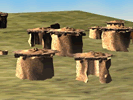
Hemamieh, about 4000-3500 BC
|
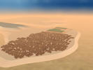
Naqada, about 3500 - 3000 BC
|
 |
 |
In the First Dynasty and early Old Kingdom (about 2686-2181 BC) many towns were enclosed by a wall. The layouts of the few town walls found constitute the earliest evidence for intervention or planning, at the level of framing the settlement site. The few buildings remains found and excavated inside of these enclosures show that there was no street grid to organise the internal settlement space. For the remainder of the Old Kingdom there are no excavated town sites to follow developments in planning, a solitary exception being the 'organic' settlement at Elephantine, perhaps atypical.
|
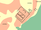
Hierakonpolis, about 3000 BC
|
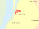
Abydos, about 3000-600 BC
|
Buhen, about 2500 - 2300 BC
|
 |
 |
 |
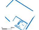
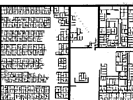
The Middle Kingdom (about 2025-1700 BC) seems to have been the highpoint for centralised planning of new towns, typically within rectilinear boundary walls, and on a strict orthogonal plan - a street grid as regular as a Roman military camp or a modern New World city. Although 'organic' towns must have continued to thrive, as at Elephantine, gridded 'new towns' are attested across the country. The largest of these settlements to survive is Lahun, the pyramid town of Senusret II: its plan was recovered by clearance of the site by Petrie in 1889. Other similar settlements have been excavated at Abydos and at Abu Ghalib in the Western Delta, and Tell el-Daba in the Eastern Delta.
|
Lahun, about 1800 - 1700 BC
|
 |
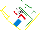
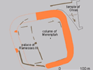
Several New Kingdom (about 1550-1069 BC) settlements and towns have been excavated. The largest and most famous example is Amarna, the capital of Akhenaten. The plan for most of the city is relatively well preserved, giving a fair idea of a royal Residence city of the period. Other partly excavated cities include Gurob and Tell el Yahudiyeh. At both places very few remains survive today, but enough was recorded by earlier excavators to show that they are the sites of royal palaces. Another palace settlement site of the New Kingdom is at Malqata, on the West Bank at Thebes: this seems to have acted as the centre for celebrations of the jubilees at the end of the reign of king Amenhotep III.
The New Kingdom sites indicate town planning only in terms of the general layout of the cities. Houses of private individuals are often located within the town without following orientation of other buildings.
|
Amarna, about 1400 BC
|
Gurob, about 1450-1350 BC
|
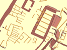
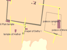
Memphis, about 1350 BC
|
Tell el Yahudiyeh
|
 |
 |
 |
 |
further reading:
|