
The Route
Not all expedition members were present at all the sites and not all the sites were archaeological; they visited markets, a glass factory, interacted with local people, and participated in experimental work.
The team arrived in Afghanistan on July 29th 1968: Kara Murad Beg, Estalif, Bamiyan, Farinjal, Pandshir Valley, Zar Kashan, Mirzaka, Karystu Valley, Askar Kot, Tepe Mudigak, and Herat.
They went on to Iran / Tehran on August 12th: UzbeKuh / Deh Qaleh, Deyhuk, Tepe Yahya, Deh-i- Sard, Saichah, Tal-i-Iblis, Qatru, Kuh-i- Sorgh, Estebanat, Estakhr, Torshab, Persepolis, Zar Tsheshmeh, Pasargadae, Hamashk, Talmessi, Meskani. The names have been taken from Radomir Pleiner’s unpublished data (Pleiner 1968, A11). After Meskani further visits were made to Talmessi, before moving on to Sialk, then Kashan city and finally Ahaer in Iran.
Lastly, they went to Turkey on September 16th, covering: Trabizon, Tirebolu, Ergani-Maden Mine, Geyduk, Kultepe, Catal Hoyuk and Acem Hoyuk (Tylecote, 1968, A3).
 |
|
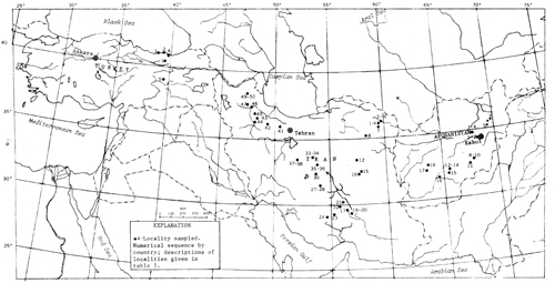
Geological Map of the 1968 Survey. Showing the localities sampled in Afghanistan, Iran, and Turkey. (source: USDIGS report (1978); IoA Source code: D02). Click map to see a larger version |
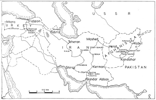 |
Pyrotechnological Map of the Survey 1968. Map showing parts of the Near East visited by the 1968 expedition. (source: Tylecote (1970) Fig. 1; IoA Soure code: E06). Click map to see a larger version |