UCLDH seminar: digital geo-spatial inventories along the Silk Roads of Central Asia
05 February 2020, 6:00 pm–8:00 pm

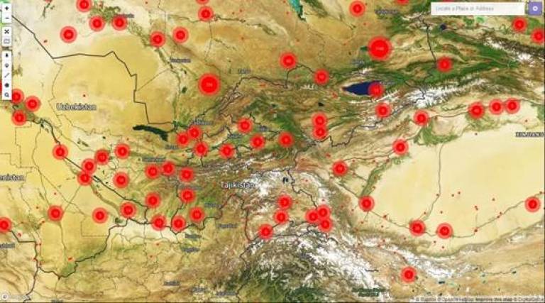
The Central Asia Asian Archaeological Landscape (CAAL) project, based at the UCL Institute of Archaeology, is digitising archaeological heritage across a vast region from the Caspian Sea to western China.
This event is free.
Event Information
Open to
- All
Availability
- Yes
Cost
- Free
Organiser
-
UCLDH
Location
-
G31, ground floorFoster CourtMalet PlaceLONDONWC1E 7JEUnited Kingdom
There is an astounding range of archaeological heritage in Central Asia, but while many of sites are already protected by state legislation, a very significant number are not. This complex record of the adaption of humans to the diverse Central Asian landscapes is under threat from multiple activities: changing agricultural practices (especially in the context of the climate crisis, with changing patterns of irrigation and hydrology as a result of the collapsing glaciers of the ‘third pole’ in the Himalaya-Hindu Kush mountain ranges), infrastructure schemes, urban expansion and rural depopulation. The future of heritage resources depends on strategic planning, as part of sustainable development policies. This requires a solid, and accessible, platform of information for the local agencies to work with. Numerous teams across the region are digitising existing archives and records, and in doing consolidating the information held by regional institutions and research centres, into a single multilingual geo-spatial database, using the open-source QGIS platform. This will be enhanced by new research, using a combination of photographic and satellite imagery, along with targeted field visits, in order to discover new sites, improve documentation, promote awareness and scholarship, and facilitate policy-making.
The project is creating an online digital inventory, adopting the open-source ARCHES inventory package, developed by the Getty Conservation Institute and the World Monuments Fund. The project is a partnership between institutions from the Republic of Kazakhstan, Kyrgyz Republic, Republic of Tajikistan, Turkmenistan, Republic of Uzbekistan, and the People's Republic of China (Xinjiang Uyghur Autonomous Region). It also includes the International Institute for Central Asian Studies, based in Samarkand, and the ICOMOS International Conservation Centre in Xi'an.
The project has been made possible by the generosity of Arcadia – a charitable fund of Lisbet Rausing and Peter Baldwin.
All are welcome and there will be drinks and discussion after the presentations. Attendance is free but we kindly ask that you register for the event.
This event is organised by UCLDH, which is part of the UCL Institute of Advanced Studies.
About the Speakers
Tim Williams, Associate Professor in Silk Roads Archaeology. Tim has a background in urban archaeology. Worked in Department of Urban Archaeology, Museum of London, and then English Heritage, before joining UCL Institute of Archaeology in 2002. Undertaken major projects in Beirut (Lebanon) & Merv (Turkmenistan). Current research is focused on urbanism along the Silk Roads, especially Islamic & Central Asian. Undertook the ICOMOS thematic study of the Silk Roads, and working on the South Asian Silk Roads and Maritime Silk Routes projects. Currently Director of the International Centre for Silk Roads Archaeology & Heritage, and Principal Investigator for the Central Asian Archaeological Landscapes project (CAAL), at the UCL Institute of Archaeology.
Dr Gai Jorayev, Research Fellow. Gai has a background in heritage management. Gai is experienced in spatial analyses and modelling, and he leads research initiatives on uses of Unmanned Aerial Vehicles (UAV) in archaeology. He manages the Digital Heritage Laboratory at the UCL Institute of Archaeology and works on Virtual Reality (VR) and Augmented Reality (AR) applications for public outreach, interpretation and education. Using digital documentation techniques for creating detailed, open-access heritage inventory systems, and for monitoring change over time is some of the key areas of research at present.
Dr Marco Nebbia, Research Fellow. Marco is a landscape archaeologist with a keen interest in GIS and remote sensing and the application of these technologies to the management of cultural heritage. His passion for capacity building stems from a more fundamental research curiosity about prehistoric urbanism and the confluence of the local with the global scale of human interaction. On CAAL he is working with our Central Asian partners in developing robust methodologies and uses of GIS technology in documenting archaeological heritage.
 Close
Close

