 Close
Close

Sponsored by the Greater London Authority and London Connects. Start date: 01/07/2003. End date: 31/12/2009
The model is being standard GIS and CAD techniques but a variety of new photorealistic imaging techniques and photogrammetric methods of data capture are being used to render detailed scenes. Using Ordnance Data Master Map and InfoTerra height data, the entire area within the M25 Orbital Road has been modelled. Currently we are exploring how the model can be ported to external users using ‘free software; such as Google Earth and ArcExplorer, interfaces which are being developed in the related GeoVUE project.
Currently we are piloting a version of the model with various local authorities in London who are licensed for the data but often do not have the software in-house. Google Earth is thus essential for such access but this is part of wider venture for utilising techniques to optimise large urban data sets for broadband distribution.
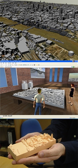
Key to this is communicating the built environment in an innovative manner using Multi-User Environments in which participants will be able to roam around a Virtual Gallery as Avatars (digital representations of themselves) and explore the issues relating to London in game-like space.
Techniques to engage the public in issues relating to their environment have been developed by CASA over the last 10 years and this project is the largest of its kind to openly encourage participation in three dimensions via the Internet. Using these techniques which support all stakeholders in the planning process, the way we participate in shaping our environment is on the verge of being radically opened up.
We have many partners in this project and it is thus impossible to attribute the model to any particular source. Ordnance Survey and InfoTerra provide the data, ESRI have provided the software while various agencies and companies in and out of government such as BT, GLA, London Connects and DCLG have provided various kinds of support. We consider that this variety of funding and supports indicates that Virtual London belongs to all those who wish to use it to improve our quality of life.
People
Michael Batty
View Michael's profile
Andrew Hudson-Smith
View Andrew's profile
Richard Milton
View Richard's profile
Chris Parker
Aidan Slingsby
Duncan Smith
View Duncan's website