 Close
Close

GeoVUE is one of seven nodes in the National Centre for e-Social Science whose mission it is to develop grid and web-based technologies for the social sciences.
The project is strongly linked to two others in CASA – Virtual London and Mapping Pollution – which uses similar techniques of visualization. GeoVUE is developing three demonstrators which draw on the applications in these related projects.
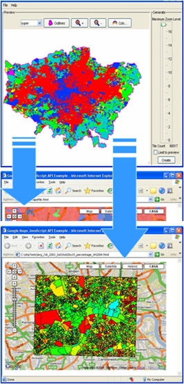
The first demonstrator is to link ‘publicly available’ data sets such as those from the National Population census to non-proprietary mapping and currently we are developing some rudimentary exploratory spatial data analysis using geodemographic data in Google Maps. The mapping hacks that we have developed enable users to take any data in an appropriate mapping file and convert this to form where it can be immediately visualized in a web page. We call this interface MapTube.
The second demonstrator will be focused on linking 2D and 3D map data to real time pollution data. Richard Milton has experience of collecting such data in portable fashion and we hope to link this and data which is routinely monitored by the Air Quality archive to real time GIS. Again we envisage that the interfaces will make use of ‘free technologies' such as Google Maps and Google Earth.
Our last demonstrator will be much more ambitious and this will enable users to fashion their own virtual environment using online tools. We will be starting this later in the project in 2008/9. Currently we are also interfacing with other simulation modelling work in the social sciences that is making use of grid technologies such as the micro-simulation work being developed in the MOSES node at the University of Leeds and the Policy Grid node at Aberdeen where CA models of land cover are being grid-enabled. These links relate to other CASA projects in Agent-Based Modelling and Simulation and we are also linking this work to the Center for Spatially Integrated Social Science (CSISS) at the University of California at Santa Barbara.
People
- Michael Batty
- Andrew Hudson-Smith
- Paul Longley
- Richard Milton
- Anthony Steed