 Close
Close

Latest
209 results

CASA Working Paper 48
CASA Working Paper 48. 1 May 2002. Designing plans: a control based coordination model. In this paper we discuss artificial plan designing as a research field that deals with the development and use of computational models to support the generation…
Centre for Advanced Spatial Analysis

CASA Working Paper 50
CASA Working Paper 50. 1 May 2002. The Impact and Penetration of Location-Based Services. The Ordnance Survey, the National Mapping Agency (NMA) for Great Britain, has recently begun to research the possible extension of its 2-dimensional geographic…
Centre for Advanced Spatial Analysis
CASA Working Paper 49
CASA Working Paper 49. 1 May 2002. Multi-dimensional Modelling for the National Mapping Agency: A Discussion of Initial Ideas, Considerations, and Challenges. The Ordnance Survey, the National Mapping Agency (NMA) for Great Britain, has recently…
Centre for Advanced Spatial Analysis

CASA Working Paper 47
CASA Working Paper 47. 1 March 2002. Unearthing the Roots of Urban Sprawl: A Critical Analysis of Form, Function and Methodology. Urban sprawl is one of the key issues facing cities today. There is a large volume of literature on the topic but…
Centre for Advanced Spatial Analysis
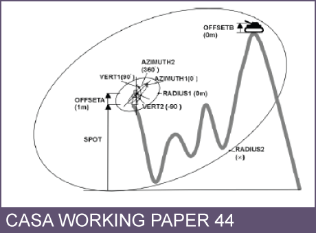
CASA Working Paper 44
CASA Working Paper 44. 1 February 2002. Optimising visibility analyses using topographic features on the terrain. The advantages of using the fundamental topographic features of a surface namely the peaks, pits, passes, ridges and channels as the…
Centre for Advanced Spatial Analysis

CASA Working Paper 45
CASA Working Paper 45. 1 February 2002. Usability Testing for improving interactive Geovisualization techniques. Usability describes a product's fitness for use according to a set of predefined criteria. Whatever the aim of the product, it should…
Centre for Advanced Spatial Analysis

CASA Working Paper 42
CASA Working Paper 42. 1 February 2002. Empiricism and Stochastics in Cellular Automaton Modeling of Urban Land Use Dynamics. An increasing number of models for predicting land use change in regions of rapid urbanization are being proposed and built…
Centre for Advanced Spatial Analysis

CASA Working Paper 43
CASA Working Paper 43. 1 February 2002. Surface Networks. The desire to understand and exploit the structure of continuous surfaces is common to researchers in a range of disciplines. Few examples of the varied surfaces forming an integral part of…
Centre for Advanced Spatial Analysis

CASA Working Paper 46
CASA Working Paper 46. 1 February 2002. Summary of Coral Cay Conservation's Habitat Mapping Data from Utila, Honduras. The coral reefs of Honduras are of vital national and international importance, both ecologically and economically, but are…
Centre for Advanced Spatial Analysis

CASA Working Paper 40
CASA Working Paper 40. 1 January 2002. Classification Methods for Spatial Data Representation. It is necessary to classify numerical values of spatial data when representing them on a map and visually understanding it. In consequence, loss of…
Centre for Advanced Spatial Analysis