Close
Close

CASA Doctoral Summer School for Advanced Spatial Modelling: Skills Workshop and Hackathon
21 August 2019–23 August 2019, 10:00 am–6:00 pm

CASA will be hosting a series of workshops for doctoral students from 21-23 August at UCL.
This event is free.
Event Information
Open to
- UCL students
Availability
- Sold out
Cost
- Free
Organiser
-
CASA PhD
Location
-
B.091-19 Torrington PlaceLondonWC1E 7HBUnited Kingdom
The purpose of the Summer School is threefold: firstly, to warm participants up to key quantitative methods and introduce them to core spatial modelling methods; secondly, apply these methods in the context of National Industrial Strategy - and in doing so, think about new governmental geography products and what future cities could look like; finally, foster collaborations opportunities between PhD students from different institutions through the hackathon and subsequent conference attendance award.
The techniques covered in this summer school come from geographical analysis and the hackathon on urban and infrastructure problems will be an opportunity to apply these.
To find out more about the Summer School, visit the website.
Syllabus and Tutors
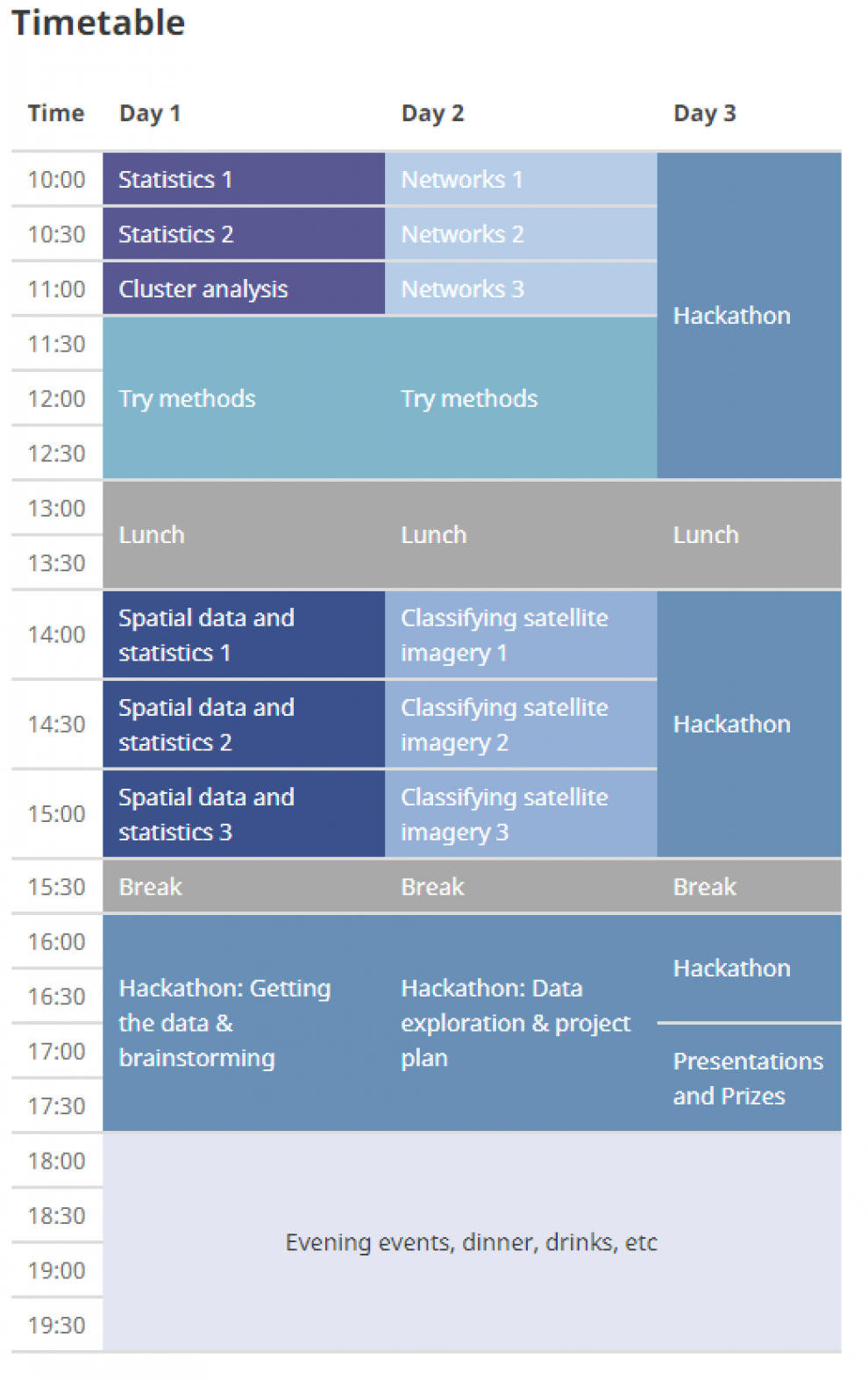
The objective of the syllabus is to warm participants up to key quantitative methods and then introduce them to core spatial modelling methods. There will be a strong focus on demonstrating these methods with code snippets. Participants will see live coding examples they can experiment with and build upon for the hackathon. Over half the lesson time on the first two days is assigned to hands on coding and teamwork with the support of the course tutors.
Day 1
Day 1 will start by introducing important statistical measures, modelling techniques and cluster analysis. The second part of the day will cover working with vector spatial data and key spatial statistics.
Statistics 1: Zara Shabrina
Summarise and compare data visually
Simple linear regression
Statistics 2: Dr Georg Hanh
More regression models:
ANOVA, Logistic and Multiple Linear
Cluster analysis: Dr Thomas Oléron Evans
Similarity metrics
K-means, median and modes
Measures of quality
Spatial data and statistics 1: Bonnie Buyuklieva
UK administrative geographies
Spatial autocorrelation and interaction
Spatial data and statistics 2: Dr Robin Lovelace
Spatial data formats
Coordinate Reference Systems and Re-Projections
Spatial data and statistics 3: Dr David Murrell
Point Pattern Analysis
Spatial hypothesis testing
Day 2
Day 2 will start by covering the skills required to perform network analysis on geographic data. The second part of the day will cover working with raster data and satellite imagery.
Networks 1: Obi Sargoni
Directed vs undirected graphs
Adjacency matrices, node degree
Degree distribution
Connectivity
Networks 2: Dr Elsa Arcaute
Centrality and betweenness
Networks 3: Dr Neave O'Clery
Economic networks
Classifying satellite imagery 1: Matt Ng
Intro to satellite data
Stack, mosaic and clip raster data
Classifying satellite imagery 2: Dr Maxim Chernetskiy
Raster data classification
Classifying satellite imagery 3: Dr Andy MacLachlan
Working with Earth observation data
Applied Urban Heat Island analysis
Day 3
Hackathon!!!
The last day is dedicated to working collaboratively to explore a research question by applying the methods covered in the summer school to spatial datasets. This will give participants the opportunity to practice the skills they have learnt with the support of their peers and summer school tutors.
Time has been set aside on the first two days of the summer school for exploring the datasets and formulating a research question. Road network data, satellite imagery data and point locations data will be provided for teams to work with but teams are also welcome to work with other spatial datasets.
Prizes for winning hackathon teams are:
First Prize: Tickets to GISRUK 2020
Second Prize: Signed copies of Michael Batty's "Inventing Future Cities
Hackathon teams will be judged on the following criteria:
Application of spatial modelling techniques
Did the team apply apply a variety of methods suitably, going beyond the examples presented by tutors?
Addressing a research question
How well did the team address their research question?
Presentation
Did the team produce high quality figures?
Collaboration
Did the team work well together, allowing all team members to contribute to the work?