 Close
Close

Space Syntax Lab Seminars
09 June 2022, 4:00 pm–5:00 pm
Please note the lecture on Thursday 9 June has been postponed due to unforeseen circumstances. This academic seminar series features researchers sharing their findings, discussing their ideas and showing work in progress from The Bartlett's internationally renowned Space Syntax Laboratory.
Event Information
Open to
- All
Organiser
-
Dr Kimon Krenz
About
The Space Syntax Lab Seminar series brings together researchers and students to share their work at the intersection of architecture, urban space and society. Organised by The Bartlett’s internationally renowned Space Syntax Laboratory, the series features a mixture of international invited speakers, UCL researchers and PhD students providing diverse viewpoints on how we understand, analyse and design both buildings and cities.
Schedule
- 28 October 2021 | 16:00 | Lars Marcus
Spatial Capital - How the Spatial Form of the Cities Creates Value in Urban Land and Processes
The concrete outcomes of urban planning and design are built form and spatial structure, which offer long-term support and direction to social, economic and ecological urban processes. Hence, the urban form of our cities is a prime element for building sustainability and resilience into our future cities.
Based on space syntax theory and methodology, as well as original additions to that, new knowledge has over the last decades been contributed by Swedish research groups at KTH and Chalmers to the understanding of the link between spatial form and urban processes. This has informed both public and private practices in urban planning and design, and these methods today are extensively used by both municipalities and consultancies in Sweden.
More recently, there has been a growing focus on how this also generates extensive value, both in the form of use value and exchange value. In the first sense by enhancing the performance of most urban processes, in the second primarily by substantially increasing land values, which forms a major part of the collateral in the global credit system. In both senses one may speak of a spatial capital essential for both everyday life and the performance of urban processes, but also for the global economy.
The lecture will give examples of both methodological developments of space syntax and empirical applications on both social and ecological processes in cities, but will also present new tools aiming at more informed urban planning and design practice, currently tested in Swedish municipalities, where the aim is to also integrate calculations of the economic value of such interventions, thereby, so to speak, capturing the value of the spatial capital created in these practices.
Biography
Lars Marcus is Professor in Urban Design at Chalmers University of Technology and has led the development of internationally high-ranked research groups in Spatial Morphology at both KTH in Stockholm and at Chalmers in Gothenburg. He has also been responsible for the development of master programs and master courses both at KTH and Chalmers based on this research.
In 2018 he finished a large international collaboration with UCL and TU Delft, creating a unique research infrastructure for comparative studies of spatial urban form. In recent years he has been deeply involved as expert advisor in Scandinavia’s largest urban development project, the RiverCity in Gothenburg. Currently he is as vice Director for Research at the department of Architecture and Civil Engineering deeply involved in the reorganization of the department, aiming at greater integration of the knowledge cultures in architecture and engineering.
He is founder and partner of the consultancy Spacescape, that has broken new ground in Sweden for architectural services by offering analytical support on the spatial form of cities to municipalities, real estate developers and architectural firms. Over the last ten years Lars has also extensively participated in Swedish public debate in public and professional press.
- 18 November 2021 | 16:00 | Francesca Froy
'A Marvellous Order': The Spatial and Economic Structures That Make Agglomeration Economies Work in Greater Manchester
In this seminar Francesca Froy will explore the value of combining space syntax analysis with economic network analysis to better understand the functioning of urban economies. She will focus on Greater Manchester in the UK, and its clothing and textile industries. While urban economies are celebrated for their economic diversity, this diversity is not random, with certain industry sectors being more likely to interrelate with each other in cities and share skills, knowledge, and products. These preferential relationships have been mapped by economic network analysts to build models of ‘industry relatedness’. Francesca draws on these models while also exploring how the spatial configuration of Greater Manchester’s street network has supported the realisation of economic synergies between industries both in the past and present.
Biography
Francesca Froy has just completed a PhD at UCL’s Space Syntax Lab. She is a Visiting Lecturer on urban economies at the Bartlett School of Planning and an Honorary Policy Fellow at the UCL Institute for Innovation and Public Purpose. Her research centres on the use of network theory to better understand economic diversity and complexity. Before returning to academia, Francesca worked for over 20 years in the field of policy research and advice, and until 2015 she was a senior policy analyst at the Organisation for Economic Cooperation and Development (OECD). Her articles can be found in a number of peer-reviewed academic journals including the Oxford Review of Economic Policy and the European Planning Journal.
- 2 December 2021 | 16:00 | Ha Minh Hai Thai
The Economic Significances of Informal Alleyways
Dr Ha Thai explains his investigations into spatial settings of informal neighbourhoods and their influences on inhabitants’ economic wellbeing. He focuses on Hanoi, the capital city of Vietnam, characterised by spontaneous urban developments and a mix of various urban morphologies.
The study employs a mixed methodology adapted from space syntax, urban morphology, observation and interviews, to map and analyse an overlooked element of built form, that is a dense network of informal alleyways connecting homes to local main streets. Such system of pathways and its spatial conditions are shaped by inhabitants’ everyday activities, and can significantly facilitate or constrain their opportunities to establish and conduct income-generating activities within their homes. The study suggests the needs for improving space syntax axial map and analysis at neighbourhood scale, demonstrates the utility of the mixed methodology in examining the fine-grain urban settings, and highlights the various impacts of urban physical form on city’s and citizens’ economic wellbeing.
Biography
Dr Ha Thai is a sessional postdoctoral researcher at RMIT’s School of Architecture and Urban Design (Australia). He received his PhD in architecture and urban design from RMIT, Master’s in urban design from Newcastle University (UK) and Master’s in architecture from Hanoi Architectural University (Vietnam). His current research interests include space syntax, urban morphology, building typology, Asian urbanism, temporary and tactical urbanism, and smart city.
- 27 January 2022 | 16:00 | Constance Desenfant
A Gendered Perspective on The Sensory Log of Space:
Perceptions of fear and safety for women exploring and navigating public spaces and their relationship with morphological characteristics of the built environment.
Constance Desenfant’s research focuses on the experience and perceptions of women navigating through public spaces and aims to find ways to improve these spaces to make them more accessible and inclusive. The research focuses specifically on public spaces located within contemporary residential developments in urban locations. Some factors such as female spatial cognition and the perception of fear or safety seem to affect women’s navigation through these spaces and the literature review indicates that these factors are related to the feeling of being surrounded by space and people (Listerborn, 1999; Miranda and van Nes, 2020).
For this reason, the research aims to develop innovative ways of analysing public spaces so as to capture the idea of co-presence, of virtual community and degree of urbanity. To do so, the thesis explores on one hand, how women respond to specific morphological characteristics of the built environment. On the other hand, the thesis interrogates parameters related to the urban scale, to understand how the configuration of the urban network might also affect the perceptions experienced within it. By doing so, the research aims to provide a new insight in terms of morphological variability and how it affects women’s perceptions and navigation in public spaces. It aims to offer some guidance to improve the experience and access to public spaces to women and make a methodological contribution by bringing together spatial and sensorial analytic tools and methods through a hybrid approach including both qualitative and quantitative experiments.
Biography
Constance Desenfant studied architecture at Nantes School of Architecture (ENSAN - France) and Universidad Politecnica de Valencia (UPV – Spain) before graduating from her Master’s in 2014. She moved to London to work as an urban designer in 2015 and has since been working on master planning and infrastructure projects for Weston Williamson + Partners.
In 2018 Constance started her PhD at The Bartlett School of Architecture, UCL, as a part-time student, while still working as an urban designer. She is a feature editor for Design Exchange and has been a guest panellist and assistant tutor at the University of Nottingham, London Metropolitan University, and University of Paris Malaquais.
- 10 February 2022 | 16:00 | Ahmed Tarek Zaky Fouad
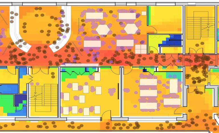
Implications of the Spatial Design of School Buildings on Student Interactions and Student Self-Directed Learning Activities
The importance of school buildings is rooted in the vitality of education for societal development. Literature perceives learning as a social process, enriched by student interactions and self-directed activities, and the school design should afford those learning practices. Therefore, research on school buildings requires investigating the spatial design to uncover the design potentiality and the actuality of school operation. This investigation outlines the research scope, while more attention is drawn towards informal learning spaces outside classrooms: corridors, libraries, dining spaces and play areas.
This research performed quantitative spatial analysis on eleven UK secondary schools, designed by three architecture firms; and qualitative interviews with architects from those firms. This explored the design potentiality for possible learning opportunities. The research proceeded to study two (of the eleven) buildings through quantitative onsite observations and student questionnaires; and qualitative interviews with the school managements and teachers. These explained the actuality of occurring student interactions and self-directed activities, relative to managerial regulations, teacher guidance and supervision and student preferences.
Findings discussed the influence of functionalities allocation, configurational accessibility and the furniture setup on the student activity types and distribution. Nevertheless, regulations, supervision and student preferences still influenced the occurring activities. Shallow corridors afforded interactive learning when connected to open learning spaces. Libraries incubated collaborative or quieter (and focused) self-directed activities. Dining spaces accommodated student intellectual practices beyond eating activities. Play areas had the highest activity diversity. The research outcome explained the school operations, and their correspondence to (or divergence from) the original design potentiality. This contributes to existing knowledge on the student social life in schools, and how the spatial design and school rules impact activity types across informal spaces. This possibly links to future work on interactive design processes as a methodology that reduces the gap of understanding between design intentions and actuality.
Biography
Dr Ahmed Tarek Zaky Fouad has been involved in architecture design and research for more than 10 years, with particular emphasis on building analysis and evaluation since he started his master’s in 2015 followed by a PhD in architecture at The Bartlett - University College London. Alongside his prolonged research on the spatial design of school buildings and its implication on student activities, Zaky participated in further research projects on educational buildings and other public buildings such as hospitals, using space syntax theories and tools and diverse observations and surveying techniques, aiming to optimise building operations through empirical data and design interventions. Moreover, as a trained researcher and educator, and being qualified as an Associate Fellow for teaching in higher education from the UK Higher Education Academy, Zaky disseminated his knowledge through various teaching activities of lectures, discussion sessions and tutorials for undergraduate and postgraduate students, alongside multiple research conferences and seminars for architecture professional practices. As a trained architect, he also participated in the design of 10+ residential and commercial buildings, with much focus on the user experience, needs and preferences.
Alongside his passion about architecture research and design, Zaky is equally interested in sustainable means of fashion consumption. He launched a sustainable fashion platform in Oct 2021, named ‘Booji’, to promote fashion items sharing and provide peer-to-peer fashion renting services.
- 24 February 2022 | 16:00 | Gareth Simons
Detection and Prediction of Urban Archetypes at the Pedestrian Scale
Granular, dense, and mixed-use urban morphologies are hallmarks of walkable and vibrant streets. However, urban systems are notoriously complex and planned urban development, which grapples with varied interdependent and oft conflicting criteria, may — despite best intentions — yield aberrant morphologies fundamentally at odds with the needs of pedestrians and the resiliency of neighbourhoods. Gareth will discuss methods for high-resolution analysis of network centralities, land-use accessibilities, mixed-uses, and statistical measures using spatially precise workflows. He will give examples from the cityseer-api Python package and will illustrate how spatial-analytic methods can be combined with machine learning to extrapolate contextually sensitive spatial signatures. These methods use complex systems thinking to bridge qualitative and quantitative conceptions of urbanism, and can be tailored towards helping urban design professionals better anticipate the outcomes of varied design scenarios as part of iterative and scalable workflows.
Biography
Dr Gareth Simons is an urbanist with expertise in computational urban morphological methods. His interests centre on micro-morphological spatial analysis that can be applied to granular data sources at a sufficiently high resolution to make contextual observations in a manner that is useful for masterplanning and urbanism. Previously an architect, Gareth worked for a decade in the extreme winter climes of Winnipeg, Canada . He now works for the Building Stock Lab (UCL, Bartlett, Energy Institute) as part of a team developing national scale models of the building stock for purposes of energy use analysis and targeted reductions.
- 10 March 2022 | 16:00 | Martin Bielik
Cleaning the Mess: When urban economists, transportation planners, and urban morphologists use different models to explain the same phenomena
The ability to assess the long-term impact of urban planning decisions on what people do and how they get there is of central importance, with various disciplines addressing this topic. In this lecture, Martin will explore approaches proposed by Space Syntax scholars, urban economists, and transportation planners, each aiming the attention at a different part of the form-activity-movement interaction. Martin will address the costs of ignoring the effects of some interactions while considering others and present an empirical study quantifying the bias of the individual models.
For this purpose, he proposes an integrative form-activity-movement interaction model and estimates how the urban form and activities affect movement as well as how movement and urban form affect activities. He shows that by estimating these effects in isolation and simultaneously, we can assess the bias of the individual models.
The relevance of Martin’s research is being twofold. On the one hand, he proposes a methodological framework for the simultaneous estimation of the form-activity-movement interactions. On the other hand, he provides empirical evidence about the strengths and limitations of current approaches.
Biography
Dr Martin Bielik is a Postdoctoral Researcher at the Chair of Computer Science in Architecture and Urban Planning at the Bauhaus University Weimar, Germany. He is also an associate investigator at Emerging Cities Lab in Addis Ababa with a research focus on mobility in the context of rapid urbanization. He graduated in architecture and urban planning in 2011 from the Faculty of Architecture, Slovak University of Technology, work as a researcher and consultant, and earned his doctoral degree in 2021 at Bauhaus-Universität Weimar. His main research interest is the analysis and simulation of socio-economic activities in urban systems and the application of these methods in the planning process and policymaking.
Register for Martin Bielik's LectureMartin is also co-founder of the DecodingSpaces - consultancy and developer of analytical and generative tools for architecture and urban planning.
- 24 March 2022 | 16:00 | Isabelle Soares
Assessing the relationship between spatial configuration, perceptions and uses of Dutch university campuses’ public spaces, through the lens of the fourth sustainability, creativity
In this seminar, Isabelle Soares will discuss and explore socio-spatial aspects of creativity of Dutch university campuses public spaces, with the empirical evidence of the Zernike campus Groningen. Based on Bill Hillier’s (2016) theory of ‘creativity as the fourth sustainability’ and Peter Meusburger’s (2009; 2015) ‘milieus of creativity’ theories, this research empirically investigates how the physical environment can play a role in creative encounters, demonstrated here as the acts of ‘spontaneous encounters’, ‘socialisation’ and ‘meeting people from outside the university’ in public spaces.
This study recognises that creativity is the fourth sustainability because the spatial configuration of campuses and city-university accessibilities are ‘creative solutions’ conceived for human needs. At the same time, the generation of creative ideas occur in situated environments, spatial structures, and depend on interactions between individuals and the built environment (Soares et al. 2020). Through a mixed methodology that involves (1) space syntax analysis of the campus masterplan spatial configuration, (2) volunteered geographic information (VGI) of the users’ perceptions, and (3) non-participatory observations of people-environment interactions in public spaces with high and low ‘potential for creativity’, this research highlights that creativity and space are in constant co-evolution and that creativity cannot be explained only by campuses’ spatial configurations and potential through-movement. Creativity and creative interactions are facilitated by the combination of the land-use mix, physical features, positive experiences, and perceptions of a sense of place which enable trust and interactions.
Isabelle will also briefly present some insights of the interface between research and practice, since as part of her PhD she not only investigated through spatial data analysis the relationship between spatial configuration, perceptions and uses of public spaces but also, she presented and discussed such research-generated evidence with practitioners to understand how such evidence was perceived as credible, relevant and applicable for practice.
Biography
Isabelle Soares is an international and interdisciplinary researcher about to finish her PhD research at the University of Groningen, Department of Spatial Planning & Environment. She is currently a temporary lecturer in Planning Theories at Leibniz University (Hannover, Germany).
Her research focuses on the understanding of socio-spatial aspects of creativity in knowledge environments such as university campuses, including the uses and perceptions of people in public spaces. She is interested in the users’ perspective (using public participatory GIS and spatial data analysis) but also in the interface between planning practice and research. For instance, how research-generated evidence is applied in the decision-making, planning and design of public spaces. Isabelle holds a Master in Urbanism (University Mackenzie, São Paulo) focused on active mobility and the urban design of the surroundings of multimodal transportation nodes. She also worked few years in practice with urban design and architecture. She has academic publications in peer-reviewed journals, and now she is mostly interested in the interface between practice and research.
- 28 April 2022 | 16:00 | Paolo Santi
Using Mathematical Models to Predict Urban Mobility Patterns
Understanding the patterns underlying human mobility in urban areas is essential to better plan cities, engineering traffic, and mitigating diseases. In this talk, Paolo Santi will show how cell phone data can be used to characterize and model urban mobility at different spatial scales. Initially, he will show the use of cell phone data records collected in different countries to study the relationship between distance and frequency of a visit: how frequently do we visit a particular place? And, how is this visitation frequency related to the distance we traveled? Modeling the interplay between spatial and temporal features of mobility is critical; for instance, it can provide urban planners with the information to best place a shopping mall to attract customers. Then, will show how a data set of higher resolution GPS traces can be used to model fundamental features of urban pedestrian navigation: deviation from shortest path, asymmetry, and vector-based navigation. Throughout the talk, Paolo will discuss our findings in relation to prevalent location and planning theories such as Central Space Theory and Space Syntax.
Biography
Paolo Santi is Principal Research Scientist at MIT Senseable City Lab where he leads the MIT/Fraunhofer Ambient Mobility initiative, and a Research Director at the Istituto di Informatica e Telematica, CNR, Pisa. Dr. Santi holds a “Laurea” degree and the PhD in computer science from the University of Pisa, Italy. Dr. Santi is a member of the IEEE Computer Society and has recently been recognized as Distinguished Scientist by the Association for Computing Machinery. His research interest is in the modeling and analysis of complex systems ranging from wireless multi hop networks to sensor and vehicular networks and, more recently, smart mobility and intelligent transportation systems. In these fields, he has contributed more than 170 scientific papers and two books.
- 12 May 2022 | 16:00 | David Fredrick & Rhodora G. Vennarucci
Catching Wise: Toward a New Understanding of the Roman House through Holistic Environmental Modeling
In a landmark publication in 1994, Houses and Society in Pompeii and Herculaneum, Andrew Wallace-Hadrill established an enduring interpretation of the Roman house as “power-house,” with the elite male owner, the dominus, firmly atop a social hierarchy from the enslaved through clients, friends of comparable status, and family members. Domestic space and decoration should be viewed as finely tuned to articulate and enforce this hierarchy, and the privileged position of the dominus within the house, and society more broadly. Although applied widely to archaeological sites – including Pompeii – when exploring space as social phenomenon in the Roman house, space syntax analysis is of limited utility because it does not account for decoration. In this seminar, David Fredrick and Rhodora Vennarucci, co-directors of the Virtual Pompeii project, will outline their revised methodology that combines social network measures (generated with a workflow in Gephi and ArcGIS) with the analysis of movement patterns of human subjects, captured while navigating digital 3D models of fourPompeian houses, designed in Unity3D. The project’s preliminary results highlight the important role decoration has in shaping movement, suggesting that the Roman house was indeed a power-house. The data also indicates, however, that power within the house may have flowed in unexpected ways through decentralized, fluid, and dynamic networks, reflecting the often-overlooked agency of its “passive” members, such as the enslaved and women. This project demonstrates the need to move toward a holistic environmental modeling framework that integrates qualitative predictive and qualitative phenomenological data when investigating the complex socio-spatial dynamics at play in the Roman house.
Biography
David Fredrick is an Associate Professor in Classical Studies at the University of Arkansas. Prof Fredrick directed the Tesseract Center for Game Design at the University of Arkansas from 2014-2021, and is currently working to build a new Digital Humanities and Game Design Studio in the Department of World Languages, Literatures, and Cultures. Through Tesseract, he directed the production of video games and interactive visualizations for teaching and research, with projects that include modeling space and movement in ancient Pompeii, Native American languages and culture, experiences of captivity, trauma, and resilience in the Arkansas Delta during WWII, and the emergence of Black institutions in early 19th-century Brooklyn. In 2015, Tesseract's interactive gallery application for Crystal Bridges Museum of American Art received a Golden Muse Award from the American Alliance of Museums, and in 2021 Mornin' in Your Eyes, a video game developed to teach Civil Rights history, received a Silver Award in the Serious Games competition. In 2013, Fredrick received the Excellence in Teaching award from the Honors College of the University of Arkansas; in 2004 he received the national Excellence in Teaching award from the American Philological Association, now the Society for Classical Studies.
Rhodora G. Vennarucci is an Assistant Professor of Classics and Art History at the University of Arkansas. Her main research focus lies in the socio-economic history of the Roman world with published and forthcoming works focusing on both ends of the distributive system in Italy: rural multi-craft production and urban commercial landscapes. She co-directs the Marzuolo Archaeological Project, which investigates the dynamics of a Roman rural minor center in South Central Tuscany, and she is the scientific director of the Virtual Roman Retail project, which uses immersive VR technology to explore how shop design shaped ancient consumer experience and behavior. As a co-director on the Virtual Pompeii project, she has contributed to the development of a holistic environmental modeling framework that combines predictive analyses (e.g., space network analysis) with experiential modeling in 3D visualizations (e.g., movement patterns) to explore the relationship between spatial configuration and social phenomena in the Roman house.
- 26 May 2022 | 16:00 | Lingzhu Zhang & Alain Chiaradia
Walking in the Cities Without Ground, How 3D Complex Network Volumetrics Improve Analysis
Volumetric urban design is an urban phenomenon where urban block envelopes traditionally limited by property line are pushed horizontally beyond the envelope below and above ground forming proliferating multi-level-built network. Volumetric urban design is often associated with high density and transport-oriented development. Such walking volumetric multi-level environments are challenging to understand, model and design for pedestrian. The talk will explore, along space syntax spatial models, a large-scale 3D centreline pedestrian network which implement transport geography 2D data model principles in 3D including indoor and outdoor. The talk investigates the relationship between pedestrian flow and volumetric configuration analysis from 2D to 3D with various level of definition. Concluding by reframing the study with emerging theories, the wider values urban design and transport.
Biography
Dr Lingzhu Zhang is an Assistant Professor at the College of Architecture and Urban Planning, Tongji University, Shanghai. Her research combines creatively network-science, images analysis un/supervised machine learning research techniques to objectively describe the built environment and investigate urban design and public realm design impacts on liveability and vitality in dense city.
Alain Chiaradia is an Associate Professor of Practice and Deputy Head at the Department of Urban Planning and Design, Faculty of Architecture, the University of Hong Kong. He is Programme Director of the Master of Urban Design and the Master of Science in Urban Design and Transport. Alain develops 3D network-based urban morphometrics to capture the impacts and values of urban design. He was the concept lead of 3D sDNA software (http://www.cardiff.ac.uk/sdna/). He has 20-year experience in deploying network-based configurational analysis of layout complexity in research and action research. From 2000, he was University College London (UCL), Honorary Senior Research Fellow, and Director and Board Director at Space Syntax Ltd from 2005-09. His recent research integrates multiplex approach (rail, road, pedestrian) to city spatial configuration analysis.
- Postponed 9 Jun 2022 | 16:00 | Rosica Pachilova & Kerstin Sailer
Due to unforeseen circumstances this event has now been postponed.
Reconfigurable Diagnostics Hub
Current practice of eye examinations at Moorfields Eye Hospital were investigated with the aim to optimise the flow of patients in time and space. This will respond to the huge backlog in outpatient services for Moorfields patients caused by the restrictions in clinical activity during the Covid pandemic. In addition to their current Cayton Street site, a new hub in Hoxton was opened in January 2021 to catch-up with the Covid-induced patient backlog. Clinicians reported that neither site runs optimally, as examinations take longer than expected, yet it is not known where time is lost. Based on observations and space syntax modelling, Rosica and Kerstin investigated the spatial and temporal configurations for time-efficiency and adaptability. Using the findings from this study to suggest spatial arrangements for an optimized flow in another Moorfields clinic opened in September 2021 in Brent Cross Shopping Centre.
Biography
Kerstin Sailer is a Professor in the Sociology of Architecture at The Bartlett School of Architecture, UCL. She investigates the impact of spatial design on people and social behaviours inside a range of buildings such as offices, laboratories, hospitals and schools. An architect by training, her research interests combine complex buildings, workplace environments and space usage with social networks, organisational theory and organisational behaviour. She has published widely, and her research has been funded by both industry and various research councils. Kerstin is the Principal Investigator of the Reconfigurable Diagnostics Hub project.
Dr Rosica Pachilova is a Research Associate for the Reconfigurable Diagnostic Hubs project and will present research findings of the project on behalf of Kerstin. Rosica finished her PhD at UCL in 2020, where she investigated how hospital ward layouts influenced work processes and communication patterns amongst healthcare workers and how this affected the quality of care provided to patients. Together with Kerstin Sailer, she won the RIBA President Award for Research in 2019 in the annual theme ‘Building in Quality’. Rosica currently works for a Workplace Consultancy where she is involved in healthcare, office and education building projects. She helps understand user behaviours by gathering qualitative and quantitative data, looks into global best practices and future trends, and translates this into design.
More information
- Space Syntax: Architecture & Cities MSc/MRes at The Bartlett School of Architecture
- Find out more about the Space Syntax Laboratory
- Watch previous seminars on The Bartlett Vimeo Channel
Image: School Floorplan Accessibility with Student Activites in Space - Dr Ahmed Tarek Zaky Fouad