Archaeology South-East has a highly qualified and experienced team of field staff and managers. We are a commercially sensitive organisation but our association with UCL Institute of Archaeology, one of the highest ranking university departments in the subject of Archaeology, means we combine competitive pricing with academic excellence. Our extensive experience of working within the UK construction industry and planning framework allows us to provide fieldwork services tailored to your needs, from watching briefs to fully managed large scale excavation projects.
ASE also undertakes grant-funded fieldwork projects within the UK, and both commercial and grant-funded fieldwork projects internationally. All of our staff carry CSCS cards and have appropriate construction site experience and hazard training for the work they undertake.
Please use the drop-down menu below to see a more detailed description of the various types of fieldwork we undertake and technologies we use.
- Project Management
Project Management
Archaeology South-East has a highly experienced project management and pre-works documentation team, able to guide your project to a successful conclusion. All of our project managers have had extensive experience of running fieldwork projects prior to managing them, and all are Members of the Chartered Institute for Archaeologists (MCIfA), our professional body. The role of our Project Managers is to manage the delivery of a safe, quality service and product at a competitive price.
Written Scheme of Investigation (WSI)
The submission of a Written Scheme of Investigation (WSI) prior to the commencement of fieldwork is required by planning authorities and statutory bodies. The WSI sets out the reasons why the work is being undertaken, the archaeological background and research aims and the methodology by which the fieldwork and reporting will be carried out. The WSI then becomes a planning document and the archaeological contractor and client are bound to the methodology which it describes.
Risk Assessment and Method Statement (RAMS)
Prior to the commencement of works ASE produces a Risk Assessment and Method Statement (RAMS) which outlines the sites conditions, the method by which we will be working, an assessment of the risks involved in that work, and means by which those risks can be reduced or eliminated. The document is further updated by our site staff and/or project manager should circumstances change on site. Archaeology South-East is an approved contractor under the Contractor Health and Safety Assessment Scheme (CHAS) and all of our staff are confirmed as being appropriate trained to work on construction sites through the Construction Skills Certification Scheme (CSCS).
- Trial Trench Evaluation
Machine or hand excavated trial trenches provide a means of sampling a large area to record the density of archaeological features and finds and determine levels of recent disturbance such as topsoil stripping or landscaping. Trial trench evaluation is also employed to test the results of geophysical and topographic survey. Typically planning authorities request that the pattern of trial trench evaluation evenly covers around 5% of the area to be impacted by the development.
As with non-invasive methods such as geophysical survey, field-walking and survey, evaluation can help to identify the archaeological potential of a site and to locate specific zones of activity within the site. If geophysical and/or topographic surveys are conducted prior to Trial Trench Evaluation this can potentially reduce the amount of evaluation work required and help to locate evaluation trenches more effectively.
- Archaeological Mitigation (Excavation)

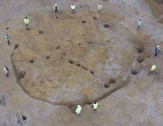
Once a site has been evaluated and found to contain archaeological features or finds, the planning authority can insist these be subject to excavation prior to the commencement of construction works. Archaeology South-East has over 25 years experience of effectively running archaeological excavations to increase our collective knowledge of past societies whilst providing an efficient and competitive service to our clients.
The process is overseen by one of our fieldwork project managers and the excavation is conducted by one of our experienced site directors supervising a team of archaeologists. Throughout the excavation, we liaise closely between the client and relevant planning or statutory body to avail them of any significant findings and to ensure the archaeological works and undertaken on time and within budget. Our project managers can offer advice as to the financial risk associated with archaeological excavation and can assist in the programming of fieldwork within wider construction programmes.
- Watching Briefs
An archaeological watching brief is a programme of observation and investigation designed to record potential archaeological remains exposed, disturbed or destroyed during ground works. In order to avoid unexpected problems and delays it is important that archaeological attendances are carefully scheduled into the construction programme. Our Project Managers take particular care to anticipate and avoid risk at all stages in the planning and delivery of fieldwork attendances. Watching briefs may lead to further fieldwork should significant archaeological material be exposed.
- Geomatics & Geophysical Survey
Geomatics
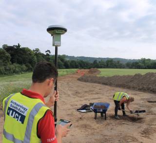
Archaeology South-East offers a full range of survey options for known and prospective archaeological sites, using the most contemporary digital survey hardware and software (DGPSS and Total Station). Our dedicated team of surveyors are able to rapidly record archaeological features during fieldwork, reducing the time traditionally taken by hand-planning and vastly improving accuracy. ASE also operates an airborne photogrammetric modelling system mounted on a remote controlled aircraft, which is able to undertake larger landscape surveys in suitable areas.
Topographical Survey

Archaeological topographic survey is the close point survey of known or prospective archaeological earthworks to aid archaeological interpretation or to form a digital/drawn record to monitor areas against natural or manmade erosion. The combination of ASE's geomatics and heritage management teams allow for rapid in-house production and interpretation of topographic surveys.
Geophysical survey can be a powerful, low cost and unintrusive tool that can rapidly evaluate a site's archaeological potential. Geophysical survey is especially successful at identifying the remains of buildings, metallic finds and areas that have been subject to heat. However, the results of Geophysical survey are not always conclusive, especially when detecting prehistoric features with fills similar to the background geology. This uncertainty often requires the results of surveys to be 'ground truthed' by test pits or evaluation trenches. ASE has a dedicated geophysical survey team that can undertake Magnetometry, Resistivity and Ground Penetrating Radar Surveys. Our team also has expertise with other remote sensing techniques such as Magnetic Susceptibility and LiDAR.
The geophysical data collected in the field are downloaded into software created specifically for geophysics and processed and then interpreted by our staff. The geophysical services provided by Archaeology South-East are fully integrated with our other survey techniques, allowing for a comprehensive and effective reporting procedure.
- Aerial photography and UAV survey
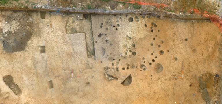
The use of Unmanned Aerial Vehicles (UAVs) in archaeology and heritage management is rapidly increasing and it is becoming one of the mainstream documentation tools in archaeological practice. ASE has been a Civil Aviation Authority approved commercial operator of Small Unmanned Aircraft since May 2018, and subsequently have been engaged in aerial topo-surveys, site aerial photography and photogrammetry. Our team collaborate with several research initiatives on aerial remote sensing based at UCL Institute of Archaeology and some of the world's largest archaeological sites - including Olduvai Gorge in Tanzania and Ancient Merv in Turkmenistan - were documented and researched with the direct involvement of our specialists.

The photogrammetric recording of archaeological structures and landscapes generates modelling data that competes with the quality achieved by laser-scanning but at a fraction of the time and cost. The data collected with the use of UAV's is used for documentation, interpretation and management of complex and extensive archaeological landscapes, as well as smaller archaeological features.
Our specialists are benefiting enormously from advanced computing facilities and advances in photogrammetric software to achieve a fusion between the ground level documentation and aerial views of archaeological sites and standing historical buildings. We use several fixed-wing and multi-rotor solutions and a diverse range of cameras and sensors in our work. Our use of aerial photography and aerial remote sensing is driven by the needs of specific projects for documenting, understanding and managing a wide range of heritage assets.
- Coastal and Marine Archaeology
Archaeology South-East is able to help with projects involving coastal and marine archaeology. We have staff qualified in the survey of inter-tidal areas, and we work with specialist sub-contractors in recording and managing under-water sites. Our aim is to provide clear guidance on the archaeological implications of projects affecting estuarine, coastal and offshore resources - using a similar suite of techniques and approaches to those that inform our terrestrial work. We are guided in this work by our academic colleagues at the Institute of Archaeology .
Past clients include the Port of London Authority, P&O, Kent County Council, Babtie and Royal Haskoning. ASE has also produced a benchmark report on behalf of Historic England, which reviews the suite of projects funded by the Aggregates Levy Sustainability Fund, including recent fundamental research on maritime heritage.
- Fieldwalking
Fieldwalking (or Surface Artefact Collection) is a technique suited to rapid initial appraisal of the archaeological potential of a landscape. Typically, archaeologists walk along an ordered grid collecting and recording surface archaeological finds. The identification and spatial analysis of the artefacts collected offers valuable clues to the distribution of archaeological sites and helps in the formulation of subsequent mitigation strategies.
Fieldwalking can be a useful tool on large-scale rural sites, for instance in advance of groundworks for quarries, reservoirs or housing schemes. The obvious problem with the technique is the need for open, preferably recently-ploughed areas for investigation, and hence it is unsuitable for urban or brownfield sites.
- Geoarchaeological and Palaeoenvironmental
Geoarchaeology
Geoarchaeology is a specialist discipline which integrates archaeology, geology and environmental science to study the interaction between humans and the natural environment from the recent past in Britain to nearly a million years before present. Archaeology South-East has Projects Managers and Geoarchaeological specialists experienced in all aspects of geoarchaeological fieldwork that can make a correct assessment on how best to design and implement an appropriate sampling strategy.
Through the collection of measured samples it is possible to date and reconstruct previous, or palaeo, environments through the study of palaeoenvironmental indicators (pollen, foraminifera, diatoms, insects, molluscs, plant remains etc) and the formation processes that created the sediments in which they are preserved.
Typically geoarchaeological fieldwork can involve the monitoring of site investigation works, the excavation of deep test pits, the drilling of boreholes or the undertaking of specialist geophysical survey. Observations made during geoarchaeological fieldwork can also be used to create sub-surface deposit models to interpret where significant deposits lie and show whether proposed developments are likely to impact upon them.
Palaeolithic & Pleistocene Services
Archaeology South-East builds on the long research history of the Institute of Archaeology in Palaeolithic studies to offer specialist commercial services in this area. Palaeolithic finds can comprise of stone tools, butchered animals bones, occasional fossil remains left by extinct species of human including Homo Erectus and Neanderthals and related palaeoenvironmental indicators. Palaeolithic deposits can be exceptionally rare and so Palaeolithic discoveries can be of international importance as they provide insights to the human evolutionary journey and the responses of past populations to large changes in the earth's climate over the past million years.
 Close
Close

