
 Chile 1960 May
22 19:11:14 UTC, Magnitude 9.5
Chile 1960 May
22 19:11:14 UTC, Magnitude 9.5
Seismograms
- PDF: Berkeley Long Period Record 78M
PDF: Berkeley Short Period Record 599MPostscript: Berkeley Long Period Record 26,490M
Postscript: Berkeley Short Period Record 24,874M
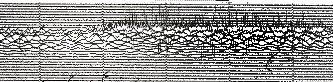
A section of the Berkeley Short Period Seismogram.
NOAA Slide Set
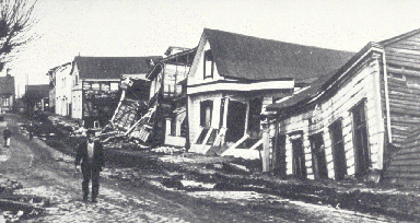
Valdivia suffered catastrophic damage because of its proximity to the epicenter of the massive quake.
More than 2,000 killed, 3,000 injured, 2,000,000 homeless, and $550 million damage in southern Chile; tsunami caused 61 deaths, $75 million damage in Hawaii; 138 deaths and $50 million damge in Japan; 32 dead and missing in the Phillippines; and $500,000 damage to the west coast of the United States.Abridged from United States Earthquakes 1960, by H. Carroll Talley, Jr. and William K. Cloud. U.S. Department of Commerce, Coast and Geodectic Survey.
Near coast of Chile. Magnitude 8.3. More than 2,000 killed, 3,000 injured and $550 million damage in Chile; seismic sea wave caused 56 deaths, $75 million damage in Hawaii; 138 deaths and $50 million damage in Japan; $500 thousand damage to west coast of the United States.From ISC Bulletin, The International Seismological Summary.
The following table lists particulars reported by the Survey for the larger shocks of the series of destructive earthquakes in central and southern Chile which began on May 21 and which is still continuing as of this writing in mid-August. The first large shock of the series, on May 21, 1960 at 10h02m50s, caused many casualties and extensive property damage at Concepcion and surrounding area. The ensuing series of earthquakes and accompanying seismic sea waves caused many casualties and extensive property damage along the central Chile coast between latitudes 36 deg S and 44 deg S. Late press reports estimate that the casualties range from 6,000 to 10,000 persons dead or missing. The main shock (May 22, 1960, 19h11m20s GCT) set up a series of seismic sea waves that not only was destructive along the coast of Chile, but which also caused numerous casualties and extensive property damage in Hawaii and Japan, and which was noticeable along shorelines throughout the Pacific Ocean area. The Chilean government estimated 2,000,000 people homeless and $3000,000,000 property damage as a result of the earthquakes. Destruction was heaviest in the cities of Concepcion, Valdivia, and Puerto Montt, and many smaller towns and villages were virtually demolished. Massive landslides, violent volcanic eruptions and extensive dislocations of the land surface were reported in early press reports from Chile."From Seismological Notes (BSSA). "Seismological Notes" is a list of recent important earthquakes with short summaries included in each issue of the BSSA.
Beginning on 21 May 1960, southern Chile was ravaged by a series of earthquakes whose foci lie within a band 1,300 km long, between latitudes 37deg and 48 deg S. The epicentres follow the main SSW.-NNE. feature, continental in the north, submarine in the south, separating a region which has risen (coast of Lebu) from a vast region which has subsided.The official death roll rose to 660 dead and 717 missing, numbers much lower than those first announced in the press; 58,622 houses were completely destroyed (Tazieff, 1962). Damage was put at $550 million.
A succession of large destructive earthquakes in the space of a few hours made it impossible to draw isoseismic maps. The first shock caused major damage ac Concepcion, especially in the lower parts of the town (intensity IX). Damage was also observed at Talcahuano (intensity IX), Coronel (intensity IX), Lota (intensity IX) and Lebu (intensity X). The shocks of 22 May affected especially southern Chile: Valdivia (intensity X), Puerto Montt (lower town) (intensity X-XI), Rio Negro (intensity IX-X), Temuco (intensity VIII), Osorno (intensity VII-VIII), Puerto Saavedra (intensity VII-VIII), Llanquihue (intensity VII-VIII), Villarica (intensity VII) (Duke and Leeds, 1963; Rothe, 1961).
Important modifications to the coastal relief were observed. Rock falls and landslides occurred in the Andes, forming an artificial lake on the Rio San Pedro, the outlet of Lake Rinihue. The Puyehue volcano erupted on 24 May at about 18 h, 47 hours after the main shock....
A detailed study of the destruction was the subject of a special paper (Housner, 1963).
The main shock set up a large tsunami. Although the warning system worked well, the wave caused 61 deaths, injured 282 and did damage amounting to $20 million on the island of Hawaii (Eaton, et al., 1961; Lachmann et al., 1961). In Japan, the coast of Honshu was ravaged (100 dead, 85 missing, 855 injured, 1,678 homes destroyed (Momoi, 1963; Takahasi, 1963; Taneda, 1961). The coasts of California, New Zealand, Australia and Kamchatka were also affected (Rothe, 1961).
From Rothe, J.P., 1969, The seismicity of the earth, 1953-1965: Paris, United Nations Educational, Scientific and Cultural Organization, 336 p.
1960 May 22, 19:11, 39.5W, 74.5W, maximum intensity XI, 2231 deaths or 3000 deaths, or 5700 deaths (different references), $417 million, $675 million, $800 million damage (different references) U.S. at the time of the earthquake. Chile: Alerce, Valdivia, Rinihue, Totoral, Concepcion. Chile: Puerto Montt, Valdivia. References: Bertz, 1988; Munchener Ruckversicherungs-Gesellschaft, 1978; Askew and Algermissen, 1985.From Dunbar, Paula K., Lockridge, Patricia A., and Whiteside, Lowell S., 1992, Catalog of significant earthquakes 2150 B.C. - 1991 A.D.: U. S. Dept. of Commerce, National Oceanic and Atmospheric Administration.
A devastating earthquake (magnitude 8.6) off the coast of central Chile generated a tsunami affecting the entire Pacific Basin. In general the wave action along Hawaiian shores was quiet, resembling that of the tide, although it had a shorter period and a greater range. It killed 61 and seriously injured 43. In Hilo Bay, however, the third wave was converted into a bore that flooded inland to the 6 m contour. Nearly 240 hectares (600 acres) inland of Hilo harbor were inundated, and all the deaths and $23.5 million of the damage occurred in this area. (The estimates of damage in Hawaii vary from $75 million in Talley and Cloud (1962), to $20 million in Wall (1960). A total of about $24 million for Hawaii is given by the Hawaiian office of Civil Defense.) In nearly half of this area total destruction occurred. In the area of maximum destruction, only buildings of reinforced concrete or structural steel, and a few others sheltered by these buildings, remained standing--and even these were generally gutted. Frame buildings either were crushed or floated nearly to the limits of flooding. Dozens of automobiles were wrecked; a 10-metric ton tractor in a showroom was swept away; heavy machinery, mill rollers, and metal stocks were strewn about. Rocks weighing as much as 20 metric tons were plucked from a sea wall and carried as far as 180 m inland. Damage elsewhere on the Island of Hawaii was restricted to the west and southern coasts, where about a dozen buildings, mostly of frame construction, were floated off their foundations, crushed, or flooded. There was half a million dollars of damage on the Kona coast alone. Six houses were destroyed at Napoopoo.On Maui the damage was concentrated in the Kahului area on the north coast. A warehouse and half a dozen houses were demolished, and other warehouses, stores, offices, and houses, and their contents were damaged. A church floated 6.1 m away from its foundation. Other buildings were damaged at Paukukalo, just outside and west of the harbor. At Spreckelsville and Paia, east of Kahului, houses were damaged, and one house at each place was demolished. Additional damage occurred at Kihei on the south coast and Lahaina on the west coast. On the island of Molokai there was some damage to houses, fish ponds, and roads, and a beachhouse was demolished on the Island of Lanai. The islands of Kauai and Oahu escaped with only minor damage. Fifty houses at Kuliouou, an eastern suburb of Honolulu, were flooded, and $250,000 in damage was done. Elsewhere on Oahu no damage was reported, even where there was inundation of areas occupied by houses. On Kauai, so far as is known, the only damage consisted of one frame building being floated off its foundation on the south coast."
From Tsunami in Hawaii. Lander, James F., and Lockridge, Patricia A., 1989, United States Tsunamis (including United States possessions) 1690-1988: U.S. Dept. of Commerce, National Oceanic and Atmospheric Administration, 265 p.
The great Chilean earthquake with a magnitude of 8.6 generated a wave that was recorded at Massacre Bay (more than 1.7 m), Sweeper Cove (1.1 m), Seward (0.7 m), Women's Bay (0.7 m), Yakutat (0.8 m), Dutch Harbor (0.7 m), Sitka ().5 m), and Skagway (0.2 m). The wave was observed at Kake, Juneau, and Ketchikan. Cox and Pararas-Carayannis (1976) reported 'some cracking of the ice was noted in the afternoon,' but do not give a location. At Cape Pole (55.9 deg N, 133.8 deg W), a log boom was broken by a strong current associated with this tsunami. The runup there was about 1 m at Craig (55.4 deg N, 133.1 deg W), a buoy was moved by the tsunami."From Tsunami in Alaska. Lander, James F., and Lockridge, Patricia A., 1989, United States Tsunamis (including United States possessions) 1690-1988: U.S. Dept. of Commerce, National Oceanic and Atmospheric Administration, 265 p.
A magnitude 8.6 earthquake off the coast of Chile caused $550 million damage in Chile and 1,000 deaths; about $24 million damage in Hawaii (oral communication, Hawaii Office of Civil Defense) and 61 deaths; $50 million damage in Japan and 199 deaths; and about $500,000 to $1,000,000 in damage on the west coast of the United States. Local runups measured as much as 25 m and runups in Japan were more than 6 m. The largest wave height in California was measured at the Crescent City tide gage was 1.7 m. Iida et al. (1967) give 3.7 m, but the tide gage as reproduced in Berkman and Symons (1964) gives the 1.7 m amplitude. Waves of 1.5 m were observed at Stenson Beach. The amplitude was more than 1.4 m at Santa Monica. The amplitude at Port Hueneme was 1.3 m and 1.2 m at Pacifica. The tsunami was recorded widely along the Pacific coast with amplitudes less than 1 m. Two vessels valued at $30,000 were lost at Crescent City. Major damage was reported in the Los Angeles and Long Beach harbors. An estimated 300 small craft were set adrift and about 30 sunk including a 24 m yacht which smashed into bridge piers partially disabling the bridge. The Yacht Center lost 235 boat landing slips and 110 more were destroyed at the Colonial Yacht Anchorage and Cerritos Yacht Anchorage for a loss of $300,000. A skin diver, Raymond Stuart, was missing and presumed drowned at Cabrillo Beach, but no death certificate was found. In the harbor currents estimated to be 22 km/hr snapped and washed out pilings. Many thousands of liters of gasoline and oil spilled from the overturn of the boats prompting fears of a fire. Several buoys and navigational aids were swept away at Terminal Island. The Coast Guard landing including the tide gage was washed 5.6 km to sea but was rescued. A mess boy fell 6 m from the bridge of the first ship to attempt to leave the harbor the next day. The ship returned to harbor so his injuries could be treated at the hospital. The accident was blamed on rough seas.At San Diego, ferry service was interruped after one passenger-laden ferry smashed into the dock at Coronado knocking out eight pilings. A second ferry was forced 1.5 km off couse and into a flotilla of anchored destroyers. More than 80 m of dock were destroyed. A 100 ton dredge rammed the concrete pilings supporting the Mission Bay bridge tearing out a 21 m section. A 45 m bait barge smashed eight slips at the Seaforth Landing before breaking in half and sinking. The currents swept 12 and 30 m floats from the San Diego Harbor Masters Pier on Shelter Island and swept away two sections of dockage at the Southwest Yacht Club at Point Loma.
At Santa Monica the water fell so low that the bottom of the breakwater was nearly exposed. Eight small craft snapped mooring lines but were taken in tow. One surge swept more than 91 m up the beach flooding a parking lot just off the Pacific coast Highway.
At Santa Barbara a drifting oil exploration barge repeatedly rammed the new dredge causing at least $10,000 in damage. An additional $10,000 was done elsewhere including damage to 40 small craft set adrift there."
From Tsunami on West Coast of United States. Lander, James F., and Lockridge, Patricia A., 1989, United States Tsunamis (including United States possessions) 1690-1988: U.S. Dept. of Commerce, National Oceanic and Atmospheric Administration, 265 p.
|
U.S. Department of the
Interior, U.S. Geological
Survey Privacy Statement || Disclaimer || FOIA || Accessibility USGS National Earthquake Information Center |