
Research at UCL SeismoLab
Introduction
Our lab is led by seismologists (Ana Ferreira & Teh-Ru Alex Song) and rock mechanical physicists/geologists (Nicolas Brantut & Tom Mitchell). This unique combination allows us to encompass physical scales ranging from microstructure in the earthquake slip zone to the interior of our planet. With the acquisition of seismic/acoustic data at the frequency of megahertz to millihertz as well as samples in the field, not only we strive to understand the physical-chemical processes modulating the evolution of friction, the formation of fault zones and the process of earthquake rupture, but also to interrogate the interior of the Earth and the dynamics of plate tectonics.
Global Wave Propagation and Seismic Tomography
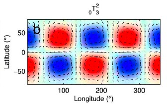
The global seismological mapping of the Earth’s interior (seismic tomography) provides us with increasingly detailed pictures of the present state of the Earth’s mantle. In order to sharpen images of the Earth’s interior, it is essential to explore the full richness of information in seismic data and to use accurate theoretical formalisms to model seismic waveforms at affordable computational cost. We use massive seismic datasets along with High Performance Computing (HPC) facilities to build global images of shear wave velocity and radial anisotropy in the Earth’s mantle (Ferreira et al, 2010; Chang et al., 2013). In addition, we use both purely numerical and asymptotic techniques to simulate seismic wave propagation in realistic media (e.g., Ferreira and Woodhouse, 2007a,b). We are currently exploring these techniques along with novel measurements of seismic wave amplitudes to build new global 3-D models of attenuation in the Earth’s mantle.
Regional Seismic Imaging/modeling
Complementary to global seismic tomography, regional seismic imaging and modelling provide focused and high-resolution analysis of the Earth’s interior and enable us to decipher physical/chemical processes that may be difficult to directly infer from large-scale imaging. Typically, we focus on observations and modelling of high frequency scattering and diffraction wave to achieve fine resolution at the scale of 1-10 kilometre.
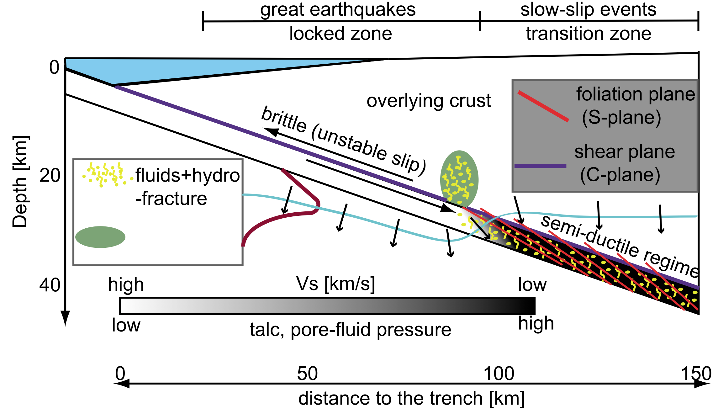
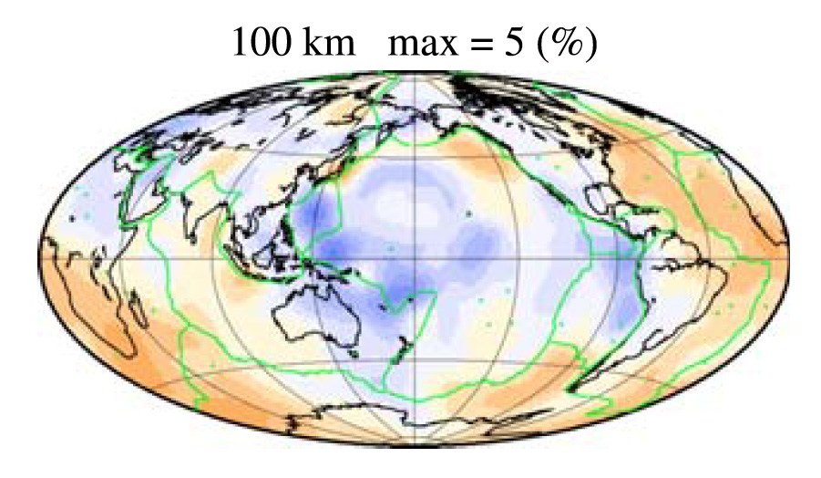
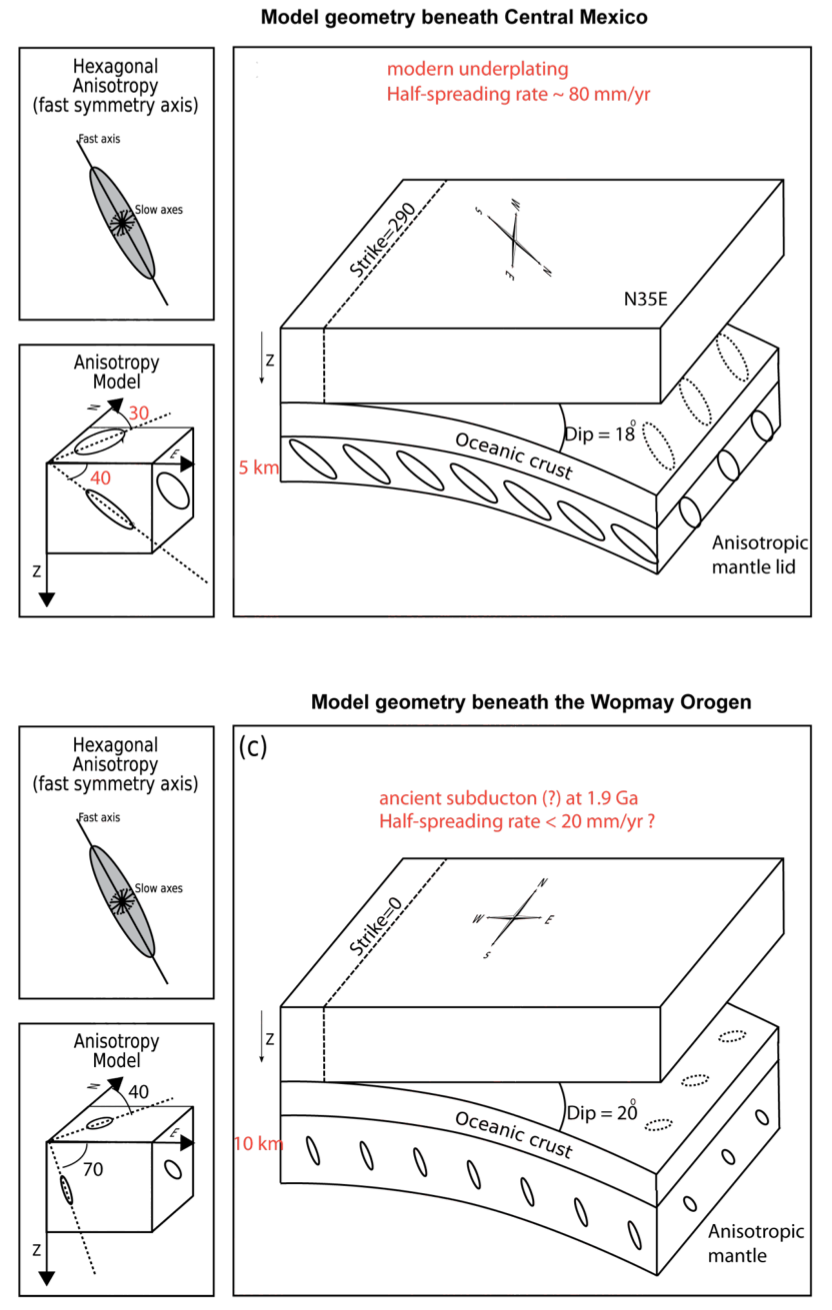
Our interest spans from material damage by great earthquakes (Yu et al., 2013a, 2013b), structural control of slow slip events in subduction zones (Song et al., 2009; Song and Kim, 2012b), the nature of asthenosphere anisotropy and subduction zone flow filed (Song and Kawakatsu, 2012; 2013), the lithosphere formation and destabilization (Song and Kim, 2012a; Song and Helmberger, 2007a,b,c), deep dehydration melting in the mantle transition zone (Song et al., 2004; 2006) and heterogeneity in the boundary layer of the lowermost mantle (Sun et al., 2006). Our focus currently extends to density contrast at the phase transition boundary in the mantle transition zone, as well as the intrinsic/extrinsic anisotropy within the interior of the oceanic lithosphere.
Kinematic faulting models
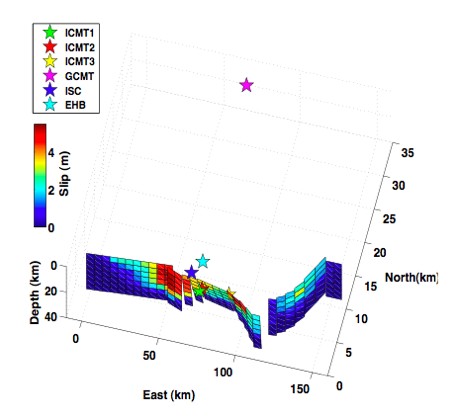
Seismic data are key to image the geometry and mechanism of earthquake source processes (Ma et al., 2000, 2003; Park et al., 2005; Chlieh et al., 2007; Konca et al, 2007). A wide range of rupture behaviors has been observed, from recently discovered silent slip events to faults that slide at supershear speeds. We test and build simple kinematic models of earthquake source processes using a wide range of techniques and seismic data – body waves (e.g., Vallee et al., 2011), surface waves (e.g., Ferreira et al., 2011) and low-frequency normal modes (e.g., Lentas et al., 2013). Since recently, we also use geodetic (InSAR) data (e.g., Weston et al., 2013), which is highly complementary to seismic observations, and we have built the ICMT database, the first archive of source models based on InSAR data (Weston et al, 2011, 2012).
Multidisciplinary geophysical data
While traditionally seismology uses mainly records from seismometers and thus exploits only the three spatial components of translational motion, a complete understanding of the seismic wavefield requires records of strain and rotational motions too. We have modelled tilt signals recorded by long-baseline fluid-tube tiltmeters (Ferreira et al., 2006) and we are currently extending this work to the analysis of high-quality strain data. Moreover, we are exploring exciting new records of rotation signals from ring-laser instruments within the new field of rotation seismology (e.g., Ferreira and Igel, 2009; Kurrle et al., 2010; Igel et al., 2011; Nader et al., 2012). Finally, we explore long-term control of great earthquake through investigation of earth’s gravity field in subduction zone fore-arcs (Song and Simons, 2003).
Experimental rock deformation and laboratory seismology
Geophysical observations provide an indirect tool to access to the Earth's structure and the dynamics of earthquakes. These observations are usefully complemented by laboratory experiments performed under pressure and temperature conditions similar to those found in the Earth's crust.
We perform rock deformation experiments while monitoring acoustic emissions, which is the ultrasonic noise produced by microcrack propagation in the rock, and is an analogue of microearthquakes. This laboratory-scale seismological setup allows us to determine the dynamics of crack growth during rock deformation, and to detect the premonitory activity occuring prior to the formation of a macroscopic fault in the rock.

We also use our ultrasonic sensor network to measure P and S wave speed evolution during rock deformation (e.g., Brantut et al., 2014); such measurements, performed under controlled conditions, can be used to interpret the origin of wavespeed changes within the Earth's crust.
Our experimental setup also allows measurements of rock permeability during deformation and changes in pressure and temperature. Permeability data from laboratory and naturally deformed rocks are used in numerical simulations of fluid flow during and after earthquakes (e.g., Brantut et al., 2010)
Quantitative field studies of earthquake faults
The damage zone surrounding faults is of key importance in controlling the mechanics of the faulting and earthquake processes (e.g. Mitchell & Faulkner, 2009, Griffith, Mitchell et al. 2012). This is because damaged rocks have very different physical properties than the surrounding rock, and so the damage zone directly affects the initiation of movement on pre-existing faults, the propagation of ruptures during earthquakes, and the radiation of seismic energy.
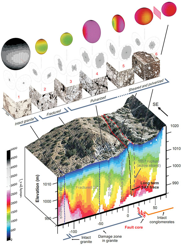
Combining quantitative field studies (e.g. Mitchell & Faulkner, 2009, Rempe et al, 2013,) with laboratory experiments (e,g, Mitchell & Faulkner, 2008) provides an important bridge between seismological source theory, rock and fracture mechanics, and the geological structure of natural fault zones (e.g. Griffith, Mitchell et al. 2012, Mitchell & Faulkner, 2012) which can allow improved predictions of earthquake rupture along fault, leading to an improved understanding of near-field ground motion and seismic hazard predictions.