Central Assyria, the lands between Assur, Nineveh and Arbela
Central Assyria was under the continuous rule of the Assyrian kings from the 14th to the 7th century BC. Unlike the regions west of the Tigris, which formed part of the Middle Assyrian kingdom but were lost to the newly forming Aramaean states in the 11th century BC, this area was not directly affected by the political and social changes of the late 2nd millennium BC. When Adad-nerari II (911-891 BC) and his successors undertook to restore Assyria's old borders, they did not need to re-establish control in this core region.
The Assur - Nineveh - Arbela triangle
The heartland of Assyria is demarcated by the city of Assur (modern Qala'at Sherqat) in the south, by Nineveh (modern Mosul with the ruin mounds Kuyunjik and Nebi Yunus) in the north and by Arbela (modern Erbil) in the east. As the crow flies, the distance between Assur and Arbela is c. 105 km, between Assur and Nineveh c. 100 km and between Arbela and Nineveh c. 80 km.
These three cities dominated northern Mesopotamia's cultural and political history throughout the second millennium BC. Already this emerges clearly from the Mari state correspondence of the 18th century BC when they were the capital (Assur) or the religious centres (Nineveh in Nurrugum and Arbela in Qabra) of independent kingdoms that were then briefly brought together in the short-lived empire created by Samsi-Addu of Ekallatum.
While most of the regions within the triangle formed by these three ancient cities are situated east of the Tigris, Assur lies on the western riverbank and thus provided access to, and control over, the important route leading in western direction to the Habur and Euphrates valleys. Situated on the fringes of the desert to the north of the artificially irrigated lands of Babylonia, Assur was a natural contact point with the pastoralists who made use of this arid region. Situated at the triangle's northern tip, Nineveh - like Assur - controlled an important ford across the Tigris but lay on the eastern riverbank. It was the natural destination of the overland route running along the southern foothills of the Taurus mountain range that leads to the Mediterranean coast and into Anatolia.
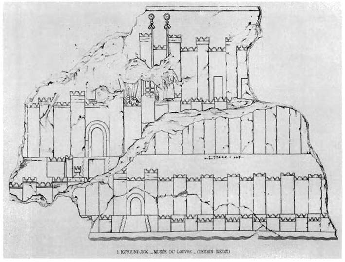
The triangle's eastern tip, Arbela, is located on the western fringes of the Zagros mountain range and controls the various routes across the mountains into Iran which take their departure from there. The city is also located on the important route that leads alongside the Zagros down to the Diyala river and into Babylonia, the key overland connection between central Assyria and the south. Unlike Assur and Nineveh with their long history of archaeological exploration, excavations in Arbela have started only very recently: a Czech team from the University of West Bohemia in Plzeň led by Karel Nováček has been excavating in Erbil since 2006 (read a first report [http://tinyurl.com/yjw27f7]). So far, the most evocative source for Arbela in the Neo-Assyrian period remains a depiction of the city on a wall relief from Assurbanipal's North Palace at Nineveh. Arbela is identified by name and the scene shows the city walls, the fortification walls of the acropolis and the temple of Ištar, whose entrance is marked by two high poles bearing the standard of the goddess.
The patron deities of Assyria
The Assur - Nineveh - Arbela triangle was the heartland of Assyria not only geographically and geopolitically but also culturally and ideologically. The main temples of the three cities were dedicated to the most important Assyrian deities: Aššur, the lord of Assyria whose earthly representative was the king, and the goddesses Ištar of Nineveh and Ištar of Arbela who were celebrated as patrons and protectors of Assyria.
As a praise poem composed in honour of the two goddesses and on behalf of king Assurbanipal (668-c. 630 BC) puts it:
"Exalt and glorify the Lady of Nineveh, magnify and praise the Lady of Arbela, who have no equal among the great gods! ... Not [with] my [own strength], not with the strength of my bow, but with the power [... and] strength of my goddesses, I made the lands disobedient to me submit to the yoke of Aššur. ... The Lady of Nineveh, the mother who bore me, endowed me with unparalleled kingship; the Lady of Arbela, my creator, ordered everlasting life (for me). They decreed as my fate to exercise dominion over all inhabited regions, and made their kings bow down at my feet." (SAA 3 3)
No Assyrian king could afford to ignore these gods, their shrines and their festivals. The relocation of Assyria's political and administrative centre away from Assur, where the dynasty of the Assyrian kings had its origins, first in 879 BC to Kalhu and then in 706 BC to Dur-Šarruken, was designed to neutralise the political power of all these cities by creating new patterns of authority and allegiance, both geographically and socially. But Assur, Nineveh and Arbela maintained their importance as religious centres and their gods and festivities continued to occupy a fair share of the king's time.
The central Assyrian provinces within the empire
Compared to the rest of the empire, the provinces of the Assyrian heartland were small in size. This reflected historical developments as the provinces in this oldest part of the state had been established at a much earlier time and survived, in most cases unchanged, sometimes merged with a neighbouring province into a bigger unit, from the Middle Assyrian period. But while the land controlled by these provinces was much more limited than that of the new provinces created in the 9th and especially in the 8th century BC, it was intensely developed agricultural land without any of the empty space occupied elsewhere in the empire by deserts or mountains.
However, by the reign of Sargon II (721-705 BC), the governorship over a central Assyrian province was no longer the pinnacle of a successful career in the state administration it had once been. It was now far more prestigious to govern one of the new provinces and the governorship over a central Assyrian province represented an earlier, more junior stage in an official's career. This is clear from the cursus honorum of individual state officials active under Sargon: Šep-Aššur, for instance, was first governor of Dur-Šarruken before being promoted to govern Ṣimirra on the Phoenician coast (SAA 1 124). Similarly, changes in the identity of those who held the title of year eponym TT reflect the fact that the more experienced governors now ruled over the newly annexed and distant provinces.

It made political sense to dispatch to postings far away from the court and the central administration, and therefore the Assyrian core region, only officials who had already proven their worth and their loyalty to the king. This strategy, however, automatically made governing a central Assyrian province less prestigious. It mirrored the more general shift in the attentions of the king and his administration away from the heartland, the almost unavoidable result of the rapid extension of the provincial system during the second half of the 8th century BC. Yet while the Assyrian heartland may have gradually lost in political significance, evidence such as Assurbanipal's praise hymn quoted above makes it absolutely clear that not only Nineveh, which was made capital by Sennacherib (704-681 BC), but also Assur and Arbela retained their cultic and ideological importance for and within the empire until the demise of the Assyrian state in the late 7th century BC.
Further reading:
Altaweel, 'The imperial landscape of Ashur', 2008.
Oates, 'Studies in the ancient history of Northern Iraq', 1968.
Radner, 'Provinz: Assyrien', 2006.
Radner, 'The Assur-Nineveh-Arbela triangle: Central Assyria in the Neo-Assyrian period', 2011.
Content last modified: 5 Nov 2012.
Karen Radner
Karen Radner, 'Central Assyria, the lands between Assur, Nineveh and Arbela', Assyrian empire builders, University College London, 2012 [http://www.ucl.ac.uk/sargon/essentials/countries/centralassyria/]