![]()
Registered Office
University College London, Institute of Archaeology, 31-34 Gordon Square, London
WC1H 0PY
NUMBER 55 APRIL 2007
(1Mb pdf file)
An Iron Age Decapitation From The Sculptorĺs Cave, Covesea, Northeast
Scotland
The Faunal Remains From Totty Pot, Somerset
Residue Analysis On Bell Beaker Ceramics From Hostice, Moravia
Mediterranean Bronze Found In English Waters
Developing The English Heritage Research Strategy For Prehistory
Conference News
Bronze Age Connections
The Bronze Age Forum 2006
The Prehistoric Society 2006
Statement Of Financial Activities For The Year Ended 31 December
2006
Biological Regionalism On Neolithic Cyprus
Interactions Across The Irish Sea: The Southern Kintyre Project
A Geophysical Survey Of Arminghall Henge, Norfolk
The Sixteenth Europa Lecture
 The entrance to the Sculptor's Cave |
The cave is not an easy place to get to at any time and is wholly inaccessible at high tide. As Sylvia Benton said, ôthe sun never touches itö, and its gloomy interior, although fairly spacious, seems an unlikely place for human occupation. Instead, it seems probable that the Sculptorĺs Cave retained a predominantly ritual function throughout its use.
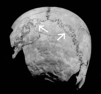
 vertebra HM-159, showing the cut-marks consistent with decapitation.")  Two views of human second cervical (axis) vertebra HM-159, showing the cut-marks consistent with decapitation. |
Until now, the entire human bone assemblage has been thought to date to the Late Bronze Age. The long history of human activity in the cave, however, along with the limited stratigraphic control available for the material from Bentonĺs excavations, suggested that scientific dating would be essential to understand the chronology of the assemblage.
Initial re-examination of the cervical vertebrae recovered from Bentonĺs excavations raised some doubts as to their date. The nature of the cut-marks on at least some of the vertebrae looked to have been made by sharp, heavy blades more suggestive of iron than bronze weaponry: in one case the entire vertebra has been cleanly sheared through horizontally in a single blow. This observation, however, is based simply on visual inspection of the cut surfaces; further examination using scanning electron microscropy is planned. An initial sample of bone from one of the cut-marked axis vertebrae (HM-159), submitted for AMS dating to the 14CHRONO Centre at Queenĺs University Belfast, provides more substantial support. This returned a result of 1738 ▒ 33 BP (UB-6930), which calibrates to AD 231-395 at 2 sigma, firmly within the Roman Iron Age.
Is it possible, then, that the human bones derive from at least two distinct episodes more than a millennium apart? Certainly the stratigraphic associations of certain human bones from the 1970s excavations, notably the juvenile mandibles, seem to suggest a Late Bronze Age date. Intriguingly, Professor Alexander Low, who examined the human remains from Sylvia Bentonĺs excavations before they were discarded, judged that there was a ôlarge proportion of bones of young individualsö. Despite this, however, all but one cut-marked cervical vertebrae are from adults (the bones of the cervical vertebrae fuse in early adulthood, between ages 17-25). Perhaps, then, we have two periods of deposition: a Late Bronze Age one in which the remains mainly of children were deposited in the cave, with some emphasis on the placing of heads at the entrance, and a Roman Iron Age episode represented by the remains of several decapitated individuals. Concern with the removal, curation and display of human heads is a persistent trait in prehistoric Europe, with a wide chronological and geographical distribution. It is not inconceivable that somewhat similar practices, involving the appropriation, manipulation and perhaps display of human heads may have happened twice in the Sculptorĺs Cave, separated by a millennium or more. The real picture may of course be much more complex and we cannot discount some form of continuity over the intervening centuries. A further programme of AMS dating and osteological analysis is now in preparation to clarify the full chronology and revisit the interpretation of this extraordinary site.
Ian Armit (University of Bradford) and Rick Schulting (University of Oxford).
The Faunal Remains From Totty Pot, Somerset
 Cut marks on a probable aurochs rib |
A selection of the animal bones was briefly examined by both Tony Oldham and I. M. Evans around the time of the excavation in the early 1960s and more recently by Andy Currant of the Natural History Museum. However, it was not until earlier this year that the full assemblage was formally identified. This analysis was undertaken at the Grahame Clark Laboratory for Zooarchaeology in Cambridge University and was supported by a grant from the Prehistoric Society.
A wide range of animals were identified and included aurochs, domestic cattle, wild and domestic pig, red deer, roe deer, horse, sheep/goat, fox, cat, dog, badger, weasel, hare and rabbit along with bones of small mammals, amphibians and birds. The microfauna were not examined in detail but included mole, common shrew, water, bank and field vole and red squirrel along with bones of amphibians and fragments of oyster shells. Amongst the small assemblage of bird bones, duck, corvid (crow-size) and woodcock were identified. Additional human bones (numbering 17) were also found mixed in amongst the faunal remains.
Few positive butchery marks were noted (just 1% of the quantified assemblage) but they included cut marks on two large, probable aurochs, ribs. No signs of burning were observed but gnawing marks, mainly of carnivores, were noted on a range of bones. The aurochs bones were all of mature animals (a minimum of two individuals were identified), which contrasts with the dominance of immature animals represented by the domestic cattle bone assemblage. The limited metrical data, when compared with the more extensive data on aurochs from Star Carr and Mesolithic Danish sites, suggests that one of the Totty Pot aurochs was female. Similar comparative metrical analyses for roe deer indicates that they were comparable in size with modern roe deer and are unlikely therefore to be early postglacial in date when roe deer were relatively large. There was a wide range of sizes represented by the pig, cat and fox bones with some of the latter, when compared with specimens held in the Natural History Museum, potentially from Arctic fox. With the possible exception of these few small fox bones, the overall the range of vertebrates from Totty Pot is of a Holocene rather that Pleistocene aspect and this corresponds with the two C14 dates and the artefactual record.
Further small excavations were conducted around the mouth of the swallet hole in 1998 by Paula Gardiner of Bristol University but few archaeological remains were found. These recent excavations, along with the 1960s investigations including a full report on the animal bones discussed briefly here, will be published early next year in the Proceedings of the University of Bristol Spelaeological Society.
Dr Emily Murray,
School of Geography, Archaeology and Palaeoecology,
Queenĺs University, Belfast, BT7 1NN,
email e.v.murray@qub.ac.uk
Residue Analysis On Bell Beaker Ceramics From HoÜtice, Moravia
")
Grave assemblage, burial 942 (copyright and reproduced withpermission of J. Turek)
Organic residue analysis investigates the presence and nature of lipids adhering to or absorbed into archaeological materials and has been able to provide information on prehistoric diets, material culture, vessel use and patterns of trade and exchange. The porous structure of prehistoric ceramics is particularly useful as it permits the migration of biomarkers from any contents and sealants into the matrix of the pottery. These residues can be retained over long periods of time, being traceable in their original form or as degradation products, although issues of contamination always require consideration. The results of a pilot study in which 19 sherds from 6 of the grave assemblages were sent to the University of Bradford for analysis by gas chromatography-mass spectrometry (GC-MS) were encouraging. Five sherds showed indications of fats from meat or vegetable sources and one definitive result, from a polypod bowl, demonstrated the presence of beeswax on its interior surface.

'Storage vessel' from burial 854
The acquisition of the samples, unfortunately, proved more problematic as almost all of the vessels from HoÜtice had been cleaned, removing any adhering soil and/or residues. They had also been reconstructed using copious amounts of adhesive and plaster creating considerable contamination. However, 17 sherds were acquired together with associated soil samples from 3 of the vessels, which have the potential to yield very valuable information. I also obtained samples of the adhesive and plaster used in the reconstructions in order to provide comparative data enabling me to assess the level and nature of the contamination and argue a case for archaeologically relevant results. Moreover, the opportunity to discuss the requirements of chemical analysis with Dr. Turek and Dr. MatejÝckovß of the Institute of Archaeological Heritage, Brno, proved very valuable as it was agreed that, in future, a single sherd would be retained from each vessel excavated before reconstruction and preserved in optimum conditions for residue analysis.
The visit was not all work, though; I also found time to tour the sights and shops of Prague, investigate the lovely second city of Brno, play petanque (badly), spend a morning excavating on a Bronze Age site, savour the joys of fieldwalking across the oppidum of Stradonice and spend a night at the renovated thirteenth century chateau of Nisbor sampling some fine Eastern European wine, food and hospitality. This opportunity has provided me with invaluable insights into many aspects of Czech history ancient and modern and created the first opportunity for an accurate study of ceramic use from the country through organic residue analysis. I am now far better equipped to write about the site and the period and hopefully the connections established will lead to many more such opportunities to further our knowledge of prehistoric vessel use in Eastern Europe.
Rhea Brettell,
Division of Archaeological, Geographical and Environmental Sciences,
University of Bradford
Mediterranean Bronze Found In English Waters
")
The strumento from the Salcombe Protected Wreck site (South WestMaritime Archaeological Group)
The recent licensed recovery of the material from the Salcombe Protected Wreck site by the South West Maritime Archaeological Group (SWMAG), supported by Bournemouth University, has included a rare strumento con immanicatura a cannone. This object is the first secure object of Mediterranean origin and Bronze Age date to be found in north-west Europe and dates from the Penard phase of the Bronze Age, circa thirteenth century BC.
However, despite its significance, archaeologists are still unclear what purpose the strumento served. The artefact is currently being assessed by the British Museum and the broader site is of considerable importance for understanding the nature of maritime contacts in Bronze Age Europe.
The National Heritage Act (2002) enabled English Heritage to assume responsibilities for maritime archaeological sites of all types from low water out to the 12 nautical mile territorial limit around England. The Act also allows the Secretary of State for Culture, Media, and Sport to direct English Heritage to also undertake functions relating to the Advisory Committee for Historic Wreck Sites and the archaeological diving contract. Accordingly, English Heritage has statutory responsibility for the physical management of historic wreck sites designated under the Protection of Wrecks Act 1973.
ôIt is estimated there are as many as 400,000 wrecks in the sea around England,ö says English Heritageĺs chief archaeological adviser, David Miles. ôIn addition, evidence of prehistoric landscapes lie beneath the North Sea and English Channel. This is an important and very exciting area of our work.ö
Further information on the Bronze Age assemblage is available from the South West Maritime Archaeological Groupĺs website: http://historyfromthesea.net/home.php
Mark Dunkley,
English Heritage
Developing The English Heritage Research Strategy For Prehistory

A good example of an innovative project delivering improved understanding, new techniques and training is the Northumberland and Durham Rock Art Recording project.
As with any such high-level document, implementation of the EH Research Agenda depends on a series of more detailed strategies. The aim of the Research Strategy for Prehistory, currently in development, is therefore primarily to guide EH research activities. But such activities also need to reflect the requirements and priorities of the wider archaeological community, so it is important to establish exactly what those are.
In part this is being done through ongoing consultation with a variety of experts, notably the Council of this Society. However, much of the groundwork already exists in the form of research frameworks. We now have national frameworks for the Iron Age and for the Palaeolithic and Mesolithic, while Regional Research Frameworks (RRFs) have been published for London, the Eastern Counties, the East Midlands and the North-East, with the other regions in progress. In one sense, trying to order prehistoric research may seem restrictive and even pointless: after all, the beauty of the subject is that we almost never know exactly what will be found. However, this rather misses the point of such documents. There will always be serendipitous discoveries and our frameworks need to be flexible enough to account for them. But when resources are limited, it is essential to ensure that we are clear about what we really need to know. Moreover, these documents serve a number of other useful purposes. They indicate where there is a real consensus across different regions and periods: an example is the often expressed need for better chronologies. They also have an important role in fostering a Ĺresearch cultureĺ outside academia, grounded in the practical needs of curators and contractors. They provide a rare forum for discussion between archaeologists in local authorities, units, universities and the amateur sector. And they serve to remind us of the value of less fashionable research, such as the interrogation of archives in museums or record centres. Finally, they help us look to the future - while we may not be able to predict individual discoveries, we can perhaps anticipate some of the issues that will increasingly affect prehistoric sites and landscapes, such as the impacts of climate change.
Beyond guiding EHĺs own work, what can the Research Strategy for Prehistory achieve on top of all these other documents? We hope that it will provide an opportunity to dig a little deeper into some of the issues that have been less clearly articulated. For instance, while the RRF process puts a strong emphasis on filling Ĺgaps in knowledgeĺ a complementary national strategy for England could also focus on the value of building more detailed understanding in relatively well-researched areas, or considering different interpretative approaches. The chronological structure of the RRFs could be complemented by a more thematic approach, looking across some of the conceptual boundaries that still constrain prehistoric research (and outreach). The apparently mundane business of populating the EH Research Agenda with prehistoric projects in fact offers a unique opportunity to gain an overview of the current state of research across England, and to help facilitate a discussion about where the future ought to take us. This is a consultative process when the strategy is launched later this year there will be a chance for everyone to comment and provide feedback. We hope the results will be of value well beyond English Heritage.
If you are interested in finding out more about the English Heritage Research Strategy for Prehistory please contact Jonathan Last, Head of Research Policy for Prehistory, English Heritage, Fort Cumberland, Eastney, Portsmouth, PO4 9LD or via email jonathan.last@english-heritage.org.uk
Conference News
IARSS 2007
Dept. of Archaeology, University of Southampton, May 30-31, 2007
Now in its tenth year, the Iron Age Research Student Seminar (IARSS) is designed to provide a relaxed environment for postgraduate students to present and discuss new research on the Late Bronze Age and Iron Age of Britain, Ireland and northwest Europe. Academics, professionals and undergraduates are also invited to attend to give support and comments. To mark the tenth anniversary, no registration charge will be made for this yearĺs seminar. To register, please email mlally@soton.ac.uk or jjoy@thebritishmuseum.ac.uk by 1 May. If you would like to present a paper or poster, please send your proposed title and a 250 word abstract to either of the email addresses above by 20 April.
Bronze Age Connections
The theme this time was Bronze Age connections: cultural contact in prehistoric Europe and given this title it was fitting that the grand old man of Bronze Age connections, Jay Butler, was among nearly two hundred delegates. A distinguished list of speakers included the Secretary General of the International Union of Prehistoric and Protohistoric Sciences, a Knight of the Realm and the Editor of this newsletter. The venue was appropriately sited a little way out into the Channel on the western quay of Dover Harbour in one of Dover Harbour Boardĺs cruise terminals, which provided more salubrious facilities than usual. Frank Panton and his colleagues in the Trust are to be congratulated on this and other aspects of the organisation of the conference, whose proceedings will be published.
We heard about the Ringlemere cup from Stuart Needham in a lecture delivered shortly before his retirement from the British Museum. He described the group of cups of various precious materials whose use probably represented a ritual aspect of contact among different cultural groups in England and on the continent, perhaps involved in the supply of amber to Wessex and Brittany at about the time of the Dover and Ferriby boats. Stuart coined a new concept - a ĹMaritoryĺ - for the marine area between these Transmanche communities. The publication of the cup (reviewed on the Societyĺs website) appeared on the first day of the conference.
Apart from Ringlemere, the highlight for your correspondent was a subtle interpretation by David Fontijn of the bronzes imported into the Netherlands during the Earlier Bronze Age. In particular, he proposed that material from Britain was not imported directly but came via northern France and when it had reached the southern Netherlands was no longer recognised as British but simply as exotic. Another aspect of Dutch prehistory was deconstructed by Liesbeth Theunissen who showed that the Hilversum culture was not the result of immigration from Britain. Her paper was distinguished by full reference to the characters of the archaeologists involved in the conception of the Hilversum culture.
Jean Bourgeois and Marc Talon described contrasts and similarities between the apparently homogeneous regions of Flanders and Picardy, while Michel Philippe spoke about the significance of the estuary of the River Canche for cross-Channel contact from the Bronze Age to early medieval times.
Two speakers brought inanimate objects to life in different ways. Mary Helms presented the project manager of the Dover Boat as a Ĺmaster of hard materialsĺ, in charge of both practical and ritual aspects of the vesselĺs construction. Jo BrŘck saw objects from burials as gifts from the living rather than possessions of the dead and concluded that there were no elites in the British Bronze Age. Elites were, however, flourishing elsewhere, notably at Amesbury whence the Archer made his latest appearance in the form of his alter ego Andrew Fitzpatrick.
The Iron Age was represented by Sir Barry Cunliffe, who added to his distinctions when he accepted the position of Honorary President of the Dover Boat Trust before his talk on maritime contacts in the later first millennium.
Some of the subjects were rather predictable, to the exclusion of others perhaps more relevant to the theme of the conference. Langdon Bay was mentioned briefly in several papers but might have merited a full presentation. The gold hoards from Balinghem and Guines - the latter with an extraordinary triple torc - only about 50km from Dover across the Channel, appeared on maps but were never even illustrated. We heard little about the extensive Bronze Age settlement sites recently excavated in Normandy and virtually nothing about settlements or pottery from Kent. These would all be good subjects for the Trustĺs next conference as part of its continuing remit to foster academic and public understanding of the Bronze Age.
The Trust has triumphantly achieved its initial objective of conserving and displaying the Dover boat but is not sitting on its laurels. Peter Clark announced ambitious plans, to be launched in March 2007, for experimental research on the Dover boat, including construction of half-scale and full-scale replicas and leading to a Channel crossing.
Brendan OĺConnor
The Bronze Age Forum 2006
The most recent gathering of the Bronze Age Forum, held at University College Dublin in November 2006, attracted a vibrant, international audience of over 100 researchers from museums, county councils, excavation units, heritage bodies and universities, as well as at least one artist. The impressive turnout of graduates and undergraduates from UCD itself was also notable. Similar diversity was apparent in the array of well-presented papers given over the course of the two-day meeting, which broached a broad range of topics, operating at a number of different scales, and drawing on a variety of interpretative approaches. While the vast majority of papers focused on the Bronze Age archaeology of Britain and Ireland, it was refreshing to hear contributions on material from the Dutch central river area, Brittany, the Iberian Peninsula and on Western Europe more broadly.
The weekendĺs events got off to an excellent start with a reception held in the impressive surroundings of the National Museum of Ireland, whose ambience was further enhanced by the unusually large wine glasses and tasty canapÚs! This was followed by an engaging keynote speech by Professor Barry Raftery, who managed admirably to Ĺcontrolĺ his enthusiasm and outline the remarkable evidence from the Later Bronze Age hillfort at Rathgall, Co. Wicklow, within the allotted 50 minute slot, rather than the 5 hours he claimed he could devote to it! The audience was treated to an alluring display of images from this extraordinarily rich site, and were clearly enthused by the experience. The subsequent discussion considered topics as wide-ranging as the logistics of procuring materials for the mercury-guilded gold item from the site, to the question of exactly what kind of occupation this wealth of evidence might represent.
The opening sessions of the conference itself concentrated primarily on Irish settlement-related material, including papers that considered new architectural forms, connections between human and artefact biographies, long-term changes in agricultural strategies, and the ubiquitous, yet enigmatic, phenomena of burnt mounds. Some strong themes which emerged were not only the wide variety of settlement activity across Ireland for this period, but also the development of regionally specific settlement practices. This is perhaps testimony to the recent abundance of excavations in Ireland, at least in part enhanced by developer-led work. The latter was also seen as a facilitating factor in a paper by Stijn Arnoldsson (University of Leiden), who used recent material from well-preserved Middle Bronze Age settlements in the Dutch central river area to critique traditional models of domestic mobility for this period.
An entertaining afternoon session brought together a series of papers on the spectacular findings of recent re-analyses of Beaker/Early Bronze Age burial assemblages in Britain (or Bronze Age Ĺblingĺ as it was aptly described). Studies examining the pre-depositional histories of items from wealthy graves of this period highlighted the potential of analyses using microscopic, XRF and chemical techniques to open up new topics for research. Thus Alison Sheridan (National Museum of Scotland) revealed that a spacer plate necklace from Inchmarnock was made from beads of jet-like materials from various sources, possibly representing recycled fragments from five distinct necklaces. Wear and fragmentation studies were also used by Ann Woodward (Birmingham University) to assess the incidence of curated objects ľ relics and heirlooms ľ in such contexts. Meanwhile, insular conceptions of early and late ĹWessex Cultureĺ burials were probed in papers by Stuart Needham (British Museum) and Paul Garwood (Birmingham University), both of whom highlighted the diverse sources from which the materials found in such contexts were derived. Thus, it was argued, these highly unusual burial practices must be understood in relation to wider regional trends and routes of interaction across Britain and beyond.
On Sunday, the attention turned to new discoveries in Ireland, with papers exploring the potential of gas pipeline projects to investigate Bronze Age landscapes, the precise chronology of Irish Bronze Age pottery, and some intriguing Early and Middle Bronze Age burials from developer-funded excavations. Later, Richard Bradley (Reading University) celebrated his sixtieth birthday with an entertaining paper on recent findings from the excavation of a monument complex at Broomend of Crichie, Aberdeenshire, and, along with John O NÚill (UCD), questioned previous classifications, chronologies and interpretations relating to Bronze Age megalithic monuments in Scotland and Ireland. Metalwork formed the focus of the final two sessions, which incorporated some thoughtful papers and traversed a diversity of scales. Thus, while a presentation by Kate Waddington (Cardiff University) considered the potentially powerful, sensuous and enchanting qualities of four miniature axeheads from a Later Bronze Age midden at Whitchurch, Warwickshire, another by Ben Roberts (Cambridge University) forefronted the role of prehistoric communities ľ the choices, constraints and practices involved in creating, circulating, using and depositing metal objects ľ in a study reconsidering the transmission of metal objects and metallurgical expertise across Europe.
Overall, thanks to the organisational teamwork of Katherina Becker, Joanna BrŘck and John O NÚill, the Bronze Age Forum was a pleasure to attend ľ both stimulating and enjoyable.
Anwen Cooper, Department of Archaeology, University of Reading
The Prehistoric Society 2006
This report covers the period January to December 2006
Meetings and Study Tours
The 2006 UK Study Tour in June was to the rich archaeological landscapes of Caithness
and Sutherland. This was a very successful trip expertly organised by Emma Sanderson
with expert aid from Graeme Smith, Meg Sinclair, John Barber, Andrew Heald, Kenny
Brophy, Isla McCleod, Alastair MacDonald, Raymond Lamb, Strat Halliday, Paul Humphreys,
Noel Fojut, Jonathan Clark and George Watson. There was no overseas study tour this
year, however the increasingly popular student study tour in April was to ĹHidden
Wessexĺ. Thanks are extended to Julie Gardiner, Mike Allen, Bob Bewley, Dave McOmish
and Frances Healy for making this so successful.
Prehistoric Society events over the past year have been held across most of Britain The January lecture in association with the Devon Archaeological Society, welcomed Professor Anthony Harding talking about his research into Bronze Age warfare. A one-day conference in London looked at the effect large-scale excavations were having on our understanding of Prehistory and a second conference in March in Cardiff, entitled Land and People, focused on environmental archaeology was a tribute to, and celebration of, the work of the late Professor John Evans. Farming, Fields and Settlement was the theme of the Dillington House weekend in May. The Sixth Sara Champion lecture in September was by our PAST editor Dr Joanna BrŘck and entitled ĹLandscape, Politics and Colonial Identities: Sir Richard Colt Hoareĺs Tour of Ireland, 1806ĺ.
In October, a joint conference entitled Breaking the Mould: challenging the past through pottery was held jointly with the Prehistoric Ceramics Research Group at the University of Manchester and in November a second day conference, held jointly with the Dept. of Archaeological Sciences, University of Bradford focussed on Gristhorpe Man: A 21st century investigation of a 19th century discovery - a fresh study of this Bronze Age coffin burial. Also in November, an evening lecture by Duncan Garrow on the phenomena of Neolithic pits and settlement in East Anglia was hosted with the Cambridge Antiquarian Society in Cambridge. These lectures and conferences outside London demonstrate The Societyĺs commitment to reach wide regional audiences.
Europa Prize
On 24th May, after the AGM, the 15th Europa Prize was awarded to Professor Francisco
Marco (University of Zaragoza, Spain) who delivered a lecture entitled Images of
Transit: Ways of Death in Celtic Hispania and focused on the rich iconography of
Iron Age Iberia.
Research Grants
Grants totalling ú3620 were made towards Prehistoric Research. The Bob Smith Award
was presented to G. Robinson. The Leslie Grinsell Prize was awarded as no application
met with Grinsellĺs research interests.
The John & Bryony Coles Award
The Coles Award had been presented to R Brettell (University of Bradford) to visit
and sample ceramics from the Beaker cemetery at Hostice, Czech Republic and to R.
Lanehart (University of South Florida) for a study into residue analysis of Chinese
Neolithic ceramics.
Annual General Meeting 2005
The AGM was held on 24th May at the Society of Antiquaries of London at which, unfortunately
our President, Professor Miranda Aldhouse-Green had to resign for personal reasons.
Our Conservation Co-ordinator, Professor M Parker Pearson also offered his resignation
due to pressure of work. The meeting was instead expertly chaired by one of our
Vice-Presidents, Dr Frances Healy. The following officers and members of council
were elected:
| Vice-president | Prof Mike Parker Pearson |
| Hon Sec | Dr Alex Gibson |
| Hon Treasurer | Mr Alastair Ainsworth |
| Hon Editor | Dr Julie Gardiner |
| Meetings Secretary | Hon Mr D McOmish |
| Council Members |
Dr Chantal Conneller, Dr Mike Hamilton, Dr Kenny Brophy, Dr Alistair Barclay, Mr Paul Garwood |
The Baguley Award
The Baguley Award was presented by Dr Gardiner to Dr S Needham for his paper Transforming
Beaker Culture in North-West Europe: Processes of Fusion and Fission in vol 71 of
the Proceedings Membership Membership remains healthy and stable.
Membership
Membership remains healthy and stable.
Statement Of Financial Activities For The Year Ended 31 December 2006
| 2006 | 2007 | |
| ú | ú | |
| Incoming resources | ||
| From generated funds: | ||
| Voluntary income | 50,418 | 54,613 |
| Investment income | 10,143 | 11,257 |
| 60,561 | 65,870 | |
| From charitable activities: | ||
| Publication grants | 12,423 | 5,935 |
| Copyright fees | 1,170 | 956 |
| Merchandise | 186 | 191 |
| Advertising in publications | 250 | 950 |
| Back numbers of Proceedings | 2,021 | 2,222 |
| Conferences | 970 | - |
| Study tours | 11,934 | 12,050 |
| 28,954 | 22,304 | |
| Total incoming resources | 89,515 | 88,174 |
| Resources expended | ||
| Costs of generating | ||
| voluntary income | 7,347 | 7,612 |
| Charitable activities: | ||
| Grants | 4,231 | 4,237 |
| Lectures | 3,891 | 3,669 |
| Proceedings | 47,343 | 51,124 |
| PAST | 10,963 | 10,921 |
| Back numbers of Proceedings | 1,608 | 1,818 |
| Conferences | 1,545 | 501 |
| Study tours | 12,564 | 11,239 |
| 82,145 | 83,509 | |
| Governance costs | 4,247 | 4,865 |
| Total resources expended | 93,739 | 95,986 |
| Net (outgoing) resources | (4,224) | (7,812) |
| Total funds at 1 January | 174,811 | 178,329 |
| Net (outgoing) resources | (4,224) | (7,812) |
| Revaluation of investments | (6,832) | (4,294) |
| Total funds at 31 December | 163,755 | 174,811 |
The Statement of Financial Activities is an extract from the full accounts of the Society. Copies of the full accounts for 2006 can be obtained from Tessa Machling at the registered office.
Report of the Treasurer
The 2006 Statement of Financial Activities has been prepared in the new format specified
by the Charity Commission. The Society had an operating deficit of ú4,224 in 2006
compared to a deficit of ú7,812 in 2005. Incoming resources in 2006 were slightly
above the previous year due to a significant increase in publication grants received
for papers in PPS 72 offset by lower subscription income. As explained in previous
reports the level of grant aid for papers in PPS fluctuates between years depending
on the mix of developer funded and academic research papers in the journal. Subscription
income also fluctuates between years because of the timing of receipts from overseas
institutions. Resources expended were lower in 2006 compared to 2005 when the Society
had incurred the additional cost of producing two indexes of PPS papers. The Societyĺs
investments are held mainly in fixed interest funds and the valuation of these funds
decreases in relation to increases in the UK Bank Rate.
Biological Regionalism On Neolithic Cyprus
Human skeletal remains of approximately sixty individuals were studied and standard anthropological data was collected from the human remains including minimum number of individuals, age at death, sex of individuals, stature and dental non-metric traits. The data from the dental non-metric traits was used to determine the biological affinities of the ancient Cypriots. The human remains came from the Neolithic sites of Kissonerga-Mylouthkia located at the Paphos Museum, Kalavasos-Tenta at the Larnaca District Museum, Sotira-Teppes at the Limassol District Museum, Agios Savvas tis Karonis Monasteri and the Chalcolithic site of Choletria Ortos, both at the Kouklia Archaeological Museum in the Paphos District. These sites range in time from the Neolithic (c.7300 BC) to the Chalcolithic (c.3000 BC) and are located in the west, south and east parts of the island. Most of the remains come from burials, but the bones from Kissonerga-Mylouthkia come from refuse inside one the oldest wells found on Cyprus.
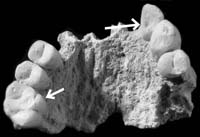
Non-metric traits are genetically determined and can be used to assess biological affinities (or biological composition) between groups. For this research, teeth were examined. They are particularly useful to study because they are made of enamel and dentine, which are more durable than bone, and have a greater chance of surviving in the archaeological record. Most dental non-metric traits occur as a pit, groove or even extra cusps or roots. Recording these traits does not require any special tools but does require training in identification. An example of some of the dental non-metric traits identified from the site of Agios Savvas is shown above. The photograph shows the maxilla with a number of teeth. The first molar has a Carabelli cusp trait and the second incisor shows the shovelling trait.
Early results indicate a total of 24 different dental non-metric traits. The number of traits per site ranged from 9 to 16. This suggests the biological affinities of the Neolithic Cypriots were local in character. In other words, since the most traits present at one site is only 16 this suggests the inhabitants were selecting mates closer to where they live. In addition, some traits are present only in certain parts of the island, suggesting local regionalism during the Neolithic. Even though Cyprus is a relatively small island it is unclear whether geographical or cultural barriers caused this regionalism. Although the samples this data are based on are small, it still shows a healthy gene pool for the Cypriot Neolithic.
An important idea this research raises is that the total number of traits on Cyprus may be an indication of immigrants from more than one area of the mainland and possibly at different times. If the Neolithic Cypriots are from different parts of the mainland this may explain the basis for the regionalism identified on the island that was then carried through to the Chalcolithic.
Acknowledgements
I am grateful to the Prehistoric Society for supporting this research through the
Research Fund award. I also wish to thank Dr. John Robb, University of Cambridge,
for his letter on my behalf. Special thanks goes to the director of the Department
of Antiquities of Cyprus, Pavlos Florentzos, for his permission to allow access
to the various skeletal collections last summer.
Dr Zissis Parras,
Anthropology Department, Wilfrid Laurier University, Canada.
Email: zparras@hotmail.com
Interactions Across The Irish Sea: The Southern Kintyre Project

The location of the walked fields around Southend, with some of the artefacts found. Top left: leaf-shaped arrowhead from Brunerican; Middle top left: barbed and tanged arrowhead from Brunerican. Middle top right: part of a leaf-shaped arrowhead from Coledrain; Top right: barbed and tanged arrowhead from Langholm. Bottom left: knife from Brunerican. Bottom right: part of a polished stone axe from Macharioch.
The Southern Kintyre Project was designed in order to gain a fuller understanding of interactions across the Irish Sea. Kintyre, just 12 miles from Ireland, provides the perfect study area for investigating questions about the occurrence, and nature, of interactions. Furthermore, while other areas of western Scotland have been the focus of archaeological investigation in recent years (for example Islay and Arran), very little work has been conducted in Kintyre beyond the excavation of known sites (chambered tombs) and the petrological analysis of the stone axes from the area. We have therefore proposed a five year project which looks at the early prehistory of southern Kintyre, in order to better understand the archaeology of the area and assess Kintyreĺs role in early interactions across the Irish Sea. Our study area for this project incorporates Campbeltown to the north and Southend in the south, with three key areas that we are targeting in more detail: 1. The area around the chambered tomb and hill of Blasthill close to Southend. 2. The raised beach around Campbeltown. 3. Davaar Island in Campbeltown Loch. These three areas comprise predominantly agricultural land, which offers great potential for fieldwalking, and all have great archaeological potential in terms of addressing interactions across the Irish Sea.
In April and September 2006 we undertook a programme of fieldwalking, together with a small-scale excavation. In the two 2006 seasons 20 fields were walked, mostly around Southend, but also a few near Campbeltown and south of Peninver, and some exciting finds recovered. Around Southend we found part of a leaf-shaped arrowhead as well as scrapers at Coledrain and a quantity of Neolithic scrapers at Macharioch. A field at Brunerican produced the most artefacts: a leaf-shaped arrowhead, a barbed and tanged arrowhead, two knives, cores and scrapers. This site was almost certainly the remains of a short-term settlement camp, visited in both the early and late Neolithic. At Langholm we found a barbed and tanged arrowhead, a piercer, two scrapers and a knife, all made from exotic non-local flint. More scrapers were found in the fields at Smerby further north near Peninver.

Fieldwalking at high Smerby
We also opened a small trench, measuring 8m x 3m, within which we found a large quantity of flint debitage (500+ pieces). Underneath the plough soil we found the remains of an ephemeral structure, which may once have held posts or a palisade. This is probably not Mesolithic in date, and may be the remains of a Neolithic structure of some kind. Unfortunately no dateable material was found in association with the structure so if we are to date it we would need to excavate the remainder. We are still analysing the flint from the site, which may also provide more clues as to the date of the structure.
So far we have collected evidence that is beginning to paint a picture of prehistoric activity in Kintyre. We already have some evidence for Irish objects, and we plan more work to assess the origins of the flint in our assemblages. All of this will contribute to a better understanding of interactions between Kintyre and Ireland from the Mesolithic to the Bronze Age. We will be returning to Kintyre in 2007 to conduct more archaeological work. All of our results are available online on our website: www.uclan.ac.uk/kintyreonline.
Vicki Cummings (University of Central Lancashire) and Gary Robinson (University of Wales, Bangor)
Acknowledgements
We are grateful to the Prehistoric Society for supporting this project through the
award of a research grant.
A Geophysical Survey Of Arminghall Henge, Norfolk
Arminghall Henge (Scheduled Ancient Monument Number: NF213) is situated less than 4km south of the centre of Norwich, in a pasture field, Bridge Meadow, and appears as an inconspicuous ripple in the terrain. It lies at the Yare-Tas confluence, in a natural basin on low-lying, yet flood-free gravel. Relative elevations do not exceed 40m. Although ploughing has caused some Ĺflatteningĺ, it is unlikely that the topography would have been vastly different in the past. The henge was probably the focus for a barrow cemetery during the Late Neolithic and Early Bronze Age. Arminghall Henge is one of Norfolkĺs most famous Late Neolithic field monuments and is frequently cited as being of great importance, yet specific questions about it remain unanswered and many even unasked.
")
Fig. 1 Arminghall Henge, looking north (copyright Norfolk Museums and Archaeology Service and photo by Derek Edwards)
A single radiocarbon assay was taken by the British Museum in the early 1960s, from oak charcoal excavated by Clark, from one of the post-holes. This produced a date of 3529-2740 cal. BC (4440▒150BP BM-129). Numerous archaeologists have written about Arminghall Henge, in the context of syntheses on henges and timber circles, the Neolithic period and local studies. Their Ĺfactsĺ have come largely from Clarkĺs report into his limited excavations, with little or no critical analysis of the evidence. The radiocarbon date is frequently referred to and despite doubts about its accuracy it is often accepted as proof of the antiquity of the monument. There is a serious lack of questioning approaches to this site, which results in us knowing very little about it.
As no geophysical survey had previously been performed here, the objective was to see if we could gain an increased understanding using a non-intrusive technique. Ideally, for the type of data I hoped to obtain, a magnetometry survey would have been most suitable, but pylons and overhead cables made this impractical. Instead, I performed an earth resistance survey, covering 0.8 hectares in Bridge Meadow and 0.08 hectares in a neighbouring garden. I hoped this would be helpful in addressing unanswered questions:
- What was the nature of the outer ditch?
- Was it broken by causeways?
- Were there any other internal features of the monument?
- Could we learn more about the appearance of the bank?
- Was there an avenue?
- Are there other, potentially related, anomalies to be found?
Results from the garden show some indistinct anomalies, but those from Bridge Meadow are explained below (Fig. 2).

Fig. 2 Composite of the resistance survey results from Bridge Meadow. Letters refer to features mentioned in the text. Inset: Clarkĺs plan showing his trenches, overlain onto the geophysics
")
Fig. 3 Archaeology at the Yare-Tas confluence (based on OrdnanceSurvey and Norfolk HER data)
With regard to the character and extent of the bank itself, the results probably do not reveal anything new. On initial examination, it may be possible to see a narrowing of the bank (L) on the southern side of the henge, but interference from the pylon makes this impossible to confirm. Looking outside of the henge area, there is a dark line of high resistance readings which meet the present footpath. These may represent a natural geological feature or an area of compacted ground.
Although geophysical survey has shown great potential in increasing our knowledge about Arminghall Henge, we need to know far more about the role of such a significant monument in its landscape. I am currently undertaking research to place it in context, investigating the importance of both natural features and material remains. Of particular interest is Chapel Hill, on which the causeway of the henge aligns. The connection of the henge to this particular network of rivers is of great interest. I have also begun to look at the Early Neolithic archaeology of the Wensum and Yare valleys and connections with the coast, preceding the first known phase of construction at Arminghall. Further geophysics in the area may also enhance our understanding of this nationally known, but poorly understood, beacon of Neolithic Norfolk. How many of our Ĺfamousĺ monuments are suffering the same predicament as Arminghall Henge, with Ĺfactsĺ printed repeatedly, showing little or no emphasis on questions, uncertainties or what remains unknown?
Katharine Walker,
Cardiff University.
Email: kw3934@hotmail.com
Acknowledgements
I would like to thank everyone who has contributed something to this work, especially
Trevor Ashwin for reading and making detailed comments on a draft of the paper.
Thanks also to Rik Hoggett and Ĺthe geophys teamĺ, and to Norfolk Museums and Archaeology
Service.
The Sixteenth Europa Lecture

Prof. Lars Larsson
Professor Larsson is best known for his diverse and prolific record of research and publication on the Mesolithic and Neolithic of southern Scandinavia.
His field projects have made major contributions to our knowledge of such topics as Mesolithic settlement patterns and mortuary practices (he directed the excavations at the famous Mesolithic cemeteries of Skateholm), as well as our understanding of Neolithic landscapes, monuments and ritual. He has also carried out research on the Neolithic of Portugal and the Middle Stone Age in Zimbabwe, while his recent excavations at the settlement at Uppňkra examines the structure of Iron Age society in southern Sweden. He has published some 240 books and articles and is a member of numerous learned institutions, including the Royal Academy of Sciences, Stockholm.