![]()
Registered Office
University College London, Institute of Archaeology, 31-34 Gordon Square, London
WC1H 0PY
NUMBER 53 JULY 2006
(1.2Mb pdf file)
Codford Circle: Iron Age Pits and Feasting
Geheimnisvolle Kreisgräben: An Exhibition On Neolithic Enclosures
At Heldenberg, Vienna
Pools, Glowing Coals And Mud Volcanoes In Bulgarian Prehistory
Society News
The Europa Lecture 2006
Conference News
Land And People: Conference In Honour Of John Evans
Intriguing Discoveries At Ballybrowney, County Cork
The Prehistoric Society Uk Study Tour, 2006
Hidden Wessex: What You Don’t See From The Road
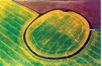 Oblique aerial photograph of Codford Circle (2001) from the south-east (© English Heritage). The approximate position of the main excavation trenches (slightly exaggerated for clarity) are shown in grey. |
Despite numerous notable antiquarians living and working within this area (Sir Richard Colt Hoare at Stourhead, Mr William Cunnington at Heytesbury and Mr Aylwn Lambert at Boyton), all of whom visited Codford Circle, no archaeological fieldwork is recorded. Nor have recent surveys, hillfort studies or other research paid it any attention. It falls just outside the Salisbury Plain Training Area and thus avoided inclusion in the excellent exposé of this prehistoric landscape by David McOmish, David Field and Graham Brown (see review on our website August 2005).
This rather simple, unremarkable monument has received little attention since 1804, and it would have remained so had it not been for a large black and white OS aerial photograph (c. 1978) in private hands that was put on display during a local village archaeological day. The enclosure, ploughed on the interior and up to its grassy bank on the exterior, showed up clearly, but more significant was a series of remarkable and previously unrecorded clear soil marks indicating an interrupted, possible oval circuit of pits and/or ditch segments inside Codford Circle, and another arc of pits outside the south-east entrance. Internally these constituted two arcs, one to the north-west and the other to the south-east, complemented by a third exterior arc of pits outside the south-east entrance. This inner enclosure and possible outwork had never previously been noticed or recorded.
These pit arcs were reminiscent of Early Neolithic causewayed enclosures or Later Neolithic henges. A possible causewayed enclosure is known at Scatchbury (c. 15km further down the valley), and henges are known in the vicinity; one lies in the Wylye Valley floor (Sutton Veny) and another possible example is located on the downland (near Upton Lovell).
Small-scale excavations were conducted to examine the nature of the hilltop enclosure, and to find and examine a length of the apparent interrupted inner circuit.
The enclosure
Excavation of the low (0.4m high) bank and entirely plough-infilled external ditch
revealed a steep almost V-shaped ditch 4m wide and 2.1m deep, lying below a natural
bluff upon which the surviving bank sealed a thick (0.3m) buried soil. Although
plenty of worked flint and animal bone were recovered, there was very little pottery
and, although undiagnostic, this was probably Iron Age. The form of the ditch was
unlike a Later Bronze Age hilltop enclosure and more in keeping with the supposition
that this was indeed an Iron Age ‘hillfort’. Only one entrance is known, in the
south-east, presently used by the farmer, and which has been considered to be modern.
However, survey by English Heritage conducted by David Field (with volunteers from
the Codford Local History Society) showed this to be the only clear interruption
of the bank circuit, although there are hints of a second entrance on the northwestern
side. Unlike at the south-eastern entrance, the infilled ditch is just visible and
continuous around the rest of the circuit. Inside the northwestern portion of the
bank, where the OS aerial photograph appeared to show an interrupted ditch or pits,
the survey revealed an internal length of shallow remnant ditch.
Pits
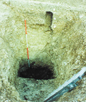 The pit under excavation. |
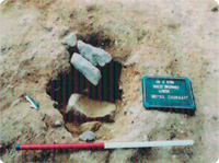
A 15m long trench was stripped crossing the feature found by augering. This targeted excavation revealed the top of a large oval pit (3.6m x 2.4m) filled with a typical ploughwash with burnt and worked flint. Below this was 1.2m of chalk rubble containing many worked flints and animal bones, some pottery and at least two large chalk loomweights. This backfilled chalk sealed a 0.4m deep greasy black and highly organic charcoal-rich deposit containing large quantities of crudely worked and burnt flint, animal bones (especially burnt ribs) and sherds of Early Iron Age pottery. On the base of the shaft-like pit, at a depth of 2.5m, were several placed burnt sarsen boulders. Excavation within the opposite side of the enclosure (on the line of the slight ditch surveyed by David Field) revealed the top of another comparable pit or ditch terminal which was not fully excavated due to time constraints. Nevertheless, the same sequence of flint-filled upper ploughwash over chalk rubble was present.
So, contrary to original expectations, this was a typically Iron Age enclosure, but there was nothing typical about the internal feature or its fill.
Feasting and fire
This evidence seems to have no parallel on the chalk of southern England, and if
the single excavated example is representative, it indicates a series of at least
34 pits in addition to longer ditch segments.
The basal deposit of the pit seems to represent the discard of one or more large Iron Age ‘barbecues’ at which beef and lamb ribs seem to have been an important constituent. Feasting may not be unknown in the Early Iron Age, but the disposal of the waste in 2.5m deep pits apparently excavated for this discard and then rapidly backfilled is unusual to say the least. Although the chalk rubble contained artefacts it was essentially very clean, certainly in stark contrast with the artefact rich black ‘barbecue deposit’. This seems to imply a deliberate sequence of events that included the digging of at a least one large pit, the dumping of food-related waste and its deliberate sealing with clean chalk backfill. Whether such activity took place during normal settlement practices or represents more ritualistic and ceremonial feasting event(s) we cannot say. However, while we may suggest ritual feasting and other sacred activities, a cautionary note was clearly presented by one of the present day uses of the site. The conspicuous hilltop earthwork provides an obvious rendezvous point. One regular meeting is of that of the local shoot, which often concludes in a congregation in Codford Circle around a permanently installed trestle table. Here the keen fieldworker can find plenty of evidence of conspicuous consumption and the imbibing of ‘ceremonial’ beverages, in the form of burnt animal bones, corks and discarded wine bottles - evidence that only survives for a few days before it is ‘ceremoniously’ removed and discarded elsewhere, to reside in a local community midden! Here is another clear example of the persistence of place.
Having discovered this unusual site, additional work is planned in an attempt to further elucidate its nature and use. Its location on the edge of Salisbury Plain, with commanding views toward Yarnbury and the interior of the Plain as well as over the Wylye Valley requires consideration as does its chronological position. We are grateful to English Heritage who have started this programme of additional work by their survey of the site, and we know of other aerial photographs from which further data can be transcribed to enhance this evidence. Apart from highly targeted small-scale excavation, we hope ultimately to be able to review results of other surveys such as geophysics and fieldwalking, to complement the data we already have.
We would like to record our gratitude to the farmer, Josh Stratton, our fieldwork team including members of the Bristol University Archaeology Society, local villagers and volunteers, as well as Martin Green and David Bennett. Our thanks to everyone at English Heritage who have given us assistance and encouragement.
Mike Allen & Julie Gardiner
Geheimnisvolle Kreisgräben: An Exhibition On Neolithic Enclosures At Heldenberg, Vienna
In 1981, Behrens published an article in Antiquity entitled ‘The first Woodhenge in Europe’. This was his account of his excavations at the Neolithic multiple timber enclosure at Quenstedt. Since then, the increased use of aerial photography and geophysical survey in central Europe has produced a rash of these circular ditched enclosures, or Kreisgrabenanlagen, from the North German Plain to the northern Balkans. Furthermore, detailed excavation, both research- and developer-led, has shed considerable light on these monuments. This exhibition, organised by the Niederösterreichische Landesausstellung and co-ordinated by Falko Daim and Wolfgang Neubauer, brings together the current state of knowledge on these Neolithic enclosures and is accompanied by an excellent illustrated catalogue.
 Reconstruction of the enclosure at Schetz, the focal point of the exhibition. |
The reconstructed long houses are in various states of completion to allow an appreciation of the architecture and the presumed construction techniques. The buildings are also put to good use. There is a reconstructed ‘show home’, a museum piece suggesting a place of communal eating and drinking. There is an activity building for school children where one can partake in Neolithic crafts such as potting, wood working, grain grinding and stone drilling. And there is the Steinzeit Bistro where local wine producers ply their wares thus connecting with the local agricultural community.
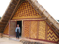 Reconstruction of one of the long houses from the settlement adjacent to the enclosure at Schletz. The decorative motifs and colours are taken from contemporary painted ceramics. |
Not surprisingly, the orientations of the monuments, the restriction of the entrances and the evidence of ritual burials in the broadest sense of the term have led to the conclusion that they are places of ritual and/or justice. Equally unsurprising is that a parallel should be drawn with Stonehenge and British timber circles and henges generally. Certainly both traditions have many architectural and astronomical elements in common, but the differences in date, space and culture cannot be discounted. Dating to around 5000BC, the central European sites are considerably older than the British material and it is unlikely that the two traditions are related. Nevertheless, we can see shared pre-occupations amongst diverse agricultural communities across time and space: common needs, concerns, observations and rituals . . . But please, do not call them ‘henges’.
Alex Gibson
Pools, Glowing Coals And Mud Volcanoes In Bulgarian Prehistory
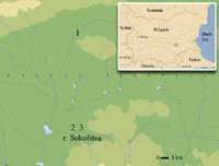 Location of key sites (1 The tell near the village of Ezero; 2 The mud volcano (Atanasivanova mogila) near the village of Mednikarovo; 3 The mud volcano near the village of Iskritsa) |
The results soon presented a critical problem. The pollen core had good preservation of pollen in two of the three main sections: the Late Glacial and Early Holocene (dated 13,400-7000 cal BC) and the Late Holocene (the Late Bronze Age-Roman periods: 1500 cal BC-AD 400). The only part of the sediment sequence that appeared to be missing from our first two cores was that part coeval with the tell occupation - a clear case of a palaeo-Sod’s Law - either because there was no sedimentation because the lake dried out seasonally or because the tell-dwellers removed mud from near the tell for house construction. Since coring in an area too remote from the tell to carry tons of clay showed the same sequence as the other two, we reluctantly concluded that Altithermal seasonal drying out of the lake surface had prevented sediment accumulation. However, during our discussions with local villagers about sediment removal, we discovered the secret of Ezero (Bulgarian for ‘pool’).
The former village school-teacher informed us of an extraordinary phenomenon that had persisted from the late 19th century AD until drainage works were carried out in the 1960s. The wetland next to the tell contained a series of five or six pools, each with a different size and varying characteristics, that were used by the villagers for different purposes and given different names. These pools were steepsided, with none larger than 30m in diameter. They filled up with warm subterranean water in the space of one day, only to empty again the next day; moreover, the pools never froze. The two-day cycle of rising and falling water occurred synchronously in each of the five pools - hence the name of the village. Anyone used to the ‘normal’ behaviour of lakes and pools would have been astonished at this natural phenomenon, which to most people would have been simply miraculous. The most plausible geological explanation for this occurrence is some kind of geothermal source; however, since the collapse of the pool system has been related to drainage of the wetland, it is also possible that the pool level was somehow linked to the river level.
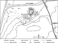 Map of the pools in the Ezero wetland (drawing: E. Magyari) |
A second natural phenomenon is located in a region south of Ezero, the Maritsa Iztok mining zone. The mound known as Atanasivanova mogila is located 2.5 km northeast of the village of Mednikarovo. The size, shape and toponym of the site (‘mogila’ is Bulgarian for ‘mound’) suggested that it was a burial monument, leading to Boris Borisov’s rescue excavation in 1987. The feature was 72m in diameter, more than 8m high and contained just one burial with no grave goods in a shallow pit. The unsuspected paucity of graves in such a big mound raised the question about the character of this feature. It was only after consultations with the mining geologist, Dr. Nedialkov, that it became apparent that Atanasivanova mogila is, in fact, a m u d - v o l c a n o .
Mud-volcanoes are not met elsewhere in Bulgaria but they form an important natural feature of the Maritsa Iztok region. There are several reasons for the appearance of these curious features, but the first and most important one is the so-called ‘ancient slumps’ on former slopes, now buried under hundreds of metres of sediments. The latter are the result of active neotectonics, most probably followed by seismological activity, as well as severe fluviatile erosion and intensive rainfall that result in rivers with a high water-level. During the active period, if the slump’s prism of active pressure reaches the coal layer, it causes swelling of the coal which, on the surface, looks like a small, elongated mound. The ‘eruption’ of mud volcanoes is related to the faults and cracks in the swelling zone, when deep-lying inrush waters following the leaks in the sediments reach the surface, sweeping away coal from the swelling and spreading to form mound-like features. Natural eruption of mud-volcanoes is neither rapid nor devastating but rather long-lasting. Such a burst may take a week to form a real volcanic shape until the fading of the slump movements.
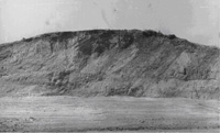 Mud-volcano near village of Mednikarovo, known as Atanasivanova mogila (source: field documentation, B. Borisov) |
Another attraction to prehistoric settlers was the coal seam in the profile of the river Sokolitsa, 3 km from the mud-volcano. A characteristic feature of such coal seams is their spontaneous bursting into flame at the very moment of the first surface exposure. This is not a devastating process, rather usually producing slow-burning embers and smoke. So it is likely that such spontaneous mini-eruptions took place near the mud-volcano after bursts of fluvial erosion. The illumination effects and the smoke may have attracted people’s attention and, after the active process had stopped, the location became a sacred place, marked by prehistoric deposition at sites such as Iskritsa (in Bulgarian, this word is the diminutive form of ‘spark’). In fact, the final event in the Late Chalcolithic Iskritsa II site sequence was the eruption of a mud-volcano that discouraged further occupation!
In conclusion, three extraordinary natural phenomena related to prehistoric monuments are located within 50km of each other in south-east Bulgaria - a series of filling-and-emptying pools next to the prehistoric Ezero tell, a mud-volcano used as a barrow for burial in the Early Bronze Age and spontaneous combustion of coal seams in the adjacent valley. These phenomena broke the ‘normal’ rules of natural behaviour - the first for bodies of water, the others for accumulated sediments. The regularity of the Ezero pools established a new form of cultural temporality as well as new relations between depth and surface; waters are normally flat, not moving up and down. If coeval with the prehistoric dwelling on the tell, the pools could have been used in ritual practices as much as for healing and the cleansing of bodies and clothing. Their multiplicity meant the possibility of differentiated use, some for special people, other pools for the whole community. The unpredictability of both the growth and continued eruptions of the Maritsa Iztok mud-volcanoes would have symbolised the natural dangers in the landscape and the transformation of solid clay into bubbling, fluid mud - perhaps a metaphor for the smelting of copper? The act of burial may have been an attempt to tame the danger and stabilize the ever-changing natural world and its hazards. Local inhabitants could have related the sparkling Sokolitsa coals to the general aesthetic of colour and brilliance that characterized much of Balkan prehistory. In each case, the potential of unusual natural phenomena as metaphors for other cultural practices led to their active participation in the cultural world of the Chalcolithic and Early Bronze Age.
We should like to close with an appeal for information. None of us has come across parallel examples of rising-and-falling pools, mud-volcanoes in association with prehistoric monuments or spontaneously combusting coals in alluvial sequences. We have also discussed the matter with a number of colleagues, none of whom has had any experience of such phenomena. We should be most interested to hear from Society members of any parallels to the phenomena described in this note.
Bisserka Gaydarska, Enikö Magyari and John Chapman, Dept. of Archaeology, Durham
University, Durham DH1 3LE
E-mail: b_gaydarska@yahoo.co.uk; eniko.magyari@dur.ac.uk;
j.c.chapman@dur.ac.uk
Society News
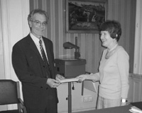
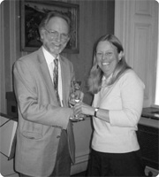 At this year’s AGM, the Bagueley Award for 2005 was presented to Dr Stuart Needham for his paper in PPS 71, ‘Transforming Beaker culture in north-west Europe: processes of fusion and fission’. Pictured presenting the award to him is the Society’s Hon. Editor, Dr Julie Gardiner. |
Alex Gibson, Hon. Sec.
The Europa Lecture 2006
 Vice-President Dr. Frances Healy presents the Europa prize to Prof. Marco. |
The lecture tackled problems familiar to anyone who studies iconography - the balancing of general parallels from the wider Iron Age world and specific interpretations for one area, and the issue of multiple possible readings from such silent evidence. As befits a Europa lecture, this gave it a value far beyond any one region, with approaches and interpretations which clearly resonated with many in the audience. It confirms again that the Europa lecture should be a fixture in the calendar of any committed prehistorian, providing a rare chance to hear international scholars presenting the latest ideas.
Fraser Hunter
Conference News
Conference in honour of John Wymer British Museum, September 21-22, 2006
A conference is to be held at the British Museum in September in honour of John
Wymer, who sadly died in February this year. The conference will cover the full
range of John’s interests, including the earliest humans, Palaeolithic art and the
Mesolithic period. It will include papers from Simon Parfitt, Jim Rose, Chris Stringer,
John McNabb, Mark White, Pablo Arias, Jean Clottes and Roger Jacobi. For further
details, please contact Nick Ashton, Dept. of Prehistory & Europe, British Museum,
Franks House, 56 Orsman Road, London N1 5QJ, or email:
nashton@thebritishmuseum.ac.uk
A tribute to the work of Aileen Fox 1907-2005: The Roman period in Wales & south
west Britain
University of Exeter, Saturday November 18, 2006 The Devon Archaeological Society
offers this up-todate review of one of the areas that most engaged Aileen Fox’s
interest in an affectionate tribute to her memory. Speakers will include John Allan,
Richard Brewer, Mark Corney, Peter Gathercole, Heather James, William Manning, Valerie
Maxfield, Henrietta Quinnell, Charles Thomas and Malcolm Todd. £17 for members;
£19 for non-members. Bookings and further details: Mrs Jill Cobley, Brookdene, Metcombe,
Ottery St Mary, EX11 1RU, jill@cobley1.fsbusiness.co.uk,
by November 4 or see the Society’s web site at www.ex.ac.uk/das/.
Bronze Age Forum 2006 School of Archaeology, University College Dublin, November
17-19, 2006
The next meeting of the Bronze Age Forum will be held in Dublin later this year.
The meeting is open to anyone with an interest in the Bronze Age archaeology of
Ireland, Britain and our nearest Continental neighbours. Twenty minute papers are
invited on new research and recent discoveries in any of these regions. To register
or to propose a paper, please download the application form at www.ucd.ie/archaeology/groups/BronzeAgeForum or contact
Joanna Brück, School of Archaeology, UCD, Belfield, Dublin 4, Ireland; email: Joanna.Bruck@ucd.ie.
Land And People: Conference In Honour Of John Evans
Cardiff University and the Prehistoric Society, March 24-26,
2006
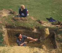 John excavating at Gwithian, Cornwall, in 1988 with Jacky Nowakowski looking on. |
Penny Spikins opened the Saturday morning ‘Mesolithic-Neolithic’ session by questioning assumptions about the egalitarian nature of Mesolithic society. She was followed by Alasdair Whittle who presented results from an AHRC and English Heritage-funded project that has provided new dates for deposits from long barrows and causewayed enclosures. Alasdair illustrated how great improvements in radiocarbon dating together with Baysian statistical modelling have resulted in much greater precision in Neolithic chronologies. An unexpected and welcome addition to the programme followed, with Frances Healy discussing findings from the soon-to-be-published Hambledon Hill causewayed enclosure. Clive Waddington then considered the rich archaeological landscape of the Millfield Basin and argued for a distinct shift from small-scale settlement and ritual activity in the Early Neolithic to the monumentalisation of the basin by the Later Neolithic. The Stonehenge Riverside Project was the subject of Mike Parker-Pearson’s paper and he used this opportunity to highlight the problems with conventional interpretations of the sarsen circle and trilithons at Stonehenge. Like Alasdair and Frances, he argued that we must be very critical of past chronologies for the British Neolithic and stressed the need for refined dates. Chris Evans gave the last paper in this theme and considered David Clarke’s excavation of the Great Wilbraham causewayed enclosure and how Clarke might have interpreted the site today.
An additional treat was provided over Saturday lunchtime, when Steve Mills and Amelia Pannett gave a short PowerPoint presentation, based on a sound recording and photographs taken during an experimental archaeology flint knapping event with John on the River Taff in 2004. This engaging presentation, accompanied by the sound of constant barking from John’s dog Darwin, ended with John’s comment on the debris produced: “Do you want to put those in a bag, or do you want to leave them here to express your identity?”
After lunch, Richard Preece kicked off the ‘Chalklands’ session by looking in detail at the Late Glacial and Post-Glacial environmental sequence at Holywell Coombe in Kent. Mike Allen then presented a paper that considered perceptions of the Wessex chalk as a natural open landscape during the Mesolithic and Neolithic and the contribution that detailed, small-scale studies have made in supporting or refuting this. Paul Davies highlighted the importance of modern snail ecological studies and illustrated how the results of such work may have major implications for palaeoenvironmental models. Charly French followed this by contrasting the results of environmental sequencing on the Wessex chalk and the Fen landscape. He used the results of work at Cranborne Chase to illustrate, as did others in this session, the importance of numerous studies that ultimately reveal many different palaeoenvironmental narratives. Julie Gardiner finished the session by outlining a research project on the important yet neglected Neolithic-Early Bronze Age of the Wylye Valley, Wiltshire, a project that was inspired by John Evans. That evening, the enjoyable conference dinner was held at Aberdare Hall and all delegates were invited to the bar at the hall for drinks following dinner.
Two new conference delegates appeared on Sunday, when John’s wife Vivian brought along their two much-loved dogs, Darwin and Jodie. They behaved very well throughout the day, with the occasional bark reminding us that they were present! The session on ‘Coasts and Islands’ was opened by Jane Downes with a consideration of the Early Bronze Age monuments of Orkney. Andrew Fleming followed this with a paper about St Kilda, showing how ideas about the isolation and exoticism of islands have affected interpretations of the archaeological and historic record of this place. Nicky Milner kept us in Scotland with a presentation about Mesolithic and Neolithic activity at middens along the west coast. Jacky Nowokowski then shifted the geographical focus to Cornwall and outlined some of the results of the Gwithian Archive Project 2003-2007, an ALSF-funded project to publish excavations at the site carried out in the 1950s and 60s. Finally, Niall Sharples gave the last paper of the conference, with his examination of Beaker settlements in the Western Isles, in which he stressed the importance of cultivation practices in the colonisation of landscapes.
Many of the sites considered over the three days of this enjoyable conference were sites that John Evans had actively contributed to, by specialist reports and research or through discussion and debate. Throughout the event, moving and amusing tributes were paid to a man whose research interests were varied and whose work has had a clear impact on many archaeologists and palaeoecologists. One fact came over very clearly: the work of John Evans cannot be compartmentalised by topic or geography. Although popularly known as a mollusc specialist, speakers at this conference emphasised his skills as excavator, fieldworker and, as Alasdair Whittle stressed, a developer of new ideas.
Jodie Lewis
Intriguing Discoveries At Ballybrowney, County Cork
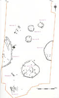 Plan of Ballybrowney Lower, Co. Cork (Archaeological Consultancy Services Ltd.) |
Some of the most striking features of the Bronze Age site are the different construction techniques employed. Enclosures 1 and 3 were distinctively defined by narrow trenches lined with flat stones on edge, suggesting that they originally contained palisades of upright planks. Inside Enclosure 1 lay Structure E, which was oval in plan with two central supporting posts, quite different to the three unenclosed structures (B, C and D), which consisted of circular slot-trenches with an internal ring of postholes. Enclosure 2 consisted of a shallow ditch with no stone-lining evident. Is it possible that these different methods of construction reflect differences in function or status?
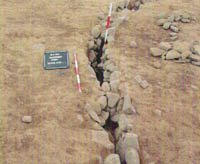 Stone-lined slot-trench of Enclosure 3 (Archaeological Consultancy Services Ltd.) |
Furthermore, the unenclosed Structures B, C and D were close together and appeared to face towards a common point, possibly Enclosure 3. If we assume them all to be contemporary, they may be arranged to reflect relations between the members of the household group and their social position relative to each other. Unfortunately, as with many developerled excavations, the full extent of the settlement was not exposed, making it difficult to form any conclusions, particularly as more structures may exist beyond the limit of the excavated area. It is also notable that Structures B and C were of similar construction, consisting of shallow slot-trenches with a circle of six internal post-holes and a central post-hole with entrances facing east. Structure D was only slightly different in morphology, with a porchlike entrance facing south-east. Structure B also appeared to be divided internally with two of the internal post-holes associated with diametrically opposed elongated cuts, c.2m from the ‘front’ wall of the structure. This may have segregated the space, dividing the structure into a ‘public’ and ‘private’ area, while simultaneously controlling movement through the structure.
Of note also was Structure A, located at the southern end of the site. It was interpreted as a possible cooking area, consisting of a two-phased semi-circular structure, two pits, one of which contained burnt stones, and a possible spit-like feature. This recognition of external hearths on Bronze Age settlements is important as it emphasises the possibility that ‘isolated’ fire-pits uncovered during excavations are only one aspect of a wider settlement landscape.
The material culture recovered at Ballybrowney, although not particularly rich or abundant, was certainly intriguing from a contextual viewpoint. A clear emphasis was placed on entranceways, something that can be paralleled on many other Bronze Age sites and that may relate to the importance of moving from the exterior to the interior or to the creation of a division between the individual household and the larger community. A post-hole at the north-eastern entrance to Enclosure 1 contained two sherds of pottery; a stone-lined pit/post-hole just inside the south-eastern entrance to Enclosure 1 produced a sherd of pottery; the southern entrance post-hole of Structure E contained four sherds of pottery and a saddle quern fragment, while the northern post-hole contained a sherd of pottery; the southern entrance post-hole of Structure B yielded a worked stone, possibly an anvil, and the northern post-hole produced a saddle quern fragment; the southern entrance post-hole of Structure C contained pottery and the inner posthole on the western side of the porch-like entrance to Structure D contained pottery, while the outer posthole on the eastern side yielded four pottery sherds.
Although some of these finds, particularly the single sherds of pottery, may be dubious, others are certainly worth exploring further, particularly the saddle quern fragments recovered from substantial post-holes defining the entrances to both Structure B and the enclosed Structure E. These types of deposits are frequently found on settlement sites and generally interpreted as the convenient re-use of broken artefacts as packing stones. While this is a possibility, there are other, less functional factors that could also be considered. The possibility of deliberate fragmentation, for example, cannot be overlooked, particularly when one considers how substantial these types of stone artefacts are. Their symbolic associations with food production may have furthered their importance, while their inclusion in a significant part of the structure, the entranceway, may also have been expressive. Thresholds are frequently noted, both throughout prehistory and history and from ethnographic examples, as liminal areas, highlighted in some way or viewed as transitional places, and sometimes associated with ideas of danger.
 Saddle quern in entrance post-hole of Structure B (Archaeological Consultancy Services Ltd.) |
Within its wider landscape, Ballybrowney is situated on the floor of the valley of the River Bride. It is likely that the landscape encompassing Ballybrowney was a naturally fertile region in prehistoric times, with good farmland both for crop and animal husbandry, a constant supply of water and extensive forestry located on the slopes of the surrounding uplands, which would have provided some degree of shelter. The importance of exploring sites within their landscape context has been highlighted in recent years with large-scale developments offering the opportunity to explore the environs of settlements and to identify ancillary activity areas. At Ballybrowney, for example, at least seventeen burnt mounds were known from the surrounding countryside prior to the N8 excavations, which revealed another twelve examples, with the closest in Curraghprevin townland, only 1.5km south of the settlement site. These high numbers surely indicate that there was an attraction to this location over a continuous period.
It is also important to consider the interaction between Bronze Age people and their surrounding landscape, and the ways in which they utilised it for a variety of purposes, combining the sacred and profane. Unfortunately, one of the largest obstacles to this type of research is proving contemporaneity between areas of activity.
Overall the importance of Ballybrowney is echoed in the diverse construction techniques employed, the spatial layout of the structures and the associated use of material culture in a complex, symbolic way. This site also furthers the possibility of ‘village’-like settlements in the Irish Bronze Age, something that remained elusive until recent years. Furthermore, Ballybrowney emphasises the advantages of large-scale developments for exploring the wider landscape and highlights the fact that the spatial limits of a settlement may extend much further than we usually presume.
Kerri Cleary
Irish Research Council for the Humanities and Social Sciences Scholar, University
College Cork
The Prehistoric Society Uk Study Tour, 2006
On 1 and 2 June, twenty-six members of the Society convened in Lybster, Caithness, at the Portland Arms. This hotel is well known as the ideal base for visiting the archaeological sites of Caithness and lived up to its high reputation. Caithness was at the forefront of Scottish prehistory during the nineteenth century and until the publication of the county survey volume by the Royal Commission on the Ancient and Historical Monuments of Scotland in 1911, but during the rest of the twentieth century it has been somewhat neglected and overshadowed in particular by Orkney. The new century has seen a welcome revival of interest thanks largely to our hosts, the Caithness Archaeological Trust (www.caithness archaeology.org.uk). The Trust promotes and co-ordinates the development of archaeology and aims to re-engage local people with their heritage as active participants, not passive bystanders. Central to the Trust’s projects is the support and involvement of the community, in an area where such a thing still exists in the proper sense of that abused word.
 Andy Heald deep in thought (and highly entertaining!) at Nybster broch. |
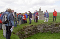
Most of our time was spent in the field visiting prehistoric sites, especially Neolithic chambered cairns and Iron Age brochs. Several of the cairns have been excavated, some - such as Camster and Yarrows - displayed for visitors, and all have been scrupulously studied by Audrey Henshall. Caithness has more brochs than any other county, but while these monuments are well known they remain badly understood. One way of improving our understanding of brochs should be their reconstruction as part of the Early Buildings Project at Spittal, which we were shown in his inimitable way by John Barber. Andrew Heald has begun to study Caithness brochs in the field and he took us to some excavated in the nineteenth century by Sir Francis Tress Barry, including Nybster, shown here.
We saw various standing stones, notably the multiple stones rows at Hill O’Many Stanes; our new Council member Kenny Brophy explained his recent work on stone rows, which casts doubt on aspects of the astronomical interpretations fashionable some years ago. Some of the smaller cairns we visited would have been Bronze Age, but for your correspondent at least the main thing we saw from this period was the fine bronze sword from Forse.
Caithness was of course part of Pictland, but few sites are confidently datable to the Pictish period. We did, however, see two symbol stones built into private houses at Latheron and Sandside and the Society is grateful to their owners for allowing access. There are spectacular medieval castles in Caithness and we visited the seat of the Sinclair Earls, Castle Sinclair Girnigoe, where much-needed restoration has begun. Caithness also has many harbours developed for herring fishing in the nineteenth century. Whaligoe Harbour is notable for its precipitous flight of 365 steps, which all members save your correspondent negotiated, and we enjoyed lunch at Lybster Harbour in the Waterlines Visitor Centre. The Society is also indebted to Isla McLeod for entertaining us to lunch at Thrumster House.
In his lecture following the Conference Dinner, where we were joined by Councillor Alastair MacDonald, Raymond Lamb of the University of the Highlands and Islands explained the development of nineteenth-century sporting estates and highlighted how little is known of the pre-improvement agricultural landscape of Caithness.
The presence during our tour of distinguished Scottish archaeologists from outside Caithness reflects the dynamic nature of its archaeology and we were especially fortunate to be accompanied on some days by Strat Halliday of the Royal Commission, who deployed his unrivalled expertise to our great benefit. While most Society members had travelled north to cross the Ord of Caithness, Paul Humphries came south to lead several of our visits and to tell us something useful wherever we went.
The Society is most grateful to everyone mentioned already, to our other evening speakers, Noel Fojut, Jonathan Clark and George Watson, to the many other people in Caithness who helped make our tour so memorable and especially to Emma Sanderson, the Trust’s Archaeological Development Officer, who expertly co-ordinated our programme. I would urge all Prehistoric Society members who can do so to visit Caithness and see for themselves its rich and varied archaeology.
Brendan O’Connor
Hidden Wessex: What You Don’t See From The Road
This April saw the second annual student study tour offered by the Society, designed to provide an affordable way of visiting and studying particular sites and landscapes, and led by those who research and excavate them. This year’s trip covered considerable tracts of the Wessex region with an emphasis on the inaccessible bits and the archaeological sites contained therein. Led by Julie Gardiner, Mike Allen, Bob Bewley, Dave McOmish and Frances Healy, all must be thanked for giving up their weekend and for the time it took to organise the tour and take us round the sites.
 The students visit Hambledon Hill for a grand tour by Frances Healy. Note the fugitive from Time Team: a passer-by was heard to ask “how we managed to get him” for the weekend, to which our Hon. Editor replied - “oh, he’s my greatest fan”. |
Saturday saw us head up the Wylye valley at a relatively early time (for us students at least). Our first ports of call were the Iron Age hillforts of Codford (recent excavations here are reported on in this issue) and Battlesbury. These offered excellent views of the surrounding landscape and provided a good opportunity to discuss important themes in prehistoric studies such as the intervisibility of sites and the re-use of particular places throughout prehistory (themes revisited throughout the two days). Having viewed some nice earthwork monuments, talked about the work undertaken by Mike, Julie and Wessex Archaeology, and observed the odd burnt-out tank, we were led by Dave onto the SPTA, partaking of a spot of lunch on the ramparts of Knook Camp. This and the nearby Romano-British settlement still survive as visible earthworks, offering an insight into the level of preservation across the SPTA, so much so that it is almost worth talking about the Romans!
However, we moved swiftly away from the historical period and travelled on to East Chisenbury for a discussion of the excavations and a quick lesson in auguring and why it’s useful for archaeologists, as well as picking up the odd bit of pot from a rabbit hole before heading on to Weather Hill and the ridge above Snail Down barrow cemetery. Here, the breathtaking preservation of the whole landscape - with Sidbury Hill also visible - was amazing to see (bar the odd barrow apparently squashed by a tank), yet it also brought home the loss we have suffered due to the introduction of deep mechanical ploughing since 1945. Faced with this stark picture, we can only envy those who studied the landscape before the World Wars. With so much to take in from the first day, we returned to Salisbury, some of us a bit redder in the cheeks thanks to the sun, for a bit of food and much needed fuel in pint form. With a slight lie-in allowed for Sunday, we set off south in search of more earthworks and journeyed to the far side of Cranborne Chase where Frances Healy provided us with an excellent tour of Hambledon Hill. We walked through the surviving parts of the Neolithic monuments and across areas previously excavated and now under the plough-soil. The tour was finished off with a visit to the long barrow on top of Hambledon which also allowed us to briefly discuss the well-preserved earthworks of the later hillfort.
We journeyed back through Cranborne Chase and spent the afternoon in the company of Martin Green who can claim the odd prehistoric monument on his land. These include a bit of the Dorset Cursus, a couple of henges, some Bronze Age barrows, settlement sites and a natural shaft giving an unbroken environmental sequence through the Mesolithic, Neolithic and Bronze Age (and a recent furry victim). As well as meeting Martin and visiting the superb museum there, we were introduced to the most ancient occupants of Down Farm, Ron and Reggie Naled. Naleds are naturally occurring earthworks relating to the end of the last Ice Age and these examples are unique for the Wessex region of Britain.
The tour offered by the Society gave a unique opportunity to visit some well preserved archaeological sites and to view Wessex from a slightly different perspective, as the quality and quantity of surviving prehistoric earthworks is something special. To be able then to put them into their wider landscape context, when so many examples form the staple of undergraduate essays and case-studies, and to discuss them with those who study them was a great opportunity. I would recommend next year’s tour to any student as an excellent opportunity of broadening their knowledge of prehistory, meeting like-minded people and having a good time away from the libraries, essays and theses of student life!
Alex Lang,
Institute of Archaeology, Oxford University