|
|
|
|
The
Dead Beneath Their Feet: Housewarming C. 1000 BC - Roundhouse Rituals
At Cladh Hallan |
|
THE
DEAD BENEATH THEIR FEET: HOUSEWARMING C. 1000 BC |
||
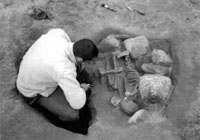
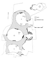
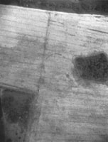
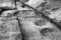
In previous seasons we had found a number of sacrificial dog and sheep burials (dated to 900-750 BC) underneath the successive Early Iron Age floors of the middle roundhouse. This year we found human skeletons beneath all three houses. The first to be found was a baby, buried lying on its front below the third floor of the north house. Lower down, two adults (a man and a woman both aged over 40) had been buried in crouched positions beneath the first floor of the north house. Under the first floor of the middle house we found another crouched burial, of a 12-year-old, possibly a girl. The burial under the south house was that of a rotted 3- year-old child, dead long enough for all but its torso to become disarticulated. Since these houses form just one end of a row, it is probable that the community needed some 7 or 8 corpses in total, all at once, for these foundation offerings to be buried before the floors were laid. The rotted child and the adult male in the north house were dead some time before burial and the woman may have been dead long enough for her teeth to be extracted with ease. Eerily, she was buried holding her upper lateral incisors in each hand. The man, who had also lost all the teeth in his upper jaw (the molars lost many years before and the front teeth probably falling out after death but prior to burial), had been provided with someone else's mandible. Otherwise, the remainder of his bones were present, presumably held in place by a tightly wrapped shroud which had not covered his face. His tightly flexed posture is reminiscent of a 'mummy bundle' and raises the possibility that the corpse was retained for months if not years before burial beneath the new house.
Evidence for the normal funerary rite of the Late Bronze Age came from outside the door of the north house. A small stone-laid cremation pyre contained the burnt bones of children. This stone platform was built against an unusual double pit within which were the broken bones of an adult's knee. Close to this feature, in a later layer, we found a gold-plated bronze penannular 'hair ring'. Human skull fragments came from one of the three large pits dug in front of each roundhouse prior to building. Discovery of the human burials was particularly exciting because we had previously predicted their locations within the northeast corners of each house. Building on Andrew Fitzpatrick's diurnal model of the sunwise arrangement of roundhouse space, we had proposed that the life cycle from birth to death was similarly represented by the circularity of the house - with birth symbolised in the southeast and death in the northeast. All but one burial fitted the pattern: the woman with her teeth in her hands was buried on the south side of the northern house (though at least she faced west, adhering to the sunwise directionality of movement exhibited by the human and animal burials). Cladh Hallan's central roundhouse is also associated with a dump of clay mould fragments for making bronze swords, spears and ornaments. Most of these lay within a 'floor' layer which had accumulated outside the door, with other fragments lying on the floor inside the house. This central house was the largest of the three whereas the south house was the smallest and the most impoverished. All three appear to have been dwellings, at least in their earliest phases, and yet each differs markedly in architecture and associated artefactual assemblage. The symbolic emphasis on the house, as seen in brochs and the other architecturally elaborate Iron Age houses of the Outer Hebrides and other parts of the Scottish highlands and islands may well have its origins in Late Bronze Age sites like Cladh Hallan. The central house had its wall cores increased in thickness to 3m, even though their original height was not greater than 0.5m. Elsewhere in the British Isles, the burials of humans and animals and the deposition of metalworking debris are confined to the outskirts and edges of settlements. Here in these unenclosed settlements it was the house which was the locus of everyday life in all its forms, social, economic and symbolic. Mike Parker Pearson Peter Marshall Jacqui Mulville Helen Smith
|
Aerial
photography, reconnaissance, mapping and understanding the landscape
have been carried out as part of aerial survey for many years in Britain
and since the ending of the Cold War (1989-1990) aerial survey has
expanded enormously throughout out Europe. Normally aerial archaeologists
measure their success in the number of new sites recorded in dramatically
dry summers but the latest annus mirabilis is being measured in the
number of meetings, conferences, workshops and training sessions which
have taken place (from November 2000 to November 2001) with a NATO
grant, EU Culture 2000 grant and contributions from participating
institutions across Europe including English Heritage and the British
Academy. These events have been part of a year long project, Conservation
through Aerial Archaeology, which has been very successful in developing
a network of interested practitioners as well as raising the profile
aerial survey for archaeology. Thus it is an appropriate time to prepare
this short piece, which is intended to highlight some of the prehistoric
discoveries made across Europe in recent years. Aerial reconnaissance in northern England in 2001 found good conditions in Yorkshire, Lincolnshire and Nottinghamshire and the notable discoveries were a long barrow near Louth, Lincolnshire (see Jones 1998 for background); pit alignments and other structures in the general vicinity of the "ritual landscapes" near Ripon, North Yorkshire; new square barrows on the Yorkshire Wolds (see Stoertz 1997 for background) and numerous late prehistoric and Romano-British sites in the region (Pete Horne and Dave MacLeod pers. comm.). In southern England the conditions were mixed with a number of discoveries in the Cotswolds of enclosures which may be late prehistoric (Damian Grady pers. comm.) but this is an area which will be studied as part of a National Mapping Programme project (Bewley 2001), beginning in April 2002. As already mentioned the mapping projects in Britain discover, interpret and record new sites every day and in England the National Mapping Programme (organised and funded by English Heritage) has begun to transform our understanding of prehistoric settlement in many areas (especially places like Cornwall). Individual sites are recorded for the first time and the most recent notable examples are a long barrow and a causewayed enclosure in Norfolk (see article in this issue), and this after the latest publication on the subject (Oswald, Dyer and Barber 2001). There have been many discoveries on the chalk in southern England, some in the Avebury area which have been published (Bewley et al. 1996) and others (the oval (neolithic) enclosure at Beckhampton) which led to excavations by a team from Southampton University, which in turn led to the confirmation that Stukeley was right and Avebury did have a western (Beckhampton) avenue. Recent mapping of the Knowlton area in Dorset (for the report on the excavations of the South Henge by Bournemouth University) has added new information, including at least four possible square barrows, a type of site not previously recorded in this region (Cathy Stoertz pers. comm). Similarly mapping (as a training exercise for student placements) of the area centred on Liddington Hill, just south of Swindon has provided good evidence of a (ploughed out) enclosure, with similar dimensions to the hillfort at Liddington, on a small promontory on the other side of the valley. Its size, shape and location make this a strong candidate for a hillfort (or defended enclosure) to control access to the valley (Simon Crutchley pers. comm). Recently the Stonehenge Word Heritage Site has been re-mapped using aerial photographs, partly for the management plan but mainly in advance of the redevelopments of the roads (A344 closure, dualling and tunnelling of A303 and Winterbourne Stoke bypass). Despite the intensity of survey work in the area, a rash of new enclosures was discovered in the southern portion of the survey (south of Stonehenge itself). These are thought to be possible Bronze Age and/or Iron Age farmsteads (Helen Winton pers. comm.).
Finally,
but still on the chalk, the Lambourn Downs mapping project produced
evidence for groupings of banjo enclosures (hitherto only single examples
had been known in this area) around the, head of a (now) dry valley
with all the funnels of the banjos pointing towards the valley (Helen
Winton pers. comm.). The work by Roger Featherstone in the Cherwell
valley (Oxfordshire) has now been published (Featherstone and Bewley
2001). This reports the discovery of hundreds of banjo enclosures (in
the dry summers of 1995 and 1996) in an area which was not noted for
its Iron Age settlement material and which had been difficult to reconnoitre
until the United States Air Force closed its airbase at Upper Heyford.
This closure was as a consequence of the ending of the Cold War and
in Europe there has been a dramatic rise in aerial survey activity since
1990. Much of the recent work has been pulled together in the proceedings
of a NATO funded workshop in Poland (Bewley and Raczkowski 2002). It
is appropriate to report first of recent work in Germany, where Otto
Braasch has led the way in encouraging aerial reconnaissance in the
new Germany and in neighbouring states.
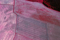
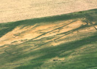
Covering such a large area as Germany, there are always areas which produce results for Otto Braasch, and in particular there have been a number of discoveries of Neolithic sites, causewayed enclosures, long houses, henges and pit alignments (Braasch 1995). Figures 1 and 2 are but two examples of the kind of sites which are being recorded on a regular basis by Otto in most parts of Germany, and he is also working in the Baltic states, Poland, Hungary and Italy (with interests in Romania and Bulgaria!).
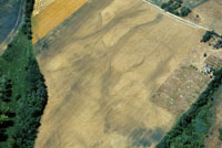
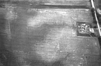
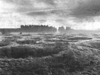
Future applications. The scope of aerial survey has grown enormously over the past twenty years and especially in the recording and understanding of industrial and twentieth century buildings. Part of this work is for monitoring and assessing the condition of sites and buildings. Monitoring sites from the air has been applied recently in England after learning from the pioneering work in Wales begun by Chris Musson and now continued by Toby Driver (RCAHMW). A good example of this from England is the hillfort at Idbury in Gloucesterhire (Figure 5); despite being a scheduled monument, the ploughing regime is allowed to continue (under class consent of the 1979 Ancient Monuments and Archaeological Areas Act). In this photograph its internal features as well as the ditch and bank are clearly visible, but one has to ask for how much longer? On looking up the record for this site (NMR No. SP 21 NW 2) I noted that it was visited by an OS recorder (none other than Leo Rivet on the 16th May 1956 - by sheer coincidence the day I was born) who records that "The camp is still being ploughed and was under growing crops, but there were faint indications of an entrance on the north side." Little change in protection in 45 years! |
|
|
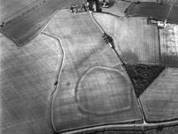 Figure 5. Idbury hillfort, Gloucestershire. Photo by Damian Grady. NMR © English Heritage. NMR 21246/23. SP 2219/31. 22 June 2001. |
|
For
aerial survey to continue its important and useful role in providing
greater understanding and in contributing to the management of the
historic environment, it has to develop new techniques and methodologies,
but also it must form part of national survey strategies which include
reconnaissance, mapping, and follow-up fieldwork. Robert Bewley Bewley R. 2001. Understanding England's Historic Landscapes:
an aerial perspective. Landscapes. 2(1):74-84.
|
The closest recorded Neolithic finds to the enclosure are a reputed assemblage of twenty to thirty polished and part-polished stone axes, said to have been recovered by farmworkers from a field situated approximately 500m to the south east (SMR 6199). A relatively small oblong enclosure, approximately 25m long and 12m wide, is visible as a cropmark 300 metres to the South West of the site. This feature is morphologically similar to enclosures interpreted as a form of Neolithic long mound (Jones, 1998). There are also numerous Bronze Age barrows within the environs of the site, with a dense concentration occupying the heathland to the immediate north of the enclosure. This is likely to be the third causewayed enclosure from Norfolk, together with sites at Roughton and Buxton with Lammas (Wade-Martins 1997, 1999; Oswald et al 2001). Another potential site at Hainford has rightfully been dismissed from the class (Oswald et al 2001). All of the Norfolk sites appear to be approximately circular, defined by relatively narrow ditches and pit sections, interspersed with narrow causeways. These enclosures are generally defined by single ditches, however the recently published plot of Roughton (Oswald et al, 2001: fig. 6.7), has identified a second, more ephemeral, inner ditch or feature.
The three possible Norfolk examples are relatively small and have a marked circularity in comparison to many other causewayed enclosure sites in England. This contrast in morphology has caused some to question their date and relationship to other causewayed sites (Ashwin, 1996). While the majority of causewayed enclosures appear to have been created in the fourth millennium BC (Oswald et al, 2001) it has been suggested that the smaller, more circular sites have more in common with hengiform monuments of the later Neolithic and early Bronze Age. At present no excavation has taken place on any of the Norfolk 'causewayed' enclosures and therefore none of these chronological questions can be adequately answered. The smaller dimensions of the Norfolk sites may be a reflection of the size and dispersal of the communities creating, maintaining and using them and it may not be necessary to assume that they occurred later than elsewhere in Britain. The spatial relationship between causewayed enclosures and other earlier Neolithic monuments has long been recognised (Oswald et al, 2001), in particular the close positioning of some causewayed enclosures and long barrows. The enclosure at Roughton appears to be flanked by two long barrows. A possible cursus identified along the same alignment to the North (Oswald et al, 2001; fig 6.7), may require further investigation before it is assigned a Neolithic origin. However, the barrows alone attest to the significance of the location at Roughton during the Neolithic. It is possible that a comparable situation is emerging at Salthouse. The small oblong cropmark located near to the new enclosure may represent the remains of a Neolithic barrow. The relationship between these Norfolk causewayed enclosures and long barrows is reminiscent of other British sites and could also be taken to indicate an Early Neolithic date for the construction of these monuments. It is hoped that the work of the Norfolk NMP will help to answer some of these morphological questions and further define the spatial relationships between the causewayed sites and other Neolithic monuments. Mark Brennand, Henrietta Clare
and Sarah Massey References
|
Here we wish, however, to report briefly upon some of the excavation results from the last two seasons. Fieldwalking had already identified an area close to the innermost point of Dyvig Fjord as worthy of further investigation. We had recorded a blue glass bead, indicating late Iron Age or Viking activities, and further up the slopes an unusually high frequency of pottery as well as iron working debris and some flint tools. In combination with the local topography and place names, these finds suggested a likely location for a Viking Age settlement. However, further investigation, organised by Haderslev Museum found nothing, and we were resigned to these being random stray finds. Meanwhile, due to our unrelated interest in the clustering of sites around the area of the later medieval village of Holm, we decided in 1999 to carry out trial excavations at the top of the slope leading down to the northern edge of the fjord. Three 50 metre long trial trenches were dug. Two of these were placed at the top of the area previously investigated with a view down towards the water, while the third (trench 3), equally close to the coast, was 'tucked-away' behind the hilly edge moraine. While the three trenches contained several features, none of these were particularly noteworthy apart from providing dates from the Late Bronze Age to the Roman Iron Age. There was one exception, however. At the northern end of trench 3 we found a few very abraded sherds of unmistakable early Middle Neolithic date. This was a surprise, despite the recovery of flint tools during fieldwalking, since the area to the East had been empty of flint residues. The sherds were thus in a peripheral location in relation to the area used during the Middle Neolithic, which made them even more interesting. The Neolithic sherds, small as they were, were highly decorated and included a fragment of a so-called clay-spoon, suggesting they may derive from a megalithic monument. Although there was no suggestion of features on the surface, this had to be investigated. During the 2000 and 2001 seasons the excavation of further trenches started to produce surprises. The trenches, despite the limited area covered, revealed an entirely concealed history of repeated use. The first sign of use consisted of at least three megalithic structures, of which we have now excavated two. Amongst the startling discoveries is how the people constructing the megalithic monuments 'coped' with the loose sandy natural in this area by bringing in pure clay to be used as a foundation for the stones around the grave chamber and as 'holding-material' for the dry-wall (see Figure 1). Along the south-eastern section of the now missing kerb-stones, we found large amounts of heavily abraded sherds from high quality decorated vessels - presumably the remains of pots placed around the entrance area. The pottery shows the three monuments to be of the same date, Middle Neolithic period II. To add to the sense of revelation, within the grave area of each of the excavated monuments was found a much later Corded Ware battle axe, such as are typically found in graves from the end of the Neolithic. Interestingly, the two axes are typologically very similar but the quality of their production is remarkably different. One of the axes was placed in a shaft-grave dug into the base of the chamber, while the other was placed on the surface within the other grave chamber. This seems to be a difference reflecting changes through time in the construction of Corded Ware graves, and it is possible that the graves are local interpretations of changing customs on the mainland. This, however, was not the final episode. Much later, around 1000-1100 AD, in the construction of a number of sunken-floor buildings, the chamber of one of the megalithic graves was dug through, and the clay platform and its embedded dry-wall reused - maybe as some kind of associated area or as a foundation for a roof-carrying post. Unravelling this sequence, the long time gaps must be noticed. Therefore, although we might like to see this as an example of prehistoric communities deliberately reusing and making connections with the past, some scepticism about the consciousness and reasons for the link must be voiced. While the repeated incorporation of the earlier structures is clearly deliberate, its motivation is potentially complex. The Corded Ware reuse of the grave chambers may thus simultaneously have been affected by a sense of reverence for this as a special place, maybe even as a burial monument, and yet at the same time found it appropriate to assault it. The area investigated was limited and the time spent short; but the many surprises and the various forms they took, were the kind of valuable lessons that make fieldwork a joy. Marie Louise Stig Sørensen,
Sam Lucy,
|
|
The society tries to arrange a variety of events for its members. Expert guides are a feature of its foreign and UK study tours. Frequently, the tours offer the chance to see material which is not publicly available, or simply difficult to access. This year's foreign study tour will certainly take you off the beaten track....... THE PREHISTORIC SOCIETY OVERSEAS STUDY TOUR - SOUTH
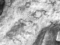
WEST LIBYA
The tour will explore the wonderful rock art, rock shelters, palaeolake sites and amazing desert landscapes in the south-west of Libya. The prime mountain areas of painted rock art (Tadrart Akakus) and engraved rock art (Messak Sattafet) will both be visited, along with neighbouring depressions and sand sea landscapes, which also contain important evidence for early human activity. Particular interest focuses on the transition to farming and the emergence of agriculture in this zone, leading to the formation of a complex state in the 1st millennium BC (the Garamantes). International flights are into and out of Tripoli, and there will be the opportunity to visit the impressive National Museum there. Internal flights will take you to Sabha, and accommodation for the 5 nights in the south will be in camps with tents which sleep 2 or 3 each, on soft bedding rolls. You will need to take your own sleeping bag. There are, however, electricity and shower / washing facilities and toilets. For further details and booking form contact:
|
|
|
THE PREHISTORIC SOCIETY UK STUDY TOUR SUMMER 2002
|
| |
The Prehistoric Society Home Page |