PAST
Registered Office University College London, Institute of Archaeology, 31-34 Gordon Square, London WC1H 0PY


NUMBER 34 APRIL 2000


NEOLITHIC TREES IN LANGSTONE HARBOUR, HAMPSHIRE


We first wrote about the Langstone Harbour Archaeological Survey Project in 1993 (PAST 16) when we had just completed the first, two-week field season of what was to become a moderate-sized intertidal project. During the intervening years the project flourished, completing two further seasons of work in the intertidal zone and underwater, including survey, artefact searches, augering and excavation in both. The project is now coming to a close and is shortly to be published as a CBA research report (Allen and Gardiner in press). One element of the work involved the recording and sampling of two areas of relict submerged 'forest' and during the final months of the project a Prehistoric Society research grant enabled radiocarbon dates to be obtained for the trees. Somewhat unexpectedly, but excitingly, the dates are Neolithic.
         Langstone Harbour lies between Portsmouth and Hayling Island on the south coast of England. The shores and islands within the northern part of the harbour have long been known for their archaeological content and previous limited field investigations indicated the presence of material of Mesolithic-Roman date (Bradley and Hooper 1973). Our detailed archaeological survey was able to systematically record and quantify these assemblages, enabling interpretation of the physical and social development of the area (Allen and Gardiner in press). The project was multi-disciplinary, involving teams from Wessex Archaeology, Portsmouth University, the Hampshire and Wight Maritime Trust for Archaeology and the Departments of Archaeology and Oceanography of Southampton University (see PAST 16). Throughout the project two local amateur archaeologists, Arthur Mack and John Bingeman, provided invaluable assistance and it was Arthur Mack who first drew to our attention the presence of submerged trees - inevitably in a fairly inaccessible part of the harbour.

         Arthur's first sighting of the trees was some 25 years ago. He recalled that there had been at least eight tree stumps and trunks visible in an area of about 6 x 6 m, but these were only rarely exposed at very low tides. Fortunately for the project, Arthur rediscovered the 'forest' after the end of our third season of fieldwork (1995) and photos taken at the time (Fig. 1) provided a dramatic conclusion to our interim statement presented to the Solent Archaeology seminar at Portsmouth University later that year.
         We were not able to record and sample this site until September 1997, for which we enlisted the help of Dr Alan Clapham, and ensured that the team from Portsmouth University were on hand to survey the findings with their GPS technology. The aim was to map the trees, record the direction of fall of any trunks, sample the peat ledge on which they had been growing for pollen and plant macrofossils, and search for any artefacts.

Fig 1.
Fig. 1 Tree stump at Baker's Rithe, Langstone harbour, as discovered in1995. Photo: John Bingeman

         Access to the site in Baker's Rithe (SU 6926 1041), which lies between Baker's and North Binness Islands in the north of the harbour, was provided by Arthur Mack on an extremely low tide. We had approximately 45 minutes in which to carry out the necessary work before the tide began creeping back under the mud and we all began to sink above our wellies! On the boat trip out we passed a peat ledge north of Russell's Lake, on the west side of the harbour, upon which we could clearly see an array of large branches and tree stumps. In 40 years of working in the harbour Arthur had never before seen these! The opportunity was taken, while equipped and experienced people were on board, to record this site too.
          By the time of our visit to Baker's Rithe, only one stump, a series of associated roots and a section of trunk remained in small area of 3.5 x 2 m - less than a quarter of the area that once existed (Fig. 2). The brown fibrous peat ledge at c. -1 m OD was about 0.2 thick over clay. No artefacts were found but subsequent analysis by Alan Clapham recorded microscopic charcoal in the peat. The trees were identified as oak, yew, and alder. In December 1999, following severe storms, more fossil trees were observed covering an area of nearly 10 sq m including more branches and another tree stump. Scouring of the surface had exposed and revealed the roots of the stump we had examined, as well as another fallen trunk, clearly showing where it had broken in antiquity.
         Our discovery of the trees at Russell's Lake in 1997 must indicate the erosion and loss of overlying clays to expose the trees on a 0.2 m thick peat ledge at -0.5 m OD. The site consisted of three dispersed in situ oak and willow trunks, one group of roots (willow), and two branches (oak) over an area of about 25 x 12 m. All the branches and fallen trunk were straight a relatively slender (0.2 m in diameter), and one was over 4 m long. The peat shelf, although only 175 m from that at Baker's Rithe, was nearly 0.5 m higher and the peat was very different in nature, being dark brown, woody and more variable in thickness; it was generally about 0.2 m thick, as it was at the edge of the shelf, but away from the trees it was up to 0.48 m. A few burnt flints were recovered from the thinning edges of the peat.
         Although dendrochronology was attempted on oak from both sites, none would date. They had very close rings suggesting that they survived under ecological and physiological stress, perhaps due to a high water table or inundation. The radiocarbon dates from the two site indicate that they were both of Neolithic date but separated by about one millennium.
Fig 2.
Fig. 2. Plan of the relict 'forest' at Baker's Rithe. Drawing: S.E. James (from a measured sketch by Julie Gardiner)
Radiocarbon Results

Site OD material lab no result BP calibration
Baker's Rithe -1m oak stump (BB) R-24993/2 3735±60 2310-1950 cal BC
Russell's Lake -0.5m oak branch (AEA) R-24993/1 4431±70 3350-2910 cal BC

         Unfortunately pollen was not preserved (Rob Scaife, pers. comm.) but analysis of the waterlogged plants and land snails provided a picture of the local environment. This indicated a development from an open fen habitat to one of fen/carr woodland with temporary drying-out phases. The woodland comprised oak, yew, willow/poplar, birch, and alder, with an understorey of hawthorn. The ground flora was dominated by species which prefer damp conditions but there was also evidence of open and slow flowing freshwater. There is surprisingly little evidence for any maritime or brackish environments. In fact, only at Russell's Lake, the younger of the two sites, are there a few remains of Suaeda maritima (annual sea-blite) indicating that a maritime influence may not have been too far away (although Clapham indicates that the possibility of modern intrusion cannot be ruled out). This might indicate seasonal or extreme flooding events creating some inland brackish lagoons.
         From research in the rest of the project we know that these woods existed in a low-lying inland basin drained by at least two rivers, with freshwater pools and alder carr (alnetum). Although the streams may have been tidal, and the area was a part of the coastal plain, it was not itself coastal or maritime. Open grassland and alder carr existed in the valleys and adjacent to the rivers but open woodland dominated by lime existed on the drier and higher adjacent land. The fringing chalkland would have supported denser mixed oak, hazel, and lime woodland. Analysis of the lithic assemblage indicates that flint itself was one of the major resources of the area, being collected from large exposures of riverworn gravels in the river beds. There is no clear evidence for activity in the earlier part of the Neolithic. A handful of leaf arrowheads are recorded but represent no more than a few isolated losses over possibly many hundreds of years. Although some implements attributed to the late Neolithic-early Bronze Age have been recovered, most of the assemblage is later in date and no Neolithic pottery has been recovered. While it is difficult to quantify the material of this date, sufficient diagnostic flintwork survives for us to be able to agree with the assessment by Bradley and Hooper (1973) that this is an essentially non-domestic assemblage, possibly representing seasonal, short-term grazing and associated activities. The flint gravel itself was one of the main resources exploited. In addition to the flint resource, this wild landscape was probably borne to migrating large animals and provided an ideal seasonal hunting ground. Although, today, the area is dominated by the coastal and harbour environment, the results of the project shows a quite different picture in the Neolithic.

Allen, M.J. & Gardiner, J. in press. Our Changing Coast: a survey of the intertidal archaeology of Langstone Harbour, Hampshire. York: Council for British Archaeology Research Report
Allen, M.J., Gardiner, J., Fontana, D. & Pearson, A. 1993. Archaeological assessment of Langstone Harbour, Hampshire, PAST 16, 1-3
Bradley, R.J. & Hooper, B. 1973. Recent discoveries from Portsmouth and Langstone harbours: Mesolithic to Iron Age. Proceedings of the Hampshire Field Club & Archaeological Society 30, 17-27

Michael J. Allen & Julie Gardiner


EDITORIAL NOTE


This issue of PAST has been compiled by Julie Gardiner. Unfortunately, Sara Champion has been very unwell of late and was unable to weave her editorial wand at the appropriate time. I am sure that all members of the Society will join me in sending her all best wishes for a speedy recovery and return to the flock. We hope to see her steady hand back at the helm in time for PAST 35.
          In the meantime I must thank everyone who rallied round at very short notice to help me put together this issue - all the contributors and especially Josh Pollard, John Cruse, and Patrick Ashmore who responded to my cries for help and cajoled or threatened several people into instant submission (pun intended!). If anyone did send in anything that does not appear here, I do apologise but circumstances have not permitted me to scoot down to Southampton and raid Sara's office. It will appear next time. Please note that copy for the next issue should be sent to me at the address on the front page. I will pass all material to Sara when she is ready to receive it.
          In this issue we have included a 'splash' on General Pitt Rivers to remind all you youngsters who he was and what he did and encourage everyone to sign up for the picnic - make it the biggest event we've ever had and have a great day out. Details are included again in this issue and booking has been extended to 30 May.
          January saw the launch of our new publicity leaflet and we are delighted to report that it has already brought in around 100 new members - that's as many as we usually get in a year! Tessa is lying down in a darkened room. Those of you who sent in a membership form as well as your normal subscription renewal will not be charged double but we're glad you noticed the new leaflet.
          I have not received any conference reports but I understand that the 'Talking Rubbish' seminar on 25 March was a sell-out and a very good day, as was the 'Food, Identity, and Culture' conference held in Sheffield in February. Presentations by students as well as more established speakers were a feature of both.


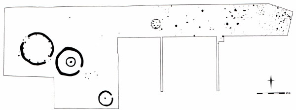
HENGE TO HOUSE - POSTCIRCLES IN A NEOLITHIC AND BRONZE AGE LANDSCAPE AT KING'S DYKE WEST, WHITTLESEY, CAMBRIDGESHIRE

South-cast of the Flag Fen basin, near a small land bridge that once joined the fen islands of Whittlesey and Northey, recent excavations have encountered an intricate pattern of later prehistoric monuments and settlement. The work, which has led to the unexpected discovery of a henge, round barrows, and areas of Bronze Age settlement (Fig. 1), was undertaken by the Cambridge Archaeological Unit over the winter of 1999/2000 on behalf of Hanson Brick Ltd in advance of clay extraction. Representing a microcosm of the surrounding larger landscape, the site at Whittlesey presents an opportunity to look at relationships between monuments as focal places and contemporary occupation during the later Neolithic and Bronze Age. Materially the site was rich, enabling a resolution of detail that only large, landscape-scale open-area investigations permit.
          The henge consisted of a circle of 12 post-holes c. 30 m in diameter, enclosed by two C-shaped ditches, leaving causeways on the north-west and south-east. Marking the causeways, two pairs of extra posts made elaborate porch-like entrances. The post-pits were large (up to 1 m in diameter) and many contained a dark charcoal-rich basal deposit that included large pieces of burnt oak. Little was found within the primary fills of the ditches, although the closing fill around the south-western part contained a dark midden-like deposit replete with sherds of Food Vessel, Collared Urn, worked flint, and fragmented animal bone.

Fig 1.

Fig. 1. Plan of the Whittlesey excavations. Drawing: Cambridge Archaeological Unit

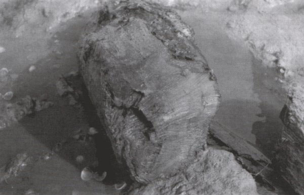
          Outside the south-east entrance of the henge was the larger of the two barrows (28 m in diameter). Penannular in plan, its entrance or causeway was also oriented to the south-east. At the barrow's centre was a deep grave cut containing a single inhumation in the remains of a 'log' coffin, and buried alongside the individual was a small polished flint knife. A small ring of posts encircled the grave and next to this was a single cremation burial. The southern circumference of the barrow also contained two later Bronze Age cremation deposits. The second, smaller barrow (15 m in diameter) shared the same penannular plan, but this time oriented towards the east. Less elaborate than its counterpart, it was distinguished only by a central burial. Situated between the two barrows was a small 'satellite' cremation cemetery containing both Food Vessel and Collared Urn.
         North-east of the henge and barrows were traces of Early Bronze Age settlement. Pits and post-holes, including at least one circular structure 4 m in diameter, contained impressive Collared Urn assemblages, including some heat-distorted sherds which could be wasters. The assemblage was similar to that from the upper fill of the henge ditch.
          Late Bronze Age settlement occupied the same area, characterised this time by simple post-built round-houses with south-cast oriented porches. Amongst these, however, stood a substantial east facing structure defined by an external circuit of posts, and a wall line marked by a continuous post-ring (Fig. 2). The interior was marked by post settings and a group of 'storage' pits. Inside the southern half of the house, following the curve of the wall line, was a large rectangular pit which contained recurring dark layers of fragmented post-Deverel-Rimbury pottery and butchered lamb bones, interleaved between thin spreads of clean clay. If the lamb bones are seen as representing a pattern of seasonal slaughter then perhaps such a repetitive act of deposition served to mark the annual cycle for the duration of the house.
Fig 2.
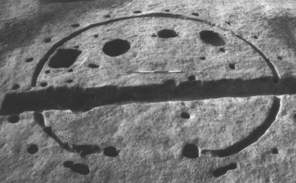
Fig. 2. Late Bronze Age house at Whittlesey. Photo: Cambridge Archaeological Unit

         In a Fenland landscape recognised for its field systems the absence of contemporary boundaries on our site raises interesting questions. Extensive Bronze Age enclosure has been recorded immediately to the north and yet our settlement remained unenclosed. Could it belie different histories of land enclosure and settlement? Elsewhere Bronze Age settlement is superimposed on field systems but here the monuments may have provided a focal point for occupation events, drawing people back to this place. The transformation of space and its occupation (in this case from henge to house) came about via a subtle stratigraphy of inhabitation, tethering people and place.

Mark Knight
Cambridge Archaeological Unit/University of Cambridge

EXCAVATIONS AT MEMBURY, EAST DEVON

In 1986, Mrs Nan Pearce, a member of the Devon Archaeological Society, recognised sherds of Neolithic pottery on the surface of a recently ploughed field near the village of Membury, 8 km north of Axminster in east Devon. Because a find of this nature suggested that ploughing had cut through a previously undisturbed Neolithic context, a trench measuring 2.5 x 2 m was excavated shortly afterwards. This revealed part of a circular feature that could either have been a ditch terminal or a pit, from which substantial amounts of prehistoric pottery were recovered. When these had been conserved, it was possible to reconstruct almost half of a Hembury ware bowl. Thereafter, fieldwalking was carried out in the area revealing localised concentrations of worked flint and several polished axe fragments as well as evidence of apossible Romano-British building in the south-cast corner of the field.
          In 1994 an excavation was planned to relocate and extend the 1986 trench, however the site plan from the original excavation proved to be somewhat inaccurate and the 1986 trench remained illusive. In addition, an unusually dry summer resulted in the field still being under crop when the excavation was due to commence. As a result, an area of only 5 x 10 m could be excavated which revealed a post-medieval hedge line and two shallow pits containing a total of 124 sherds of Romano-British pottery. An earlier geophysical survey had been made of the area in which the 1986 excavation had taken place and in the neighbouring field. The results, which may have been effected by adverse soil conditions, did not reveal any trace of obvious subsoil features.


Excavating the causewayed enclosure ditch at Membury
         In August 1998 limited excavations were conducted in an attempt to finally resolve the nature and extent of Neolithic activity at the site. Since no accurate plans existed to record the location of the 1986 excavation, the 1998 trenches were laid out based on photographs of the earlier excavation. As the topsoil at this location had, on previous occasions, proved extremely difficult to excavate by hand, a mechanical excavator carried out the initial topsoil clearance. The base of the ploughsoil was then cleaned 
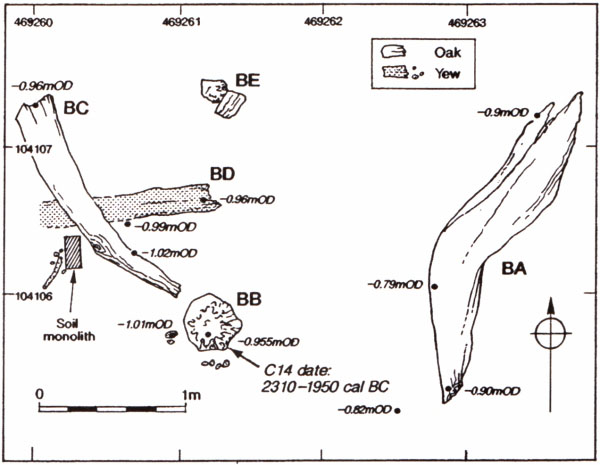
by hand exposing several surviving subsoil features.
         The excavation revealed two distinct phases of activity represented by a group of four Neolithic pits and a large stone filled feature which initially caused great excitement until it was found to be the stone lined flue channel of a Romano-British corndrier. Two, one metre sections through this feature produced 127 sherds (770 g) of pottery, roofing slate and a small assemblage of greensand chert fragments. At first these were thought to be prehistoric chert-working debris that had become residually incorporated within a Roman deposit. However, closer examination revealed several large pieces of greensand chert that had been dressed after they had been built into the lining of the corndrier producing waste flakes similar in appearance to those from prehistoric stone-working.

         The Neolithic pits varied in size from 0.5 m to almost 2 m in diameter although they rarely exceeded 0.25 m in depth. Each contained a variety of worked flint and chert as well as pottery from several plain bowls, characteristic of the South Western regional style. The most impressive group derived from the largest pit which was made up of 304 pieces of worked flint and chert including two leaf arrowheads and a pottery assemblage weighing c. 1500 g. The pottery was recovered from around the edge of the pit, while the two leaf arrowheads were found at the centre. An initial layer of silting which formed around the pottery suggests that the pits may have been left open for some time after artefacts were placed within them.
          While the 1998 excavation had recovered further evidence of Neolithic activity at Membury, it failed to locate the feature that had been discovered in 1986 and had not resolved whether or not a causewayed enclosure was present. At the beginning of this year the field was once again available for excavation for a short period. Initial machine clearance of the topsoil in the area around the 1998 pit group produced numerous features all of which, on subsequent excavation, proved to date from the Roman period. Approximately 30 m downslope of the Neolithic pits, a 25 m length of the ditch was uncovered which followed the contour of the hilltop, running beyond the excavated area to the south but forming a terminal to the north. The exposed ditch described a gentle curve and appeared in plan to be continuous but, when it was initially sectioned at two metre intervals, it was found to have a variety of profiles. There was also at least one example of a terminal between two previously separate ditches that had been dug through. Thus, despite being severely truncated by ploughing, the enclosure ditch retained some evidence of having been originally composed of a series of short ditch segments which were in time united into a single linear feature. When fully excavated two stake-holes (c. 60 mm in diameter) were found in the surviving terminal end of the ditch.
          The fill of the ditch often included densely packed flint nodules. These tended to concentrate on the inner edge of the ditch and may have formed part of the revetting of the inner bank. Finds have not as yet been properly analysed but acidic soil conditions probably account for the absence of any bone, while the three sherds of prehistoric pottery that were recovered were in an extremely delicate condition. Lithic finds, in contrast, are pristine and are represented by both flint and greensand chert. At one location two scrapers and a broken leaf arrowhead were found close to the edge of the ditch. It is possible that these were part of a 'placed deposit' and may even have once been within an organic container.
          Excavation of the ditch terminal revealed a concentration of flint cores. Although one of these, found at the top of the surviving stratigraphy, was a single platform blade core of chalk derived flint, the majority were poorly worked examples from local clay-with-flints deposits. Typically, only 2-3 primary flakes had been removed from each nodule. While this may in isolated examples indicate the 'testing' of a potential raw material, a group of 'tested' nodules such as this strains the credibility of a purely technological interpretation. It may be that this deposit bares comparison with observations made following the excavation of the Lambourn Long Barrow when Wymer noted 'numerous crude cores ... not characteristic of normal Neolithic industries ... were intentionally struck on the site and cast into the make up of the mound' (Wymer 1966).

Martin Tingle

Wymer, J.J. 1966. Excavations of the Lambourn Long Barrow, 1964. Berkshire Archaeological Journal 62, 1-16


LIEUTENANT-GENERAL A.H.L.F. PITT RIVERS
The year 2000 marks the centenary of the death of one of the great pioneers of British Archaeology. The Society is marking this occasion with a celebratory picnic. Mark Bowden provides this short reminder of the life and works of 'The General'.


A scion of the minor aristocracy and squirearchy, Lieutenant-General Augustus Henry Lane Fox Pitt Rivers became a major landowner late in life through a series of fortuitous circumstances, namely the death or disqualification of several intervening heirs. He was born a Lane Fox on the family estate at Bramham, Yorkshire in 1827 and brought up in London. In 1845 he was commissioned into the Grenadier Guards and became a specialist in musketry instruction and the history of firearms. He saw active service briefly in the Crimea but he owed his rapid promotion to the purchase system, and his Postings were mainly of an administrative nature.
          He was inspired by the scientific circles in which he moved after his marriage into the Stanley family, which included Herbert Spencer, Thomas Huxley and John Stuart Mill. Another influence on his mind was probably the Great Exhibition of 1851, and it was at this tine that he became a collector of ethnographic and antiquarian objects. His reading of Darwin's Origin of species on its publication in 1859 marked a turning point in his career. He developed his parallel theory of the 'Evolution of Culture', which was to inform all his later anthropological and archaeological work.

          Fascinated by the raths and promontory forts which he saw in Ireland in the early 1860s and by the hillforts and dyke systems of England, he turned his attention to antiquarian fieldwork at, for instance, Danes' Dyke (North Yorkshire) and Cissbury (Sussex). In the course of this work he began to develop systematic methods of rigorous field investigation and laid the foundations for the serious study of archaeology in Britain. He was also active on the councils and committees of several learned societies.
          His inheritance of large estates in Dorset and Wiltshire in 1880, which enforced the addition of 'Pitt Rivers' to his name, enabled him to increase the intensity of his work; he devoted much of the last twenty years of his life to a series of well recorded large-scale excavations, mainly on his own property, and mainly on later-prehistoric and Romano-British sites such as Wor Barrow, South Lodge, Rotherley, Woodcutts and the Handley Barrows. At the same time he carried out his official duties as Inspector of Ancient Monuments, under the Ancient Monuments Protection Act of 1882. These duties included visiting and surveying sites on the original 'Schedule', and persuading landowners to have other sites placed under the protection of the Act. Because of the restricted scope of the Act the monuments covered were almost exclusively of prehistoric date. The list was also heavily biased towards the megalithic monuments of the highland zone.
          All his anthropological and archaeological work was aimed at the ultimate goal of public education, mainly realised through the creation of two museums, the justly renowned Pitt Rivers in Oxford and the sadly now-defunct Farnham Museum on his own estate in Dorset. (A substantial part of the archaeological collection from Farnham is now on display at the Salisbury and South Wiltshire Museum.) Pitt Rivers was ahead of his time in appreciating that the public needed 'other inducements' to draw them into museums and this was the idea behind the Larmer Grounds, a public pleasure ground equipped for the amusement and entertainment of visitors from near and far. Some of these visitors, at least, were drawn into the nearby museum at Farnham where they might improve their understanding of the history of mankind.
         By founding these major museum collections for the purpose of public education and by publishing the results of his researches in unprecedented detail (in a series of beautifully produced volumes that now fetch hundreds of pounds) he established standards for the future development of the discipline. After his death in 1900, however, the immediately succeeding generation of archaeologists (Heywood Sumner, Crawford and a few others excepted) largely ignored his lead and it was not until the mid-twentieth century that his contribution began to be appreciated by the new coterie of professional academic archaeologists, such as Hawkes, Piggott and Wheeler. His theoretical stance, that social change is analogous to Darwinian evolution, is no longer accepted; the political corollary of this theory, a form of Spencerian social Darwinism with gradualism at its core, is now regarded as extremely right-wing, though in the General's own day it could pass for liberalism. Nevertheless, he has come to be regarded by many as the father of British archaeology, by virtue of his pioneering work in excavation, anthropological archaeology, typology, ancient monument protection and public education.


The Larmer Tree Grounds
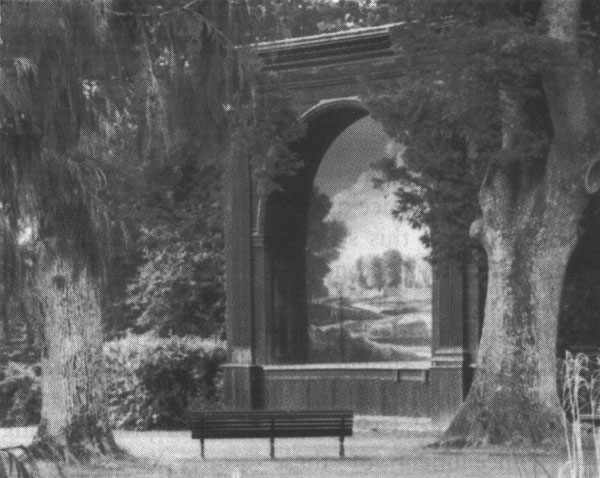
Our millennial picnic is to be held Pitt Rivers' own pleasure gardens on the Rushmore Estate. The Larmer Tree Grounds were laid out in 1880 to provide recreation for the people in the neighbouring towns and villages. The Larmer Tree itself was a wytch-elm which stood, as tradition has it, on the spot where King John used to meet with his huntsman for the Royal Hunt when he stopped at King John's House in Tollard Royal. The original tree still bore leaves as late as 1894 around which time it was replaced by an oak, planted in the centre of the decayed rim.           The origin of the word 'larmer' has been the subject of some debate in the past but seems likely to mean something like a 'rush boundary' (from maere, meaning boundary and laefer being Old English for a rush). Given the position of the tree and surrounding gardens on the top of a chalk hill the presence of rushes in the immediate vicinity seems a little unlikely but the association with a boundary is very plausable as the tree stood within a few paces of the meeting-place of two counties (Wiltshire and Dorset) and three parishes. The name Rushmore was originally spelt Rushmere and maybe of similar derivation.

          The General adorned his gardens with a delightful group of follies: an open-air 'singing theatre' with a Poussin-esque landscape backdrop, a dining-hall, the exotic Indian Rooms, a 'temple', bandstand, and reed-thatched garden houses. Bronze statues of a mounted Ancient British hunter, Japanese storks and a bronze horse, classical busts and urns stood along the grassy walkways and under trees and streams cascaded down flights of stone steps into the ornamental pool in a shady dell. Here the General would entertain one and all with his own brass band on Sundays throughout the summer and regularly opened the gardens for races and sports, and other entertainments. The gardens attracted over 44,000 visitors in 1899 and were still popular for picnics and social events in the 1920s and 30s when modest catering could be provided.
          Sadly, the gardens became somewhat neglected after the Second World War but over the last 20 years they have been lovingly restored by Michael Pitt Rivers, a direct descendent of the General, and are once again a splendid place to spend an afternoon. The gardens are open to the public and available for private functions and a range of events are staged throughout the summer, including the annual Larmer Tree Festival. Sadly Michael Pitt Rivers died at Christmas 1999, but the future of the gardens is secure and one of his last acts was to plant a new Larmer Tree for the new millennium.

Julie Gardiner


STOP PRESS - URGENT NEWS FOR REAL ALE FANS


So far, it seems, that the highlight of this year's Institute of Field Archaeologists' annual conference in Brighton was the trip to Harvey's Brewery in Lewes. Our spies tell us that something of a lock-in occurred and that a large number of people, Society members included, got a little tipsy on some very fine ale. Well guess what folks? Harveys have offered to provide us with some of their very special brew for the Millennium Picnic - you will be able to buy Best from the barrel or treat yourselves to a bottle or two of The General's Tipple - yes, you've guessed it, our very own labelled beer for a special occasion. So we'll see you all at the Larmer Tree on 19 August then?


EXHIBITION OF ARCHAEOLOGICAL PHOTOGRAPHS


Elaine Wakefield has been the full time photographer' with Wessex Archaeology for over 10 years - her photographs have appeared in PPS and PAST on South numerous occasions. The Salisbury and South Wiltshire Museum, the Close, Salisbury, is mounting a temporary exhibition of Elaine's work entitled 'Capturing Time' which opened on 3 March and runs until 3 June.


THE REV. WILLIAM STUKELEY'S LOST MEGALITHIC AVENUE
The Avebury area continues to yield a few surprises


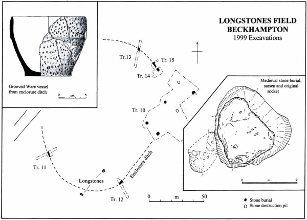
It is difficult to imagine how a megalithic avenue of least 1.5 km long, comprising over 100 stones, some as much as 4 m high, could be lost. But one was, and now, thanks to the records of a diligent antiquarian, it has been rediscovered. The monument in question is the Beckhampton Avenue, leading from the western entrance of the famous Avebury henge monument in Wiltshire. All that is visible above ground today are two substantial standing stones the Longstones - situated in a field 1.2 km to the west of Avebury. These, along with other remnants of the avenue, were first recorded by William Stukeley in 1722, but even at that point the monument was sadly dilapidated (Stukeley 1743). Since Stukeley's day the existence of the avenue has been seriously questioned, a number of scholars arguing that the Longstones formed part of a megalithic setting independent of the Avebuy complex.

          Last summer a team from Leicester, Newport, and Southampton excavated an area adjacent to the Longstones. Aided by a high-resolution geophysical survey undertaken by the Ancient Monuments Laboratory of English Heritage, a sizable area was stripped over the course of the putative avenue. Three pairs of features corresponding to the position of six stones were revealed, running in a line directly towards the Longstones. The stone sockets into which the megaliths had been set were recorded in four instances, their spacing being identical to that of the stones of the West Kennet Avenue leading from the southern entrance of Avebury. However, the most visible traces of this stretch of the avenue took the form of medieval stone burials and post-medieval destruction pits. Three stones (of local sarsen) were found intact and neatly buried in chalk-cut pits. By analogy with similar burials recorded during excavations in Avebury and along the West Kennet Avenue during the 1930s (Smith 1965), the toppling and concealment of these stones (whether for clearance or religious reasons) probably took place in the 14th century. Though not of the immensity of some of the Avebury stones, the three excavated blocks were still of considerable bulk (2.5-3.0 m long). One included stone axe polishing marks on its surface, probably made before it was incorporated in the avenue. Another was riddled with natural perforations, into one of which had been placed a curious assemblage comprising a split cattle long bone and several flint flakes.
          Two shallow pits adjacent to where stones had stood contained spreads of broken and burnt sarsen, along with carbonized straw, and fragments of post-medieval pottery and clay pipe. These relate to a second episode of destruction during the late 17th-early 18th century. Recorded by Stukeley, these 'burning episodes' were undertaken by local farmers who were eager to obtain building material for stone cottages and field walls. A sixth pit contained neither a stone nor signs of burning and may represent a medieval burial pit from which the stone was later removed. Constructed during the late Neolithic (c.2800-2200 BC), the avenue had survived relatively intact until about 700 years ago, then being subject to four centuries of depredation. Without Stukeley's records we would not have suspected its existence.
          There is another dimension to this story. We had begun work in Longstones Field in order to investigate a cropmark enclosure, first spotted from the air by the RCHME in 1997. The cropmark described an oval enclosure 140 x 100 m across enclosing one of the Longstones. At first sight it bore a resemblance to those observed marking the late Neolithic palisaded enclosures at West Kennet (Whittle 1997). Excavation showed it to comprise a shallow, flat-bottomed ditch (not a palisade), which we believe had originally been accompanied by an internal bank. The ditch looked 'gang-dug' and this, together with a limited finds assemblage, suggests a ditch circuit had been Neolithic date. The entire ditch circuit had been levelled at some stage, perhaps as early as the late Neolithic, and possibly at the time when the avenue was constructed. The avenue runs through the enclosure, entering via a wide entrance gap on the east and running over the ditch circuit as it leaves on the south-west. We suspect the enclosure pre-dates the avenue, but by how long will remain uncertain until radiocarbon dates are obtained. Though different in kind, it is over-looked by the famous earlier Neolithic causewayed enclosure on Windmill Hill (Whittle et al. 1999).
          Further excavation is planned this summer. Amongst a series of questions, we hope to determine whether the avenue continues beyond the Longstones as Stukeley suggested, resolve the relationship between the avenue and enclosure, and explore the interior of the latter. We are perfectly prepared to be surprised again.

Mark Gillings
(School of Archaeological Studies, University of Leicester)

Joshua Pollard
(University of Wales College, Newport)

Dave Wheatley
(Department of Archaeology, University of Southampton)

Smith, I.F. 1965. Windmill Hill and Avebury: excavations by Alexander Keiller 1925-1939. Oxford: Clarendon Press
Stukeley, W. 1743. Abury: a Temple of the British Druids. London
Whittle, A. 1997. Sacred Mound, Holy Rings: Silbury Hill and the West Kennet palisade enclosures: a later Neolithic complex in north Wiltshire. Oxford: Oxbow Books
Whittle, A., Pollard, J. & Grigson, C. 1999. The Harmony of Symbols: the Windmill Hill causewayed enclosure, Wiltshire. Oxford: Oxbow Books


MILLENNIUM PICNIC

Come on, you can't put it off any longer. Book now via Tessa Machling for the event of the millennium. The Millennium picnic is at the Larmer Tree Gardens, Tollard Royal, Wiltshire on Saturday 19 August 2000 from 12.00 noon to 7.00 pm. It's a full afternoon's entertainment plus lunch and cream tea. Prices are £25 per head for adults, £10 ages 4-14, under 4s free. Accommodation details are available.


SOCIETY MERCHANDISE

The following are all available from
         Julie Gardiner,
         Wessex Archaeology,
         Portway House,
         Old Sarum Park,
         Salisbury SP4 6EB

j.gardiner@wessexarch.co.uk


All prices include p&p and all merchandise bears the Society logo.

T-shirts (one size) £8 and Sweatshirts (one size) £18 available in red, green, gold, grey and light blue (please state choice of colours in order of preference).

Exclusive silver jewellery: earrings (stud or clip): £26; brooch/pendant: £28; cufflinks: £32

Enamel studs: £1.50

Ties: silk £14.95; polyester: £7.95

Cheques should be made out to the Prehistoric Society (sorry, no credit cards).


THE HEART OF NEOLITHIC ORKNEY: SCOTLAND'S NEW WORLD HERITAGE SITE


Skara Brae
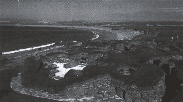
Skara Brae. Photo: Historic Scotland Crown Copyright Reserved
In December 1999 The Heart of Neolithic Orkney was inscribed by the United Nations Educational, Scientific and Cultural Organisation (UNESCO) as a World Heritage Site. It was officially launched by the First Minister, Donald Dewar, on 24 March 2000. The First Minister and the Deputy First Minister, Jim Wallace also unveiled a plaque to mark the World Heritage Site. Patrick Ashmore of Historic Scotland took the lead in preparing the successful nomination, which was submitted in 1998. The Heart of Neolithic Orkney joins two other Scottish Sites on the List: St Kilda accepted as a natural site in 1987, and the Old and New Towns of Edinburgh, a cultural site approved in 1995. The Heart of Neolithic Orkney is therefore the first archaeological site to be honoured in this way in Scotland.


What is The Heart of Neolithic Orkney and why is it so important?
The Heart of Neolithic Orkney has been applied to Maes Howe, Skara Brae, the Stones of Stenness (with the Watch Stone and Barnhouse Stone), and the Ring of Brogar together with adjacent standing stones and burial mounds. The first three of these monuments were built before, and used before and during, the first half of the 3rd millennium BC. The Ring of Brogar took over their pre-eminent role around the middle of the 3rd millennium BC. All these monuments are exceptionally fine and authentic relics of the period when, world-wide, great civilisations started to arise. As such they have been recognised by UNESCO as outstanding testimony to the cultural achievements of the Neolithic peoples of northern Europe.

What does World Heritage Status mean?
World Heritage status does not add any controls to those which already exist and the Site is already in the care of Scottish Ministers, through Historic Scotland. Its geographically discrete components have inner and outer buffer zones (defined on the basis of a range of extant cultural and natural designations which are recognised in the planning process). World Heritage Site status is therefore a key material factor which must be taken into account by Orkney Islands Council in making planning decisions and Historic Scotland in its management of the monuments included in the Site.
          With advice from a local Steering Group, Historic Scotland is finalising a Management Plan which provides a framework for an integrated and consensual approach to dealing with the issues faced by Historic Scotland and other bodies and groups in Orkney. A Consultation Group is being set up for wider public consultation. Jane Downes of the Orkney College and Orkney Archaeological Trust will be setting up an Archaeological and Historical Research Co-ordination Committee. Historic Scotland will regularly monitor the condition of the Site and contribute reports to UNESCO which update information about The Heart of Neolithic Orkney and record changing circumstances and state of conservation.

What are the problems facing The Heart of Neolithic Orkney?
Routine maintenance of the Site is the responsibility of Historic Scotland, but there are wider issues which need to be addressed in the buffer zones, particularly visitor and traffic management and, at Skara Brae, the threat of coastal erosion. In the buffer zones archaeological sites may suffer from rabbit disturbance, cattle poaching and ploughing.

How can I find out more?
The following documents are available from Historic Scotland, Longmore House, Salisbury Place, Edinburgh, EH9 1SH:

· a free colour leaflet summarising the Management Plan Proposals - send a SAE to Duncan McKendrick, Room G49
· the reprinted, colour Nomination document is available for £10.50 including p&p from Cath Mackenzie, Room G1.

          Inquiries can be directed to Dr Sally Foster who is taking the lead in finalisation of the Management Plan.

sallyfoster@scotland.gov.uk


Sally Foster


AN EXCITING NEW EBA DAGGER GRAVE FROM FIFE


Things may be rough for the Grundy family these days, but for the 4000-year-old inhabitants of Rameldry Farm in Fife, life was good. On 21 February, ploughing exposed the capstone of a cist containing a crouched adult inhumation, the remains of a sheathed dagger and six V-perforated buttons. Mr Smith, the farmer, contacted Historic Scotland straight away, and through the kind offices of the Balbirnie Estates Headland Archaeology Ltd excavated immediately. The bones were not in good condition but there should be enough organic material from the cist for a C14 date.
Fig 1
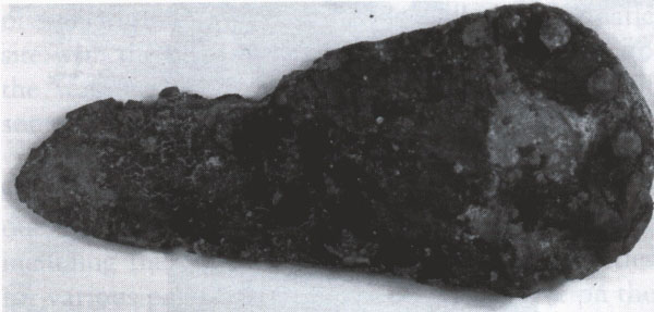
Fig. 1. The Dagger with traces of a sheath

         The dagger belongs to the general family of flat riveted blades which form a distinctive component of the range of EBA metalwork following the transition to full bronze metallurgy at the end of the 3rd millennium cal BC. The blade is around 130 mm long. While further details will only emerge following conservation, the dagger has clearly had an arrangement of 5 peg rivets set symmetrically about the heel. Traces of an organic hilt plate - possibly of horn - survive and this appears to have been embellished with tiny metal pins. Owing to the extent of corrosion, their overall design remains unclear for the moment, but at least one row seems likely to have followed the semicircular outline of the hilt recess. The tongue-shaped blade retains traces of a sheath, possibly of haired skin.

Fig 2
Fig. 2. The decorated button
          The buttons, 42-51 mm in diameter, were found in the chest area. Five are of jet or a similar material, and the sixth - bronze-coloured, perhaps recalling the bronze-covered buttons of Continental Europe - may be of stone. One of the 'jet' buttons has a crudely-incised cross design on its upper surface, and a circumferential edge groove. Traces survive of a white material in the design, similar to that seen on other jet jewellery (and indeed some beakers), and thought to be polishing material for jet, left in for decorative effect. Uniquely, however, the button also has a zigzag pattern in each arm of the cross, which seems to have been achieved through differential polishing.

          Although buttons are found with both male and female inhumations, in Scotland (at least) daggers appear to have been associated with males, particularly senior males (see A. Henshall, Scottish dagger graves, in J Coles & D D A Simpson, eds, Studies in Ancient Europe, Leicester, 1968, 173-95). Work by a team of specialists - on material identification and sourcing, on pollen, on the bones, etc. - will now seek to reveal more about this intriguing find.

Stephen Carter, Trevor Cowie and Alison Sheridan

Henshall, A. 1968. Scottish dagger graves. In J Coles & D D A Simpson (eds), Studies in Ancient Europe, 173-95. Leicester.


THE NINTH EUROPA LECTURE

The Ninth Europa Lecture by Professor John Coles, will be delivered at the Society of Antiquaries after the AGM on Wednesday 31 May 2000 at 5.00 pm. The lecture is entitled 'Prehistory Writ Plain: wetland archaeology and the wide world' and will be followed by a wine reception.


AXEHEAD INFORMATION REQUESTED


I recently published a note on the flint axehead illustrated here (Saville 1999), which was found about five years ago near Montrose in Angus, eastern Scotland. It is a fine, but relatively small, example of a particular type of all-over-polished flint axehead, which is often of above average length, has side facets, and a symmetrical form with near-straight tapering edges and a semi-circular butt. The most distinctive attributes of the type, however, are the very high-gloss finish and the use of flint with fossil inculsions and/or of unusual colour, often variegated or marbled as here.
Polished flint axehead
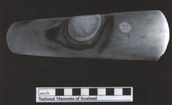
Polished flint axehead from near Montrose, Angus (photo: NMS)

         There are some twelve or so examples of these axeheads known from Scotland, mostly from near the east coast (Sheridan 1992), and there have been occasional reports of similar axeheads from eastern England. I am currently attempting to collate this information and would be delighted to hear from any museum curators or private collectors who have examples of these axeheads, or from anyone who can direct me to any published or unpublished finds. Please contact me at: Department of Archaeology, National Museums of Scotland, Chambers Street, Edinburgh EHI 1JF

as@nms.ac.uk


Saville, A. 1999. An exceptional polished flint axe-head from Bolshan Hill, near Montrose, Angus. Tayside & Fife Archaeological Journal 5, 1-6
Sheridan, A. 1992. Scottish stone axeheads: some new work and recent discoveries. In N. Sharples and A. Sheridan (eds), Vessels for the Ancestors: essays on the Neolithic of Britain and Ireland in honour of Audrey Henshall, 194-212

Alan Saville


THE MILLENNIUM: AND HOW WE AVOIDED IT (NEARLY)
So where were you for the Millennium? - personally I was standing on a bench in the drizzle in my back garden, with a glass of champagne, watching five different firework displays going off simultaneously. Val Moore, on the other hand, was having a wonderful time in Cyprus, and has sent me a few highlights...


Fig 1.
Fig. 1. One of the better surviving examples at the Tombs of the Kings, Pafos (Photo: Val Moore)

Leaving the snow lying across the New Forest we ventured to Cyprus - the birthplace of Aphrodite. The car we hired seemed to be powered by a couple of hamsters on a wheel but we were hopeful it would see us around the island as we ventured out and about from our hotel just north of Pafos in search of prehistoric sites.
          First stop, Tombs of the Kings, Pafos. Only eight of the tombs are mentioned in the guidebook but there were actually over 100 in the area. Many have been destroyed - used as family tombs by the nobles of the Ptolemies between 300 BC and AD 300 they were later used as dwellings and later still many were lost to sandstone quarrying. Those that do remain are cut into the rock. Some are now just niches cut into the wall, others consisting of full rooms with wall niches (Fig. 1), and older ones have sculpted colonnades. One had some round, Doric columns and others of square, undressed stone all within the same tomb structure. Traces of frescos can still be seen.
          Along the coast, but still intervisible with the sea at the foothills of the Troodos Mountains, is Khirokitia. A multi-occupation site of the aceramic Neolithic period (7500-5200 BC), it was built up a hillside. French excavations in 1998 found the entrance to the village which is half-way up the hill. A curious feature was that the village appeared to have a wall running through it - some 2.5 m thick; 3 m high in places and 185 m long - that had been interpreted, prior to the French excavations, as possibly a raised walkway wide enough for pack animals. The recent excavations suggest that it was originally an outer wall - but the village developed 'outside' this and a new wall and entrance had to be constructed. The walkways around the houses, and indeed into the village, seem to be just one person wide. The excavation plan in our guidebook showed that only 10%, if that, of the site has been uncovered. As one comes up the hill, the larger the round-house remains become. There are various types of internal 'fittings'. Some have steps, low walls, and platforms, usually trapezoidal, that appear to divide the space for work and rest areas. Some have large stone piers (which seem to get in the way rather) that may well have supported an upper floor - it is believed that the roofs were flat. Burials have been found under the floors, though not a great many considering the time the site was occupied and it left us wondering if these were ritual burials for a purpose - especially as in one instance there were 29 newborn babies out of a total of something like 35 deposits! It really is a dramatic site with the remains cascading down the hillside to the watercourse below and the reconstructions of some of the buildings.

         The main museum in Pafos is housed in a large shed, although it looks more imposing from the outside. It does have some interesting things, though, including the 1st century pottery hot water bottles for various parts of the body. Each is concave on the underside with the front aptly showing the part of the limb it is to go on. There were some wonderful Neolithic stylised crosses, mostly female, with extremely elongated necks and odd little hands. You could say that the style and layout of the museum is very much on a 'themed' basis: if it looks similar put it in the same case! Some true provenances would have been helpful, as would a guide book, especially as some of the numbers have been shifted around on the exhibits...
         The museum did, however, have a map of the area which lead us to the site at Lemba, just a stones throw from our hotel which, although not marked from the main road, is signposted once you are off the main road! Less than 1 km from the sea, the site is set on a slight promontory. As with the Khirokitia site some reconstruction has been done (Fig. 2) and one of the reconstructed huts was much bigger than we had seen before. The settlement was destroyed in 2500 BC with many objects left in place - some of them are in the museum in Pafos.
Fig 2.
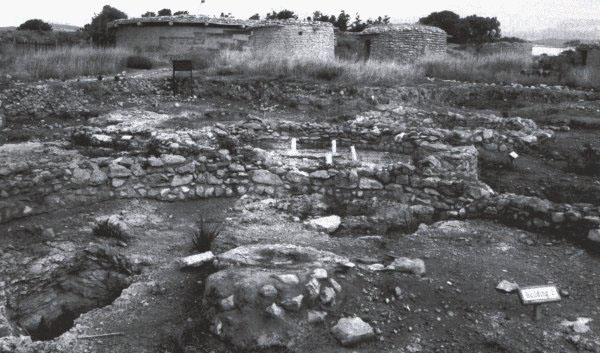
Fig. 2. The site at Lemba with the reconstructed huts in the background (Photo: Val Moore)

         One of the houses (labelled house 2 on Fig. 2) had contained many storage vessels while graves under the floors were linked to the living area by small holes to allow contact between the living and the dead - the holes may have been for liquid offerings to the ancestors. Other graves in the open area beyond the houses were marked by depressions with capstones over the simple pits. Usually a single child or adult was buried with a few grave goods. Two buildings in the excavation area probably served as kitchens as many animal bones were found. Each house was equipped with a large central platform, and experiments have shown that these provided heat throughout their surfaces - much as an Aga stove.
          We tried to find the nearby site of Kissonerga and finally succeeded - again it was only signposted once we were off the main road. Its location which, like the others we saw, is on a spur overlooking the sea with the Skotinis river to one side. The site is now actually circled by a banana plantation - the bananas being protected in blue plastic bin liners! At the current time the site is being prepared to be opened to the public - but it is open anyway so we strolled in. Kissongerga has the longest sequence of occupation in Cyprus (6000-2300 BC) and is one of the largest settlements, extending for some 12 ha. There have been some extraordinarily well preserved finds including the famous pottery model of a house (now in the Nicosia museum), white stone tools, pottery figurines and bowls, in situ remains of the lime plastered floors and a cobbled road/trackway. The Red House (so called because of its red-painted floors and red plaster wall inlays) is the largest prehistoric building in Cyprus.
          The Nicosia Museum is a truly wonderful place! We went into the first room and immediately found the finds from Kissonerga which include the model of the round-house. I think model may be an overdramatic title as the thing is more like a pottery bowl, with the bottom narrower than the top. Also from Kissonerga is a very large pot standing about 1 m high. They have just one piece of rock art (had to get that in !) which is described as a figure - well, it has a square head and quite a long neck.
          Horses and cattle were introduced during the Early Bronze Age (2500-1900 BC). In the Bronze Age room were a couple of well known models - one ploughing scene with two pairs of oxen pulling the ploughs. The oxen have incredibly large horns. Surprisingly, given the sophistication of the pottery and other models, the clay figures are very roughly done, with only rudimentary noses and ears. In the next room is a sample of the 2000 figurines found around the alter at the sanctury of Ayia Irimi in north-west Cyprus (1200-600 BC). Of all these figures only two were female, indicating the worship of a warrior god in the form of a centaur or minotaur. The figurines go from lifesize down to just 20 cm or so in height and are mostly male figures with some animals, a few chariots with four horses, and a couple of centaurs. Two figure appear to have their arms in a sling, various style of clothing, headgear, and hair dressing are indicated and some are carrying animals, possibly as offerings.
          On Christmas Day we went for a scenic drive to the north of the island to look for another prehistoric island off the north coast - unfortunately is was on the Turkish side and out of bounds. And New Year's Eve? ... we joined our fellow guests for a gala buffet dinner. The hotel staff were in historical (or should that be hysterical?) costume - the barmen in shiny white calf-length togas and their usual shoes and socks. We arrived over an hour late for the meal (the queues !) but still in time to eat. It was chaotic and far too crowded with elbows-in everywhere. Luckily, we had come for the archaeology, not the millennium experience!

Val Moore


ARCHAEOLINK PREHISTORIC PARK

The Archaeolink Prehistoric Park in Aberdeenshire, which opened in June 1997, is a centre for the interpretation of the prehistory of the north-east of Scotland. The centre building houses a film introduction to Scottish prehistory and a series of computer-generated interactive displays. Outside there is a range of reconstructions, a prehistoric tree trail and a 'real' prehistoric settlement on Berryhill - a late Bronze Age/Iron Age enclosed hilltop settlement with outlying open settlement partially excavated in 1999. A second season of excavation is planned for August 2000 and volunteers are welcome. The site is particularly appropriate for illustrating continuity of use of a relatively dry, level low hill in what, until recently, was quite wet lower ground. Late Neolithic/Bronze Age flintworking on the hill probably indicates intermittent, pre-settlement, use of the hill which was also reused in the post-medieval/early modern period for a very small croft.
          Throughout the park the emphasis is on scholarship, interpreted through living history, drama, and storytelling. Adults and children are encouraged to touch, feel, smell, and try things for themselves.
          Among the highlights of the park are a Mesolithic settlement where a log boat was made during 1999; a small henge has been built; ochre and charcoal paints were made and used to decorate the henge posts with late Neolithic/early Bronze Age motifs. In 1998 part of a Roman marching camp was constructed - the only one ever to have received planning permission! The camp provides a link with the major Agricolan battle of Mons Graupius of AD 83, one possible site of which is just 2 km away from Archaeolink. The most fully developed reconstruction is the Iron Age farm and ritual area. The house, based on an excavation at Moneymusk, is 10 m in diameter with wattle walls, thickly insulated with clay, and a thatched roof. A half loft is built into the roof space around the perimeter of the building which would have provided an additional sleeping area as well as storage space. Recently a recumbent stone circle has been erected and future projects include the creation of a bronze working area (as soon as the snow melts!).
          Archaeolink is at Oyne, Insch, Aberdeenshire AB52 6QP and is open April-end October, 10 am to 5 pm every day. For more information ring 01464 851500 or visit the web site on

www.archaeolink.co.uk.


Hilary Murray


REFLECTIONS FROM THE SECRETARY
(Postcards from the edge? - ed.)

Retirement from Council as Secretary in May provides the opportunity to reflect on how the Society has changed over the past decade. The Society is often viewed as a traditionalist and relatively slow moving organisation but it has tried to move with the times whilst maintaining its high standard of publications and events.
          It was a great surprise in 1990 to receive a letter of invitation to be nominated as a Council Member; what did it mean? Having joined the Society as an undergraduate in Manchester (Dave Coombs promoting the idea as a bargain - '£5 for this' he said, holding up the latest copy of the Proceedings - who was I to disagree?) and having received grants for research on the Solway Plain, I thought it was time to accept the offer and give something back. Little did I know it would be 10 years (and six of those as Secretary)!
          This may sound like a prison sentence but it was quite the opposite; the freedom to meet people from all walks of life as well as all branches of archaeology has been the greatest bonus. There were, however, questions which needed answering and it was only by going on the Study Tours and attending lectures that one was able to gauge the 'audience'. As someone who resents paying huge sums of money to see sites I always wondered who the Study Tours were aimed at? They seemed to take up an enormous part of the Society's administrative time and yet only 2% of the Society's membership benefited.
          So in 1994 I coughed up the necessary money for the Isle of Man tour; immediately it became clear that these tours were much more than taking 30-40 people around a region's archaeological sites. They are, in fact, a form of cultural visit which attracts attention to the region (even TV coverage in the Isle of Man case) and are, therefore, beneficial to the area in raising awareness but also for the Society in keeping and attracting members. Those on the tours always enjoy themselves and are always treated to the best hospitality and excellent tour guides.
          The Overseas Tours have changed, in that Andante Travels Ltd have taken over handling the administrative and logistical burden. This leaves the Society time to consider selection of which archaeological sites to visit and finding the appropriate host in the country to be toured. It releases an enormous resource for concentrating on meeting some of the Society's fundamental challenges (balancing income and expenditure and maintaining a loyal membership).
          The innovation of a student place for each of the tours (UK and Overseas) has been important and this leads on to a major concern for the Society over the past decade. The profile of membership is such that those with leisure time and money are usually nearer retirement age and thus their needs have to be catered for. The development of the lecture programme, mainly by Dave McOmish, into a more broad geographical spread across the UK has provided more events for members to attend. Equally the Research Weekends are almost invariably a sell-out and it seems that these 2-3 day tours (lectures and field visits) provide exactly what the membership wants. However, the younger element is still not fully catered for; student numbers have doubled in the last three years but we still need to attract more young professionals. The development of the website (www.britarch.ac.uk/cba/prehist) by Tessa Machling and Andrew Garner has helped with the student population. With these factors in mind we initiated the PhD Research Day now in its fourth year. After a slow start (in terms of audience participation) it has developed at Sheffield into a two-day event with the first day specifically for PhD students presenting their latest research.
          The generosity of John Coles in setting up the John and Bryony Coles Award - to fund travel for research - will encourage student membership. This award came as a welcome but great surprise. Now in its third year the applications have been increasing and reports from these students should soon be appearing in the pages of PAST.
          One failure though, has been the lack of a student only Research Weekend; Dave McOmish and I have often said how much fun it would be to take three minibuses of students from all quarters of the Country on a field trip - staying in youth hostels and camping (to reduce costs). It is only time and other commitments that has prevented this happening; anyone reading this and willing to organise it can count on me to be a driver!
          One of the trends in archaeology in the past decade has been for professionals to be 'generalists' - in that I mean people who can run projects on all periods from industrial archaeology sites to the Palaeolithic. This has meant that the need for the Prehistoric Society may have been seen as less significant - but the production of the Proceedings and PAST is thus more important as they are essential reading material for a wider audience. Therefore it is important for the Society to attract the non-specialist and capitalise on the current increase in interest (generated from television programmes) in archaeology.
          The attention on what the members want takes up perhaps 90% of the Society's business. The biggest change since I joined is that we now know how many members there are, how much they are paying, and when they last paid. This may seem somewhat mundane and routine but it has taken three full years to sort out the membership database and track who has paid for what. This is major achievement and could not have happened without immense patience and effort by Tessa Machling. It is always painful to have to write to longstanding members to say that if you have not paid by a certain date your membership will have lapsed. The Society had to do this because it became clear in the first year of sorting out the membership list that 25% of members were receiving all the benefits but were either paying nothing or paying the subscription rate of ten years ago. (Some were paying twice!) In most cases this was an oversight and not deliberate - we all have to be reminded to a) pay and b) what the new rate is, or we leave the standing order alone; also if the Society keeps sending the Proceedings free who is going to complain? So, take a look at the income from subscriptions for 1999 and compare this for 1998 and 1997 (in the accounts) and you will see a positive trend upwards. (Remember that in 1998 the financial year was 14 months long as we changed it to coincide with the calendar and subscription year).
          Thus 1800 paying members bring in more than 2000 members with 25% not paying full rates. The aim is now to raise the numbers to 2000 (at least) and thus maintain the size and quality of the Proceedings and PAST and the ambitious lecture programme. Our new promotional leaflet is already bearing fruit.
          Having served under four Presidents (Thurstan Shaw, David Harris, Tim Champion, and now Paul Mellars) it is clear they all have one thing in common - a deep concern for the Society's future and a passion for prehistory. Each had/have their on way of showing it but the trends outlined above, if continued, will maintain the Society for many years to come. The Society is neither rich nor poor but it is stable - being financially stable is perhaps is greatest concern and without our Treasurer's (Maria Mayall) firm grip (so often behind the scenes) on the Accounts we would not be in such good shape.
          The Society has tried to have a voice in the Conservation debate and in most cases has done quietly and effectively. Naturally it has been Stonehenge that has taken the limelight and will continue to do so for the next decade in terms of its long term preservation and presentation, As Secretary I became very involved in understanding the issues at Stonehenge and there can be few greater pleasures than walking the Stonehenge bowl with knowledgeable colleagues on a fine summer's day. The Society made its views known to the appropriate authorities and published these in PAST. There is no doubt that it will be asked to do so again and it is up to all members to contribute to the conservation debate.
          Finally I owe a huge debt of gratitude to those who help to educate me in the ways of the Society - they are too many to mention by name. I will remember my period of office with great memories be it in the committee rooms or on the tops of mountains in Scotland, England and Wales.

Bob Bewley

(I'm sure all members will join me in voting a huge round of thanks to Bob for all his hard work on behalf of the Society over the past decade - ed.)


RUN OF PPS BACK NUMBERS FOR SALE

A rare run of back numbers of PPSEA/PPS back numbers from 1908-1994 is for sale. Volumes for 1908-1956 are bound in 14 volumes, grey cloth, with 1956-94 in original wrappers. All in very good to fine condition.
Please contact
         Anne Rockall or Allan Dollery,
         Kingswood Books,
         17 Wick Rd,
         Milborne Port,
         Sherborne,
         Dorset DT9 5BT
         tel/fax 01963 250280.
The vendors are keen that the run should go to a good home - preferably a PS member.


CONFERENCES

Iron Age Research Student Seminars: 3.6.00-4.6.00
The third Iron Age Research Student Seminar provides a forum through which students can present papers an informal atmosphere. The conference will be hosted by the School of Archaeological Studies at Leicester University. It is intended primarily for researchers engaged in existing postgraduate work, hovever the IARSS welcomes anybody who has an interest in current Iron Age Research. The following day will be an optional trip to one of the local Iron Age spots with an informal picnic. Further details from
         Jodie Humphrey,
         School of Archaeological Studies,
         University of Leicester,
         University Rd,
         Leicester
tel 0116 2522603

jlh11@leicester.ac.uk


The Prehistoric Archaeology of Kent: recent discoveries: 3.6.00
Developer-funded excavations throughout Kent have begun to illuminate the extraordinary - and hitherto poorly appreciated - richness and complexity of the prehistoric archaeology of this county. This day, organised by the Prehistoric Society, will review recent results and their significance, bringing together a range of individuals and organisations working in the county. Details from Tessa Machling.

Islands: dream and reality: 29.6.00-2.7.00
The 2nd international 'Small Islands' conference will be hosted by the Centre for Manx Studies at Douglas, Isle of Man. Themes include identity; perception & myth; migration; causes & effects; islands as utopia & dystopia. Details from
         Dr Fenella Bazin,
         Centre for Manx Studies,
         6 Kingswood Drive,
         Douglas IM13 3LX
tel 01624 6730474

fenella.bazin@liverpool.ac.uk


Tall Stories? Broch studies, past, present & future: 7.7.00-10.7.00
A broch conference, to be held in Shetland, looking at issues surrounding these inspirational monuments. The conference will be linked to excavations currently underway at Old Scatness, with field visits including Mousa. Details from
         Biddy Simpson,
         Shetland Amenity Trust,
         22-4 North Rd,
         Lerwick,
         Shetland ZE1 0NQ,
tel 01595 694688

shetamenity.trust@zetnet.co.uk


Lithic Studies in the year 2000: 8.9.00-11.9.00
This conference, organised by the Lithic Studies Society, will be held at the National Museum & Gallery, Cardiff. Sessions include behaviour and cognition in the Lower & Middle Palaeolithic; lithics in transition; lithics in the Bronze Age & later periods; raw material studies; mobility, contexts, range & territory; use wear & residues. Further details from
         Elizabeth Walker,
         Hon Secretary,
         Lithic Studies Society,
         National Museum & Gallery,
         Cathays Park,
         Cardiff CF10 3NP,
tel 02920 573274, email

Elizabeth.Walker@nmgw.ac.uk


European Association of Archaeologists: 10.9.00-17.9.00
The 6th annual meeting of the EAA will take place in Lisbon, sponsored by the Portuguese Institute of Archaeology. Further details from the
         EAA 2000 Meeting Secretariat,
         Instituto Portuges de Arqueologia,
         Avenida da India 136,
         1300-300 Lisboa,
         Portugal

eaa2000@ipa.min-cultura.pt
www.ipa.min-cultura.pt/eaa2000


Home Page The Prehistoric Society Home Page