| Homepage | Timeline | Maps | A-Z index | Learning |
Qasr Ibrim (Primis)
(22°39' N 32°00'E)
Qasr Ibrim (Arabic: castle of Ibrim), site in Lower Nubia. Occupied from Pharaonic (New Kingdom?) till Ottoman times. The strategic site is fortified. It was within the area controlled by the Napatan empire: there are remains of a temple of Taharqo. At some later periods it became the border fortres: under Augustus there was a Roman garrison (under the prefect Gaius Petronius), but the place soon returned to Meroitic control. It was an important centre in the period of the X-Group (about 350-550 AD), and then at the time of the independent Christian kingdoms of Nubia: there is a Christian cathedral, with burials of bishops (compare the stela of a bishop). The site is the find spot of many medieval Nubian, Greek, Arabic and Ottoman Turkish manuscripts on parchment and paper (one of the largest and latest papyrus scrolls is a magnificent decree now in the Nubia Museum, Aswan).
The Egypt Exploration Society has been conducting regular excavations at the site since 1959, and these continue to rescue as much information from the site as possible. The area of the cemeteries is today flooded by the lake Nasser, while the settlement site, which mainly covers raised ground, is still accessible, though parts of the impressive fortifications have recently been damaged by changes in the water level and erosion from tourism.
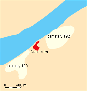
pottery | stela of Christian bishop | tomb 192.2
bibliography: