Ελληνικά

under the aegis of the Canadian Institute in Greece and the Hellenic Ministry of Culture
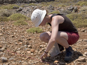
Collection within a 5 sq.m vacuum circle. Photograph by J. Conolly.
The second stage of our intensive surface survey involved collecting a systematic sample of artifacts from ca.50 different locations across the island. A particular emphasis was placed on exploring prehistoric scatters in an attempt to mitigate the lower diagnostic visibility of these earlier periods in the tractwalking record. Such stage-two collections were organised on a 10x10m grid, with the centre of each grid square defined by a four-digit UTM coordinate pair (in a multiple of five, e.g. 3456, 0125). Not only did this simplify recording, but because it located artefacts to within ca. 10m of their actual position, it also integrated easily with our stage-one tractwalking collection and allows us to compare surface collection data with various digital raster datasets (such as the Digital Elevation Model and multispectral satellite coverages). A full mapping of ASP's grid square units is available from the downloads page.
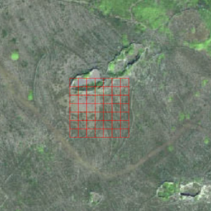
A set of 10m collection squares at the location known as grid 2. Image by A. Bevan (background satellite image is copyright Digital Globe, 2004).
Within each section of the grid, a circular area of 5 sq.m was completely vacuumed of cultural material over a timed 5-minute observation period, and any further diagnostics in the remainder of the square were also collected. Overall, some 1,700 squares were collected (about a 1% sample of the island's entire extent), providing a more detailed impression of the size and function of the numerous prehistoric activity areas observed across the island.