Ελληνικά

under the aegis of the Canadian Institute in Greece and the Hellenic Ministry of Culture
Geoarchaeology offers a suite of approaches for understanding: a) the major changes that have occurred to the island environment over the Holocene, b) the smaller-scale post-depositonal processes affecting the surface archaeological record, and c) the range of natural resources available to the island's inhabitants, including how these have been modified by human intervention. Ruth Siddall (UCL) has concentrated on a detailed re-mapping of the island's structural geology: in many respects, Antikythera represents a classic section of southern Greek geology, exposing carbonate rocks of the Cretaceous-Palaeogene Gavrovo-Tripolitza Unit (rudist and nummulitic limestones) and its overlying flysch (sandstone). Post-Alpine Neogene extensional tectonics produced sedimentary basins collecting shallow marine and shore facies rocks, in places accumulating marls and conglomerates hundreds of metres thick. Her work is crucial for understanding both the potential raw material sources and the major tectonic changes to the landscape that have affected erosion and hydrology.
Charles Frederick (University of Texas at Austin and independent) specialises in human-modified, semi-arid environemnts and has been documenting the locational characteristics of prehistoric activity areas and the multiple phases of the island's terrace systems. In particular, variability of soil characteristics across different parts of the island and over different phases of human exploitation is something that we have identified as a critical research area. We have collected soil samples and performed water inlfiltration tests at ca.100 different localities, in order to quantify variability in soil acidity, nutrient content, moisture retention properties etc.
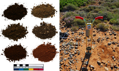
Samples of different soils from Antikythera and an example of a test for water infiltration. Photographs by S. Killam, J. ONeill and S. ONeill.
Alongside erosional processes, another factor actively encouraging relatively short-term changes in the island's soil fertility is the construction, maintenance, abandonment and re-use of terrace systems. As part of a dedicated sub-project focused on this issue, we have been describing promising terrace exposures and sampling their soil deposits for laboratory characterisation by granulometry, organic matter content, magnetic susceptibility and total phosphorous analyses. Samples from stratified sediments within the tread fill are also subject to either radiocarbon or optically stimulated luminescence dating in order to date when these deposits were created. In combination, these methods help clarify the manner in which terraces were constructed on the island and how the deposits have been transformed by agricultural use.
Digital techniques are also an important component in our geoarchaeological study. For example, we use Differential GPS equipment for the collection of high resolution topographic data for many of our stage two grid collection areas, allowing us to develop a more subtle understanding of the impact of topographic variability and small-scale hydrology on artefact spatial patterning. A GIS-led model of hydrology facilitates further erosion modelling of soil loss and accumulation regimes across the entire island. ASTER SWIR imagery (sharpened by a Quickbird panchromatic band) has also been used successfully to assist Siddall's field mapping of the island’s major bedrock and soil groups.