CHAPTER 2
PHYSICO-CHEMICAL CHARACTERISTICS OF WATER BODIES
The effect of light, temperature, season and latitude
Light penetration
All direct solar radiation enters water bodies through the air-water interface. A significant amount of light is reflected from the water surface, especially where the Sun’s rays strike the surface at a narrow angle. Of the light that enters water bodies, some is scattered upwards, often giving a characteristic colour to the water when viewed from land because of differential absorption of wavelengths [2.1.]. Absorption of solar energy results in the generation of heat.
Not all wavelengths of light penetrate to the same extent, blue light passing furthest into the water. However, light only penetrates for a few hundred metres in the clearest natural waters and only a few centimetres in the least clear. This means that heating by absorption of solar radiation will occur in a narrow band at the surface of oceans and lakes and photochemical reactions involving solar radiation are confined to these very surface waters. This photic zone makes up a tiny fraction of the volume of water in oceans, and only a small fraction in many lakes, most of the water column being in darkness, except for luminescence generated by some organisms.
Heating of water in oceans and some lakes also results from inputs of volcanic lava and the venting of hot water through the bed. Around the margins of water bodies the water is warmed by thermal radiation from the surrounding land and by warmed surface runoff, an important feature of heat input to streams with their large drainage areas from land masses that act like large solar panels.
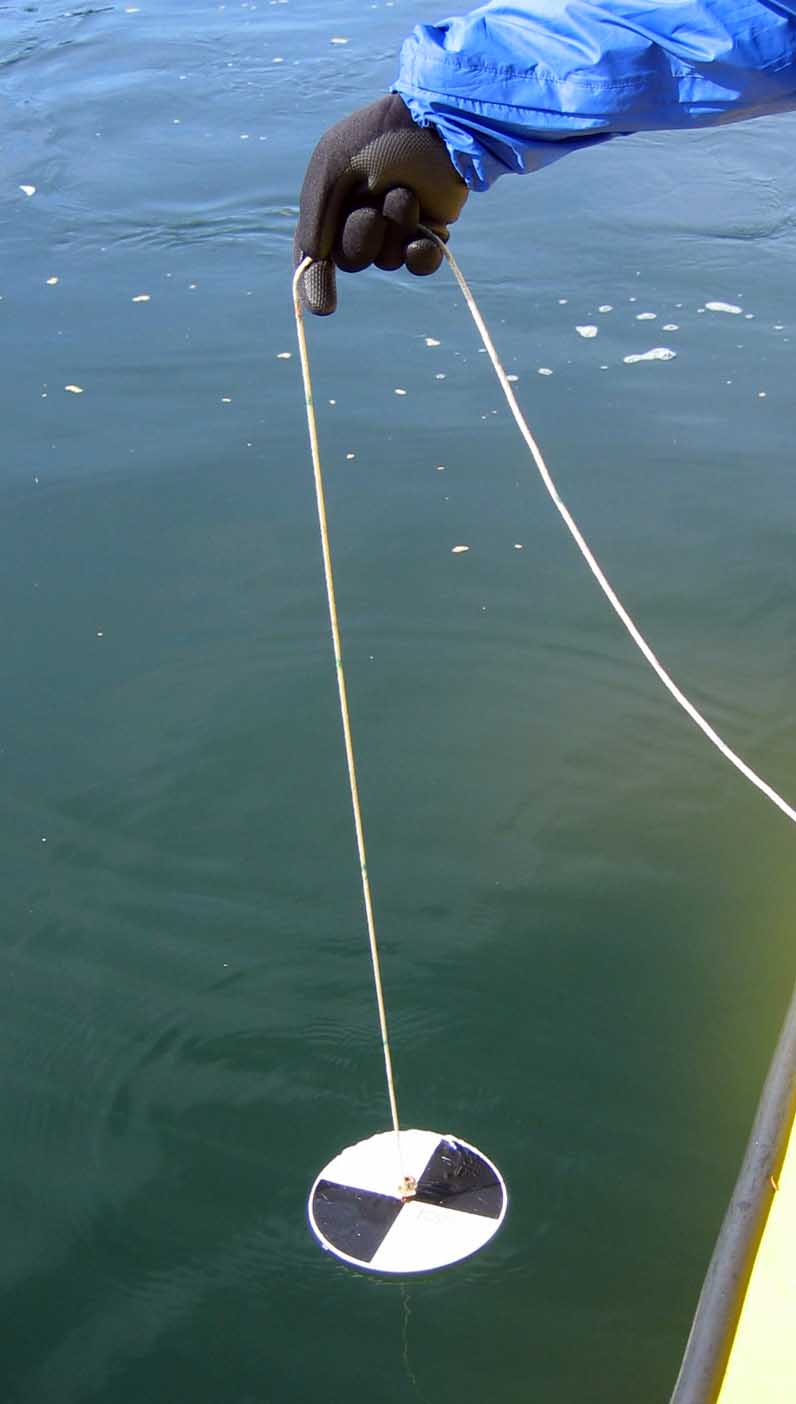
Turbidity
The distance light penetrates is affected by the turbidity (cloudiness) of the water. The depth of light penetration is easily measured using a Secchi disc that is white, or painted in white and black quadrants [2.2.]. The disc is attached to a string used to lower it into the water column from ship, shore, or pier until it is no longer visible. By measuring the length of string played out, one records the "Secchi disc depth".
The clarity of water is most affected by the amount of suspended material present. Suspended particles result from the erosion of mineral substrata (silts and clays sedimenting very slowly through the water column); the production of mineral particles by living aquatic organisms; the abundance of living organisms; the presence of organic particles resulting from the decomposition of dead organic matter; or the re-suspension of mineral and organic particles by water movements. Water also has colour afforded by the materials dissolved within it, but colour, although affecting Secchi disc depth to some degree, is not as significant as suspended particles in preventing light penetration.
Effect of temperature on water density
Water is most dense at about 4°C so that water that is colder or warmer than this "floats" on water at this temperature. When water is warmed by absorption of solar radiation, there is a pronounced change in temperature at the bottom of the photic zone. The change in density of the water ensures that warm water remains at the surface where it becomes further warmed, effectively dividing the water body horizontally. The water body thus becomes divided by a thermocline (defined as a region of sudden change in temperature) and stratification is maintained unless water is circulated by winds or currents.
Stratification in oceans
Tropical oceans have good light penetration to depths of several hundred metres and high rates of insolation throughout the year. The thermocline is thus deep and permanent here, something which has a profound effect on the biology of tropical oceans. In polar oceans the water is constantly mixed, and warming of the surface waters is insufficient to allow a thermocline to form. Inputs of melted snow and ice near the polar ice caps also act to buffer the effects of rising temperature at the water surface. Temperate oceans show a range of patterns of stratification depending on latitude. Regions near the tropics may be permanently stratified and those at high latitudes may have little or no development of a thermocline. Most temperate oceans stratify during the summer months but the higher turbidity of these waters means that the thermocline is shallower than in tropical oceans and thus is easier to disrupt by wind action, especially during the time of decreasing temperatures in autumn. There is often a further thermocline closer to the water surface in summer when the most surficial waters become strongly warmed.
Below the photic zone the water of oceans is uniformly cold (ranging from -1°C to 4°C), and the depth and volume of water precludes vertical mixing except by ocean currents. However, this cold world has some regions where the water is very much warmer because of geothermal inputs.
Stratification and meromixis in lakes
Lakes also stratify after absorption of solar energy warms the surface waters to form a warm epilimnion overlying the colder hypolimnion [2.3.]. Various sequences of stratification are found and these are defined by the seasonal pattern of water mixing. Thus, dimictic lakes are those where the water column becomes mixed twice a year after thermal stratification, monomictic lakes where this happens only once. Polymictic lakes are those where stratification and mixing occur frequently within the year; amictic lakes do not stratify as ice cover prevents high insolation.
The dimictic pattern of stratification is characteristic of lakes within continental land masses having cold winters and hot summers. The winter stratification is caused by temperature inversion, the very cold surface waters overlying the slight less cold dense waters at 4°C [2.4.]. Usually, the-air-water interface becomes covered with ice that melts during spring to produce even temperatures through the water body and thus the first period of mixing, the spring overturn. High insolation during summer ensures that the surface waters are warmed to give a similar pattern to that seen in temperate oceans. Cooling in autumn allows the whole water body to be circulated by winds to give the second period of mixing for the year, the autumn (fall) overturn.
Several types of monomictic lake are found but they are characteristic of temperate islands and continental regions where temperatures are not too cold in winter. The stratification occurs only during the summer months with an overturn in autumn.
In some lakes the whole water body does not mix at overturn because water near the bed is of such high density that it resists the turbulent mixing forces. Such meromictic lakes result from heavy inputs of organic matter and its metabolism, or from incursion of salt water. Although the main body of water becomes mixed, the isolation of a chemically rich layer over the substratum has major consequences for the biology of benthic organisms in these lakes.
Ice cover and evaporation from the water surface
During insolation the immediate water surface becomes very warm and evaporation of water and volatile organic compounds occurs. In contrast, lakes and parts of oceans at high latitudes, and lakes at high altitudes, also become covered with ice during the winter months. This is an effective barrier to diffusion of gases but not to light. Anyone who has been under ice sheets during daylight is aware that light transmission through ice is reasonably good, although not high enough for absorption to counteract the effects of very cold air temperatures maintaining ice cover. Light passes through ice much less effectively when a covering of snow is present.
Water depth and pressure
The effects of water depth on pressure are very significant only in oceans. Exploration of the deep ocean by humans was limited to trawling before the advent of bathyscaphs and other submersibles that could resist the pressure of the enormous column of water overlying the ocean bed. In addition to the direct effect of pressure on organisms, there are indirect effects. For example, high pressure will result in a higher boiling point of water, and water temperatures considerably in excess of 100oC are found in some parts of deep oceans receiving geothermally-heated water.
Temperature in streams and rivers
The pattern of temperature in streams of low order is quite different to that in lakes and oceans. The main reason for the difference reflects the function of streams in draining valleys, some of which have a large area for insolation and therefore absorption of solar energy. During daylight, water in surface run-off is heated and, conversely, is cooled at night when thermal energy passes from the land to the atmosphere. Upland streams in unforested watersheds thus show seasonal changes in temperature (where seasons are present) but the most dramatic change in temperature is on a diel (through 24 hours) basis. Upland streams are at their warmest in the afternoon and their coolest just before dawn, although this pattern is modulated by cloud cover (reduction of isolation), rainfall (rapid runoff of cool water) and by the presence of woodland (providing cover, with water spending little time in contact with regions receiving high insolation).
Rivers of high order show a reduced diel temperature flux as their large water volume induces thermal inertia. They can be warm, and stratification can occur when air temperature and insolation are consistently high, but this is a feature largely of embayments and pools away from the main channel.
Ice over the substratum in streams and rivers
The most obvious type of ice cover is when water freezes at the surface, just as in lakes [2.5.]. Larger streams and rivers continue to discharge under a covering of ice but small streams and waterfalls often become completely frozen. Anchor ice forms when water freezes on the substratum. When a land mass cools below 0oC, any water in contact with the substratum freezes, especially if the stream or river is slow flowing. The substratum of streams and rivers often contains stones that have almost stationary or slowly flowing water between them and anchor ice forms here as a result. It serves to lock the substratum into a benthic ice sheet.
Solar and lunar influences on tidal cycles
Tides are obvious features of marine coasts. When the tide is in, the sea restricts beaches and when it ebbs, much more of the beach is exposed. The difference in water height between low and high tides varies, the greatest range being found with spring tides. High spring tides bring water far up the shore and low spring tides expose substrata that are submerged for most of the year.
Tides result from gravitational forces exerted by the Moon, and to a lesser extent the Sun, on very large water bodies [2.6.]. They are thus confined to oceans and their margins. Where the gravitational pull is strongest there is a rise in water level and where it is at its weakest there is a reciprocal decrease in water level. The Earth-Moon system also creates centrifugal forces that pull water outwards from the opposite surface of the Earth to that nearest the Moon. Two slight bulges thus occur in oceanic water masses, with two regions of marginally lower water level separating them. As the Earth rotates once every 24 hours, there are two high tides and two low tides each day. The gravitational pull of the Sun and the Moon are highest when both are in line and this creates spring tides. Neap tides, which show the lowest difference between high and low tide levels, occur when the gravitational pull of the Sun and the Moon are at right angles, so that the weak gravitational pull of the Sun pulls some water away from the principal bulges.
Meteorological factors creating winds
In addition to its effect on tides, and as a provider of light, the Sun also affects weather. Outside the tropics, there are seasonal changes in light intensity and these are pronounced at higher latitudes, with the sun striking the water surface at a narrow angle. The Sun, and linked meteorological factors, also affects patterns of wind flow and rainfall. We can identify two sets of winds: those that are in the high atmosphere (the jet stream) and those close to the surface of the Earth, impacting with the surface of water bodies. The jet stream influences the direction and intensity of weather fronts and the distribution of high and low pressure air which so dominate weather. Lower level winds generated by these weather systems then have an important effect on another feature of many water bodies - waves.
Wind fetch and waves
When we were very young we looked at waves and imagined that their water travelled from some distant land. It was disappointing to be told that although waves travel the water forming them does not, yet this is obvious if one looks at flotsam moving up and down in the water as waves pass. However, waves do move objects on shores and, when large, do so dramatically.
Waves are principally a feature of large water bodies. The longer the wind fetch (distance through which the wind is blowing) and the stronger the wind, the larger the waves. Water molecules circulate rapidly as wave fronts pass so there is a strong motion within the water column, but only very near the surface. In deeper water there is no movement of water when waves pass at the surface.
Waves approaching shores shorten in wavelength as the zone of rapid water circulation comes into contact with the substratum [2.7.]. This causes the water near the substratum to decelerate but the wave crest maintains momentum and begins to break to form surf. Water then moves rapidly up the shore, gravity causing the water from each wave to ebb back to the sea. If the shore is steeply sloping and wave fetch is long, the huge breakers favoured by surfers are found. These waves erode the shore, water being propelled at force and sometimes from considerable height. Wave-washed shores exposed to prevailing winds are commonly rocky as smaller mineral substrata become carried away and deposited elsewhere along the coast. Sand and shingle beaches can also receive vigorous wave action and the substratum is then moved around, as all those who paddle at the seaside or at the margins of large lakes are aware. When stormy seas and wave action coincide with high tides, there is often heavy erosion of the coast.
Lakes change in water level for various reasons but the effect of tide in erosion is not a factor here.Where lake and marine shores are sheltered from prevailing winds, and where the shore is very shallow, the effect of waves is much less and these shores are characteristically depositional.
Tidal waves
Tidal waves are formed when volcanic eruptions, or landslips, cause a large and sudden displacement of water within oceans. Tidal waves, referred to as tsunamis [2.8.] when very large, travel rapidly over considerable distances if they have sufficient energy and their impact with land can be disastrous. Tidal waves result in the swamping of some coastal regions but their origin makes it difficult to predict precisely when they are going to occur and in what magnitude.
Currents, turbulence and other water movements
Large-scale water movements in the past
If we go back though geological time the position of continents and oceans was very different to that of today. 60 million years ago a circum-equatorial warm water current passed around the globe through what is now the land mass of Panama, and between what is now Africa and Asia Minor to exit through the contemporary Mediterranean. Existing large-scale water currents must be viewed against this background. For example, the contemporary North Atlantic drift became more pronounced and saltier when the Panama Gateway became closed. The recent Ice Age also had an effect on the amount of water in circulation, promoting a 120 m drop in the height of sea level compared to the levels of today.
Surface and deep-sea ocean currents
Surface ocean currents are familiar features e.g. the North Atlantic Drift [2.9.]. Less familiar are the deep-sea currents often moving water in the opposite direction to that at the surface. Where deep-sea currents run through gaps in submarine ridges the water accelerates to produce analogues of waterfalls in the terrestrial landscape.
Water is drawn down from the surface into the deep-sea currents at regions of downwelling, especially from high latitude oceans. Reciprocally, water from the deep ocean is carried up to the surface at upwellings caused by continental slopes and wind-driven surface currents. We will see that upwellings have a very important role in the biology of adjacent marine habitats. Upwellings and downwellings are also formed where ocean currents collide or are moved in opposite directions.
Sometimes, warming of the surface water of the oceans causes differences in the pattern of upwelling and this is especially so in the Pacific. Warming prevents the major upwelling near the western coast of South America and the consequences of such El Niño events are considerable, both for global weather patterns and for local biological productivity.
Gyres, whirlpools and tidal races
Where surface currents are carrying water in one direction, it is clear that interfaces with slower flowing or still masses of water will create resistance and the formation of gyres and whirlpools. Both involve the rotation of water masses with gyres being on a large scale, often covering many kilometres, and whirlpools on a smaller scale. The direction of movement is affected by the Earth's rotation and is characteristically opposite in the northern and southern hemispheres. Over continental shelves there is a compounding effect of tidal water movement that generates tidal races, masses of water moving at different speeds and in different directions to create much surface turbulence.
Surges, seiches and the El Niño southern oscillation (ENSO)
Where winds have been blowing strongly and consistently in one direction, water is moved downwind. This is especially pronounced in coastal regions where the sea narrows between large land masses. Should these surges coincide with high tides there is a much-increased risk of coastal flooding and sea walls are often constructed to prevent this. When the wind dies down, water moves back to leeward. High discharges from rivers, coinciding with tidal surges, have the potential for catastrophic flooding of lowlands. As a result, movable barriers have been built at some locations to prevent incursion of tidal surges into estuaries, thus preventing river drainage and the need for high walls upstream from barriers to protect from flooding by river water.
Similar, surging movements of water occur in lakes where strong, directional winds cause water to reach a higher level on the exposed shore with a reverse movement of water toward the lee shore when the wind drops. The momentum of the water is such that it does not stop there but returns back across the lake, albeit at a lower amplitude. This is called a surface seiche. It is analogous to the end-to-end movement of water so enjoyed by young children playing in bathtubs.
A different pattern of seiche occurs in stratified lakes. As it is less dense, the warm water of the epilimnion is blown downwind, forcing the thermocline to be depressed. When the wind dies down, the warm water then moves back across the lake, depressing the thermocline on the opposite shoreline. The thermocline is thus oscillating and the oscillations continue until dampened by inertia. This is called an internal seiche.
El Niño and La Niña
A similar depression of the thermocline, albeit on a vast scale, occurs in oceans. For example, the western tropical Pacific usually has a deep thermocline as prevailing westerly trade winds cause warm surface water to be moved to the west. This allows upwelling of cold water in the easterly part of the basin. If the trade winds are of lower than usual magnitude the piling up of warm water is less pronounced, the thermocline is more level and the upwellings of the eastern basin are prevented from reaching the surface. This is termed the El Niño southern oscillation (ENSO) [2.10.], and El Niño years are often, but not always, followed by La Niña events when the waters of the eastern Pacific become colder than the norm. El Niño has a major effect on climate around the tropical Pacific with higher rainfall in the eastern basin often resulting in destructive flooding. Conversely, the western basin is much drier than in normal years with consequent periods of drought and often devastating bush fires. La Niña years see Australia and Indonesia receiving heavier than normal rainfall.
Drainage patterns in rivers and their consequence
Rivers and streams show a quite different water movement. As we saw earlier, streams and rivers form in channels and valleys, to drain water from the surface of land by gravity. In low order streams, the profile is steep and the substratum here is often stony, streams and rivers of high order having a characteristically silty substratum. Upland streams are thus principally erosive and large rivers are depositional over their beds, even though both have rapid current velocities at the surface. In high order rivers the mass of water has a large inertia and current velocity diminishes with depth, velocity being very much reduced near the bed and thus promoting deposition of particles. In contrast, streams of low order are shallow and current velocity is high throughout the water column, eroding the substratum at intervals.
With increasing current velocity there is an exponential increase in the size of particles moved. Rivers receiving snow melt drainage from high mountain ranges often have a substratum of large rocks > 1 m in diameter as current velocity exceeds 3 m s-1 during floods, the rivers being very turbulent throughout their depth. Of course, smaller stones and mineral particles will be protected from current velocity between these stones, but the visible substratum is rocky.
Erosion of river banks also occurs and this is often pronounced during times of high discharge. We are familiar with rivers undercutting their banks and the characteristic meandering pattern of many lowland rivers results from alternate erosion and deposition around bends as the river flows downstream [2.11.]. The meanders also "move downstream" over time as the pattern of erosion and deposition causes alteration in the line of maximum current velocity.
The erosion of river beds is similar to the action of waves in lakes and on marine coasts. The erosive force is largely unidirectional (from upstream to downstream) in rivers, but water ebbs and flows over marine coasts and waves impact from height. Another similarity between water bodies is that the movement of water at the surface is faster than at depth, this being true of oceans, lakes and the largest rivers.
Flooding and wetlands
From time to time rivers break their banks and water then spills on to the flood plain [2.12.]. This is a natural event but human communities living on the flood plain are faced with havoc as a result. As we have seen, periodic and often seasonal flooding by rivers brings alluvial deposits that are fertile and allow good yields of crops. Materials that have accumulated on the flood plain are also carried to the river when water levels decrease after flooding and this input is of major importance to the biology of some rivers.
Wetlands [2.13.] are inundated with groundwater or surface drainage water. Those fed by rivers often have a very slow flow of water passing through them, being effectively lateral extensions of the drainage channel. Unless drained by human activity, or present in regions with a dry season, wetlands are permanent. Terrestrial plants requiring very moist growing conditions are characteristic of marshes and swamps and they grow abundantly.
Flooding at the coast brings an influx of sea water, with a salinity not tolerated by many terrestrial organisms. Salt marshes are found where flooding by sea water is commonplace and only plants and animals that tolerate salinity thrive here. Such communities are also found commonly in estuaries and coastal regions where tides bring an influx of sea water twice each day.
Turbulence in water, Langmuir circulation and bubbles
In addition to large-scale water movements in oceans, lakes and rivers, there are many smaller-scale movements. When storms subside there are frequently streaks of white spume (commonly called windrows [2.14.]) on the surface of lakes or the sea and these run parallel to the direction in which the wind was blowing. Streaks also result from Langmuir circulation, a surface effect that causes rotation of cylinders of water [2.14.] under certain conditions. These streaks are formed from floating materials and air bubbles of many sizes that are coated with organic matter and have a much longer duration than bubbles without such coverings. This spume, less ordered into lines, is also characteristic of the surface of the sea or lakes during vigorous wave action, or the passage of ships. The surface of streams and rivers below regions of "white water" frequently bears spume too, especially where the water is rich in organic matter to provide a coating for the bubbles.
Turbulence also occurs on very small, even microscopic, scales. For example, it may be caused by flowing water passing a small obstruction, by convection currents, or be created by the movements of living organisms. In the first example, the turbulence will be a feature as long as the obstruction remains. In the second and third examples, the turbulence is often transitory. Whatever its scale and duration, turbulence generates shear forces that play an important role in trophic biology.
Bubbles and the air-water interface
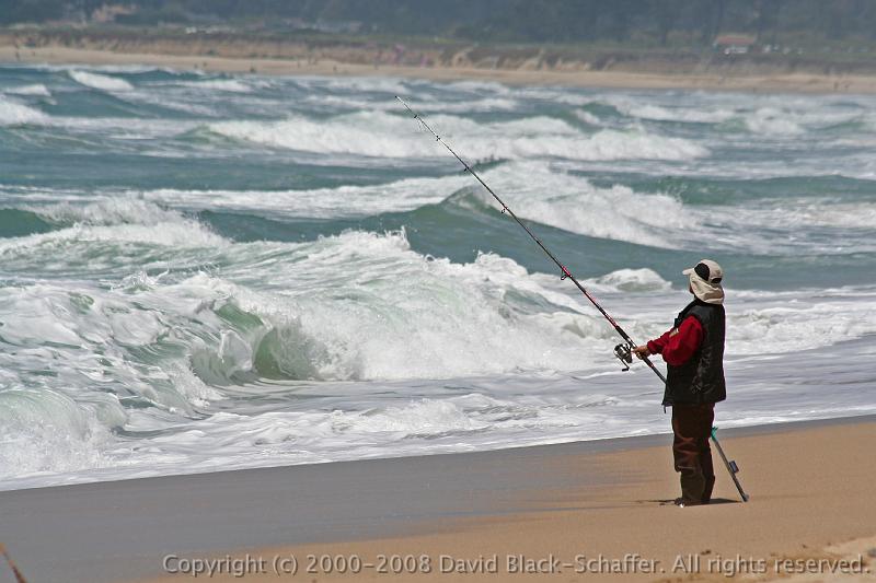
The whiteness of waves, waterfalls and tumbling water [2.15., 2.16.] is caused by the temporary inclusion of bubbles and this is a very common feature of the surface of many water bodies. Bubbles are also formed within the water column by the escape of gases, or by biological processes. However they are formed, bubbles are inclusions of gas surrounded by water and result in a dramatic increase in the quantity of gas-water interface present. Although water covers 70% of the Earth's surface, we are only now beginning to recognise the importance of the air-water interface and the biological significance of bubbles. We will return to this topic later in the narrative but we should note here that the air-water interface has important physical and chemical properties: it can support objects; all light must pass across it; and it provides conditions where hydrophobic materials accumulate.
Chemical constituents of marine and fresh waters
Water as a solvent
Many chemicals are soluble in water, some rapidly and others over long periods. As there is such a huge volume of water on the planet, and much has been present for a substantial period of time, contemporary water bodies contain many chemicals in solution. The principal sources of solutes are minerals and rocks with which water is in contact. If these minerals contain sodium chloride it leaches into water and makes it salty. Similarly, if underlying rock strata contain calcium salts these leach out into solution, increasing calcium ion concentration.
Contemporary sea water is of remarkably constant inorganic chemical content, varying significantly only with inputs of hydrothermal water, freshwater drainage, melting ice caps, rainfall, and output through evaporation. The constancy is maintained by circulation and mixing [2.17.]. In contrast, fresh waters vary in their chemical composition [2.18.]. Where rain water falls on igneous rocks there is little solubility of minerals and the water is consequently little different in mineral content to the incoming rain. Where water bodies are present on sedimentary rocks there is increased calcium ion concentration and waters are described as being hard, evaporation leaving a deposit familiar to us as limescale [2.19.]. For a number of reasons, not the least being their youth compared with the sea, fresh waters have a low ionic content. However, this generalisation needs qualification. Some fresh waters have very high levels of dissolved minerals, especially where there are inputs of water from volcanic activity. Some lakes also evaporate regularly, concentrating minerals as they do so - soda lakes and salt lakes [2.20.] provide examples where ionic concentration can exceed levels found in the sea.
pH buffering capacity
Sea water is well buffered against changes in acidity and there is also such a large amount of water to dilute acidic inputs. Fresh waters are more prone to changes in pH and lakes having water with few dissolved minerals are especially vulnerable. The principal buffering system against changes in pH involves the conversion of bicarbonate to carbonate and vice versa:
bicarbonate + hydroxyl ions = carbonate + water
Addition of acids neutralises the hydroxyl ions and this is compensated by solution of carbonate in water. It is clear that lakes in regions where the underlying rock strata are sedimentary are effectively buffered against inputs of acid as their water contains relatively high levels of calcium carbonate. Lake waters that are naturally acidic, or which have low calcium ion concentration, are poorly buffered and their biological communities can become adversely affected. This is why "acid rain", resulting from industrial emission of gases (such as sulphur dioxide) that dissolve in water to produce strong acids, has created such a problem in some areas of the World.
Nutrients, especially N, P and Si
Nitrogen and phosphorus are essential nutrients as they form the basis of proteins and of the ATP used in energy production. Increases in these nutrients fertilise water just as they do on land when added to increase crop production. Both nitrogen and phosphorus arrive in water bodies in a number of ways and the trapping and release of these nutrients by organisms underpins biological productivity [2.21.].
There are several other essential nutrients or micronutrients, e.g., vitamins, iron, and, for some algae, silicon is essential. Diatoms produce siliceous frustules that surround the living tissue. These frustules survive death of the algae and provide a record of water conditions over time as they accumulate in laminated sediments. This is silicon in particulate form but it can occur in solution and is commonly encountered adsorbed on to mineral, or organic, particles.
Organic matter
All waters contain a diverse array of organic compounds, both in solution and as colloids. It was from this organic material that life began and living organisms contribute to, and metabolise, the organic matter pool. We will assess the importance of this processing in later chapters, but it is worth introducing two categories at this point - labile organic matter and refractory organic matter. Labile material is sometimes defined as that taken up by active transport across cell walls and can therefore be utilised directly by living organisms (in chemical terms it has a molecular weight < 1 kD). Refractory organic matter needs to be broken down into lower molecular weight labile compounds before transport across cell walls and organisms have evolved a number of ways to achieve this. Breakdown of organic matter also occurs by physico-chemical processes.
Much organic matter in water is highly refractory and it can have a residence time within oceans and lakes of hundreds or even thousands of years. By its nature, labile organic matter is utilised rapidly and it often has a short duration outside organisms.
Dissolved gases
Nitrogen is more soluble in water than oxygen and is therefore proportionally more abundant and, as we have seen, provides an essential source of nutrients when taken up by organisms. Nevertheless, oxygen readily dissolves in water and solution at the air-water interface is important in maintaining oxygen levels. The atmosphere is not the only source of oxygen as this gas is generated by photosynthesis, the biochemical process that has given us the oxygen-rich atmosphere that sustains most modern life. Conversely, oxygen is taken up by organisms that respire aerobically.
The solubility of oxygen in water varies with temperature, an increase in temperature causing a reduction in solubility. In stratified waters like tropical oceans and many lakes, there is thus a lower level of oxygen in surface waters relative to those at depth. However, surface waters do not become deprived of oxygen as the gas diffuses into the water from the atmosphere. Where lakes are stratified, and have a high organic loading, oxygen is depleted in the hypolimnion by the metabolism of aerobic organisms and only anaerobes survive at the lowest oxygen levels [2.22.]. The turnover of lakes ensures that the whole water column again becomes oxygenated. Normally, a dramatic reduction in oxygen tension does not occur in oceans without anthropogenic inputs of materials like sewage sludge. Like rivers, oceans remain well oxygenated throughout the water column, although levels of oxygen can fluctuate around zones of high biological activity, and anoxia can then develop.
Carbon dioxide also dissolves in water to form the loosely-associated carbonic acid. When falling as rain, this slowly erodes calcareous rocks and results in input of calcium salts to adjacent water bodies during drainage. Any atmospheric gases that are soluble in water will pass into water bodies during rainfall as we saw when describing acid rain.
Numerous gases are produced within the water column in addition to the oxygen resulting from photosynthesis and carbon dioxide from respiration. For example, reducing conditions in sediments result in the production of methane and hydrogen sulphide and these gases also arrive in water bodies from volcanic origins. Reducing conditions pertain close to the surface of many aquatic sediments as all of us who have walked on mudflats or dug into lake sediments is aware: there is always the characteristic pungent smell associated with anaerobic decomposition.
2.1. http://oceanexplorer.noaa.gov/explorations/04deepscope/background/deeplight/media/diagram3.html
2.2. http://courses.washington.edu/uwtoce06/webg3/images/secchi2.jpg
2.3. http://www.lakeaccess.org/ecology/lakeecologyprim4.html
2.4. http://faculty.gvsu.edu/videticp/stratification.htm
2.5. http://www2.gi.alaska.edu/ScienceForum/ASF8/815.html
2.6. http://oceanservice.noaa.gov/education/kits/tides/tides01_intro.html
2.7. http://faculty.gvsu.edu/videticp/waves.htm
2.8. http://earthweb.ess.washington.edu/tsunami/index.html
2.9. http://www.atmosphere.mpg.de/enid/2_The_Oceans/Background_gulf_stream_6f2.html
2.10. http://www.elnino.noaa.gov/
2.11. http://www.bbc.co.uk/learningzone/clips/rivers-meanders/403.html
2.12. http://www.ghcma.vic.gov.au/water/floodplain-management/what-is-a-floodplain/
2.13. http://water.epa.gov/type/wetlands/index.cfm
2.14. http://homepages.cae.wisc.edu/~chinwu/CEE514_Coastal_Engineering/2001_Students_Web/Dave_Calkins/Main.html
2.15. http://cva.stanford.edu/people/davidbbs/photos/artsy/slides/IMG_4889%20man%20fishing%20waves%20surf%20ocean%20beach%20artsy.JPG
2.16. http://image03.webshots.com/3/0/84/92/18508492KfOoXJutaJ_ph.jpg
2.17. http://www.waterencyclopedia.com/Mi-Oc/Ocean-Mixing.html
2.18. http://www.lakeaccess.org/ecology/lakeecologyprim6.html
2.19. http://www.fwevans.co.uk/DSCF0016.JPG
2.20. http://ut.water.usgs.gov/greatsaltlake/index.html
2.21. http://water.epa.gov/scitech/swguidance/standards/criteria/nutrients/index.cfm
2.22. http://www.ncbi.nlm.nih.gov/pmc/articles/PMC239163/