CHAPTER 1
Viewing water bodies from a terrestrial perspective
Most humans view water as an alien environment, reflecting our air-breathing and terrestrial mode of life. We rarely look beyond the water surface although film and television have enabled us to learn more about life in water, even if we have not seen the environments portrayed at first hand. We know that brightly-coloured fish are numerous around coral reefs, that sharks hunt, that wrecks are encrusted with many unfamiliar organisms. Such features are exotic and remote from our every day view of water bodies and we can only estimate the depth of water in local lakes, or the topography of the sea bed of coastlines we know well.
Our lack of awareness of what goes on beneath the surface of water bodies creates problems. Excessive dumping of organic matter brings pollution and toxic organisms; pesticides and chemical spillages make water poisonous; fishing and whaling stocks are threatened. There are many other examples and all point to our need for a better understanding of water bodies and the processes that occur within them.
Drinking water and the disposal of wastes
All living organisms are dependent on water to complete their life cycles as water is an essential component of cells. The earliest sources of water for human consumption were rivers, lakes and ponds from which water was collected for drinking and cooking. Waste was then discharged on to local land to fertilise crops, or into ponds and rivers (downstream from settlements) to increase the production of fish. When early humans abandoned a nomadic, hunter/gatherer life for a more settled existence where hunting was supplemented by growth of crops, villages developed and then towns and cities. Although urban planning has existed for thousands of years, it is only relatively recently that we have learned the consequences of pollution both of drinking water supplies and of habitats. Nevertheless, human populations still encounter major problems with their water supply, and provision of clean water to communities throughout the World remains an important challenge.
Water and human transport
Water has always been used by humans as a means of transport. Early humans used rafts and simply-constructed boats to move on the surface of water and thus migrate, or carry cargo from one location to another. After societies developed there was a need to explore and conquer new territories and some migrations on water took place over long distances. As towns and cities developed near rivers, coasts or on lakeshores, transport was needed to conduct trade and to bring in essential supplies, most of which could no longer be provided locally. This led to trading and shipping routes but this is a slow method of transport, although large cargoes are still carried by sea.
Providing human food from water
Water bodies also contain important sources of food. Aquatic plants and animals, both vertebrates and invertebrates, have been harvested for a very long time and remain a staple diet of many human communities. As settlements grew larger and transport links developed, food acquisition became commercialised and stocks were no longer an easily monitored local resource. This commercialisation has led to over-exploitation of natural stocks and we have developed farming techniques to supply demand, although the farming of marine and freshwater organisms by human societies has ancient origins.
Irrigation of crops
Fresh water is needed to irrigate terrestrial or emergent crop plants and is drawn from rivers, lakes, impoundments and containers of many kinds. Many rivers also provide fertile alluvium when water levels drop after seasonal flooding. Irrigation schemes use channels and dikes to duct water to crops that are sometimes maintained under water, as in rice paddies. Large-scale irrigation schemes often impound rivers to allow a more regular discharge of water than would occur naturally, when droughts, unpredictable pulses of water, and seasonal floods were the norm. This has the advantage of extending growing seasons and ensuring the regular production of crops. Water is of special significance in deserts where rainfall is very low or non-existent. Oases are essential in allowing human colonisation and in providing watering holes for pack animals used in trade and migration.
Driving machinery, or generating power, using water
Moving water provides an important source of energy that can be harnessed to drive machinery or generate power. Until the advent of large steam engines, mill streams were cut to divert some river water over a water wheel used to power rotating mill wheels or other machinery. Often, an upstream lake was created by impoundment to ensure that there was a near constant head of water. This principle developed into the use of turbines for power generation, large rivers being dammed and water passing though pipes to generators, often with a considerable drop in vertical water level to ensure maximum power output. Although some countries are dependent on hydroelectric power generation for a significant amount of their power supplies, this source is usually secondary to power generation as a result of burning fossil fuels or from nuclear reactions. The sea is also used for generating power, advantage being taken of tidal cycles or the action of waves. At present, these technologies are expensive to develop, produce, and maintain for the amount of power that is generated.
Water and recreation
Most of us like to spend time near water. Many holidays are taken by the sea or large lakes so that we can enjoy paddling, swimming, boating, fishing and other aquatic recreations. Sport fishing is a major pastime in many parts of the world and anglers are among the most acute observers of the aquatic world. Water is also important aesthetically, featuring in paintings, ceramics and garden design as well as being an inspiration to composers of music.
The range of water bodies found on Earth
The area of the Earth's surface that is covered with water
More than two thirds of the Earth's surface is covered with water and most of that is sea water. Even though some lakes appear huge (e.g. the Great Lakes, Lake Baikal, the Rift Valley lakes in Africa), their total surface area is very small compared to that of the oceans [1.1.; 1.2.]. The surface area of rivers is smaller again, but rivers drain large areas of land and the discharge of water along rivers is considerable.
Water probably originated from volcanic activity and has been present on Earth from the earliest times as a gas, liquid or solid. Although vast quantities of ice remain at the poles, the majority of water today is found in the liquid phase. Ice caps undergo long-term changes of formation and melting, but high latitudes also have areas where ice and snow remain for about half the year, melting rapidly as summer approaches and discharging in very swollen rivers. At high altitudes, snow and ice remain as permanent features, just as they do at the Poles.
The water cycle
Water evaporates from the surface of water bodies and from the land. Terrestrial vegetation also draws water from within soils, emitting water vapour during transpiration from leaves. Water vapour from all sources condenses into clouds that are carried by winds until local conditions cause precipitation, with rain and snow falling back to the Earth's surface [1.3.]. Movements of clouds are influenced by prevailing jet streams in the atmosphere and much of the rain that falls on land has evaporated from the huge surface of the oceans, often a considerable distance away. When rain falls on land it flows into rivers and is then eventually discharged to the sea to complete the last part of the water cycle. However, water doesn't only drain the surface of the land; it also soaks into the earth and into porous rock strata to form groundwater that discharges as springs and underground rivers.
There is a wide diversity of water bodies on Earth, some being ancient and others very recent. As a means of reference, and for understanding similarities and differences between systems, a classification of water bodies is required.
Oceans
Water in contemporary oceans comes from rainfall, melting ice, discharging rivers, and from land runoff. Much the largest input is from rain, although current patterns of global warming indicate that water from melted ice is of increasing importance near the poles. Throughout time, there have been alternating changes in climate between warm and cold eras and the contemporary warming is part of this continuing pattern. The huge surface area of oceans means that evaporation from their surface is similarly large.
Most oceans have a depth of considerably more than 2,000 m for much of their area, becoming shallower near the continents. Close to land masses the sea bed slopes gently to form a continental shelf that varies in width depending on location. Beyond the shelf the margin of the continents descends more strongly as the continental slope which, at a depth of about 4,000 m, merges into the abyssal plain or ocean bed [1.4.].
The abyssal depths are still largely unexplored, the term "inner space" being used to describe these ocean waters. Mostly, the ocean bed consists of fine sediments (ooze) but there are regions where volcanic and tectonic activity is high, especially near tectonic plate margins. This results in submarine mountain ranges, some of which reach the water surface as oceanic islands. There are also deep trenches, the deepest exceeding 10,000 m from the water surface (Mount Everest is 8,848 m high). Some atlases show the ocean bed in a three-dimensional format but the topography of the sea bed is understandably much less familiar to us than the distribution of terrestrial mountain ranges and valleys.
Marine coasts vary widely in structure depending on prevailing winds, rock strata, latitude and climate zone. Where there is strong wave action shores are rocky, shingly or sandy, where there is shelter from wave action the shore is muddy. In some regions the muddy, sheltered shore allows the development of seagrass meadows and mangrove swamps, sometimes making the boundary between coast and land indistinct. Coral reefs are found in tropical seas, and these are biogenic features as the underlying rock is secreted by the corals themselves (although rock-forming corals are only one component of reefs).
Lakes
As they are so varied in form, the classification of lakes presents problems, and inland water bodies range from small pools through to inland seas. Some are ancient, others very recent, and there are also major differences in water chemistry across the range of types. If lakes are classified by their origins, we can identify factors that influence their size and indicate their age. This also influences the chemical composition of their water and thus their biology.
The largest, oldest lakes are those of tectonic origin. The Rift Valley lakes of Africa formed when movements of tectonic plates allowed part of the Earth's crust to drop between two regions of faulting. This occurred over 2 million years ago, making these rift valley lakes some of the oldest large bodies of fresh water. Other lakes formed by faulting and uplifting, sometimes having a region of ancient ocean trapped within a land mass, the water thus isolated becoming less salty with time.
During the last Ice Age, polar ice sheets extended to lower latitudes and these sheets had an abrasive effect on underlying rock strata. Some strata were eroded more than others and lakes were formed in the resulting depressions after retreat of the ice sheets. Erosion also occurred along glaciated river valleys, resulting in a series of lakes through which the contemporary river flows on its way to the sea. Lakes resulting from the last Ice Age are relatively recent, and most large lakes in temperate latitudes have this origin. However, there are contemporary lakes in Antarctica that are probably more than 500,000 years old and which are covered by several kilometres of ice, the pressure generated by the weight of ice preventing the water freezing.
Lakes are also formed by volcanic activity (within the crater, or by lava flows damming rivers); solution (common in areas where calcium carbonate is the dominant mineral in rocks, and where cave pools are also common); filling of depressions on impervious strata or in peat deposits; or by flooding of saturated soil causing landslides within river valleys. Lakes have also been created by human activity. These vary in size, as impoundments of rivers can create huge lakes (e.g. Lakes Nasser and Kariba in Africa, Three Gorges Lake in China) while ornamental ponds in gardens can be less than a metre across.
There is no commonly accepted definition that separates pools, ponds and lakes, the former two being smaller versions of the latter. Large pools are formed by mechanisms similar to those described for lakes but small pools are found wherever rain or splashes fill depressions on land. Small pools are also found in vegetation. Tree holes, formed between exposed roots or where a branch has broken off, are common features of woodland, and tropical forests have communities of organisms living in the axils of leaves or leaf bases. Add to this the presence of communities within the pitchers of pitcher plants and one sees the huge diversity of inland waters.
The water in lakes comes from rainfall, runoff from the surrounding land, inputs from groundwater and inputs from influent rivers. Inputs from groundwater and over the surface of the surrounding land are more important in small lakes than in large ones, the latter being similar to oceans in this respect. Impoundments and some glacier lakes receive most of their water from inflowing rivers. There will often be an outflow of water via a stream or river and the discharge into and from a lake is used to calculate the residence time of the water body, although they are permanent bodies of water in a conventional sense. Lakes in regions with seasonal rainfall exist as water bodies for part of the year and some temporary pools only exist for days.
In large lakes there are usually exposed shores and sheltered shores depending on wind direction and local topography. The substratum of exposed shores is stony and much finer mineral particles are characteristic of sheltered shores. In the deep parts of lakes the substratum consists of fine particles of both mineral and organic origin.
Streams and rivers
The water in streams and rivers flows from the surrounding land, entering from surface runoff or from runoff through soils. Over time the pattern of runoff erodes a characteristic drainage pattern familiar on maps as a series of blue lines that coalesce to form the main channel of the river discharging at the estuary.
The characteristic drainage pattern of rivers seen on maps of scale 1:25,000 is used to produce a system of classification of streams and rivers based on stream order [1.5.]. The smallest streams appearing on the maps are all said to be of order I, whether high in the valley or much lower down. Streams increase in order when they flow into a confluence with a stream of the same order, e.g. two streams of order I flow together to form a stream of order II; two rivers of order IV combine to flow as a river of order V. Streams and rivers receive streams of lower order but these do not affect the order of the river into which they flow. We can now define a reach of a stream or river by its order and the size of rivers by the maximum order that they attain, allowing comparisons to be made between rivers. However, it is worth noting that an upland stream of order I is often very different in character to a lowland stream of order I.
Rivers discharge to the sea at estuaries which may be wide and depositional (resembling coastal marshes or mudflats), have deposited deltas with braided channels, be narrow and fast flowing, or fjordic (with a flooded, previously glaciated valley).
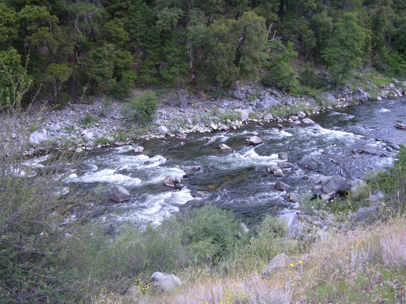
A longitudinal section through a stream from source to mouth reveals a characteristic profile. The many upland tributaries of order I are steep and shallow while the main river channel in the lowlands has deep water and a very gradual profile, often meandering from side to side as it erodes the banks. Streams of low order also contain pools with relatively deep water, these being separated by eroding areas of stony bed. In the eroding stretches the water is frequently broken at the surface and these stretches are termed riffles [1.6.]: changes in the underlying rock strata of some rivers cause rapids or waterfalls, both characterised by "white water". Within streams and rivers are "dead water zones" which are pool-like regions adjacent to the main flow and these are only incorporated with the rest of the river during periods of high discharge.
Wetlands and swamps
Any land that has large amounts of semi-permanent standing water is referred to as a wetland. Wetlands and swamps have not enjoyed a good reputation as they provide breeding grounds for biting flies and "dangerous" reptiles. They also provide poor conditions for agriculture. These perceptions of wetlands led to many wetland sites being drained and we now recognise that this was a mistake. Many wetlands are sites of important conservation interest, sites of high biological productivity and provide one mechanism for cleaning water rich in organic matter.
Are there similarities between different water bodies?
Rocky seashores, the exposed shores of lakes, and riffles in streams are similar as they all have substrata consisting of large stones with smaller mineral particles in the interstitial spaces. They are also subject to vigorous water movement. In contrast, muddy seashores, the sheltered shores of lakes and pools in rivers all have substrata consisting of fine sediments and much less vigorous water movement. The emergent vegetation typical of sheltered sea and lake shores contributes to characteristically high levels of organic matter within the sediments and this is also true of the profundal sediments. There are thus many similarities in physical nature between different water bodies and many contrasts within them.
1.1. http://www.worldlakes.org/lakeprofiles.asp
1.2. http://www.eoearth.org/view/article/154984/
1.3. http://ga.water.usgs.gov/edu/watercycle.html
1.4. http://www.harcourtschool.com/glossary/science/define/gr6/abyssal_p6c.html
1.5. http://www.fgmorph.com/fg_4_8.php
1.6. http://www.idiggold2.com/claims/images/cougar_bar/Natural-riffles.JPG